UNITED STATES
SECURITIES AND EXCHANGE COMMISSION
Washington, D.C. 20549
FORM 6-K
REPORT OF FOREIGN PRIVATE ISSUER
PURSUANT TO RULE 13a-16 OR 15d-16
UNDER THE SECURITIES EXCHANGE ACT OF 1934
For the month of: September 2025
Commission File Number: 001-34984
FIRST MAJESTIC SILVER CORP.
(Translation of registrant’s name into English)
Suite 1800 – 925 West Georgia Street
Vancouver, British Columbia V6C 3L2
(Address of principal executive offices)
Indicate by check mark whether the registrant files or will file annual reports under cover Form 20-F or Form 40-F.
Form 20-F ☐ Form 40-F ☒
DOCUMENTS FILED AS PART OF THIS FORM 6-K
SIGNATURES
Pursuant to the requirements of the Securities Exchange Act of 1934, the registrant has duly caused this report to be signed on its behalf by the undersigned, thereunto duly authorized.
| FIRST MAJESTIC SILVER CORP. |
| (Registrant) |
| /s/ Samir Patel |
| Samir Patel |
| General Counsel & Corporate Secretary |
| September 26, 2025 |
Exhibit 99.1

San Dimas Silver/Gold Mine
Durango and Sinaloa States, Mexico
NI 43-101 Technical Report on
Mineral Resource and Mineral Reserve Estimates
| Qualified Persons: | Gonzalo Mercado, P.Geo. David Rowe, CPG Michael Jarred Deal, RM SME Andrew Pocock, P.Eng. María Elena Vázquez Jaimes, P.Geo. |
| Report Prepared For: | First Majestic Silver Corp. |
| Effective Date: | August 31, 2025 | |
| Report Date: | September 24, 2025 | |
| San Dimas Silver/Gold Mine Durango and Sinaloa States, Mexico NI-43-101 Technical Report on Mineral Resource and Mineral Reserve Estimates |

|
Table of Contents
| 1. SUMMARY |
1 | |||
| 1.1. Introduction |
1 | |||
| 1.2. Property Description, Location and Access |
1 | |||
| 1.3. History |
3 | |||
| 1.4. Geological Setting, Mineralization and Deposit Types |
3 | |||
| 1.5. Exploration |
5 | |||
| 1.6. Drilling |
5 | |||
| 1.7. Sampling, Analysis and Data Verification |
6 | |||
| 1.8. Mineral Processing and Metallurgical Testing |
7 | |||
| 1.9. Mineral Resource and Mineral Reserve Estimates |
7 | |||
| 1.9.1. Mineral Resource Estimates |
7 | |||
| 1.9.2. Mineral Reserve Estimates |
11 | |||
| 1.10. Mining Operations |
14 | |||
| 1.11. Recovery Methods |
16 | |||
| 1.12. Infrastructure, Permitting and Compliance Activities |
16 | |||
| 1.13. Capital and Operating Costs |
18 | |||
| 1.14. Conclusions |
20 | |||
| 1.15. Recommendations |
20 | |||
| 2. INTRODUCTION |
21 | |||
| 2.1. Technical Report Issuer |
21 | |||
| 2.2. Terms of Reference |
21 | |||
| 2.3. Cut-off and Effective Dates |
21 | |||
| 2.4. Qualified Persons |
21 | |||
| 2.5. Site Visits |
22 | |||
| 2.6. Sources of Information |
23 | |||
| 2.7. Previously Filed Technical Reports |
23 | |||
| 2.8. Units, Currency, and Abbreviations |
23 | |||
| 3. RELIANCE ON OTHER EXPERTS |
25 | |||
| 4. PROPERTY DESCRIPTION AND LOCATION |
26 | |||
| 4.1. Property Location |
26 | |||
| 4.2. Ownership |
26 | |||
| 4.3. Mineral Tenure |
26 | |||
| 4.4. Royalties |
35 | |||
| 4.5. Surface Rights |
35 | |||
| 4.6. Permitting Considerations |
36 | |||
| 4.7. Environmental Considerations |
36 | |||
| 4.8. Existing Environmental Liabilities |
36 | |||
| 4.9. Significant Factors and Risks |
36 | |||
| 5. ACCESSIBILITY, CLIMATE, LOCAL RESOURCES, INFRASTRUCTURE, AND PHYSIOGRAPHY |
37 | |||
| 5.1. Accessibility |
37 | |||
| 5.2. Climate |
38 |
| i | September 2025 |
| San Dimas Silver/Gold Mine Durango and Sinaloa States, Mexico NI-43-101 Technical Report on Mineral Resource and Mineral Reserve Estimates |
|
| 5.3. Local Resources and Infrastructure |
39 | |||
| 5.4. Physiography |
40 | |||
| 5.5. Comment on Section 5 |
40 | |||
| 6. HISTORY |
42 | |||
| 6.1. Ownership History |
42 | |||
| 6.2. Exploration History |
44 | |||
| 6.3. Production History |
47 | |||
| 7. GEOLOGICAL SETTING AND MINERALIZATION |
48 | |||
| 7.1. Regional Geology |
48 | |||
| 7.1.1. Stratigraphy |
50 | |||
| 7.1.2. Lower Volcanic Complex (LVC) |
51 | |||
| 7.1.3. Upper Volcanic Group (UVG) |
52 | |||
| 7.1.4. Intrusive Rocks |
52 | |||
| 7.1.5. Structural Geology |
52 | |||
| 7.2. Mineralization |
54 | |||
| 7.3. Deposit Descriptions |
57 | |||
| 7.3.1. West Block |
60 | |||
| 7.3.2. Graben Block |
62 | |||
| 7.3.3. Central Block |
63 | |||
| 7.3.4. Tayoltita Block |
63 | |||
| 7.3.5. Santa Rita Area |
64 | |||
| 7.3.6. El Cristo Area |
65 | |||
| 7.3.7. Alto De Arana Area |
67 | |||
| 7.3.8. San Vicente Area |
68 | |||
| 7.3.9. Ventanas Prospect |
69 | |||
| 7.4. Comments on Section 7 |
69 | |||
| 8. MINERAL DEPOSIT TYPES |
70 | |||
| 8.1. Geological Setting |
70 | |||
| 8.2. Mineralization |
70 | |||
| 8.3. Alteration |
71 | |||
| 8.4. Applicability of the Low-Sulphidation Epithermal Model to San Dimas |
71 | |||
| 8.5. Comments on Section 8 |
73 | |||
| 9. EXPLORATION |
74 | |||
| 9.1. Introduction |
74 | |||
| 9.2. Grids and Surveys |
75 | |||
| 9.3. Geological Mapping |
75 | |||
| 9.3.1. Surface Geological Mapping |
75 | |||
| 9.3.2. Underground Geological Mapping |
77 | |||
| 9.4. Geochemical Sampling |
78 | |||
| 9.5. Geophysics |
81 | |||
| 9.6. Remote Sensing |
82 | |||
| 9.7. Tunnelling |
83 | |||
| 9.8. Petrology, Mineralogy, and Research studies |
85 | |||
| 9.9. Exploration Potential |
85 |
| ii | September 2025 |
| San Dimas Silver/Gold Mine Durango and Sinaloa States, Mexico NI-43-101 Technical Report on Mineral Resource and Mineral Reserve Estimates |
|
| 10. DRILLING |
86 | |||
| 10.1. Drill Methods |
86 | |||
| 10.2. Core Handling and Storage |
88 | |||
| 10.3. Data Collection |
88 | |||
| 10.4. Drill Hole Logging Procedure |
89 | |||
| 10.5. Core Recovery |
89 | |||
| 10.6. Collar Survey |
89 | |||
| 10.7. Downhole Survey |
89 | |||
| 10.8. Geotechnical Drilling |
89 | |||
| 10.9. Specific Gravity and Bulk Density |
90 | |||
| 10.10. Drill Core Interval Length/True Thickness |
90 | |||
| 10.11. Comments on Section 10 |
91 | |||
| 11. SAMPLE PREPARATION, ANALYSES AND SECURITY |
92 | |||
| 11.1. Sampling Methods |
92 | |||
| 11.1.1. Core Sampling |
92 | |||
| 11.1.2. Underground Production Channel Sampling |
92 | |||
| 11.2. Analytical Laboratories |
93 | |||
| 11.3. Sample Preparation and Analysis |
93 | |||
| 11.3.1. San Dimas Laboratory |
93 | |||
| 11.3.2. SGS Durango |
94 | |||
| 11.3.3. Central Laboratory |
94 | |||
| 11.3.4. ALS |
94 | |||
| 11.4. Quality Assurance and Quality Control (QAQC) |
95 | |||
| 11.4.1. Materials and Insertion Rates |
95 | |||
| 11.4.2. Transcription and Sample Handling Errors |
96 | |||
| 11.4.3. Accuracy Assessment |
96 | |||
| 11.4.4. Contamination Assessment |
98 | |||
| 11.4.5. Precision Assessment |
100 | |||
| 11.4.6. Between-Laboratory Bias Assessment |
101 | |||
| 11.5. Databases |
103 | |||
| 11.6. Sample Security |
103 | |||
| 11.6.1. Channel Samples |
103 | |||
| 11.6.2. Drill Core Samples |
103 | |||
| 11.7. Author’s Opinion and Other Comments on section 11 |
103 | |||
| 12. DATA VERIFICATION |
105 | |||
| 12.1. Data Entry Error Checks |
105 | |||
| 12.2. Visual Data Inspection |
105 | |||
| 12.3. Review QA/QC Assay Results |
106 | |||
| 12.4. Site Visits |
106 | |||
| 12.5. QP’s Opinion and Other Comments on Section 12 |
106 | |||
| 13. MINERAL PROCESSING AND METALLURGICAL TESTING |
107 | |||
| 13.1. Overview |
107 | |||
| 13.2. Metallurgical Testing |
107 | |||
| 13.2.1. Mineralogy |
107 |
| iii | September 2025 |
| San Dimas Silver/Gold Mine Durango and Sinaloa States, Mexico NI-43-101 Technical Report on Mineral Resource and Mineral Reserve Estimates |
|
| 13.2.2. Monthly Composite Samples |
108 | |||
| 13.2.3. Sample Preparation |
108 | |||
| 13.3. Comminution Evaluations |
108 | |||
| 13.4. Cyanidation, Reagent and Grind Size Evaluations |
110 | |||
| 13.5. Optimizing Process Studies |
111 | |||
| 13.6. Recovery Estimates |
113 | |||
| 13.7. Metallurgical Variability |
114 | |||
| 13.8. Deleterious Elements |
119 | |||
| 14. MINERAL RESOURCE ESTIMATES |
120 | |||
| 14.1. Introduction |
120 | |||
| 14.2. Mineral Resource Estimation Process |
120 | |||
| 14.2.1. Sample Database |
121 | |||
| 14.2.2. Geological Interpretation and Modeling |
123 | |||
| 14.2.3. Exploratory Sample Data Analysis |
124 | |||
| 14.2.4. Boundary Analysis |
125 | |||
| 14.2.5. Compositing |
125 | |||
| 14.2.6. Evaluation of Composite Sample Outlier Values |
126 | |||
| 14.2.7. Composite Sample Statistics |
128 | |||
| 14.2.8. Metal Trend and Spatial Analysis: Variography |
129 | |||
| 14.2.9. Bulk Density |
130 | |||
| 14.2.10. Block Model Setup |
130 | |||
| 14.2.11. Resource Estimation Procedure |
131 | |||
| 14.2.12. Block Model Validation |
132 | |||
| 14.2.13. Reconciliation |
136 | |||
| 14.2.14. Mineral Resource Classification |
137 | |||
| 14.2.15. Reasonable Prospects for Eventual Economic Extraction |
139 | |||
| 14.2.16. Mining Depletion |
140 | |||
| 14.3. Statement of Mineral Resource Estimates |
140 | |||
| 14.4. Factors that May Affect the Mineral Resource Estimate |
142 | |||
| 14.5. Comments on Section 14 |
142 | |||
| 15. MINERAL RESERVES ESTIMATES |
143 | |||
| 15.1. Methodology |
143 | |||
| 15.2. Net Smelter Return |
144 | |||
| 15.3. Block Model Preparation |
147 | |||
| 15.4. Dilution |
148 | |||
| 15.5. Mining Loss |
150 | |||
| 15.6. Mineral Reserve Estimates |
153 | |||
| 15.7. Statement of Mineral Reserve Estimates |
153 | |||
| 15.8. Factors that May Affect the Mineral Reserve Estimates |
155 | |||
| 15.9. Comments on Section 15 |
155 | |||
| 16. MINING METHODS |
156 | |||
| 16.1. General Description |
156 | |||
| 16.2. Mining Methods and Mine Design |
157 | |||
| 16.2.1. Geotechnical Considerations |
157 |
| iv | September 2025 |
| San Dimas Silver/Gold Mine Durango and Sinaloa States, Mexico NI-43-101 Technical Report on Mineral Resource and Mineral Reserve Estimates |
|
| 16.2.2. Hydrogeological Considerations |
158 | |||
| 16.2.3. Development and Access |
158 | |||
| 16.2.4. Mining Methods and Stope Design |
160 | |||
| 16.2.5. Ore and Waste Haulage |
165 | |||
| 16.3. Mine Infrastructure |
166 | |||
| 16.3.1. Mine Access and Underground Facilities |
166 | |||
| 16.3.2. Ventilation |
166 | |||
| 16.3.3. Backfill |
169 | |||
| 16.3.4. Dewatering |
169 | |||
| 16.3.5. Mine Water Supply |
170 | |||
| 16.3.6. Power Supply |
170 | |||
| 16.3.7. Compressed Air |
171 | |||
| 16.3.8. Explosives |
171 | |||
| 16.4. Development Schedule |
171 | |||
| 16.5. Production Schedule |
171 | |||
| 16.6. Equipment and Manpower |
172 | |||
| 17. RECOVERY METHODS |
175 | |||
| 17.1. Introduction |
175 | |||
| 17.2. Process Flowsheet |
175 | |||
| 17.3. Processing Plant Configuration |
177 | |||
| 17.3.1. Plant Feed |
177 | |||
| 17.3.2. Crushing |
177 | |||
| 17.3.3. Grinding |
177 | |||
| 17.3.4. Cyanide Leaching Circuit |
178 | |||
| 17.3.5. Counter Current Decantation (CCD) System |
179 | |||
| 17.3.6. Merrill Crowe Zinc Precipitation and Smelting |
179 | |||
| 17.3.7. Tailings Filtration and Management |
180 | |||
| 17.3.8. Sampling |
180 | |||
| 18. PROJECT INFRASTRUCTURE |
182 | |||
| 18.1. Local Infrastructure |
182 | |||
| 18.2. Transportation and Logistics |
183 | |||
| 18.3. Waste Rock Storage Facilities |
183 | |||
| 18.4. Tailings Storage Facilities |
185 | |||
| 18.5. Camps and Accommodation |
187 | |||
| 18.6. Power and Electrical |
187 | |||
| 18.7. Communications |
189 | |||
| 18.8. Water Supply |
189 | |||
| 19. MARKET CONSIDERATION AND CONTRACTS |
190 | |||
| 19.1. Market Considerations |
190 | |||
| 19.2. Commodity Price Guidance |
190 | |||
| 19.3. Product and Sales Contracts |
190 | |||
| 19.4. Streaming Agreement |
191 | |||
| 19.5. Deleterious Elements |
191 | |||
| 19.6. Supply and Services Contracts |
191 |
| v | September 2025 |
| San Dimas Silver/Gold Mine Durango and Sinaloa States, Mexico NI-43-101 Technical Report on Mineral Resource and Mineral Reserve Estimates |
|
| 19.7. Comments on Section 19 |
192 | |
| 20. ENVIRONMENTAL STUDIES, PERMITTING, AND SOCIAL OR COMMUNITY IMPACT |
193 | |
| 20.1. Environmental Aspects, Studies and Permits |
193 | |
| 20.2. General |
193 | |
| 20.3. Environmental Compliance in Mexico |
193 | |
| 20.4. Existing Environmental Conditions |
194 | |
| 20.5. Environmental Studies, Permits and Issues |
194 | |
| 20.5.1. Surface Hydrology |
194 | |
| 20.5.2. Surface Water Geochemistry |
195 | |
| 20.5.3. Hydrogeology |
195 | |
| 20.5.4. Soil |
195 | |
| 20.5.5. Air Quality |
195 | |
| 20.5.6. Noise |
196 | |
| 20.5.7. Flora and Fauna |
196 | |
| 20.5.8. Social and Cultural Baseline Studies |
196 | |
| 20.5.9. Historical and Cultural Aspects |
198 | |
| 20.6. Tailings Handling and Disposal |
198 | |
| 20.7. Waste Material Handling and Disposal |
199 | |
| 20.8. Mine Effluent Management |
199 | |
| 20.9. Process Water Management |
199 | |
| 20.10. Hazardous Waste Management |
200 | |
| 20.11. Monitoring |
200 | |
| 20.12. Environmental Obligations |
200 | |
| 20.13. Permits |
201 | |
| 20.14. Closure Plan |
204 | |
| 20.15. Corporate Social Responsibility |
205 | |
| 20.15.1. Ejidos |
205 | |
| 21. CAPITAL AND OPERATING COST |
207 | |
| 21.1. Capital Costs |
207 | |
| 21.2. Operating Costs |
207 | |
| 22. ECONOMIC ANALYSIS |
209 | |
| 23. ADJACENT PROPERTIES |
209 | |
| 24. OTHER RELEVANT DATA AND INFORMATION |
209 | |
| 25. INTERPRETATION AND CONCLUSIONS |
210 | |
| 25.1. Mineral Tenure, Surface Rights and Agreements |
210 | |
| 25.2. Geology and Mineralization |
210 | |
| 25.3. Exploration and Drilling |
210 | |
| 25.4. Data Analysis |
210 | |
| 25.5. Metallurgical Testwork |
211 | |
| 25.6. Mineral Resource Estimates |
211 | |
| 25.7. Mineral Reserve Estimates |
211 | |
| 25.8. Mine Plan |
212 | |
| 25.9. Processing |
212 | |
| 25.10. Markets and Contracts |
213 |
| vi | September 2025 |
| San Dimas Silver/Gold Mine Durango and Sinaloa States, Mexico NI-43-101 Technical Report on Mineral Resource and Mineral Reserve Estimates |
|
| 25.11. Permitting, Environmental and Social Considerations |
213 | |||
| 25.12. Capital and Operating Cost Estimates |
213 | |||
| 25.13. Economic Analysis Supporting Mineral Reserve Declaration |
213 | |||
| 25.14. Conclusions |
214 | |||
| 26. RECOMMENDATIONS |
215 | |||
| 26.1.1. Exploration |
215 | |||
| 26.1.2. Plant Leaching - Oxygen Addition |
215 | |||
| 26.1.3. Costs |
216 | |||
| 26.1.4. Mine Plan Compliance |
216 | |||
| 27. REFERENCES |
217 | |||
| 28. CERTIFICATES OF QUALIFIED PERSON |
220 |
| vii | September 2025 |
| San Dimas Silver/Gold Mine Durango and Sinaloa States, Mexico NI-43-101 Technical Report on Mineral Resource and Mineral Reserve Estimates |
|
Index of Tables
| Table 1-1: San Dimas Measured and Indicated Mineral Resource Estimate (effective date December 31, 2024) |
10 | |||
| Table 1-2: San Dimas Inferred Mineral Resource Estimate (effective date December 31, 2024) |
10 | |||
| Table 1-3: Economic Parameters assumed for calculation of NSR |
11 | |||
| Table 1-4: San Dimas Mineral Reserves Statement (Effective Date December 31, 2024) |
13 | |||
| Table 1-5 San Dimas Life of Mine Development Schedule |
15 | |||
| Table 1-6 San Dimas Life of Mine Production Schedule |
16 | |||
| Table 1-7: San Dimas Mining Sustaining Capital Costs Summary ($Million) |
19 | |||
| Table 1-8: San Dimas Operating Costs |
19 | |||
| Table 1-9: San Dimas Annual Operating Costs ($Million) |
20 | |||
| Table 2-1: List of Abbreviations and Units |
24 | |||
| Table 4-1: Summary of the Six Concession Groups, San Dimas Property |
32 | |||
| Table 4-2: San Dimas Concessions Group List |
32 | |||
| Table 4-3: Candelero Concessions Group List |
34 | |||
| Table 4-4: Ventanas Concession Group List |
34 | |||
| Table 4-5: Lechuguillas Concessions Group List |
35 | |||
| Table 4-6: Cebollas Concessions Group List |
35 | |||
| Table 4-7: Truchas Concessions Group List |
35 | |||
| Table 6-1: Summary History of San Dimas Property |
44 | |||
| Table 7-1: List of Major Veins by Mine Zone in the San Dimas Property District |
58 | |||
| Table 11-1: Analytical Laboratories |
93 | |||
| Table 11-2: Analytical Methods |
95 | |||
| Table 11-3: Summary of Inter-Laboratory Bias Check Results |
101 | |||
| Table 13-1: Grindability Test Results for Different Composite Samples (2025) |
109 | |||
| Table 13-2: Metallurgical Recoveries achieved in San Dimas 2021-2024 |
113 | |||
| Table 14-1: Diamond Drill Hole and Production Channel Data by Mine Zone, San Dimas |
121 | |||
| Table 14-2: San Dimas - West Block Domain Names and Mine Codes |
124 | |||
| Table 14-3: West Block Composite Sample Lengths by Domain |
126 | |||
| Table 14-4: San Dimas Example - West Block, Composite Sample Capping by Domain |
128 | |||
| Table 14-5: San Dimas Example - West Block, Remaining Metal content by Domain after Capping |
128 | |||
| Table 14-6: Summary of Ag-Au Estimation Parameters for the Perez Block Model |
132 | |||
| Table 14-7: Input Parameters for Evaluation of Reasonable Prospects of Eventual Economic Extraction. |
139 | |||
| Table 14-8: San Dimas Measured and Indicated Mineral Resource Estimate (effective date December 31, 2024) |
141 | |||
| Table 14-9: San Dimas Inferred Mineral Resource Estimate (effective date December 31, 2024) |
141 | |||
| Table 15-1: Economic Parameters Assumed for Calculation of NSR |
145 | |||
| Table 15-2: Initial NSR Cut-Off Value Applied to Longhole |
146 | |||
| Table 15-3: Initial NSR Cut-Off Value Applied to Cut-and-Fill |
147 | |||
| Table 15-4: Dilution and Mining Loss Parameters |
153 |
| viii | September 2025 |
| San Dimas Silver/Gold Mine Durango and Sinaloa States, Mexico NI-43-101 Technical Report on Mineral Resource and Mineral Reserve Estimates |
|
| Table 15-5: San Dimas Proven and Probable Mineral Reserve Estimates (effective date December 31, 2024) |
154 | |||
| Table 16-1: San Dimas Geotechnical Units |
157 | |||
| Table 16-2: Development Profiles |
159 | |||
| Table 16-3: San Dimas Development 2018 to 2024 |
160 | |||
| Table 16-4: Fresh Air Requirement |
169 | |||
| Table 16-5: San Dimas Life of Mine Development Schedule |
171 | |||
| Table 16-6: San Dimas Life of Mine Production Schedule |
172 | |||
| Table 16-7: Breakdown of Personnel as of May 2025 |
174 | |||
| Table 16-8: Equipment Summary as of December 2020 |
174 | |||
| Table 19-1: Metal Prices Used for the December 31, 2024, Mineral Resource and Mineral Reserve Estimates |
190 | |||
| Table 20-1: Summary of Surface Hydrology Studies |
195 | |||
| Table 20-2: Summary of Surface Water Studies |
195 | |||
| Table 20-3: Summary of Soil Sampling Studies |
195 | |||
| Table 20-4: Air Quality Studies |
196 | |||
| Table 20-5: Noise Impact Studies |
196 | |||
| Table 20-6: Flora and Fauna Studies |
196 | |||
| Table 20-7: Summary of Social Studies |
198 | |||
| Table 20-8: Tailings and Waste Rock Studies |
199 | |||
| Table 20-9: Environmental Monitoring Activities |
200 | |||
| Table 20-10: Major Permits Issued |
203 | |||
| Table 20-11: Permits in Process |
204 | |||
| Table 21-1: San Dimas Mining Sustaining Capital Costs Summary |
207 | |||
| Table 21-2: San Dimas Operating Costs Used in the LOM Plan |
208 | |||
| Table 21-3: San Dimas Annual Operating Costs |
208 |
| ix | September 2025 |
| San Dimas Silver/Gold Mine Durango and Sinaloa States, Mexico NI-43-101 Technical Report on Mineral Resource and Mineral Reserve Estimates |
|
Index of Figures
| Figure 4-1: Location Map, San Dimas Property |
26 | |||
| Figure 4-2: Map of the Concession Outlines for the San Dimas Property |
27 | |||
| Figure 4-3: Map of the San Dimas Concessions Group |
28 | |||
| Figure 4-4: Map of the Candelero Concessions Group |
29 | |||
| Figure 4-5: Map of the Ventanas Concessions Group |
30 | |||
| Figure 4-6: Map of the Lechuguillas Concessions Group |
30 | |||
| Figure 4-7: Map of the Cebollas Concessions Group |
31 | |||
| Figure 4-8: Map of the Truchas Concessions Group |
31 | |||
| Figure 5-1: Road Access to the San Dimas Property, near Tayoltita |
38 | |||
| Figure 5-2: Processing Plant, Airstrip and Rugged Terrain, Aerial View looking East |
40 | |||
| Figure 6-1: Map showing Mining Tunnels at the Time Wheaton River Acquired the Property |
46 | |||
| Figure 6-2: San Dimas Production from 2014 to 2024 |
47 | |||
| Figure 7-1: Physiographic Provinces around the San Dimas District |
48 | |||
| Figure 7-2: Regional Geological Map of Central Sierra Madre Occidental |
49 | |||
| Figure 7-3: Stratigraphic Column, San Dimas District |
50 | |||
| Figure 7-4: Geological Map of San Dimas Property |
51 | |||
| Figure 7-5: San Dimas Structural Map |
53 | |||
| Figure 7-6: Regional Geological Section Across the San Dimas Property |
54 | |||
| Figure 7-7: The Jessica Vein Within the Favourable Zone, Vertical Section |
55 | |||
| Figure 7-8: Paragenetic Vein Sequence, San Dimas |
56 | |||
| Figure 7-9: Roberta Vein, Central Block, San Dimas |
57 | |||
| Figure 7-10: San Dimas Vein Distribution by Mine Zone |
59 | |||
| Figure 7-11: Vein Map, San Dimas |
60 | |||
| Figure 7-12: Longitudinal section, Guadalupe and Perez Veins, West Block, San Dimas |
61 | |||
| Figure 7-13: Longitudinal Section, Elia Veins, Graben Block, San Dimas |
62 | |||
| Figure 7-14: Longitudinal Section, Robertita Vein, Central Block, San Dimas |
63 | |||
| Figure 7-15: Longitudinal Section, San Luis Vein, Tayoltita Block, San Dimas |
64 | |||
| Figure 7-16: Longitudinal Section, Magdalena Vein, Santa Rita Area, San Dimas |
65 | |||
| Figure 7-17: Longitudinal Section, Camichin Vein, El Cristo Area, San Dimas |
66 | |||
| Figure 7-18: Longitudinal Section, Alto de Arana Vein, Alto de Arana Area, San Dimas |
67 | |||
| Figure 7-19: Longitudinal section, Santa Regina - San Vicente Vein, San Vicente Area, San Dimas |
68 | |||
| Figure 8-1: Genetic Model for Epithermal Deposits |
71 | |||
| Figure 8-2: Geochemical Zonation model San Dimas |
72 | |||
| Figure 8-3: Example Section of the Favourable Zone for Mineralization, San Dimas |
73 | |||
| Figure 9-1: Location of Exploration Activities within the San Dimas Property |
74 | |||
| Figure 9-2: San Dimas Property, Areas Explored since 2020 |
75 | |||
| Figure 9-3: Geological Map of the San Dimas Property |
76 | |||
| Figure 9-4: Geological Map, Ventanas Area |
77 | |||
| Figure 9-5: Geology Map generated during normal course of operation, Perez Vein |
78 | |||
| Figure 9-6: Surface rock chip sampling, silver results map, San Dimas |
79 | |||
| Figure 9-7: Geological Map and Gold-Equivalent Anomalies, Ventanas Area |
80 |
| x | September 2025 |
| San Dimas Silver/Gold Mine Durango and Sinaloa States, Mexico NI-43-101 Technical Report on Mineral Resource and Mineral Reserve Estimates |
|
| Figure 9-8: Magnetic Field Reduced to Pole, San Dimas |
82 | |||
| Figure 9-9: Satellite Image Magnetic Tilt Derivative Inversion and Alteration, San Dimas |
83 | |||
| Figure 9-10: Main Mining Tunnels and Drill Hole Traces, San Dimas |
84 | |||
| Figure 10-1: Plan view of drilling at San Dimas |
87 | |||
| Figure 10-2: Vertical Section, Perez Vein |
88 | |||
| Figure 11-1: Example of 2024 High-Grade SRM Gold and Silver Standard Charts, San Dimas Laboratory |
98 | |||
| Figure 11-2: Example of 2024 Time Sequence Pulp Blank Performance Charts, San Dimas Laboratory |
100 | |||
| Figure 11-3: Between-Laboratory Bias Check, San Dimas and SGS Laboratories |
102 | |||
| Figure 13-1: Typical Distribution of Minerals |
108 | |||
| Figure 13-2: Comparison of Au Extractions Between Mill and Laboratory Performances |
110 | |||
| Figure 13-3: Comparison of Ag Extractions Between Mill and Laboratory Performances |
111 | |||
| Figure 13-4: Pérez Domain – Drilling Program |
112 | |||
| Figure 13-5: Comparison of Au Extractions Between Perez 1 & Perez 2 |
112 | |||
| Figure 13-6: Comparison of Ag Extractions Between Perez 1 & Perez 2 |
113 | |||
| Figure 13-7: Historical Monthly Metallurgical Recovery of Gold and Silver from January 2021 to January 2025 |
114 | |||
| Figure 13-8: San Dimas Box Plot of Gold Head Grades 2023 |
115 | |||
| Figure 13-9: San Dimas Box Plot of Gold Recoveries Grades 2023 |
115 | |||
| Figure 13-10: San Dimas Box Plot of Silver Head Grades 2023 |
116 | |||
| Figure 13-11: San Dimas Box Plot of Silver Recoveries 2023 |
116 | |||
| Figure 13-12: San Dimas Box Plot of Gold Head Grades 2024 |
117 | |||
| Figure 13-13: San Dimas Box Plot of Gold Recoveries 2024 |
117 | |||
| Figure 13-14: San Dimas Box Plot of Silver Head Grades 2024 |
118 | |||
| Figure 13-15: San Dimas Box Plot of Silver Recoveries 2024 |
118 | |||
| Figure 13-16: San Dimas Monthly Historical Doré Purity (Gold + Silver), 2021–2024 |
119 | |||
| Figure 14-1: San Dimas Drill Hole and Sample Data Location, Plan View |
122 | |||
| Figure 14-2: San Dimas Drill Hole and Sample Data Location, Plan View of Ventanas Mine Area |
122 | |||
| Figure 14-3: Plan-view Location of Estimation Domains by Mine Zone |
123 | |||
| Figure 14-4: Faulted Geological Model for the Perez Vein, Vertical and Plan Views |
124 | |||
| Figure 14-5: Example of Hard Boundary Contact Analysis for Silver for the Perez Vein |
125 | |||
| Figure 14-6: Sample Interval Lengths, Composited vs. Uncomposited, Perez Vein |
126 | |||
| Figure 14-7: Global Capping Analysis for Gold Composite Samples for the Perez Vein with capping at 5,785 g/t |
127 | |||
| Figure 14-8: Box and Whisker Plots for Gold and Silver declustered composite statistics for resource domains in the West Block |
129 | |||
| Figure 14-9: Variogram Model for the Perez Vein |
130 | |||
| Figure 14-10: Block Model Estimation Passes for the Perez Domain, Vertical Section |
132 | |||
| Figure 14-11: Perez Ag g/t Block Model and Composite Sample Values, Vertical Section |
133 | |||
| Figure 14-12: Perez Au g/t Block Model and Composite Sample Values, Vertical Section |
134 | |||
| Figure 14-13: Swath Plot in X across the Perez Vein, Ag Values |
135 | |||
| Figure 14-14: Swath Plot in Y across the Perez Vein, Ag Values |
135 | |||
| Figure 14-15: Swath Plot in Z across the Perez Vein, Ag Values |
136 |
| xi | September 2025 |
| San Dimas Silver/Gold Mine Durango and Sinaloa States, Mexico NI-43-101 Technical Report on Mineral Resource and Mineral Reserve Estimates |
|
| Figure 14-16: San Dimas Mine Block Model Ag and Au Estimates (yellow) compared to mine reported production (green) on a monthly basis over a 12-month period ending December 15, 2024 |
137 | |||
| Figure 14-17: Measured, Indicated, and Inferred Mineral Resource Confidence Assignments, Perez Vein |
139 | |||
| Figure 15-1: MSO Mineable Shapes for the Perez Vein |
148 | |||
| Figure 15-2: Schematic Example of Dilution |
150 | |||
| Figure 15-3: Dilution and Mining Loss (longhole mining methods) |
151 | |||
| Figure 15-4: Dilution and Ore Loss (cut-and-fill mining method) |
152 | |||
| Figure 16-1: San Dimas Mining Areas |
156 | |||
| Figure 16-2: Typical Ground Support Patterns |
158 | |||
| Figure 16-3: Perez Vein Development and Production |
159 | |||
| Figure 16-4: Cut-and-Fill Long Section Schematic |
161 | |||
| Figure 16-5: Schematic of Longhole Stoping |
162 | |||
| Figure 16-6: Section of Typical Drill Layout for a Production Stope |
163 | |||
| Figure 16-7: Longhole Uphole Stope Section |
164 | |||
| Figure 16-8: Ore Development Blast Drill Plan |
165 | |||
| Figure 16-9: Ventilation System |
167 | |||
| Figure 16-10: Pumps Station Typical Arrangement |
170 | |||
| Figure 17-1: San Dimas Schematic Crushing Plant Flowsheet |
176 | |||
| Figure 17-2: San Dimas Processing Plant Flowsheet |
176 | |||
| Figure 18-1: San Dimas Infrastructure Map |
182 | |||
| Figure 18-2 : Waste Rock Storage Facility |
184 | |||
| Figure 18-3: Filtered Tailings Storage Facility – Overall Plan Site |
186 | |||
| Figure 18-4: Las Truchas Hydroelectric Plant |
187 | |||
| Figure 18-5: San Dimas Energy Consumption |
188 |
| xii | September 2025 |
| San Dimas Silver/Gold Mine Durango and Sinaloa States, Mexico NI-43-101 Technical Report on Mineral Resource and Mineral Reserve Estimates |
|
| 1. | SUMMARY |
| 1.1. | Introduction |
The San Dimas Silver/Gold Mine (San Dimas) is owned and operated by Primero Empresa Minera, S.A. de C.V. (Primero Empresa), which is an indirectly wholly owned subsidiary of First Majestic Silver Corp. (First Majestic). First Majestic acquired San Dimas from Primero Mining Corp. in May 2018. San Dimas operations consist of an operating underground mine, a processing plant, and tailings management facilities (TMF).
The Technical Report provides information on Mineral Resource and Mineral Reserve estimates, as well as mine and process operations and planning. The Mineral Resource and Mineral Reserve estimates are reported in accordance with the Canadian Institute of Mining, Metallurgy and Petroleum (CIM) Definition Standards for Mineral Resources and Mineral Reserves (May 2014; the 2014 CIM Definition Standards).
The effective date of the Mineral Resource and Mineral Reserve estimates presented in this Technical Report is December 31, 2024, which represents the cut-off date for the most relevant scientific and technical information used in the Report. The effective date for this Technical Report is August 31, 2025.
In the opinion of the undersigned Qualified Person(s) (QP), the scientific and technical information contained in this Technical Report is current as of the Technical Report’s effective date. The Mineral Resource and Mineral Reserve estimates are supported by data and interpretations valid as of December 31, 2024, and no material changes have occurred between that date and the Technical Report’s effective date that would impact the conclusions herein.
This Technical Report has been prepared by employees of First Majestic under the supervision of Gonzalo Mercado, P.Geo., Vice President of Exploration and Technical Services, David Rowe, CPG, Director of Mineral Development, Michael Jarred Deal, RM SME, Vice President of Metallurgy & Innovation, Andrew Pocock, P.Eng., Director of Reserves, and Ms. María Elena Vázquez Jaimes, P. Geo., Geological Database Manager.
| 1.2. | Property Description, Location and Access |
San Dimas is an actively producing mining complex located near the town of Tayoltita on the borders of the States of Durango and Sinaloa, approximately 125 km northeast of Mazatlán, Sinaloa. The mine is operated by First Majestic’s indirectly wholly owned subsidiary Primero Empresa Minera, S.A. de C.V. (Primero Empresa).
Mining operations can be conducted year-round.
| 1 | September 2025 |
| San Dimas Silver/Gold Mine Durango and Sinaloa States, Mexico NI-43-101 Technical Report on Mineral Resource and Mineral Reserve Estimates |
|
San Dimas consists of 119 individual concessions covering 71,867 ha in total that have been organized into six groups of concessions: the San Dimas, Candelero, Ventanas, Lechuguillas, Cebollas and Truchas concessions groups.
In 2013, the Mexican Federal government introduced a mining royalty, effective January 1, 2014, based on 7.5% of taxable earnings before interest and depreciation. In addition, precious metal mining companies must pay a 0.5% royalty on revenues from gold, silver, and platinum. In 2025, the Mexican Federal Government amended the law and increased the rights from 7.5% to 8.5% of the taxable earnings before interest and depreciation and from 0.5% to 1% royalty on revenues from gold, silver, and platinum.
First Majestic is party to a purchase (streaming) agreement with Wheaton Precious Metals which entitles Wheaton Precious Metals to receive 25% of the gold equivalent production from the San Dimas mine converted at a fixed exchange ratio of silver to gold at 70 to 1 in exchange for ongoing payments equal to the lesser of $639.91 per ounce (as of December 31, 2024, increasing every May 10th by 1%) and the prevailing market price for each gold equivalent ounce delivered under the agreement. The exchange ratio includes a provision to adjust the gold to silver ratio if the average gold to silver ratio moves above or below 90:1 or 50:1, respectively, for a period of six months. Effective April 30, 2025, the six-month average gold/silver price ratio reached 90:1 and therefore the payable gold equivalent reference to 70 was amended to 90.
Surface rights in Mexico are separate from mineral rights. First Majestic (and its predecessor companies) secured surface rights by either acquisition of private and public land or by entering into temporary occupation agreements with surrounding Ejido communities. The surface right agreements in place with the communities provide for use of surface land for exploration activities and mine-related ventilation infrastructure. Current agreements cover the operation for the Life of Mine (LOM) plan presented in the Report.
The Company has material permits for the current operations. The Company is waiting on final resolution documents for select new environmental permits requested to the competent authorities in connection with specific projects/upgrades.
San Dimas is located near the town of Tayoltita, a town with approximately 10,000 inhabitants. Access to San Dimas is by air or road from the city of Durango and Mazatlán. Flights from either Mazatlán or Durango to the town of Tayoltita require approximately 40 minutes. Road access from Durango is through a 112 km paved road plus 120 km service road to Tayoltita, this trip requires about six and a half hours. Road access from Mazatlán is through a newly constructed ~240km paved road, this trip requires approximately 4 hours to complete.
Mining activities throughout San Dimas are performed by a combination of First Majestic personnel and contract workers.
Water for the mining operations is obtained from wells, underground dewatering, recycled from processing activities and from the Piaxtla River. The main infrastructure consists of roads, a townsite, an
| 2 | September 2025 |
| San Dimas Silver/Gold Mine Durango and Sinaloa States, Mexico NI-43-101 Technical Report on Mineral Resource and Mineral Reserve Estimates |
|
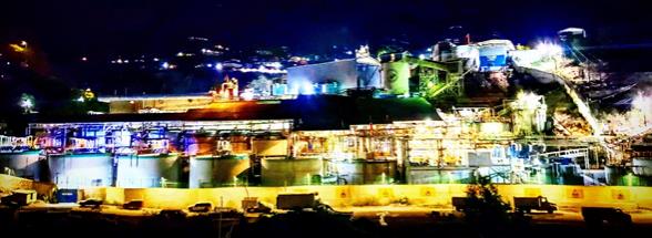
airport, the Tayoltita mill crushing and processing facilities, the Tayoltita/Cupias dry-stack tailings facilities, the Las Truchas hydroelectric generation facilities, four LNG 1 MW generators recently installed in 2025, and a backup portable diesel power generation site. The main administrative offices and employee houses, the warehouses, assay laboratory, core shack and other facilities are located in Tayoltita.
San Dimas is located in the central part of the Sierra Madre Occidental, a mountain range characterized by rugged topography with steep, often vertical, walled valleys, and narrow canyons. Elevations vary from 2,400 metres above mean sea level (masl) on the high peaks to elevations of 400 masl in the valley floor of the Piaxtla River.
| 1.3. | History |
The San Dimas property contains a series of epithermal gold silver veins that have been mined intermittently since 1757. Modern mining began in the 1880s, by the American-owned San Luis Mining Company and the Mexican-owned Candelaria Company.
In 1961, Minas de San Luis, a company owned by Mexican interests, acquired 51% of the San Dimas group of properties and assumed operations of the mine. In 1978, the remaining 49% interest in the mine was obtained by Luismin S.A. de C.V (Luismin). In 2002, Wheaton River Minerals Ltd. (Wheaton River) acquired the property from Luismin and in 2005 Wheaton River merged with Goldcorp Inc. (Goldcorp). Under its prior name Mala Noche Inc., Primero Mining Corp. (Primero) acquired San Dimas from subsidiaries of Goldcorp in August 2010. In May 2018, First Majestic acquired 100% interest in San Dimas property through acquisition of Primero.
Historical production through December 2024 from San Dimas is estimated at more than 766 Moz of silver and more than 11.1 Moz of gold, placing the district third in Mexico for precious metal production after Pachuca and Guanajuato. The majority of this production was prior to First Majestic’s acquisition of the property. The average production rate by First Majestic during 2019–2024 was approximately 2,100 tonnes per day (tpd).
| 1.4. | Geological Setting, Mineralization and Deposit Types |
The San Dimas property is located in the central part of the Sierra Madre Occidental (SMO), near the Sinaloa-Durango state border, which has an average elevation exceeding 2000 m above sea level, extending from the Mexico-US border to the Trans-Mexican Volcanic Belt. Numerous epithermal deposits have been found along the SMO.
The SMO consists of Late Cretaceous to early Miocene igneous rocks including two major volcanic successions totalling approximately 3,500 m in thickness and are separated by erosional and depositional unconformities: the Lower Volcanic Complex (LVC) and Upper Volcanic Group (UVG).
| 3 | September 2025 |
| San Dimas Silver/Gold Mine Durango and Sinaloa States, Mexico NI-43-101 Technical Report on Mineral Resource and Mineral Reserve Estimates |
|
The LVC consists of predominantly intermediate volcanic and intrusive rocks formed between approximately 100 and 50 Ma. The LVC has traditionally been divided into local geological units based on field observations. The lower part of the sequence consists of the more than 700 m thick Socavón rhyolite, which is host to several productive veins in the district. This overlain by the Buelna andesite and the Portal Rhyolite which range from 50-250 m in thickness.
The lower sequence of rhyolitic rocks is unconformably overlain by a succession of andesitic lava flows and volcanogenic sedimentary rocks including the Productive Andesite (> 750 m thick), Las Palmas rhyo-andesite tuffs and flows (>300 m thick), and the volcanogenic sedimentary unit the Camichin Unit.
The UVG sits unconformably on the LVC and consists of the lower Guarisamey andesite and the Capping Rhyolite. The Capping Rhyolite consists of rhyolitic ash flows and air-fall tuffs and may reach as much as 1,500 m in thickness in the eastern part of the district.
The LVC and UVG volcanic rocks are intruded by intermediate rocks, consisting of the Arana intrusive andesite and the Arana intrusive diorite, and a felsic suite comprising the Piaxtla granite and the Santa Lucia, Bolaños, and Santa Rita dikes. The basic dikes intrude both the LVC and the UVG.
The most prominent structures are major north–northwest-trending normal faults with opposite vergence that divide the district into five fault-bounded blocks that are tilted to the east–northeast or west–northwest. East–west to west–southwest–east–northeast striking fractures, perpendicular to the major normal faults, are often filled by quartz veins, dacite porphyry dikes, and pebble dikes. The veins are generally west–southwest–east-northeast-oriented, within a corridor approximately 10 km wide. The veins are often truncated by the north–northwest–south–southeast-trending major faults, separating the original veins into segments. These segments are named as individual veins and grouped within the mine zones by fault block.
The mine zone groupings of veins are, from west to east: West Block, Graben Block, Central Block, Tayoltita Block, Alto de Arana Block (also known as Arana HW), San Vicente, El Cristo and Santa Rita.
Three deformational events are related to the development of the major faults, hydrothermal veins, and dikes.
Within the San Dimas property, the mineralization is typical of epithermal vein structures with banded and drusy textures. Epithermal-style veins occupy east–west-trending fractures, except in the southern part of the Tayoltita Block where they strike mainly northeast, and in the Santa Rita area where they strike north–northwest. The metal rich stage consists primarily of white to light grey, medium-to-coarse-grained crystalline quartz. The quartz contains intergrowths of base metal sulphides (sphalerite, chalcopyrite, and galena) as well as pyrite, argentite, polybasite, stromeyerite, native silver, and electrum.
Mine geologists observed that bonanza grades along the San Luis vein in the Tayoltita Block were spatially related to the Productive andesite unit and/or to the interface between the Productive andesite and the Portal rhyolite and/or the Buelna andesite. This spatial association of vein-hosted mineralization with a
| 4 | September 2025 |
| San Dimas Silver/Gold Mine Durango and Sinaloa States, Mexico NI-43-101 Technical Report on Mineral Resource and Mineral Reserve Estimates |
|
favorable host-rock zone within the volcanic sequence is now recognized in other fault blocks and constitutes a major exploration criterion for the district.
More than 125 mineralized quartz veins have been recognized across the San Dimas property. The silver and gold rich quartz veins have been followed underground from a few metres in strike-length to more than 1,500 m. One of these veins, the Jessica Vein, extends for more than 1,000 m in the Central Block. The vein-hosted mineral deposits within the San Dimas district are considered to be examples of silver- and gold-bearing epithermal quartz veins that formed in a low-sulphidation setting.
| 1.5. | Exploration |
The San Dimas property has been the subject of modern exploration and mine development activities since the early 1970s, and a considerable information database has been developed from both exploration and mining activities. Exploration uses information from surface and underground mapping, sampling, and drilling together with extensive underground mine tunneling to help identify targets. Other exploration activities include prospecting, geochemical surface sampling, geophysical, predictive artificial intelligence, and remote sensing surveys.
Most of the exploration activities carried out within the San Dimas property were centered around the Piaxtla River where exposures of silver–gold veins were found. Outside of this area, the Lechuguilla and Ventana areas were explored to some extent during 2008 and 2015–16. The remainder of the property had limited exploration due to post-mineral cover by a thick layer of ignimbrites.
The exploration potential remains open in the areas surrounding the mine zones. As the mine was developed to the north, new veins were found. South of the Piaxtla River, the El Cristo area has potential for new quartz vein discoveries. The West Block is currently being explored by drilling and tunnelling. Opportunities to intercept the projection of fault-offset quartz veins from the Graben Block are considered good.
| 1.6. | Drilling |
Drilling in the San Dimas property is focused on the identification and delineation of vein-hosted silver and gold resources by using structural and stratigraphic knowledge of the district, and preferred vein trends. Since the “favourable horizon” for mineral deposits concept emerged in 1975, the exploration drilling strategy has focused on core drilling perpendicular to the preferred vein orientation within the mine zones, which has proven to be the most effective method of exploration in the area. Core drilling is predominantly done from underground stations, as the rugged topography and the great drilling distance from surface locations to the target(s) makes surface drilling challenging and expensive. Over 1,413,000 m of core drilling has been completed since 2000.
| 5 | September 2025 |
| San Dimas Silver/Gold Mine Durango and Sinaloa States, Mexico NI-43-101 Technical Report on Mineral Resource and Mineral Reserve Estimates |
|
| 1.7. | Sampling, Analysis and Data Verification |
Diamond drill core is delivered to the core logging facility where San Dimas geologists select and mark sample intervals according to lithological contacts, mineralization, alteration, and structural features.
Drill core intervals selected for sampling are cut in half using a diamond saw. One half of the core is retained in the core box for further inspection and the other half is placed in a sample bag. For smaller diameter delineation drill core (TT-46) “termite” the entire core is sampled for analysis.
The sample number is printed with a marker on the core box beside the sampled interval, and a sample tag is inserted into the sample bag. Sample bags are tied with string and placed in rice bags for shipping.
Since 2013, underground mine production channel samples for ore control and channel samples for resource estimation have been collected at San Dimas. Earlier channel samples were taken either across the roof of developments or across the face in developments. From 2016 to present, production channel samples for ore control and channel samples for resource estimation are routinely taken across the mine development face and within stopes.
Bulk density measurements are systematically taken on drill core. From 2016 to 2023, specific gravity measurements were collected on 10 cm or longer whole core vein samples using the unsealed water immersion method. Based on this method, an average bulk density value of 2.6 t/m3 was determined.
Quality control samples such as duplicates, checks and standards are included with all samples.
Since 2004, four different laboratories have been used for sample preparation and analysis. These include, First Majestic’s San Dimas Laboratory, SGS Durango, ALS-Chemex Zacatecas, and First Majestic’s ISO9001 certified Central Lab facility located at the Company’s Santa Elena operation in Sonora, Mexico.
Channel samples and drill core samples were dried, crushed, and pulverized.
In general, samples were analyzed for gold by a 30 g FA atomic absorption spectroscopy (AAS) method. Silver was analyzed by a 2 g, three-acid digestion AAS method. A multi-element suite was analyzed by a 0.25 g, aqua regia digestion inductively coupled plasma (ICP) optical emission spectroscopy (OES) method.
From 2013 to 2018, the QAQC program for the San Dimas laboratory samples included insertion of a standard reference material (SRM) and a blank in every batch of 20 samples. From 2013 to 2018, the QAQC program for channel and core samples included insertion of a SRM and a blank in every batch of 20 samples. In 2013, 5% of the coarse reject and pulp duplicates from core samples were randomly selected for analysis at SGS Durango and 5% of pulp checks from core samples were analyzed at ALS laboratory. Since 2022, the QAQC samples inserted in the core sampling include field, coarse reject, and pulp duplicates, CRMs, and coarse and pulp blanks.
The data verification included data entry error checks, visual inspections of data, and a review of QA/QC assay results was completed. Several site visits were completed as part of the data verification process. No significant differences were observed.
| 6 | September 2025 |
| San Dimas Silver/Gold Mine Durango and Sinaloa States, Mexico NI-43-101 Technical Report on Mineral Resource and Mineral Reserve Estimates |
|
| 1.8. | Mineral Processing and Metallurgical Testing |
San Dimas operation is made up of several operating underground mines within the property boundaries, which all feed a central milling operation. The metallurgical test work data used to support the initial plant design has been consistently validated and reinforced by years of operational results, complemented by more recent metallurgical studies. Metallurgical testing and mineralogical investigations are routinely conducted to support ongoing performance optimization. The plant continuously performs tests to optimize metal recoveries and reduce operating costs, even when current performance falls within expected parameters. This test work is conducted by the on-site metallurgical laboratory.
The metallurgical recovery projections outlined in the LOM plan are supported by the historical performance of the processing plant and metallurgical testing of future ore. Based on plant performance data from 2021 to 2024, the estimated metal recoveries for the LOM plan and financial analysis are 92.6% for silver and 95.6% for gold. The last two years (2023 and 2024) were used in the LOM based on future material type and corresponding metallurgical testing. San Dimas doré consistently exceeds 97% purity (Au + Ag) and incurs no refinery penalties. Since March 2023, purity has surpassed 98% due to process improvements, including higher-purity zinc powder and optimized flux blends.
| 1.9. | Mineral Resource and Mineral Reserve Estimates |
| 1.9.1. | Mineral Resource Estimates |
The geological modelling, data analysis, and block model Mineral Resource estimates for San Dimas were completed under the supervision of David Rowe, CPG, a First Majestic employee.
The block model Mineral Resource estimates are based on the database of exploration drill holes and production channel samples, underground level geological mapping, geological interpretations and models, as well as surface topography and underground mining development wireframes available as of the December 31, 2024, cut-off date for scientific and technical data supporting the estimates.
Exploratory data analysis was completed for gold and silver assay sample values to assess the statistical and spatial character of the sample data. Boundary analysis was completed to review the change in metal grade across the domain contacts Hard boundaries were used during the creation of composite samples during mineral resource estimation.
To assess the statistical character of the composite samples within each of domains, data were declustered to account for over-sampling in certain regions. The selected composite sample length varied by domain with the most common composite sample length being 1.0 m. The assay sample intervals were composited within the limits of the domain boundaries and then tagged with the appropriate domain code. Drill hole and channel composite samples were evaluated for high-grade outliers and those outliers were capped to values considered appropriate for each domain.
| 7 | September 2025 |
| San Dimas Silver/Gold Mine Durango and Sinaloa States, Mexico NI-43-101 Technical Report on Mineral Resource and Mineral Reserve Estimates |
|
Mineral Resources were estimated into sub-block models rotated parallel to the resource domain trend. Parent block grades were estimated using inverse distance weighting interpolation. The block estimates were made with multiple passes to limit the influence the channel production samples at longer ranges. Pass 1 was a restrictive short-range pass that used channel and drill hole composite samples, and subsequent less restrictive passes used drill hole samples only. An average bulk density value of 2.6 t/m3 was used in estimation for all resource domains.
Validation was completed for each of the resource estimation domains in multiple steps including visual inspection, global grade bias checks, and swath plots. Overall, the block model validations demonstrated that the current Mineral Resource estimates are a reasonable representation of the primary input sample data. The Mineral Resource estimates were classified into Measured, Indicated, or Inferred based on the confidence in the geological interpretation and models, the confidence in the continuity of metal grades, the sample support for the estimation and reliability of the sample data, and on the presence of underground mining development providing detailed mapping and production channel sample support.
The Mineral Resource estimates were evaluated for reasonable prospects for eventual economic extraction by application of input parameters based on mining and processing information from the last 2 years of operations. Deswik Stope Optimizer software was used to identify the blocks representing mineable volumes that exceed the cut-off value while complying with the aggregate of economic parameters.
The Mineral Resource estimates for San Dimas are summarized in
| 8 | September 2025 |
| San Dimas Silver/Gold Mine Durango and Sinaloa States, Mexico NI-43-101 Technical Report on Mineral Resource and Mineral Reserve Estimates |
|
Table 1-1 and Table 1-2 using a Net Smelter Return (NSR) cut-off value of $174/t. Measured and Indicated Mineral Resources are reported inclusive of Mineral Reserves and have an effective date of December 31, 2024. Mineral Resources that are not Mineral Reserves do not have demonstrated economic viability.
| 9 | September 2025 |
| San Dimas Silver/Gold Mine Durango and Sinaloa States, Mexico NI-43-101 Technical Report on Mineral Resource and Mineral Reserve Estimates |
|
Table 1-1: San Dimas Measured and Indicated Mineral Resource Estimate
(effective date December 31, 2024)
| Category / Area |
Mineral Type |
Tonnage |
Grades | Metal Content | ||||||||||||||||||||||||||
| k tonnes |
Ag (g/t) |
Au (g/t) |
Ag-Eq (g/t) |
Ag (k Oz) |
Au (k Oz) |
Ag-Eq (k Oz) |
||||||||||||||||||||||||
| Measured Central Block |
Sulphides | 1,169 | 355 | 4.79 | 778 | 13,320 | 180 | 29,240 | ||||||||||||||||||||||
| Measured Sinaloa Graben |
Sulphides | 478 | 360 | 4.84 | 789 | 5,540 | 74 | 12,120 | ||||||||||||||||||||||
| Measured Other Areas |
Sulphides | 205 | 399 | 3.80 | 735 | 2,630 | 25 | 4,850 | ||||||||||||||||||||||
|
|
|
|
|
|
|
|
|
|
|
|
|
|
|
|||||||||||||||||
| Total Measured |
Sulphides | 1,851 | 361 | 4.69 | 776 | 21,490 | 279 | 46,210 | ||||||||||||||||||||||
|
|
|
|
|
|
|
|
|
|
|
|
|
|
|
|||||||||||||||||
| Indicated Central Block |
Sulphides | 1,326 | 248 | 2.79 | 494 | 10,550 | 119 | 21,070 | ||||||||||||||||||||||
| Indicated Sinaloa Graben |
Sulphides | 543 | 245 | 3.07 | 517 | 4,280 | 54 | 9,030 | ||||||||||||||||||||||
| Indicated Tayoltita |
Sulphides | 158 | 326 | 4.04 | 684 | 1,660 | 21 | 3,480 | ||||||||||||||||||||||
| Indicated Other Areas |
Sulphides | 997 | 335 | 3.00 | 600 | 10,730 | 96 | 19,240 | ||||||||||||||||||||||
|
|
|
|
|
|
|
|
|
|
|
|
|
|
|
|||||||||||||||||
| Total Indicated |
Sulphides | 3,025 | 280 | 2.97 | 543 | 27,220 | 289 | 52,820 | ||||||||||||||||||||||
|
|
|
|
|
|
|
|
|
|
|
|
|
|
|
|||||||||||||||||
| M+I Central Block |
Sulphides | 2,494 | 298 | 3.72 | 627 | 23,870 | 299 | 50,300 | ||||||||||||||||||||||
| M+I Sinaloa Graben |
Sulphides | 1,021 | 299 | 3.90 | 645 | 9,820 | 128 | 21,160 | ||||||||||||||||||||||
| M+I Tayoltita |
Sulphides | 158 | 326 | 4.04 | 684 | 1,660 | 21 | 3,480 | ||||||||||||||||||||||
| M+I Other Areas |
Sulphides | 1,202 | 346 | 3.14 | 623 | 13,360 | 121 | 24,080 | ||||||||||||||||||||||
|
|
|
|
|
|
|
|
|
|
|
|
|
|
|
|||||||||||||||||
| Total M+I |
Sulphides | 4,876 | 311 | 3.63 | 632 | 48,710 | 569 | 99,020 | ||||||||||||||||||||||
|
|
|
|
|
|
|
|
|
|
|
|
|
|
|
|||||||||||||||||
Table 1-2: San Dimas Inferred Mineral Resource Estimate (effective date December 31, 2024)
| Category / Area |
Mineral Type |
Tonnage |
Grades | Metal Content | ||||||||||||||||||||||||||
|
|
k tonnes |
Ag (g/t) |
Au (g/t) |
Ag-Eq (g/t) |
Ag (k Oz) |
Au (k Oz) |
Ag-Eq (k Oz) |
|||||||||||||||||||||||
| Inferred Central Block |
Sulphides | 1,897 | 251 | 3.02 | 518 | 15,330 | 184 | 31,610 | ||||||||||||||||||||||
| Inferred Sinaloa Graben |
Sulphides | 526 | 382 | 5.20 | 842 | 6,470 | 88 | 14,260 | ||||||||||||||||||||||
| Inferred Tayoltita |
Sulphides | 506 | 261 | 3.10 | 536 | 4,250 | 50 | 8,710 | ||||||||||||||||||||||
| Inferred Other Areas |
Sulphides | 2,400 | 217 | 2.24 | 415 | 16,760 | 173 | 32,050 | ||||||||||||||||||||||
|
|
|
|
|
|
|
|
|
|
|
|
|
|
|
|||||||||||||||||
| Total Inferred |
Sulphides | 5,329 | 250 | 2.89 | 506 | 42,810 | 495 | 86,630 | ||||||||||||||||||||||
|
|
|
|
|
|
|
|
|
|
|
|
|
|
|
|||||||||||||||||
| (1) | Mineral Resource estimates are classified per CIM Definition Standards (2014) and NI 43-101. |
| (2) | Mineral Resource estimates are based on internal estimates with an effective date of December 31, 2024. |
| (3) | Mineral Resource estimates were supervised or reviewed by David Rowe, CPG, Internal Qualified Person for First Majestic, per NI 43-101. |
| (4) | Silver-equivalent grade (Ag-Eq) is calculated as follows: |
Ag-Eq = Ag Grade + (Au Grade x Au Recovery x Au Payable x Au Price) / (Ag Recovery x Ag Payable x Ag Price).
| (5) | Metal prices for Mineral Resources estimates were $28.0/oz Ag and $2,400/oz Au. Metallurgical recovery used was 92.6% for silver and 95.6% for gold. Metal payable used was 99.95% for silver and gold. |
| (6) | NSR cutoff value considered to constrain resources assumed an underground operation was $174/t and was based on actual and budgeted operating and sustaining costs. |
| (7) | Mineral Resources are reported within mineable stope shapes using the NSR cutoff value calculated using the stated metal prices and metal recoveries. The NSR cutoff includes mill recoveries and payable metal factors appropriate to the existing processing circuit. |
| (8) | No dilution was applied to the Mineral Resource which are reported on an in-situ basis. |
| (9) | Tonnage is expressed in thousands of tonnes; metal content is expressed in thousands of ounces. Totals may not add up due to rounding. |
| 10 | September 2025 |
| San Dimas Silver/Gold Mine Durango and Sinaloa States, Mexico NI-43-101 Technical Report on Mineral Resource and Mineral Reserve Estimates |
|
| (10) | Measured and Indicated Mineral Resources are reported inclusive of Mineral Reserves. Mineral Resources that are not Mineral Reserves do not have demonstrated economic viability. |
Risk factors that may materially impact the Mineral Resource estimates include: changes to the assumptions used to generate the NSR cut-off value including metal price and exchange rates; changes to interpretations of mineralization geometry and continuity; changes to geotechnical, mining, and metallurgical recovery assumptions; assumptions as to the continued ability to access the site, retain mineral and surface rights titles, maintain environment and other regulatory permits, and maintain the social license to operate.
| 1.9.2. | Mineral Reserve Estimates |
The Mineral Reserves estimation process consists of converting Mineral Resources into Mineral Reserves by identifying material that exceeds the mining cut-off grades and conforms to the geometrical constraints defined by the selected mining method. Modifying factors, such as mining methods, mining recovery, dilution, sterilization, depletion, cutoff grades, geotechnical conditions, metallurgical factors, infrastructure, operability, safety, environmental, regulatory, saleability of products, social and legal factors. These factors were applied to produce mineable stope shapes. If the Mineral Resources comply with the previous constraints, Measured Resources could be converted to Proven Reserves and Indicated Resources could be converted to Probable Reserves, in some instances Measured Resources could be converted to Probable Reserves if any or more of the modifying factors reduces the confidence of the estimates.
The NSR is the variable that was used as indicator to segregate if the revenue from the mineralized material in a block, which is part of the Measured and Indicated Mineral Resources, exceeds the operating and capital costs. NSR formulas were derived from the assumed economic parameters shown in
Table 1-3.
Table 1-3: Economic Parameters assumed for calculation of NSR
| Concept |
Units | Values | ||||
| Metal Price Ag |
$/oz Ag | 26.00 | ||||
| Metal Price Au |
$/oz Au | 2,200 | ||||
| Metallurgical Recovery Ag |
% | 92.60 | ||||
| Metallurgical Recovery Au |
% | 95.60 | ||||
| Metal Payable Ag and Au |
% | 99.95 | ||||
| Dore Transport Cost |
$/oz Dore | 0.166 | ||||
| Insurance and Representation Cost |
$/oz Dore | 0.046 | ||||
| Refining Change Ag |
$/oz Ag | 0.225 | ||||
| Refining Change Au |
$/oz Au | 0.500 | ||||
Three types of cut-off values (COV) have been determined for San Dimas: general COV, incremental COV, and marginal COV. The COVs are expressed in $/tonne, reflecting the value that the run-of-mine (ROM) material will carry before is fed to the processing plant.
| 11 | September 2025 |
| San Dimas Silver/Gold Mine Durango and Sinaloa States, Mexico NI-43-101 Technical Report on Mineral Resource and Mineral Reserve Estimates |
|
The planned dilution assumes a minimum mining width, which will depend on the applied mining method. The minimum mining width for cut-and-fill using jackleg drills was 0.8 m, while when using jumbo drills was 3.5 m. In the case of longhole mining, the minimum mining width assumed was 1.2 m.
The estimated overbreak in each side of the designed stope is 0.2 m for the two mining methods, longhole and cut-and-fill. An extra dilution from the backfill floor of 0.3 m for longhole and 0.2 m for cut-and-fill is also assumed. The unplanned dilution assumed was an additional 8% of the extracted material before becoming plant-feed.
Other than for sill mining, average mining loss throughout each mining block for both cut-and-fill and longhole mining has been assumed to be 5%. A factor of 25% has been used for sill pillars.
San Dimas Mineral Reserves are presented in Table 1-4.
| 12 | September 2025 |
| San Dimas Silver/Gold Mine Durango and Sinaloa States, Mexico NI-43-101 Technical Report on Mineral Resource and Mineral Reserve Estimates |
|
Table 1-4: San Dimas Mineral Reserves Statement (Effective Date December 31, 2024)
| Category / Area |
Mineral Type |
Tonnage |
Grades | Metal Content | ||||||||||||||||||||||||||
| k tonnes |
Ag (g/t) |
Au (g/t) |
Ag-Eq (g/t) |
Ag (k Oz) |
Au (k Oz) |
Ag-Eq (k Oz) |
||||||||||||||||||||||||
| Proven Central Block |
Sulphides | 780 | 255 | 3.47 | 557 | 6,390 | 87 | 13,980 | ||||||||||||||||||||||
| Proven Sinaloa Graben |
Sulphides | 293 | 222 | 2.67 | 455 | 2,090 | 25 | 4,290 | ||||||||||||||||||||||
| Proven Tayoltita |
Sulphides | 0 | 0 | 0.00 | 0 | 0 | 0 | 0 | ||||||||||||||||||||||
| Proven Other Areas |
Sulphides | 184 | 297 | 2.65 | 528 | 1,750 | 16 | 3,120 | ||||||||||||||||||||||
|
|
|
|
|
|
|
|
|
|
|
|
|
|
|
|||||||||||||||||
| Total Proven |
Sulphides | 1,257 | 253 | 3.16 | 529 | 10,230 | 128 | 21,390 | ||||||||||||||||||||||
|
|
|
|
|
|
|
|
|
|
|
|
|
|
|
|||||||||||||||||
| Probable Central Block |
Sulphides | 732 | 228 | 2.74 | 467 | 5,370 | 65 | 11,010 | ||||||||||||||||||||||
| Probable Sinaloa Graben |
Sulphides | 381 | 211 | 2.66 | 443 | 2,580 | 33 | 5,430 | ||||||||||||||||||||||
| Probable Tayoltita |
Sulphides | 133 | 206 | 2.74 | 445 | 880 | 12 | 1,900 | ||||||||||||||||||||||
| Probable Other Areas |
Sulphides | 726 | 275 | 2.48 | 492 | 6,420 | 58 | 11,470 | ||||||||||||||||||||||
|
|
|
|
|
|
|
|
|
|
|
|
|
|
|
|||||||||||||||||
| Total Probable |
Sulphides | 1,972 | 241 | 2.63 | 470 | 15,250 | 167 | 29,810 | ||||||||||||||||||||||
|
|
|
|
|
|
|
|
|
|
|
|
|
|
|
|||||||||||||||||
| P+P Central Block |
Sulphides | 1,512 | 242 | 3.11 | 514 | 11,760 | 151 | 24,990 | ||||||||||||||||||||||
| P+P Sinaloa Graben |
Sulphides | 674 | 216 | 2.67 | 448 | 4,670 | 58 | 9,720 | ||||||||||||||||||||||
| P+P Tayoltita |
Sulphides | 133 | 206 | 2.74 | 445 | 880 | 12 | 1,900 | ||||||||||||||||||||||
| P+P Other Areas |
Sulphides | 910 | 279 | 2.51 | 499 | 8,170 | 74 | 14,590 | ||||||||||||||||||||||
|
|
|
|
|
|
|
|
|
|
|
|
|
|
|
|||||||||||||||||
| Total P+P |
Sulphides | 3,229 | 245 | 2.84 | 493 | 25,480 | 294 | 51,200 | ||||||||||||||||||||||
|
|
|
|
|
|
|
|
|
|
|
|
|
|
|
|||||||||||||||||
| (1) | Mineral Reserves are classified per CIM Definition Standards (2014) and NI 43-101. |
| (2) | Mineral Reserves are effective December 31, 2024, are derived from Measured & Indicated Resources, account for depletion to that date, and are reported with a reference point of mined ore delivered to the plant. |
| (3) | Mineral Reserve estimates were supervised or reviewed by Andrew Pocock, P.Eng., Internal Qualified Person for First Majestic per NI 43-101. |
| (4) | Silver-equivalent grade (Ag-Eq) is calculated as follows: |
Ag-Eq Grade = Ag Grade + Au Grade *(Au Recovery * Au Payable * Au Price) / (Ag Recovery * Ag Payable * Ag Price)
| (5) | Metal prices for Reserves: $26/oz Ag, $2,200/oz Au. Other key assumptions and parameters include Metallurgical recoveries of 92.6% Ag, 95.6% Au; metal payable of 99.95% Ag & Au, costs ($/t): direct mining $61.91 longhole stoping and $96.55 cut & fill, processing $39.37 mill feed, indirect/G&A $65.51 and sustaining $35.88 for longhole stoping and cut & fill. |
| (6) | A two-step cutoff approach was used per mining method: A general cutoff grade defines mining areas covering all associated costs; and a 2nd pass incremental cutoff includes adjacent material covering only its own costs, excluding shared general development access & infrastructure costs which are covered by the general cutoff material. |
| (7) | Modifying factors for conversion of resources to reserves include but are not limited to consideration for mining methods, mining recovery, dilution, sterilization, depletion, cutoff grades, geotechnical conditions, metallurgical factors, infrastructure, operability, safety, environmental, regulatory, social, and legal factors. These factors were applied to produce mineable stope shapes. |
| (8) | Tonnage in thousands of tonnes, metal content in thousands of ounces, prices/costs in USD. Numbers are rounded per guidelines; totals may not sum due to rounding. |
The QP is not aware of any known mining, metallurgical, environmental, permitting, legal, title, taxation, socio-economic, marketing, political, or other relevant factors that could materially affect the Mineral Reserve estimates, other than discussed herein.
| 13 | September 2025 |
| San Dimas Silver/Gold Mine Durango and Sinaloa States, Mexico NI-43-101 Technical Report on Mineral Resource and Mineral Reserve Estimates |
|
| 1.10. | Mining Operations |
San Dimas includes five underground gold and silver mining areas: West Block (San Antonio, Perez mine), Sinaloa Graben Block (Graben Block), Central Block, Tayoltita Block, and the Arana Hanging-wall Block (Santa Rita mine).
Both First Majestic and contractor personnel conduct mining activities. Two mining methods are currently being used at San Dimas, cut-and-fill, and Longhole mining. Cut-and-fill is carried out by either jumbo or jackleg drills, whereas Longhole is carried out with pneumatic and electro-hydraulic drills. Primary access is provided by adits and internal ramps.
Ground conditions throughout most of the San Dimas underground workings are considered good. Bolting is used systematically in the main haulage ramps, drifts, and underground infrastructure. For those sectors that present unfavorable rock quality, shotcrete, mesh, and/or steel arches are used.
Groundwater inflow has not been a significant concern within San Dimas. Dewatering systems in San Dimas consist of main and auxiliary pumps in place at each of the mine areas.
The San Dimas ventilation system consists of an exhaust air extraction system through its main fans located on surface. These fans generate the necessary pressure change for fresh air to enter through the portals and ventilation raises.
The development schedule for the LOM plan is presented in Table 1-5. The production schedule for the LOM plan is presented in
| 14 | September 2025 |
| San Dimas Silver/Gold Mine Durango and Sinaloa States, Mexico NI-43-101 Technical Report on Mineral Resource and Mineral Reserve Estimates |
|
Table 1-6.
Table 1-5 San Dimas Life of Mine Development Schedule
| Type |
Units | Size (m) | 2025 | 2026 | 2027 | 2028 | 2029 | Total | ||||||||||||||||||||
| Main Access Ramp |
m | 4.5x4.5 | 2,378 | 2,385 | 2,385 | 2,578 | 586 | 10,313 | ||||||||||||||||||||
| Main Level Access |
m | 4.5x4.5 | 2,101 | 2,107 | 2,107 | 2,277 | 518 | 9,109 | ||||||||||||||||||||
| Ancillary |
m | 3.5x3.5 | 1,229 | 1,232 | 1,232 | 1,332 | 303 | 5,328 | ||||||||||||||||||||
| Drifting for Exploration |
m | 4.5x4.5 | 1,821 | 1,826 | 1,826 | 2,016 | 469 | 7,958 | ||||||||||||||||||||
| Ventilation Raises |
m | 2.5 diam | 1,009 | 1,067 | 580 | 446 | 51 | 3,153 | ||||||||||||||||||||
|
|
|
|
|
|
|
|
|
|
|
|
|
|||||||||||||||||
| Total Waste Development |
m | 8,538 | 8,617 | 8,130 | 8,649 | 1,926 | 35,860 | |||||||||||||||||||||
| Ore Development |
m | 3.5x3.5 | 6,783 | 6,802 | 6,802 | 6,326 | 3,353 | 30,066 | ||||||||||||||||||||
|
|
|
|
|
|
|
|
|
|
|
|
|
|||||||||||||||||
| Total Development |
m | 15,321 | 15,418 | 14,932 | 14,975 | 5,279 | 65,926 | |||||||||||||||||||||
|
|
|
|
|
|
|
|
|
|
|
|
|
|||||||||||||||||
| 15 | September 2025 |
| San Dimas Silver/Gold Mine Durango and Sinaloa States, Mexico NI-43-101 Technical Report on Mineral Resource and Mineral Reserve Estimates |
|
Table 1-6 San Dimas Life of Mine Production Schedule
| Type |
Units | 2025 | 2026 | 2027 | 2028 | 2029 | Total | |||||||||||||||||||
| ROM Production / Plant Feed |
kt | 629 | 631 | 631 | 630 | 708 | 3,229 | |||||||||||||||||||
| Silver Grade |
g/t Ag | 285 | 285 | 285 | 230 | 153 | 245 | |||||||||||||||||||
| Gold Grade |
g/t Au | 2.83 | 2.83 | 2.83 | 2.83 | 2.86 | 2.84 | |||||||||||||||||||
| Silver-Equivalent Grade |
g/t Ag-Eq | 532 | 532 | 532 | 477 | 403 | 493 | |||||||||||||||||||
| Contained Silver |
M oz Ag | 5.8 | 5.8 | 5.8 | 4.7 | 3.5 | 25 | |||||||||||||||||||
| Contained Gold |
k oz Au | 57 | 57 | 57 | 57 | 65 | 294 | |||||||||||||||||||
| Contained Silver-Equivalent |
M oz Ag-Eq | 10.8 | 10.8 | 10.8 | 9.7 | 9.2 | 51 | |||||||||||||||||||
| Metallurgical Recovery Silver |
% | 94.9 | % | 92.6 | % | 92.6 | % | 92.6 | % | 92.6 | % | 93.1 | % | |||||||||||||
| Metallurgical Recovery Gold |
% | 95.1 | % | 95.6 | % | 95.6 | % | 95.6 | % | 95.6 | % | 95.5 | % | |||||||||||||
| Produced Silver |
M oz Ag | 5.5 | 5.4 | 5.4 | 4.3 | 3.2 | 24 | |||||||||||||||||||
| Produced Gold |
k oz Au | 54 | 55 | 55 | 55 | 62 | 281 | |||||||||||||||||||
| Produced Silver-Equivalent |
M oz Ag-Eq | 10.2 | 10.1 | 10.1 | 9.1 | 8.7 | 48 | |||||||||||||||||||
A total of 3.2 Mt of ore is considered to be mined and processed with grades of 245 g/t Ag and 2.84 g/t Au. Total metal produced is estimated at 25 Moz Ag and 294 Koz Au.
| 1.11. | Recovery Methods |
The San Dimas processing plant has been in successful operation for several years, consistently achieving high recoveries based on both historical performance and recent metallurgical testing. The plant operates on a conventional cyanide leaching and Merrill-Crowe process to produce silver-gold doré bars, with an installed capacity of 3,000 tpd.
The facility is designed as a single processing train, with the crushing area separated from the rest of the circuit and connected via a belt conveyor that transfers screened material to the fine-ore bins. The plant consists of the following operating units: a two-stage crushing circuit with a primary jaw crusher and a secondary cone crusher (one in operation, one standby) in closed circuit with a double-deck 8’x16’ dry vibrating screen; three ball mills operating in parallel, each with two hydrocyclones (one operational, one standby) in closed circuit; cyanide leaching in 16 agitated tanks with two intermediate thickeners; two counter-current decantation (CCD) thickeners in series; Merrill-Crowe zinc precipitation followed by smelting; and four horizontal vacuum belt filters for tailings filtration, located adjacent to the Tailings Storage Facility. This robust configuration supports high metallurgical performance and operational efficiency across the circuit.
| 1.12. | Infrastructure, Permitting and Compliance Activities |
The infrastructure in San Dimas is fully developed to support current mining and mineral processing activities, with part of its facilities located in the town of Tayoltita.
The main infrastructure of San Dimas consists of access roads, the district mines, which are divided into five mining areas, crushing and processing facilities known as the Tayoltita mill, the Tayoltita/Cupias tailings facilities, an assays laboratory, offices and staff camp, the Las Truchas hydroelectric generation
| 16 | September 2025 |
| San Dimas Silver/Gold Mine Durango and Sinaloa States, Mexico NI-43-101 Technical Report on Mineral Resource and Mineral Reserve Estimates |
|
facilities, an LNG and diesel-powered emergency generation plant, a local airport and infrastructure supporting the inhabitants of the Tayoltita townsite including a local clinic, schools and sport facilities.
Most of the personnel and light supplies for San Dimas arrive on First Majestic’s regular flights from Mazatlán and Durango. Heavy equipment and other supplies are brought by road from Durango and Mazatlán.
Electrical power is provided by a combination of First Majestic’s own hydroelectric generation system (Las Truchas) and the Federal Power Commission supply system (CFE). First Majestic operates the hydroelectric generation plant, which is interconnected with the CFE power grid, and a series of back-up diesel generators which are being replaced by an LNG plant in 2025.
The source of water for industrial use comes mainly from mine dewatering stations and from the recycled filtered-tailings water after it has been treated. About 80% of the water required for processing activities is being treated and recycled. A project to improve water sourcing and reliability is under review and consideration for H2 2025 completion.
Environmental and social studies are routinely performed in San Dimas to characterize existing conditions and to support the preparation of Risk Assessments and Accident Prevention Programs for the operation and are documented as part of the Environmental Management System implemented by First Majestic.
San Dimas consists of several mining areas, and it holds major environmental permits and licenses required by the Mexican authorities to carry out mineral extracting activities in the mining complex.
The main environmental permit is the environmental license “Licencia Ambiental Unica” (LAU) under which the mine operates its industrial facilities in accordance with the Mexican environmental protection laws administered by SEMARNAT as the agency in charge of environment and natural resources. The most recent update to the main environmental permit was approved in April 2024.
On May 8, 2023, the Mexican Government enacted a decree amending several provisions of the Mining Law, the Law on National Waters, the Law on Ecological Equilibrium and Environmental Protection and the General Law for the Prevention and Integral Management of Waste (the “Decree”), which became effective on May 9, 2023. The Decree amends the mining and water laws, including: (i) the duration of the mining concession titles, (ii) the process to obtain new mining concessions (through a public tender). Additionally, on March 18, 2025, the new legislative framework for the hydrocarbon sector in Mexico was published in the Federal Official Gazette. This framework introduces specific permitting requirements for various hydrocarbons, including diesel.
These amendments are expected to have an impact on our current and future exploration activities and operations in Mexico, and the extent of such impact is yet to be determined but could be material for the Company. On June 7, 2023, the Senators of the opposition parties (PRI, PAN, and PRD) filed a constitutional action against the Decree, which is pending to be decided by Plenary of the Supreme Court of Justice.
| 17 | September 2025 |
| San Dimas Silver/Gold Mine Durango and Sinaloa States, Mexico NI-43-101 Technical Report on Mineral Resource and Mineral Reserve Estimates |
|
During the second quarter of 2023, the Company filed an amparo lawsuit, challenging the constitutionality of the Decree. As of the date of this Technical Report, these amparos filed by First Majestic, along with numerous amparos in relation to the Decree that have been filed by other companies, are still pending before the District or Collegiate Courts. On July 15, 2024, the Supreme Court of Justice in Mexico suspended all ongoing amparo lawsuits against the Decree whilst the aforementioned constitutional action is being considered by the Supreme Court.
San Dimas has implemented the First Majestic Environmental Management System, which supports the implementation of environmental policy and is applied to standardize tasks and strengthen a culture focused on minimizing environmental impacts. The EMS is based on the requirements of the international standard ISO 14001:2015 and the requirements to obtain the Certificate of Clean Industry, issued by the Mexican environmental authorities, the Ministry of Environment and Natural Resources (SEMARNAT), through the Federal Attorney for Environmental Protection in Mexico (PROFEPA). The EMS includes an annual compliance program to review all environmental obligations.
In May 2018, San Dimas received the Clean Industry Certification for improvements to its environmental management practices at the mine.
In February 2024, for the thirteenth consecutive year, San Dimas was awarded the Socially Responsible Company (ESR) designation by the Mexican Center for Philanthropy (CEMEFI).
| 1.13. | Capital and Operating Costs |
San Dimas has been under First Majestic’s operation since May 10, 2018. The LOM plan includes estimates for sustaining capital expenditures for the planned mining and processing activities. Estimated sustaining capital expenditures for the LOM plan is assumed to average approximately $20 million per annum. Table 1-7 present the summary of the sustaining expenditures estimated for San Dimas.
A summary of the San Dimas operating costs resulting from the LOM plan and the cost model used for assessing economic viability is presented in Table 1-8. A summary of the annual operating expense is presented in Table 1-9.
| 18 | September 2025 |
| San Dimas Silver/Gold Mine Durango and Sinaloa States, Mexico NI-43-101 Technical Report on Mineral Resource and Mineral Reserve Estimates |
|
Table 1-7: San Dimas Mining Sustaining Capital Costs Summary ($Million)
| Type |
Total | 2025 | 2026 | 2027 | 2028 | 2029 | ||||||||||||||||||
| Mine Development |
$ | 53.5 | $ | 12.3 | $ | 12.3 | $ | 12.3 | $ | 13.4 | $ | 3.1 | ||||||||||||
| Property, Plan & Equipment |
$ | 26.8 | $ | 5.2 | $ | 5.2 | $ | 5.2 | $ | 5.2 | $ | 5.9 | ||||||||||||
| Other Sustaining Cost |
$ | 5.7 | $ | 1.1 | $ | 1.1 | $ | 1.1 | $ | 1.1 | $ | 1.2 | ||||||||||||
|
|
|
|
|
|
|
|
|
|
|
|
|
|||||||||||||
| Total Sustaining Capital Costs |
$ | 86.0 | $ | 18.6 | $ | 18.7 | $ | 18.7 | $ | 19.8 | $ | 10.2 | ||||||||||||
| Near Mine Exploration |
$ | 4.5 | $ | 1.2 | $ | 1.1 | $ | 1.1 | $ | 1.0 | ||||||||||||||
|
|
|
|
|
|
|
|
|
|
|
|
|
|||||||||||||
| Total Capital Costs |
$ | 90.5 | $ | 19.8 | $ | 19.8 | $ | 19.8 | $ | 20.8 | $ | 10.2 | ||||||||||||
|
|
|
|
|
|
|
|
|
|
|
|
|
|||||||||||||
Table 1-8: San Dimas Operating Costs
| Type |
$/tonne milled |
|||
| Mining Cost |
$ | 64.9 | ||
| Processing Cost |
$ | 38.5 | ||
| Indirect Costs |
$ | 57.1 | ||
|
|
|
|||
| Total Production Cost |
$ | 160.5 | ||
| Selling Costs |
$ | 2.6 | ||
|
|
|
|||
| Total Cash Cost |
$ | 163.0 | ||
|
|
|
|||
| 19 | September 2025 |
| San Dimas Silver/Gold Mine Durango and Sinaloa States, Mexico NI-43-101 Technical Report on Mineral Resource and Mineral Reserve Estimates |
|
Table 1-9: San Dimas Annual Operating Costs ($Million)
| Type |
Total | 2025 | 2026 | 2027 | 2028 | 2029 | ||||||||||||||||||
| Mining Cost |
$ | 209.6 | $ | 40.8 | $ | 41.0 | $ | 41.0 | $ | 40.9 | $ | 46.0 | ||||||||||||
| Processing Cost |
$ | 124.3 | $ | 24.2 | $ | 24.3 | $ | 24.3 | $ | 24.2 | $ | 27.3 | ||||||||||||
| Indirect Costs |
$ | 184.3 | $ | 35.9 | $ | 36.0 | $ | 36.0 | $ | 35.9 | $ | 40.4 | ||||||||||||
|
|
|
|
|
|
|
|
|
|
|
|
|
|||||||||||||
| Total Production Cost |
$ | 518.1 | $ | 101.0 | $ | 101.2 | $ | 101.2 | $ | 101.0 | $ | 113.7 | ||||||||||||
| Selling Costs |
$ | 8.3 | $ | 1.6 | $ | 1.6 | $ | 1.6 | $ | 1.6 | $ | 1.8 | ||||||||||||
|
|
|
|
|
|
|
|
|
|
|
|
|
|||||||||||||
| Total Cash Cost |
$ | 526.5 | $ | 102.6 | $ | 102.9 | $ | 102.9 | $ | 102.6 | $ | 115.5 | ||||||||||||
|
|
|
|
|
|
|
|
|
|
|
|
|
|||||||||||||
| 1.14. | Conclusions |
Under the assumptions used in this Technical Report, San Dimas has positive economics for the LOM plan, which supports the Mineral Reserve statement.
| 1.15. | Recommendations |
A 110,000 m annual exploration program is recommended to identify new areas to support mineral resource conversion to higher confidence categories and to pursue new discoveries. This drill program is estimated to cost $12.0 million per year excluding related underground access development costs.
An annual prospect generation program consisting of prospecting, soil and rock geochemical surveys, mapping, and geophysical surveys is recommended, with an estimated cost of $400,000 per year.
The potential for adding oxygen to the leach circuit at San Dimas is currently under investigation as a means to improve leaching kinetics and enhance recoveries, particularly in the context of processing lower-grade and higher-sulfide ore bodies.
A coordinated, efficiency focused effort to reduce costs is recommended.
Finally, interventions in development and drill and blast practices should continue to be a focus to improve mine plan compliance and execution.
| 20 | September 2025 |
| San Dimas Silver/Gold Mine Durango and Sinaloa States, Mexico NI-43-101 Technical Report on Mineral Resource and Mineral Reserve Estimates |
|
| 2. | INTRODUCTION |
| 2.1. | Technical Report Issuer |
San Dimas is owned and operated by Primero Empresa Minera, S.A. de C.V. (Primero Empresa), which is an indirectly wholly owned subsidiary of First Majestic Silver Corp. (First Majestic). First Majestic acquired San Dimas from Primero Mining Corp. in May 2018.
The San Dimas operations consist of an operating underground mine, a processing plant, and TMF.
| 2.2. | Terms of Reference |
This Technical Report provides information on Mineral Resource and Mineral Reserve estimates, and mine and process operations and planning for San Dimas. The Mineral Resource and Mineral Reserve estimates are reported in accordance with the Canadian Institute of Mining, Metallurgy and Petroleum (CIM) Definition Standards for Mineral Resources and Mineral Reserves (May 2014; the 2014 CIM Definition Standards) and the CIM Estimation of Mineral Resources and Mineral Reserves Best Practice Guidelines (November 2019; 2019 CIM Best Practice Guidelines). The Mineral Resource and Mineral Reserve estimates for all areas of San Dimas were prepared by First Majestic.
| 2.3. | Cut-off and Effective Dates |
The effective date of the Mineral Resource and Mineral Reserve estimates presented in this Technical Report is December 31, 2024, which represents the cut-off date for the most relevant scientific and technical information used in the Technical Report for such estimates. The effective date for this Technical Report is August 31, 2025.
In the opinion of the undersigned Qualified Person(s), the scientific and technical information contained in this Technical Report is current as of the Technical Report’s effective date. The Mineral Resource and Mineral Reserve estimates are supported by data and interpretations valid as of December 31, 2024, and no material changes have occurred between that date and the Technical Report’s effective date that would impact the conclusions herein.
| 2.4. | Qualified Persons |
This Technical Report has been prepared by employees of First Majestic under the supervision of Gonzalo Mercado, P.Geo., Vice President of Exploration and Technical Services, David Rowe, CPG, Director of Mineral Development, Michael Jarred Deal, RM SME, Vice President of Metallurgy & Innovation, Andrew Pocock, P.Eng., Director of Reserves, and Ms. María Elena Vázquez Jaimes, P. Geo., Geological Database Manager.
| 21 | September 2025 |
| San Dimas Silver/Gold Mine Durango and Sinaloa States, Mexico NI-43-101 Technical Report on Mineral Resource and Mineral Reserve Estimates |
|
| 2.5. | Site Visits |
Mr. Mercado visited San Dimas on numerous occasions during 2022, 2023, 2024 and 2025, with the most recent visit being February 24 to 28, 2025, a duration of four days. During the inspections which were typically four to seven days in duration, he visited the underground mines, reviewed grade control mapping and sampling, drilling and drill sample practices, geology, logging as well as mine to mill reconciliation and mine planning processes/procedures.
Mr. David Rowe visited San Dimas on several occasions from 2018 to 2024 with the most recent visit and inspection being from October 23 – 25, 2024. During these site inspections which were typically four to seven days in duration, he reviewed and coordinated database management, geology, drilling, core handling and logging, interpretation, and integration of primary data for geological interpretation and modeling, and the Mineral Resource estimation process. The site inspections included: geological review of mapping, deposit geology, mineralization styles, and elements of interest; field visits to review surface and underground geology for all significant mineral deposits in the mine; review of the drill hole core handling, sampling, quality control, photography, and logging; review of production-related channel sampling and quality control for the sampling program; and discussions with site geologists to integrate interpretation of the geological controls with mineralization.
Ms. Vázquez Jaimes visited San Dimas on several occasions since 2019, with the most recent site visit being from July 4 to July 11 , 2024. During these visits, she conducted database audits and inspected drill core handling procedures to support Mineral Resource estimates. During the most recent visit, she carried out validation and verification of the resource estimation database, assessment of the quality assurance and quality control (QAQC) data, validation of core logging and sampling procedures, and inspection of samples storage.
Mr. Deal has been involved with the San Dimas Silver/Gold Mine since 2023, overseeing all processing and metallurgical activities. He visited the site on four occasions during 2024, with the most recent visit taking place in October 2024. Each site visit typically lasted between three and five days and focused on reviewing processing operations, metallurgical testing programs and results, assay laboratory procedures, maintenance practices, and the status of key process-related projects. These inspections provided direct insight into plant performance, operational challenges, and continuous improvement initiatives, contributing to the ongoing optimization of metallurgical recoveries and plant efficiency.
Mr. Pocock has been involved with San Dimas since August 2024, supporting technical and operational aspects including underground mining and planning, civil engineering related to tailings management and processing, environmental permitting and compliance, interim reclamation and closure, and reclamation planning and budgets. His most recent site visit was mid-December 2024.
| 22 | September 2025 |
| San Dimas Silver/Gold Mine Durango and Sinaloa States, Mexico NI-43-101 Technical Report on Mineral Resource and Mineral Reserve Estimates |
|
| 2.6. | Sources of Information |
For the purposes of the Report, all information, data, and figures contained or used in its integration have been provided by First Majestic unless otherwise stated. Information sources are listed in Section 27 of this Technical Report.
Exploration and infill drilling are ongoing. Where applicable, results received to date from this recent drilling activity have generally supported the current resource models. The QPs for this Technical Report have reviewed the latest information available from the effective date for the Mineral Resource and Mineral Reserve Estimates to the effective date for the Technical Report and there are no material changes to the information provided in this Technical Report.
| 2.7. | Previously Filed Technical Reports |
Previously filed technical reports and studies include the following:
| • | Mendoza, R., Merino, J., Vázquez, M. and Rosario, P., 2020: NI 43-101 Technical Report on Mineral Resource and Mineral Reserve Estimates: technical report prepared by First Majestic Silver Corp.: San Dimas Silver/Gold Mine: Durango and Sinaloa States, Mexico: |
| • | Voicu G., Shannon M. and Webster R., 2014: Technical Report on the San Dimas Property, in the San Dimas District, Durango and Sinaloa States, Mexico: technical report prepared by Primero Mining Corp. of Vancouver, Canada and AMC Mining Consultants (Canada) Ltd (AMC) of Vancouver, Canada, prepared for Primero Mining Corp. |
| • | Spring V., and Watts G., 2010: Technical Report on the Tayoltita, Santa Rita and San Antonio Mines in the San Dimas District, Durango State, Mexico: technical report prepared by Watts, Griffis and MacOuat Ltd, Ontario, Canada, prepared for Goldcorp Inc. and Mala Noche Resources Corp. |
| 2.8. | Units, Currency, and Abbreviations |
Units of measurement are metric unless otherwise noted. All costs are expressed in United States dollars unless otherwise noted. Common and standard abbreviations are used wherever possible. Table 2-1 shows the list of abbreviations used in this Technical Report:
| 23 | September 2025 |
| San Dimas Silver/Gold Mine Durango and Sinaloa States, Mexico NI-43-101 Technical Report on Mineral Resource and Mineral Reserve Estimates |
|
Table 2-1: List of Abbreviations and Units
|
Distances: |
mm – millimetre |
Other: |
tpd – tonnes per day |
|||
| cm – centimetre | ktpd – 1,000 tonnes per day | |||||
| m – metre | Mtpa - 1,000,000 tonnes per year | |||||
| km – kilometre | kW – kilowatt | |||||
| masl – metres above sea level ft - feet
|
MW – megawatt | |||||
|
Areas: |
m2 – square metre |
kVA – kilovolt-ampere | ||||
| ha – hectare | MVA – Megavolt-ampere | |||||
| km2 – square kilometre
|
kWh – kilowatt hour | |||||
|
Weights: |
oz – troy ounces |
MWh – megawatt hour | ||||
| k oz – 1,000 troy ounces | °C – degrees Celsius | |||||
| lb - pound | Ag – silver | |||||
| g – grams | Au – gold | |||||
| kg – kilograms | Pb – lead | |||||
| t – tonne (1,000 kg) | Zn – zinc | |||||
| kt – 1,000 tonnes | Cu – copper | |||||
| Mt – 1,000,000 tonnes
|
Mn - manganese | |||||
|
Time: |
min – minute |
Ag-Eq – silver equivalent
|
||||
| hr – hour |
Assay/Grade: |
g/t – grams per tonne |
||||
| op hr – operating hour | g/L – grams per litre | |||||
| d – day | ppm – parts per million | |||||
| yr – year
|
ppb – parts per billion
|
|||||
| Volume/Flow: |
m3– cubic metre | Currency:
|
$ – United States dollar k – thousand M – million |
|||
| m3/hr – cubic metres per hour | ||||||
| cu yd – cubic yards
|
| 24 | September 2025 |
| San Dimas Silver/Gold Mine Durango and Sinaloa States, Mexico NI-43-101 Technical Report on Mineral Resource and Mineral Reserve Estimates |
|
| 3. | RELIANCE ON OTHER EXPERTS |
This section is not relevant to this Technical Report. Information pertaining to mineral tenure, surface rights, royalties, environment, permitting and social considerations, marketing and taxation were sourced from First Majestic experts in those fields as required.
| 25 | September 2025 |
| San Dimas Silver/Gold Mine Durango and Sinaloa States, Mexico NI-43-101 Technical Report on Mineral Resource and Mineral Reserve Estimates |
|
| 4. | PROPERTY DESCRIPTION AND LOCATION |
| 4.1. | Property Location |
San Dimas is an actively producing mining complex located near the town of Tayoltita on the borders of the States of Durango and Sinaloa, approximately 125 km northeast of Mazatlán, Sinaloa, and 150 km west of the city of Durango, in Durango State, Mexico. San Dimas is centered on latitude 24°06’38” N and longitude 105°55’36” W (Figure 4-1).
Figure 4-1: Location Map, San Dimas Property
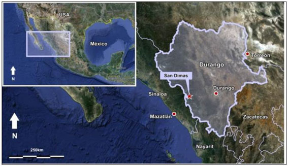
Note: Figure prepared by First Majestic, August 2025.
| 4.2. | Ownership |
In May 2018, First Majestic acquired San Dimas from Primero Mining Corp. Operations are conducted year-round by First Majestic’s indirectly wholly owned subsidiary, Primero Empresa.
| 4.3. | Mineral Tenure |
In Mexico, mineral rights can be held by private parties through mining concessions granted by the federal government via the Mines Directorate of the Ministry of Economy, and these are considered exploitation concessions with a 50-year term. The San Dimas property consists of 119 individual concessions covering 71,868 ha in total that have been organized into six concessions groups to facilitate land management. These concessions groups are San Dimas, Candelero, Ventanas, Lechuguillas, Cebollas and Truchas. A
| 26 | September 2025 |
| San Dimas Silver/Gold Mine Durango and Sinaloa States, Mexico NI-43-101 Technical Report on Mineral Resource and Mineral Reserve Estimates |
|
concession location map is shown in Figure 4-2 , and the individual concessions groups are shown in Figure 4-3 to Figure 4-8.
Figure 4-2: Map of the Concession Outlines for the San Dimas Property
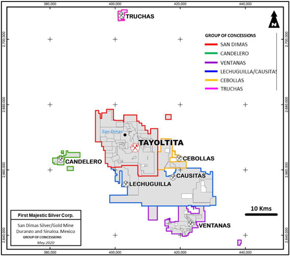
Note: Figure prepared by First Majestic, August 2025.
| 27 | September 2025 |
| San Dimas Silver/Gold Mine Durango and Sinaloa States, Mexico NI-43-101 Technical Report on Mineral Resource and Mineral Reserve Estimates |
|
Figure 4-3: Map of the San Dimas Concessions Group
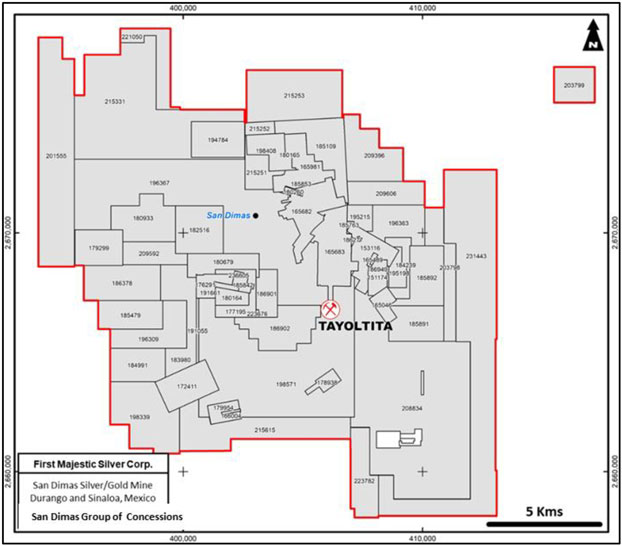
Note: Figure prepared by First Majestic, August 2025.
| 28 | September 2025 |
| San Dimas Silver/Gold Mine Durango and Sinaloa States, Mexico NI-43-101 Technical Report on Mineral Resource and Mineral Reserve Estimates |
|
Figure 4-4: Map of the Candelero Concessions Group
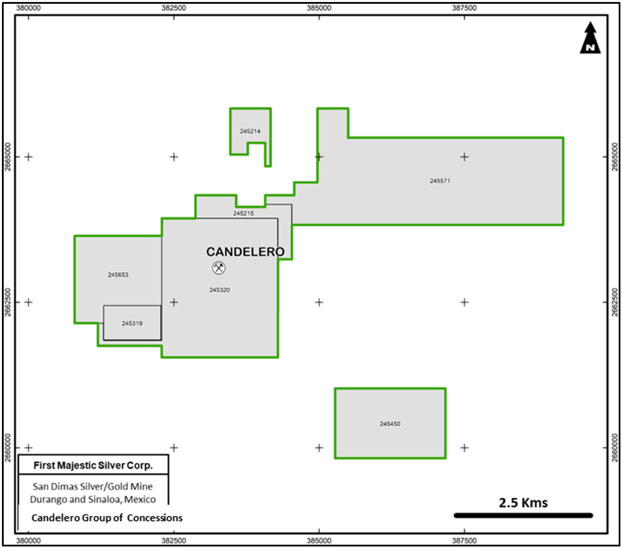
Note: Figure prepared by First Majestic, August 2025.
| 29 | September 2025 |
| San Dimas Silver/Gold Mine Durango and Sinaloa States, Mexico NI-43-101 Technical Report on Mineral Resource and Mineral Reserve Estimates |
|
Figure 4-5: Map of the Ventanas Concessions Group
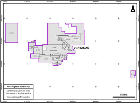
Note: Figure prepared by First Majestic, August 2025.
Figure 4-6: Map of the Lechuguillas Concessions Group
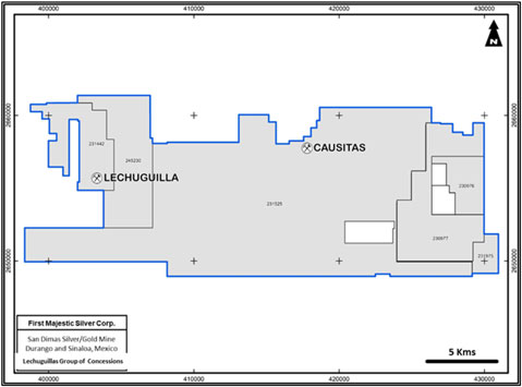
Note: Figure prepared by First Majestic, August 2025.
| 30 | September 2025 |
| San Dimas Silver/Gold Mine Durango and Sinaloa States, Mexico NI-43-101 Technical Report on Mineral Resource and Mineral Reserve Estimates |
|
Figure 4-7: Map of the Cebollas Concessions Group
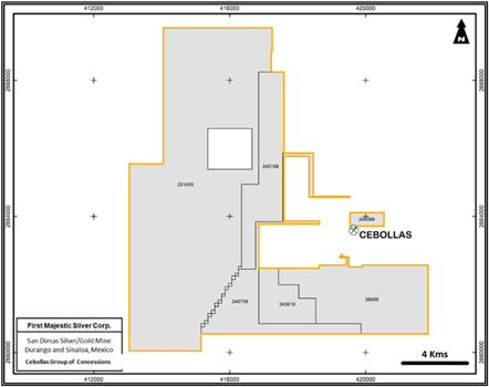
Note: Figure prepared by First Majestic, August 2025.
Figure 4-8: Map of the Truchas Concessions Group
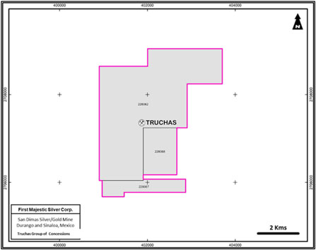
Note: Figure prepared by First Majestic, August 2025.
| 31 | September 2025 |
| San Dimas Silver/Gold Mine Durango and Sinaloa States, Mexico NI-43-101 Technical Report on Mineral Resource and Mineral Reserve Estimates |
|
Table 4-1 to Table 4-7 list the concessions by concession group. Concessions have expiry dates ranging from 2029 to 2070, of which 13 have renewal applications applied for, as shown in Table 4-1.
Table 4-1: Summary of the Six Concession Groups, San Dimas Property
| Concession Group |
# Concession | Status | Renewal | Size (Ha) | ||||||||||||
| San Dimas |
66 | 66 | 0 | 24,966 | ||||||||||||
| Candelero |
7 | 7 | 0 | 1,785 | ||||||||||||
| Ventanas |
30 | 29 | 1 | 7,702 | ||||||||||||
| Lechuguillas |
6 | 6 | 0 | 29,866 | ||||||||||||
| Cebollas |
7 | 6 | 1 | 6,907 | ||||||||||||
| Truchas |
3 | 3 | 0 | 641 | ||||||||||||
|
|
|
|
|
|
|
|
|
|||||||||
| Total |
119 | 117 | 2 | 71,868 | ||||||||||||
|
|
|
|
|
|
|
|
|
|||||||||
Table 4-2: San Dimas Concessions Group List
| Concession |
Title | Size (Ha) | Status | State | Area | Valid to | ||||||
| San Manuel |
151174 | 104 | Active | Durango | SAN DIMAS | 2069-03-23 | ||||||
| Chela |
153116 | 254 | Active | Durango | SAN DIMAS | 2070-07-13 | ||||||
| Resurgimiento |
165046 | 93 | Active | Durango | SAN DIMAS | 2029-08-22 | ||||||
| Yolanda |
165489 | 10 | Active | Durango | SAN DIMAS | 2029-10-10 | ||||||
| San Luis 1 |
165682 | 391 | Active | Durango | SAN DIMAS | 2029-11-27 | ||||||
| San Luis 2 |
165683 | 474 | Active | Durango | SAN DIMAS | 2029-11-27 | ||||||
| San Luis 3 |
165981 | 307 | Active | Durango | SAN DIMAS | 2030-02-03 | ||||||
| El Reliz |
166004 | 8 | Active | Durango | SAN DIMAS | 2030-02-19 | ||||||
| Carrizo |
166615 | 2 | Active | Durango | SAN DIMAS | 2030-06-26 | ||||||
| San Daniel |
172411 | 322 | Active | Sinaloa | SAN DIMAS | 2033-12-14 | ||||||
| Castellana Uno |
176291 | 108 | Active | Durango | SAN DIMAS | 2035-08-25 | ||||||
| Libia Estela |
177195 | 151 | Active | Durango | SAN DIMAS | 2036-03-03 | ||||||
| Promontorio |
177826 | 2 | Active | Durango | SAN DIMAS | 2036-04-28 | ||||||
| San Miguel |
178938 | 66 | Active | Durango | SAN DIMAS | 2036-10-27 | ||||||
| San Vicente Fracc. Suroeste |
179299 | 300 | Active | Sinaloa | SAN DIMAS | 2036-12-07 | ||||||
| Ampliación de El Reliz |
179954 | 96 | Active | Durango | SAN DIMAS | 2037-03-22 | ||||||
| La Castellana |
180164 | 90 | Active | Durango | SAN DIMAS | 2037-03-23 | ||||||
| Hueco 2 |
180165 | 0.09 | Active | Durango | SAN DIMAS | 2037-03-23 | ||||||
| Juan Manuel |
180260 | 16 | Active | Durango | SAN DIMAS | 2037-03-23 | ||||||
| Ampl. Noche Buena en Frapopan |
180679 | 234 | Active | Durango | SAN DIMAS | 2037-07-13 | ||||||
| San Vicente Fraccion Norte |
180933 | 430 | Active | Durango y Sinaloa | SAN DIMAS | 2037-08-13 | ||||||
| Noche Buena en Frapopan |
182516 | 400 | Active | Durango | SAN DIMAS | 2038-07-14 | ||||||
| Ampl. Nuevo Contra Estaca Fracción B |
183980 | 406 | Active | Durango y Sinaloa | SAN DIMAS | 2038-11-24 | ||||||
| Guarisamey III |
184239 | 115 | Active | Durango | SAN DIMAS | 2039-02-14 | ||||||
| Ampl. Nuevo Contra Estaca Fracción A |
184991 | 319 | Active | Durango y Sinaloa | SAN DIMAS | 2039-12-12 | ||||||
| El Favorable |
185109 | 452 | Active | Durango | SAN DIMAS | 2039-12-13 | ||||||
| Hueco 1 |
185138 | 0.4 | Active | Durango | SAN DIMAS | 2039-12-13 |
| 32 | September 2025 |
| San Dimas Silver/Gold Mine Durango and Sinaloa States, Mexico NI-43-101 Technical Report on Mineral Resource and Mineral Reserve Estimates |
|
| Concession |
Title | Size (Ha) | Status | State | Area | Valid to | ||||||
| Nuevo Contra Estaca Fracc. W |
185479 | 324 | Active | Durango y Sinaloa | SAN DIMAS | 2039-12-13 | ||||||
| Armida Sur |
185763 | 6 | Active | Durango | SAN DIMAS | 2039-12-13 | ||||||
| La Fe |
185842 | 39 | Active | Durango | SAN DIMAS | 2039-12-13 | ||||||
| Juan Manuel Dos |
185853 | 4 | Active | Durango | SAN DIMAS | 2039-12-13 | ||||||
| Guarisamey Fracción B |
185891 | 330 | Active | Durango | SAN DIMAS | 2039-12-13 | ||||||
| Guarisamey Fracción A |
185892 | 378 | Active | Durango | SAN DIMAS | 2039-12-13 | ||||||
| Armida Sur Fracc. II |
186277 | 3 | Active | Durango | SAN DIMAS | 2040-03-21 | ||||||
| Ampl. Nuevo Contra Estaca Fracción C |
186378 | 474 | Active | Durango y Sinaloa | SAN DIMAS | 2040-03-28 | ||||||
| San Miguel I |
186901 | 172 | Active | Durango | SAN DIMAS | 2040-05-16 | ||||||
| San Miguel 2 |
186902 | 452 | Active | Durango | SAN DIMAS | 2040-05-16 | ||||||
| Hueco Guarisamey |
186949 | 6 | Active | Durango | SAN DIMAS | 2040-05-16 | ||||||
| Armida Sur Fraccion. I |
189878 | 1 | Active | Durango | SAN DIMAS | 2040-12-05 | ||||||
| Hueco Tayoltita |
191055 | 28 | Active | Durango | SAN DIMAS | 2041-04-28 | ||||||
| La Soledad |
191661 | 21 | Active | Durango | SAN DIMAS | 2041-12-18 | ||||||
| Juan Manuel Tres |
194784 | 335 | Active | Durango | SAN DIMAS | 2042-06-14 | ||||||
| Guarisamey II |
195198 | 89 | Active | Durango | SAN DIMAS | 2042-08-24 | ||||||
| Armida |
195215 | 98 | Active | Durango | SAN DIMAS | 2042-08-24 | ||||||
| Nuevo Contra Estaca Fracc. E |
196309 | 376 | Active | Durango y Sinaloa | SAN DIMAS | 2043-07-15 | ||||||
| Guarisamey IV Fracción A |
196363 | 320 | Active | Durango | SAN DIMAS | 2043-07-15 | ||||||
| Tayoltita Norte |
196367 | 2,650 | Active | Durango y Sinaloa | SAN DIMAS | 2043-07-15 | ||||||
| Ampl SW Contra Estaca |
198339 | 663 | Active | Durango y Sinaloa | SAN DIMAS | 2043-11-18 | ||||||
| Alicia II |
198408 | 204 | Active | Durango | SAN DIMAS | 2043-11-25 | ||||||
| Tayoltita |
198571 | 2,320 | Active | Durango | SAN DIMAS | 2043-11-29 | ||||||
| Tayoltita Oeste |
201555 | 1,395 | Active | Durango y Sinaloa | SAN DIMAS | 2045-10-19 | ||||||
| Guarisamey V Fraccion 1 |
203798 | 333 | Active | Durango | SAN DIMAS | 2046-09-29 | ||||||
| Guarisamey Sur |
208834 | 3,026 | Active | Durango | SAN DIMAS | 2048-12-14 | ||||||
| Guarisamey Norte |
209396 | 489 | Active | Durango | SAN DIMAS | 2049-04-08 | ||||||
| Contra Estaca Norte |
209592 | 237 | Active | Durango y Sinaloa | SAN DIMAS | 2049-08-02 | ||||||
| Guarisamey IV Fracción B |
209606 | 321 | Active | Durango | SAN DIMAS | 2049-08-02 | ||||||
| SanLuis Norte 1 |
215251 | 175 | Active | Durango | SAN DIMAS | 2052-02-13 | ||||||
| SanLuis Norte 2 |
215252 | 66 | Active | Durango | SAN DIMAS | 2052-02-13 | ||||||
| SanLuis Norte 3 |
215253 | 839 | Active | Durango | SAN DIMAS | 2052-02-13 | ||||||
| Tayoltita Sur |
215615 | 784 | Active | Durango | SAN DIMAS | 2046-12-11 | ||||||
| San Miguel 3 |
223676 | 3 | Active | Durango | SAN DIMAS | 2055-02-01 | ||||||
| Guarisamey Suroeste |
223782 | 359 | Active | Durango | SAN DIMAS | 2055-02-14 | ||||||
| Frac. Ampl. Noche Buena en Frapopan |
236605 | 11 | Active | Durango | SAN DIMAS | 2060-07-27 | ||||||
| Guarisamey V Fracc. NE |
203799 | 253 | Active | Durango | SAN DIMAS | 2046-09-29 | ||||||
| Ampl. Tayoltita Norte |
215331 | 1,950 | Active | Durango | SAN DIMAS | 2044-04-18 | ||||||
| Tahonitas |
221050 | 283 | Active | Durango | SAN DIMAS | 2053-11-13 |
| 33 | September 2025 |
| San Dimas Silver/Gold Mine Durango and Sinaloa States, Mexico NI-43-101 Technical Report on Mineral Resource and Mineral Reserve Estimates |
|
Table 4-3: Candelero Concessions Group List
| Concession |
Title | Size (Ha) | Status | State | Area | Valid to | ||||||
| Candelero Uno Fracc. Uno |
245214 | 51 | Active | Sinaloa | CANDELERO | 2066-11-14 | ||||||
| Candelero Dos |
245571 | 699 | Active | Sinaloa | CANDELERO | 2067-08-30 | ||||||
| Candelero Uno Fracc. Dos |
245215 | 65 | Active | Sinaloa | CANDELERO | 2066-11-14 | ||||||
| Santa Cruz Tres |
245320 | 489 | Active | Sinaloa | CANDELERO | 2066-11-22 | ||||||
| Candelero II |
245653 | 195 | Active | Sinaloa | CANDELERO | 2067-10-14 | ||||||
| Santa Cruz |
245319 | 58 | Active | Sinaloa | CANDELERO | 2066-11-22 | ||||||
| Candelero Dos Fracc. 1 |
245450 | 228 | Active | Sinaloa | CANDELERO | 2067-02-27 |
Table 4-4: Ventanas Concession Group List
| Concession |
Title | Size (Ha) | Status | State | Area | Valid to | ||||||
| La Prieta |
151613 | 9 | Active | Durango | VENTANAS | 2069-07-10 | ||||||
| María Elena |
167072 | 22 | Active | Durango | VENTANAS | 2030-08-28 | ||||||
| El Rosario |
167073 | 15 | Active | Durango | VENTANAS | 2030-08-28 | ||||||
| Mina Grande |
167074 | 9 | Active | Durango | VENTANAS | 2030-08-28 | ||||||
| Buen Dia |
167075 | 57 | Active | Durango | VENTANAS | 2030-08-28 | ||||||
| Noche Buena |
167076 | 55 | Active | Durango | VENTANAS | 2030-08-28 | ||||||
| Josefina |
167077 | 3 | Active | Durango | VENTANAS | 2030-08-28 | ||||||
| San Cayetano |
167078 | 22 | Active | Durango | VENTANAS | 2030-08-28 | ||||||
| California |
167079 | 6 | Active | Durango | VENTANAS | 2030-08-28 | ||||||
| San Miguel |
167080 | 64 | Active | Durango | VENTANAS | 2030-08-28 | ||||||
| Concepción |
169369 | 6 | Active | Durango | VENTANAS | 2031-11-11 | ||||||
| Mala Noche |
184834 | 499 | Active | Durango | VENTANAS | 2039-12-04 | ||||||
| Los Chabelos |
186020 | 197 | Active | Durango | VENTANAS | 2039-12-13 | ||||||
| Los Muros |
203662 | 30 | Active | Durango | VENTANAS | 2046-09-12 | ||||||
| Ampl. La Prieta |
203983 | 110 | Active | Durango | VENTANAS | 2046-11-25 | ||||||
| Cuquita |
204383 | 41 | Active | Durango | VENTANAS | 2047-02-12 | ||||||
| Tayoltita I Fracc. A |
210494 | 226 | Active | Durango | VENTANAS | 2049-10-07 | ||||||
| Tayoltita I Fracc. B |
210773 | 440 | Active | Durango | VENTANAS | 2049-11-25 | ||||||
| Mala Noche Fracc. Sur |
214781 | 191 | Active | Durango | VENTANAS | 2039-12-04 | ||||||
| El Colorín Fracción Sur |
214785 | 151 | Active | Durango | VENTANAS | 2038-11-22 | ||||||
| Ampliación El Rosario |
214786 | 88 | Active | Durango | VENTANAS | 2039-10-30 | ||||||
| Nuevo Ventanas Fracc. E |
214787 | 55 | Active | Durango | VENTANAS | 2040-12-04 | ||||||
| San Cayetano |
214788 | 351 | Active | Durango | VENTANAS | 2041-12-18 | ||||||
| Nuevo Ventanas Fracc. W |
214789 | 195 | Active | Durango | VENTANAS | 2039-10-09 | ||||||
| Mala Noche Oeste |
214842 | 280 | Active | Durango | VENTANAS | 2043-07-15 | ||||||
| Ampliación Mina Grande |
215332 | 117 | Active | Durango | VENTANAS | 2047-01-30 | ||||||
| Mala Noche Norte Fracc. 1 |
215614 | 126 | Active | Durango | VENTANAS | 2044-04-18 | ||||||
| Mala Noche Norte Fracc. 2 |
215731 | 104 | Active | Durango | VENTANAS | 2044-04-18 | ||||||
| Nuevo Mala Noche |
243489 | 775 | Active | Durango | VENTANAS | 2064-10-09 | ||||||
| Ampl. Mala Noche Frac. 2 |
38839 | 1,180 | In Process | Durango | VENTANAS | In Process | ||||||
| Ampl. Mala Noche Frac. 1 |
38839 | 2,250 | In Process | Durango | VENTANAS | In Process |
| 34 | September 2025 |
| San Dimas Silver/Gold Mine Durango and Sinaloa States, Mexico NI-43-101 Technical Report on Mineral Resource and Mineral Reserve Estimates |
|
Table 4-5: Lechuguillas Concessions Group List
| Concession |
Title | Size (Ha) | Status | State | Area | Valid to | ||||||
| El Gavilán 2 |
230976 | 990 | Active | Durango | LECHUGUILLA | 2057-11-21 | ||||||
| El Gavilán 3 |
230977 | 3,191 | Active | Durango | LECHUGUILLA | 2057-11-21 | ||||||
| El Alacrán |
231975 | 455 | Durango | LECHUGUILLA | 2058-05-27 | |||||||
| San José de Causas |
231525 | 20,341 | Active | Sinaloa y Durango | LECHUGULLA | 2058-03-06 | ||||||
| El Cuervo |
231442 | 2,042 | Active | Sinaloa y Durango | LECHUGUILLA | 2058-02-27 | ||||||
| Tayoltita Sur Uno |
245230 | 2,847 | Active | Sinaloa y Durango | LECHUGUILLA | 2066-11-14 |
Table 4-6: Cebollas Concessions Group List
| Concession |
Title | Size (Ha) | Status | State | Area | Valid to | ||||||
| Temehuaya 2 |
231439 | 2679 | Active | Durango | CEBOLLAS | 2058-02-27 | ||||||
| El Tecolote |
231443 | 2,490 | Active | Durango | CEBOLLAS | 2046-09-27 | ||||||
| Anexo Cebollas |
245158 | 433 | Active | Durango | CEBOLLAS | 2066-11-07 | ||||||
| Nuevo Cebollas Siete |
246738 | 368 | Active | Durango | CEBOLLAS | 2068-11-08 | ||||||
| Nuevo Cebollas Seis |
245619 | 200 | Active | Durango | CEBOLLAS | 2067-09-07 | ||||||
| Nuevo Cebollas Tres |
245568 | 40 | Active | Durango | CEBOLLAS | 2067-08-17 | ||||||
| Nuevo Cebollas Cuatro |
38889 | 699 | In Process | Durango | CEBOLLAS | In Process |
Table 4-7: Truchas Concessions Group List
| Concessions |
Title | Size (Ha) | Status | State | Area | Valid to | ||||||
| Ejido Huahuapan |
228062 | 500 | Active | Durango | TRUCHAS | 2056-09-28 | ||||||
| Truchas Uno |
228067 | 59 | Active | Durango | TRUCHAS | 2056-09-28 | ||||||
| Truchas Dos |
228068 | 82 | Active | Durango | TRUCHAS | 2056-09-28 |
As per Mexican requirements for grant of tenure, the concessions comprising the San Dimas property have been surveyed on the ground by a licensed surveyor.
All applicable payments and reports have been submitted to the relevant authorities, and the licenses are in good standing as at the Technical Report effective date.
| 4.4. | Royalties |
Discussion on the streaming agreement with Wheaton Precious Metals International Ltd. (Wheaton Precious Metals) is provided in Section 19 of this Technical Report.
| 4.5. | Surface Rights |
Surface rights in Mexico are separate from mineral rights. Under the mining law, mining rights holders have the right to use and access areas that are planned for exploration or exploitation. First Majestic (and its predecessor companies) secured surface rights by either acquisition of private and public land or by entering into temporary occupation agreements with surrounding communities.
| 35 | September 2025 |
| San Dimas Silver/Gold Mine Durango and Sinaloa States, Mexico NI-43-101 Technical Report on Mineral Resource and Mineral Reserve Estimates |
|
The local communities are Ejidos, village lands communally held in the traditional system of surface land tenure that combine communal ownership with individual use. The most relevant Ejido in the area is the Ejido San Dimas as more the majority of the production comes from mineralization located under this Ejido. Agreements with Ejido San Dimas are in place for the use of surface land for exploration activities and ventilation infrastructure. The second most relevant Ejido in terms of surface rights is the Rincon de Calabazas Ejido, which covers prospective ground within the San Dimas property. An agreement dated October 2019 with the Rincon de Calabazas Ejido allows First Majestic to occupy surface land for exploration activities and ventilation infrastructure for a period of seven and a half years. It is expected that the agreement will be able to be renewed at the end of the current agreement period.
| 4.6. | Permitting Considerations |
San Dimas holds major environmental permits and licenses required by the Mexican authorities to carry out mineral extracting activities in the mining complex. As a historic operation the mine pre-dates several of the Mexico mining regulations, the Company has endeavoured to progressively acquire permits and regularize the operation as well as addressing historic environmental liabilities. Details of the permits held in support of operations are discussed in Section 20 of this Technical Report.
| 4.7. | Environmental Considerations |
Environmental considerations are discussed in Section 20 of this Technical Report.
| 4.8. | Existing Environmental Liabilities |
Environmental liabilities for the operation are typical of those that would be expected to be associated with an operating underground precious metals mine, including the future closure and reclamation of mine portals and ventilation infrastructure, access roads, processing facilities, hydroelectric plant, power lines, dry-stacked tailings and all surface infrastructure that supports the operations.
Primero Empresa is currently mitigating two past environmental liabilities: reclamation of the old San Antonio milling facilities (Contraestaca) and closure/reclamation of the old San Antonio tailings facilities. The dismantling of the mills, structures, and tanks was completed several years ago. The remaining work to reclaim the old San Antonio mill site and the tailings facility is ongoing with funds allocated in the asset retirement obligation (ARO).
Additional information on the environmental considerations for San Dimas district is provided in Section 20.
| 4.9. | Significant Factors and Risks |
To the extent known to the QPs, there are no other significant factors and risks that may affect access, title, or the legal right or ability to perform work at San Dimas that are not discussed in this Technical Report.
| 36 | September 2025 |
| San Dimas Silver/Gold Mine Durango and Sinaloa States, Mexico NI-43-101 Technical Report on Mineral Resource and Mineral Reserve Estimates |
|
| 5. | ACCESSIBILITY, CLIMATE, LOCAL RESOURCES, INFRASTRUCTURE, AND PHYSIOGRAPHY |
| 5.1. | Accessibility |
The San Dimas processing facilities are located near the town of Tayoltita, which has a population of approximately 10,000 inhabitants.
Access to San Dimas is by air or road from the cities of Durango and Mazatlán. The town of Tayoltita has an airstrip and a licensed airport, First Majestic owns and operates a fully licensed airline company, Primero Transportes Aereos, S.A. de C.V., which owns and maintains a Havilland Twin Otter aircraft and a helicopter, both of which are based at Tayoltita. Other commercial air-transportation companies schedule regular daily flights to Tayoltita. Flights from either Mazatlán or Durango to the town of Tayoltita require approximately 40 minutes. Most of the transportation of personnel and light supplies, as well as emergency transportation, is attended to by First Majestic’s regular flights from Mazatlán and Durango to and from the site. Heavy equipment and supplies are brought in by road mainly from Durango.
A new road connecting Mazatlán with Tayoltita has been completed, it is a year-round route via a ~240km long paved road, the trip from Mazatlán to Tayoltita requires about four hours.
The access from Durango City is an all-year route via a 112 km-long paved road from Durango to the town of Santa Lucia and a 120 km service road from Santa Lucia to Tayoltita. This trip takes about six and a half hours.
Figure 5-1 shows the access by road to San Dimas and the property location with respect to Mazatlán and Durango.
| 37 | September 2025 |
| San Dimas Silver/Gold Mine Durango and Sinaloa States, Mexico NI-43-101 Technical Report on Mineral Resource and Mineral Reserve Estimates |
|
Figure 5-1: Road Access to the San Dimas Property, near Tayoltita
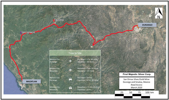
Note: Figure prepared by First Majestic, August 2025.
| 5.2. | Climate |
The climate of the San Dimas district is semi-tropical, characterized by relatively hot temperatures and humidity, with hot summers (maximum around 39°C) and mild winters (minimum 11°C). At higher elevations in the Sierra, frosty nights occur in the winter (November through March). The majority of the precipitation occurs in the summer (June through September); however, tropical rainstorms between October and January can result in considerable additional rainfall. The average annual rainfall fluctuates between 66 and 108 mm. Exceptionally, in 2019 the annual rainfall was 488 mm.
The Las Truchas hydroelectric plant provides energy to the San Dimas operation. The water is collected from streams into a water dam located on the plateau. The power generated by the Las Truchas hydroelectric plant is relevant for the operation in terms of cost effectiveness and reliability as power from the grid provided by the Federal Commission of Electricity (CFE) is more expensive and has frequent, short, outages that can disrupt the operations.
As prolonged drought conditions could affect operations, First Majestic is assessing the economic merit of expanding the hydro dam capacity (discussed in Section 26) and has incorporated Liquefied Natural Gas energy generation.
Weather does not affect the mining and processing operations, and these activities are carried out on a year-round basis.
| 38 | September 2025 |
| San Dimas Silver/Gold Mine Durango and Sinaloa States, Mexico NI-43-101 Technical Report on Mineral Resource and Mineral Reserve Estimates |
|
| 5.3. | Local Resources and Infrastructure |
Tayoltita is the largest population centre in the region. Including mining personnel, the town has approximately 10,000 inhabitants. Population outside of this center is sparse. Subsistence farming, ranching, logging, and mining are the predominant activities in the region.
Mining activities at San Dimas are performed by a combination of First Majestic personnel and contract workers.
Surface rights for mining operations are up to date.
Water for the mining operations is obtained from wells, underground dewatering, recycled from processing activities and from the Piaxtla River.
Power is provided by a combination of hydroelectric, gas generation, and the federal grid system.
Tailings and waste storage areas, as well as the processing facility are well established.
Figure 5-2 shows an aerial view of the mill in the foreground, the airstrip to the right, and the rugged terrain within which San Dimas is situated.
Details of the infrastructure that supports San Dimas are provided in Section 18 of this Technical Report.
Collectively, these conditions are sufficient for ongoing mining operations at San Dimas.
| 39 | September 2025 |
| San Dimas Silver/Gold Mine Durango and Sinaloa States, Mexico NI-43-101 Technical Report on Mineral Resource and Mineral Reserve Estimates |
|
Figure 5-2: Processing Plant, Airstrip and Rugged Terrain, Aerial View looking East
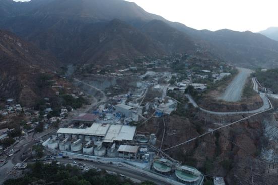
Note: Image taken by First Majestic, August 2025.
| 5.4. | Physiography |
San Dimas is located in the central part of the Sierra Madre Occidental, a mountain range characterized by rugged topography with steep, often vertical, walled valleys, and narrow canyons. Elevations vary from 2,400 metres above mean sea level (masl) on the high peaks to elevations of 400 masl in the valley floor of the Piaxtla River.
The main drainage in the San Dimas district is the Piaxtla River and its tributaries. The Piaxtla River is a short coastal river whose source is in the Sierra Madre, close to the Durango–Sinaloa state border, and which flows into the Pacific Ocean. The Piaxtla River has a length of 220 km and drains a basin of 11,473 km².
Vegetation at the mid-to-higher elevations is dominated by pines, junipers, and to a lesser extent, oaks, while the lower slopes and valleys are covered with thick brush, cacti, and grass.
| 5.5. | Comment on Section 5 |
In the opinion of the QPs, the existing local infrastructure, availability of staff, and methods whereby goods are transported to San Dimas are well-established and well understood by First Majestic and can support the declaration of Mineral Resources and Mineral Reserves (see discussion in Section 18).
| 40 | September 2025 |
| San Dimas Silver/Gold Mine Durango and Sinaloa States, Mexico NI-43-101 Technical Report on Mineral Resource and Mineral Reserve Estimates |
|
All necessary primary infrastructure for the current operations is operational, being maintained and is sufficient for the projected LOM plan (see discussion in Section 18).
Surface rights for infrastructure and mining are discussed in Section 4.5.
Operations are currently conducted year-round.
| 41 | September 2025 |
| San Dimas Silver/Gold Mine Durango and Sinaloa States, Mexico NI-43-101 Technical Report on Mineral Resource and Mineral Reserve Estimates |
|
| 6. | HISTORY |
| 6.1. | Ownership History |
The San Dimas property contains a series of epithermal gold silver veins that have been mined intermittently since 1757. Modern mining began in the 1880s, by the American-owned San Luis Mining Company and the Mexican-owned Candelaria Company.
In 1961, Minas de San Luis, a company owned by Mexican interests, acquired 51% of San Dimas group of properties and assumed operations of the mine. In 1978, the remaining 49% interest in the mine was obtained by Luismin S.A. de C.V (Luismin). In 2002, Wheaton River Minerals Ltd. (Wheaton River) acquired the property from Luismin and in 2005 Wheaton River merged with Goldcorp Inc. (Goldcorp). Under its prior name Mala Noche Inc., Primero Mining Corp. (Primero) acquired San Dimas from subsidiaries of Goldcorp in August 2010. In May 2018, First Majestic acquired 100% interest in San Dimas property through acquisition of Primero.
| 42 | September 2025 |
| San Dimas Silver/Gold Mine Durango and Sinaloa States, Mexico NI-43-101 Technical Report on Mineral Resource and Mineral Reserve Estimates |
|
Table 6-1 summarizes the San Dimas property ownership history.
| 43 | September 2025 |
| San Dimas Silver/Gold Mine Durango and Sinaloa States, Mexico NI-43-101 Technical Report on Mineral Resource and Mineral Reserve Estimates |
|
Table 6-1: Summary History of San Dimas Property
| Time Period | Milestone | |
| 1757–1810 |
There is record of Hispanic mining production in the area during the 16th and 17th centuries Spaniards exploited the high-grade areas of the Los Queleles and other gold and silver mines |
|
| 1810–1821 |
Mexican War of Independence. Mining activities ceased in the region. |
|
| 1821–1880 |
The region remained isolated with minor mining activities. |
|
| 1880–1882 |
Mining activities were reactivated by William Randolph Hearst, who purchased the old Tayoltita mine under the name of the San Luis Mining Company. |
|
| 1883 |
Colonel Burns took control of the Candelaria mine. |
|
| 1883–1904 |
The Contraestaca (San Antonio) mine was discovered, together with several large, high-grade deposits. |
|
| 1904 |
A mill and a flotation plant/cyanide circuit were built for the first time in Mexico. |
|
| 1940 |
Candelaria mined out. The mineral rights were purchased by the San Luis Mining Company. |
|
| 1941 |
The San Dimas group of properties was consolidated under the ownership of the San Luis Mining Company. |
|
| 1959 |
Mexican law governing natural resources requires that 51% of the ownership of a mining company must be held by Mexican nationals. |
|
| 1961 |
Minas de San Luis S.A. de C.V., a company owned by Mexican interests, acquires 51% of the San Dimas group of properties. |
|
| 1962–1977 |
The mine is operated by a partnership between the San Luis Mining Company and Minas de San Luis S.A. de C.V. |
|
| 1978 |
A subsidiary of Minas de San Luis S.A. de C.V., Luismin, acquires the remaining 49% of the San Luis Mining Company. |
|
| 1982 |
Luismin acquired the Ventanas Concessions Group |
|
| 1978–2001 |
Luismin, as sole operator, operates continuously with an average production rate of 700 tpd. |
|
| 2002 |
Luismin sells the San Dimas operations to Wheaton River Minerals Ltd. (Wheaton River). |
|
| 2003 |
Production rate is increased to 1,600 tpd. |
|
| 2005 |
Wheaton River merges with Goldcorp. Inc. |
|
| 2006 |
Production rate is increased to 2,100 tpd. |
|
| 2010 |
Mala Noche Inc. acquires a 100% interest in the San Dimas mine, enters into a streaming contract with Wheaton Precious Metals, successor to Wheaton River. |
|
| 2011 |
Mala Noche Inc. changes its name to Primero Mining Corp. (Primero). |
|
| 2011–2018 |
Primero is mine operator, with a production peak of 2,800 tpd in 2016. Primero increased the land position by acquiring an interest in the Lechuguillas Concessions Group. |
|
| 2018 |
In May 2018, First Majestic acquires a 100% interest in the San Dimas Project through acquisition of Primero. The streaming contract with Wheaton Precious Metals is renegotiated. |
|
| 6.2. | Exploration History |
In the San Dimas district, there are historical records that mention workings as far back as 1757, but it would not be until 1890 that there would be formal operations by the American-owned San Luis Mining Company and the Mexican-owned Candelaria Company. Later, in the 1960s, higher-grade discoveries would lead to the first deep drilling campaigns and to excavation of the initial long mining tunnels.
In 1975, the first 4.5km-long tunnel, the longest in the district at the time, was completed at the Tayoltita mine, this being an area where mineralization discoveries such as the San Luis vein had taken place following the Favorable Zone concept aided by field geology (see Section 7.4). In the 1980s, American and
| 44 | September 2025 |
| San Dimas Silver/Gold Mine Durango and Sinaloa States, Mexico NI-43-101 Technical Report on Mineral Resource and Mineral Reserve Estimates |
|
Mexican groups commenced operations that led to the first geophysical and geochemical exploration in the southeast of the area known as the Tayoltita Block. As a result of the exploration the Santa Rita vein was discovered in what became known as the Santa Rita Area.
By the late 1980s and early 1990s, the Favorable Zone concept and Ag:Au ratios supported by fluid inclusion and thermal fusion studies led to discovery of the San Antonio area on the western side of the Tayoltita mine. After acquisition of the property by Luismin, there was a significant reduction in exploration activities throughout the whole mining district.
Wheaton River completed long drill holes together with excavation of long tunnels that were perpendicular to the general trend of veins. Examples of these tunnels include San Luis, Santa Anita, and Sinaloa Graben (Figure 6-1), where significant intersections and new high-grade veins were discovered. Exploration of these veins by drilling and the development of tunneling continued during the Primero ownership period. The Sinaloa Graben and San Fernando tunnels were extended to the north, intercepting more veins, which are currently in production.
Exploration and drilling activities conducted by First Majestic are summarized in Section 9 and Section 10 of this Technical Report.
| 45 | September 2025 |
| San Dimas Silver/Gold Mine Durango and Sinaloa States, Mexico NI-43-101 Technical Report on Mineral Resource and Mineral Reserve Estimates |
|
Figure 6-1: Map showing Mining Tunnels at the Time Wheaton River Acquired the Property
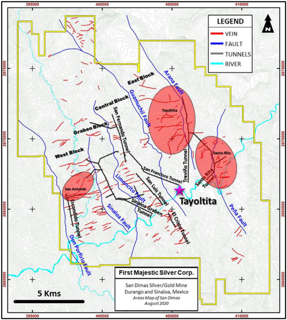
Note: Figure modified by First Majestic after Goldcorp., 2010.
| 46 | September 2025 |
| San Dimas Silver/Gold Mine Durango and Sinaloa States, Mexico NI-43-101 Technical Report on Mineral Resource and Mineral Reserve Estimates |
|
| 6.3. | Production History |
Historical production to date from the San Dimas district is estimated at more than 710 Moz of silver and more than 10 Moz of gold (Enriquez et al., 2018), placing the district third in Mexico for precious metal production after Pachuca and Guanajuato. Production from 2014 to 2024 San Dimas is shown in Figure 6-2, San Dimas historical production to December 2024 is estimated at more than 766 Moz of silver and more than 11.1 Moz of gold.
Figure 6-2: San Dimas Production from 2014 to 2024
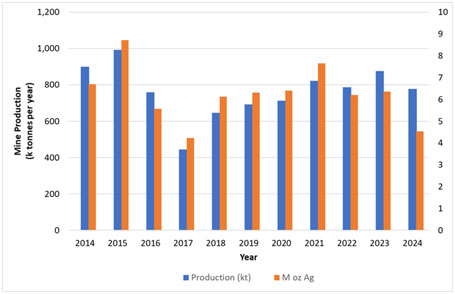
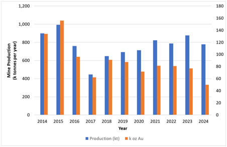
Note: Figure prepared by First Majestic, April 2025.
| 47 | September 2025 |
| San Dimas Silver/Gold Mine Durango and Sinaloa States, Mexico NI-43-101 Technical Report on Mineral Resource and Mineral Reserve Estimates |
|
| 7. | GEOLOGICAL SETTING AND MINERALIZATION |
| 7.1. | Regional Geology |
Information on the regional setting for the San Dimas district has been summarized primarily from Montoya et al. (2019, 2020) and Enriquez et al. (2001).
The San Dimas district is located in the central part of the Sierra Madre Occidental (SMO), near the Sinaloa-Durango state border. As a physiographic province, the SMO comprises a high plateau with an average elevation exceeding 2000m above sea level, extending from the Mexico-US border to the Trans-Mexican Volcanic Belt. Numerous epithermal deposits have been found along the SMO (Figure 7-1).
Figure 7-1: Physiographic Provinces around the San Dimas District
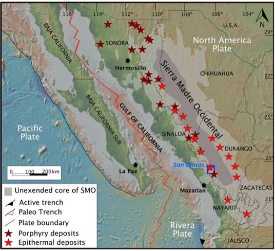
Note: Figure from Montoya et. al., 2019.
The SMO includes primarily Late Cretaceous to early Miocene igneous rocks formed during two main periods of continental magmatic activity (Ferrari et al., 2018a) (Figure 7-2).
| 48 | September 2025 |
| San Dimas Silver/Gold Mine Durango and Sinaloa States, Mexico NI-43-101 Technical Report on Mineral Resource and Mineral Reserve Estimates |
|
Figure 7-2: Regional Geological Map of Central Sierra Madre Occidental
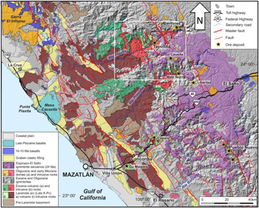
Note: from Montoya et al., 2019. Showing the Main Post-Eocene Extensional Structures and Principal Mining Districts. San Dimas enclosed within the white frame.
Two major volcanic successions from these periods represent approximately 3,500 m in thickness and are separated by erosional and depositional unconformities. They are known as Lower Volcanic Complex (LVC) and Upper Volcanic Group (UVG)
The LVC consists of predominantly intermediate volcanic and intrusive rocks, the so-called Laramide magmatic arc, which developed during east-verging subduction of the Farallon plate beneath the North America continent between approximately 100 and 50 Ma (Gastil, 1975; Henry et al., 2003; McDowell et al., 2001; Ortega-Gutiérrez et al., 2014; Valencia-Moreno et al., 2017). After a transitional period that lasted until the late Eocene (Ferrari et al., 2018a), volcanism became markedly silicic and then bimodal, forming the UVG. Silicic ignimbrites represent the overwhelming component of this volcanism, which makes the Sierra Madre Occidental one of the largest silicic volcanic provinces on Earth (Bryan and Ferrari, 2013). Most of these rocks were deposited during two ignimbrite episodes at approximately 35–29 Ma along the entire province and at approximately 24–20 Ma in the southern SMO (Ferrari et al.,2002, 2007; McDowell and McIntosh, 2012). Mafic lavas, often with an intraplate affinity, are found intercalated within the ignimbrite successions since 33 Ma (Ferrari et al., 2018a; 2018b).
| 49 | September 2025 |
| San Dimas Silver/Gold Mine Durango and Sinaloa States, Mexico NI-43-101 Technical Report on Mineral Resource and Mineral Reserve Estimates |
|
This section is primarily summarized from Montoya et al., 2019, and Enriquez and Rivera, 2001.
In the San Dimas district, the local geology is defined by the LVC and the UVG. These volcanic successions are separated by erosional and depositional unconformities and are intruded by intermediate and basic rocks.
| 7.1.1. | Stratigraphy |
A general stratigraphic column for the San Dimas district is provided in Figure 7-3 and a general geology map of the area is included as Figure 7-4.
Figure 7-3: Stratigraphic Column, San Dimas District
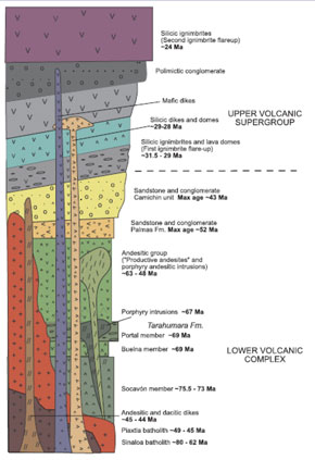
Note: Figure from Montoya et al., 2019.
| 50 | September 2025 |
| San Dimas Silver/Gold Mine Durango and Sinaloa States, Mexico NI-43-101 Technical Report on Mineral Resource and Mineral Reserve Estimates |
|
Figure 7-4: Geological Map of San Dimas Property
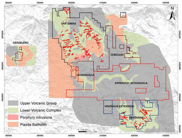
Note: Lines in red represent veins. Figure prepared by First Majestic April 2025.
| 7.1.2. | Lower Volcanic Complex (LVC) |
The LVC has traditionally been divided into informal geological units, primarily based on field observations. From base to top, these are the Socavón rhyolite, the Buelna andesite, and the Portal rhyolite, defined as a sequence of interlayered tuffs and lesser lava flows of felsic to intermediate composition (Locke, 1918; Davidson, 1932; Henshaw, 1953):
| • | The Socavón rhyolite is more than 700 m thick and is host to several productive veins in the district; |
| • | The Buelna andesite, which is remarkably persistent throughout the area, is well-bedded, and ranges in thickness from 20–75 m; |
| • | The Portal rhyolite is a grey, cream- to purple-coloured rock containing potassic feldspar and quartz that cement small (5–10 mm) volcanic rock fragments. It ranges in thickness from 50–250 m and is also prevalent throughout the district. |
These rocks are unconformably overlain by a succession of informally named andesitic lavas and sedimentary rocks, from base to top, including:
| 51 | September 2025 |
| San Dimas Silver/Gold Mine Durango and Sinaloa States, Mexico NI-43-101 Technical Report on Mineral Resource and Mineral Reserve Estimates |
|
| • | The Productive andesite, >750 m thick, divided into two varieties based on grain size, but which are of identical mineralogy. One variety is fragmental (varying from a lapilli tuff to coarse agglomerate), and the other has a porphyritic texture (1–2 mm plagioclase phenocrysts); |
| • | The Las Palmas formation, composed of purple to red interbedded rhyolitic and andesite tuffs and flows, and >300 m thick; |
| • | The Camichin unit, comprises green epiclastic conglomerates at the base and red arkoses and shales at the top, with a total thickness of approximately 300 m. This unit crops out extensively in the Tayoltita area. |
| 7.1.3. | Upper Volcanic Group (UVG) |
In the San Dimas district, the UVG is informally divided into a subordinate lower unit composed mainly of lavas of intermediate composition, the Guarisamey andesite, and an upper unit, the Capping rhyolite. The Capping rhyolite consists of rhyolitic ash flows and air-fall tuffs, may reach as much as 1,500 m in thickness in the eastern part of the district; however, within most of the district it is averages about 1,000 m thick.
| 7.1.4. | Intrusive Rocks |
The two volcano–volcaniclastic successions are intruded by intermediate rocks, consisting of the Arana intrusive andesite and the Arana intrusive diorite (Henshaw, 1953), and a felsic suite comprising the Piaxtla granite and Santa Lucia, Bolaños, and Santa Rita dikes. The basic dikes intrude both the LVC and the UVG.
| 7.1.5. | Structural Geology |
The structural context for the San Dimas property was investigated by Ballard (1980), who focused on the structural control of mineralization in the Tayoltita mine, and by Horner and Enriquez (1999), who studied the structural geology and tectonic controls for the district as a whole.
Figure 7-5 shows the structural geology and major faults relative to the underground mines. The most prominent structures are major north–northwest-trending normal faults with opposite vergence that divide the district into five fault-bounded blocks that are tilted to the east–northeast or west–northwest (Enriquez and Rivera, 2001).
| 52 | September 2025 |
| San Dimas Silver/Gold Mine Durango and Sinaloa States, Mexico NI-43-101 Technical Report on Mineral Resource and Mineral Reserve Estimates |
|
Figure 7-5: San Dimas Structural Map
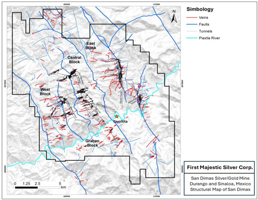
Note: Figure prepared by First Majestic, April 2025.
All the major faults exhibit northeast–southwest extension. Dips vary from nearly vertical to approximately 55° (Horner and Enriquez, 1999). East–west to west–southwest–east–northeast striking fractures, perpendicular to the major normal faults, are often filled by quartz veins, dacite porphyry dikes, and pebble dikes. These are later cut by rhyolite porphyry dikes that intruded north–south to north–northwest–south–southeast trending fissures (Smith et al., 1982). Horner and Enriquez (1999) grouped the development of major faults, veins, and dikes into three deformational events:
| • | D1: Represented by tension gashes with an east–west to northeast–southwest orientation and a slight right-lateral offset. Developed in the late Eocene. These structures host the first hydrothermal vein systems; |
| • | D2: Produced north–south-trending right-lateral strike-slip to transtensional faults due to a rotation of the maximum horizontal principal stress to an approximate northeast–southwest position. In this stage, interpreted to have occurred in the early Oligocene, a second set of hydrothermal veins developed; |
| • | D3: Produced the major block faulting that affected the entire district along northwest–southeast-striking normal faults, which in some cases reactivated the former strike-slip faults during the late Oligocene–Miocene period. These faults host bimodal dikes, which are part of the UVG. The |
| 53 | September 2025 |
| San Dimas Silver/Gold Mine Durango and Sinaloa States, Mexico NI-43-101 Technical Report on Mineral Resource and Mineral Reserve Estimates |
|
northwest–southeast (D3 event) extensional fault systems exposed the mineralization and tilted all the succession prior to the deposition of a ~24 Ma ignimbrite package. Recent studies indicate that an older west–southwest–east–northeast trending normal fault system with up to 1 km of displacement must exist between the San Dimas area and the Causita and Ventanas areas to the south. This fault system, currently buried beneath Oligocene–Miocene ignimbrites, may have controlled the intrusion of the Piaxtla batholith and played a crucial role in the preservation of the large vein systems in the San Dimas district in a tectonic depression setting.
Figure 7-6 is a geological section across the San Dimas property perpendicular to the main faults showing the five tilted fault blocks. In most cases, the faults post-date the mineralizing event in age and offset both the LVC and UVG.
Figure 7-6: Regional Geological Section Across the San Dimas Property
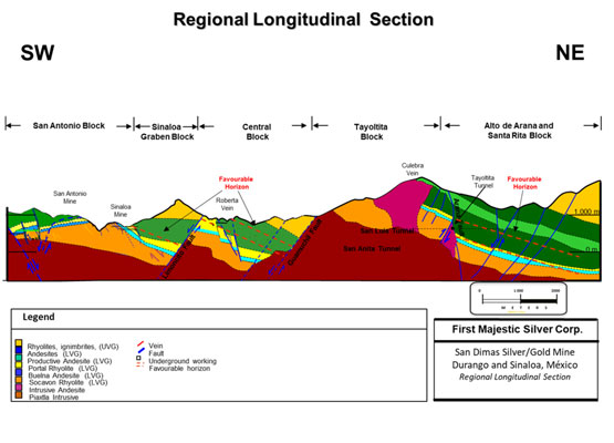
Note: Figure prepared by First Majestic, after Goldcorp.
| 7.2. | Mineralization |
Within the San Dimas district, the mineralization is typical of epithermal vein structures with banded and drusy textures. Epithermal-style veins occupy east–west-trending fractures, except in the southern part
| 54 | September 2025 |
| San Dimas Silver/Gold Mine Durango and Sinaloa States, Mexico NI-43-101 Technical Report on Mineral Resource and Mineral Reserve Estimates |
|
of the Tayoltita Block where they strike mainly northeast, and in the Santa Rita area where they strike north–northwest (see Section 7.4 for block and area descriptions).
The Favourable Zone concept for San Dimas was developed in the mid-seventies in the Tayoltita Block, based on the San Luis vein, which was mined out in the late 1990s. The mine geologists observed that bonanza grades along the San Luis vein were spatially related to the Productive andesite unit and/or to the interphase between the Productive andesite and the Portal rhyolite and/or the Buelna andesite. This spatial association of vein-hosted mineralization to a favorable zone within the volcanic sequence is now recognized in other fault blocks and constitutes a major exploration criterion for the district.
The veins were formed in two distinct phases. The east–west striking veins developed first, followed by a second system of north–northeast-striking veins. Veins pinch and swell and commonly exhibit bifurcation, horse-tailing, and sigmoidal structures. They vary in width from a fraction of a centimeter to as much as 8 m wide, but average 1.5–2.0 m. The veins have been followed underground from a few meters in strike-length to more than 1,500 m. An example of these veins, the Jessica Vein, which extends for more than 1,000 m in the Central Block, is illustrated in Figure 7-7.
Figure 7-7: The Jessica Vein Within the Favourable Zone, Vertical Section
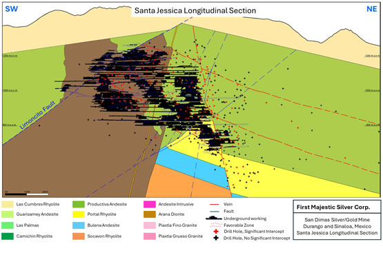
Note: Black dots represent exploration and delineation drilling intercepts. The Favorable Zone, the interphase between Productive andesite and rhyolite, is positioned between the two red dotted lines. Figure prepared by First Majestic, April 2025.
Three major stages of mineralization have been recognized in the district:
| 55 | September 2025 |
| San Dimas Silver/Gold Mine Durango and Sinaloa States, Mexico NI-43-101 Technical Report on Mineral Resource and Mineral Reserve Estimates |
|
| • | Early stage; |
| • | Mineralization-forming stage; |
| • | Late-stage quartz. |
These three distinct sub-stages of the mineralization-forming stage can be discriminated by distinctive mineral assemblages with ore-grade mineralization occurring in all three sub-stages:
| • | Quartz–chlorite–adularia; |
| • | Quartz–rhodonite; |
| • | Quartz–calcite. |
The paragenetic sequence for vein formation is summarized in Figure 7-8.
Figure 7-8: Paragenetic Vein Sequence, San Dimas
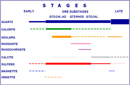
Note: Figure prepared by Silver Wheaton (now Wheaton Precious Metals), after Clarke, 1986; and Enriquez, 1995. QTZ=quartz, CHL=chlorite, AD=adularia, RHOD=rhodochrosite, CAL= calcite
The mineral-forming vein stage mineralogy consists primarily of white to light grey, medium-to-coarse-grained crystalline quartz. The quartz contains intergrowths of base metal sulphides (sphalerite, chalcopyrite, and galena) as well as pyrite, argentite, polybasite [(Ag,Cu)6(Sb,As)2S7], stromeyerite (AgCuS), native silver, and electrum. The veins are formed by filling previous fractures and typical textures observed include crustification, comb structure, colloform banding and brecciation. Figure 7-9 is a photograph of the Roberta vein, San Dimas.
| 56 | September 2025 |
| San Dimas Silver/Gold Mine Durango and Sinaloa States, Mexico NI-43-101 Technical Report on Mineral Resource and Mineral Reserve Estimates |
|
Figure 7-9: Roberta Vein, Central Block, San Dimas
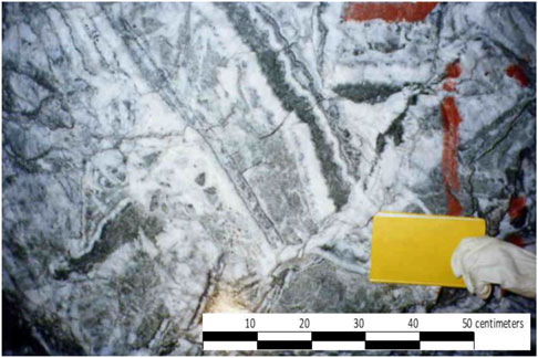
Note: Photo by First Majestic.
Mineralized shoots within the veins have variable strike lengths (5–600 m); however, most average 150 m in strike-length. Down-dip extensions of mineralized shoots are up to 200 m in length and are generally less than the strike length.
| 7.3. | Deposit Descriptions |
More than 125 mineralized quartz veins have been recognized across the San Dimas property. Table 7-1 presents the list of significant mineralized veins by mine zone, which are commonly defined by the major fault blocks.
| 57 | September 2025 |
| San Dimas Silver/Gold Mine Durango and Sinaloa States, Mexico NI-43-101 Technical Report on Mineral Resource and Mineral Reserve Estimates |
|
Table 7-1: List of Major Veins by Mine Zone in the San Dimas Property District
| Veins per mine zone | ||||||||||||||||||
|
West Block |
Graben Block | Central Block | Tayoltita Block | Santa Rita Area | El Cristo Area | Alto Arana Area | San Vicente Area | Ventanas | ||||||||||
|
Esperanza |
Santa Regina |
Santa Jessica |
San Francisco |
732 (Tay) |
Promontorio |
Guadalupe |
Alto Arana |
San Juan |
Rivereña |
|||||||||
|
San Rafael |
Trinidad |
Noche Buena |
Cedral |
710 (Tay) |
Blendita |
El Cristo Area |
San Vicente |
Eleonor |
||||||||||
|
Tescalama |
Alexa |
Frapopan |
930 |
Escondida |
Liliana |
Camichin |
Guadalupe |
|||||||||||
|
Coronado |
Victoria |
Pozolera |
300_8000 (Tay) |
5 Señores |
San Pablo |
Veta Nueva |
El Carmen |
|||||||||||
|
Escobosa |
Lilith-Paula |
Roberta |
Culebra |
Laura |
Carrizo |
Tejas |
Valenciana |
|||||||||||
|
Sta. Teresa |
Aranza |
San Enrique |
Candelaria |
Guadalupe |
San Jose |
Verdosa |
Mala Noche |
|||||||||||
|
San Antonio |
Elia |
Robertita |
San Luis |
Yadira |
Carolina |
El Reliz |
La Prieta |
|||||||||||
|
Guadalupe |
Franklin |
Marina 1 |
Maria Elena |
300_8001 (Tay) |
Nancy |
|||||||||||||
|
Carmen |
Marina 2 |
Itzel |
550 (Tay) |
Cristina |
||||||||||||||
|
Rosario |
Gloria |
207 (Tay) |
607 (Tay) |
Marisa |
||||||||||||||
|
Peggy |
Jael |
Perlita |
615 (Tay) |
Patricia II |
||||||||||||||
|
Macho Bayo |
Gabriela |
326 (Tay) |
623 (Tay) |
Patricia II |
||||||||||||||
|
Enik |
Soledad |
Elisa_26 |
636 (Tay) |
Magdalena |
||||||||||||||
|
Perez |
Castellana |
Aurora |
638 (Tay) |
Trinidad |
||||||||||||||
| San Jose |
Celia |
Catalina (Tay) |
640 (Tay) |
Santa Rita |
||||||||||||||
|
Marshall |
San Salvador |
Don Eduardo |
653 (Tay) |
Tecolota |
||||||||||||||
|
Carmen |
Santa Gertrudis |
Clarisa (Tay) |
714 (Tay) |
El Sol |
||||||||||||||
|
Pinito |
Santa Lucia |
Luz-María |
900 (Tay) |
La Luna |
||||||||||||||
| El Oro |
Lidia Marcela |
Marcela_314 |
America |
|||||||||||||||
| Angelica |
711 (Tay) |
25_178 (Tay) |
||||||||||||||||
| San Felipe |
715 (Tay) |
Frontera |
||||||||||||||||
|
Arana |
||||||||||||||||||
|
18 |
8 |
21 |
21 |
22 |
19 |
7 |
1 |
2 |
7 |
|||||||||
| 58 | September 2025 |
| San Dimas Silver/Gold Mine Durango and Sinaloa States, Mexico NI-43-101 Technical Report on Mineral Resource and Mineral Reserve Estimates |
|
The local geology is characterized by north–northwest–south–southeast-oriented fault blocks that are bounded by major faults. The veins are generally oriented west–southwest to east-northeast-oriented, within corridors up to 10 km wide. The veins are commonly truncated by the north–northwest–south–southeast-trending major faults, which separate the original veins into segments. These segments are named as individual veins and grouped by mine zones by corresponding fault block.
These mine zones are, from west to east: West Block, Graben Block, Central Block, Tayoltita Block, Alto de Arana Block (also known as Arana HW), San Vicente, El Cristo and Santa Rita. Figure 7-10 shows the location of the major veins within the mine zones at San Dimas .
Figure 7-10: San Dimas Vein Distribution by Mine Zone
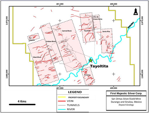
Note: Figure prepared by First Majestic, April 2025.
A description for each of the mine zones is presented in the following sub-sections. Figure 7-11 shows the location of the major veins across San Dimas and the position of representative cross sections, which are detailed in the following sections.
| 59 | September 2025 |
| San Dimas Silver/Gold Mine Durango and Sinaloa States, Mexico NI-43-101 Technical Report on Mineral Resource and Mineral Reserve Estimates |
|
Figure 7-11: Vein Map, San Dimas
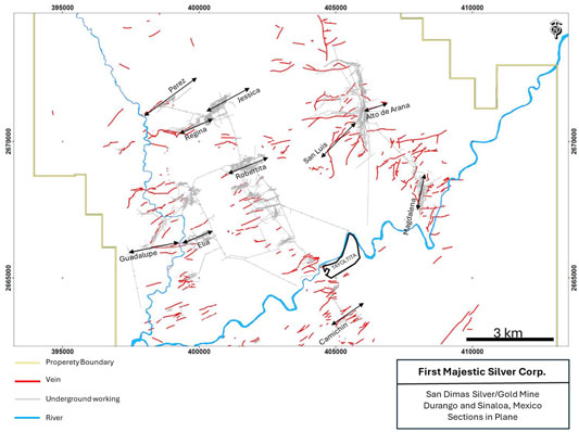
Note: Representative cross sections for each mine zone are highlighted. Figure prepared by First Majestic, April 2025.
| 7.3.1. | West Block |
The West Block is limited to the west by the Don Porfirio Fault and to the east by the Sinaloa Fault. It covers an area of 2,700 m in the northeast–southwest direction and 7,700 m in the southeast–northwest direction. In this approximately 21 km2 of surface, a total of 17 veins have been identified to date. The veins are hosted by the Portal rhyolite and Productive andesite stratigraphic units and andesitic intrusions.
The strike direction of the veins in this block is east–northeast–west–southwest, dipping at 30–60° to the northwest. The highest vein in elevation is San Rafael, located at 1,100 masl; and the lowest is Santa Rosa vein at 340 masl. The strike length varies from 100–500 m. The average thickness is 1.5 m, the distance between veins varies between <80 m to 300 m. The Perez vein contributes significant resources to the of the LOM.
Figure 7-12 shows a longitudinal section for the Guadalupe and Perez veins in the West Block.
| 60 | September 2025 |
| San Dimas Silver/Gold Mine Durango and Sinaloa States, Mexico NI-43-101 Technical Report on Mineral Resource and Mineral Reserve Estimates |
|
Figure 7-12: Longitudinal section, Guadalupe and Perez Veins, West Block, San Dimas
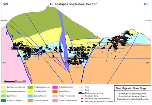
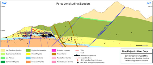
Note: Significant intercepts > 0.7m @ > 215 g/t AgEq. Figure prepared by First Majestic, April 2025.
| 61 | September 2025 |
| San Dimas Silver/Gold Mine Durango and Sinaloa States, Mexico NI-43-101 Technical Report on Mineral Resource and Mineral Reserve Estimates |
|
| 7.3.2. | Graben Block |
The Graben Block is limited to the west by the Sinaloa Fault and to the east by the Limoncito Fault. It covers an area of 1,200 m in the northeast–southwest direction and 6,000 m in the southeast–northwest direction. Within this approximately 7 km2 area, a total of eight veins have been identified. The veins are hosted by the Portal rhyolite and Productive andesite stratigraphic units and dioritic rocks.
The strike for most of the veins is northeast–southwest dipping from 30–90° to the northwest. The highest vein in elevation is Santa Regina, located at 1,060 masl and the lowest is Victoria at 250 masl. The strike length varies from 100–1000 m. The average thickness is 2 m, and the distance between veins varies from <100 m to 300 m.
Figure 7-13 shows a longitudinal section for the Elia vein in the Graben Block.
Figure 7-13: Longitudinal Section, Elia Veins, Graben Block, San Dimas
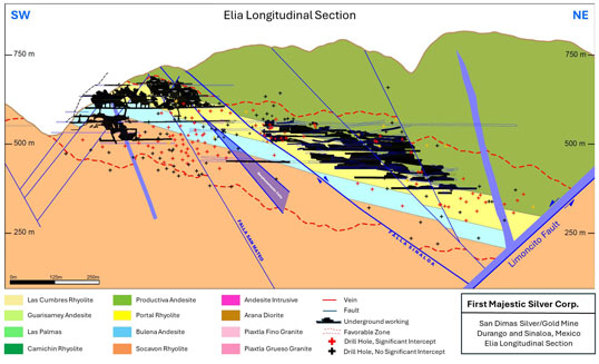
Note: Significant intercepts > 0.7m @ > 215 g/t AgEq. Figure prepared by First Majestic, April 2025.
| 62 | September 2025 |
| San Dimas Silver/Gold Mine Durango and Sinaloa States, Mexico NI-43-101 Technical Report on Mineral Resource and Mineral Reserve Estimates |
|
| 7.3.3. | Central Block |
The Central Block is limited to the west by the Limoncito Fault and to the east by the Guamuchil Fault. It covers an area of 3,200 m in the northeast–southwest direction by 8,500 m in the southeast–northwest direction. Within the block, a total of 21 veins have been identified in the last two decades. The veins are hosted by the Portal rhyolite and Productive andesite stratigraphic units and intrusive dioritic rocks.
Two significant veins in the Central Block are the Roberta and Robertita veins, which are 1,500 long by 500 m high by 2.5 m average thickness. These two veins are almost mined out. The veins in Central Block show northeast–southwest strike direction, dipping to the northwest. In terms of elevation the highest vein is Santa Jessica at 1,231 masl and the lowest is Robertita at 110 masl. Within the veins, the high-grade mineralized shoots generally plunge to the northeast. The distance between veins varies from <100 m to 500 m.
Figure 7-14 shows a longitudinal section for the Robertita vein in the Central Block.
Figure 7-14: Longitudinal Section, Robertita Vein, Central Block, San Dimas
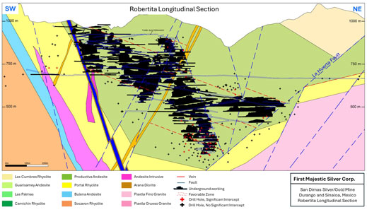
Note: Significant intercepts > 0.7m @ > 215 g/t AgEq. Figure prepared by First Majestic, April 2025.
| 7.3.4. | Tayoltita Block |
The Tayoltita Block, also known as the East Block, is limited to the west by the Guamuchil Fault and to the east by the Arana Fault. It covers an area of 1,800 m in the northeast–southwest direction and 3,500 m in the southeast–northwest direction. Within the block, a total of 43 veins have been identified. The veins are hosted by the Portal rhyolite and Productive andesite stratigraphic units and andesitic intrusions.
| 63 | September 2025 |
| San Dimas Silver/Gold Mine Durango and Sinaloa States, Mexico NI-43-101 Technical Report on Mineral Resource and Mineral Reserve Estimates |
|
The largest vein in this block was San Luis vein, which was mined out in the past. The highest vein in elevation is San Luis, located at 1,900 masl; and the lowest is Vein-36, which is at 470 masl. The strike length varies from 80–1,800 m and the average thickness is 1.5 m. The distance between veins varies from <100 m to 350 m.
Figure 7-15 shows a longitudinal section for the San Luis vein in the Tayoltita Block.
Figure 7-15: Longitudinal Section, San Luis Vein, Tayoltita Block, San Dimas
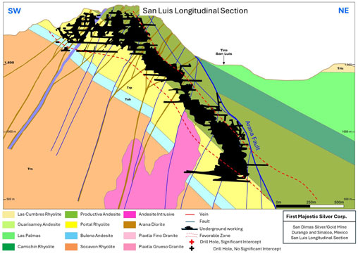
Note: Figure prepared by First Majestic, April 2025.
| 7.3.5. | Santa Rita Area |
The Santa Rita area is between the Peña Fault and the Piaxtla river, located in the eastern side of the property. It covers an area of 1,700 m in the northeast–southwest direction and 3,500 m in the southeast–northwest direction. In this approximately 6 km2 of surface area, a total of 19 veins have been identified. The veins are hosted by Portal rhyolite, Productive andesite, and Camichin stratigraphic units.
The veins are northeast–southwest-oriented, dipping from 20–90°. The highest vein in elevation is Promontorio, located at 930 masl and the lowest is the Marisa vein at 300 masl. The strike length varies from 80–250 m. The vein thickness varies from 0.3–3.0 m, and the distance between veins varies from <100 m to 400 m.
| 64 | September 2025 |
| San Dimas Silver/Gold Mine Durango and Sinaloa States, Mexico NI-43-101 Technical Report on Mineral Resource and Mineral Reserve Estimates |
|
Figure 7-16 shows a longitudinal section for the Magdalena vein in the Santa Rita Area.
Figure 7-16: Longitudinal Section, Magdalena Vein, Santa Rita Area, San Dimas
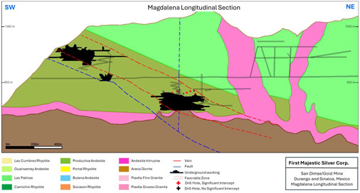
Note: Significant intercepts > 0.7m @ > 215 g/t AgEq. Figure prepared by First Majestic, April 2025.
| 7.3.6. | El Cristo Area |
The El Cristo area is located south of the Piaxtla River. It covers an area of 1,300 m in the northeast–southwest direction and 2,600 m in the southeast–northwest direction. Seven veins have been identified in the El Cristo area. The veins are hosted in the northern half by the Piaxtla granodiorite intrusion and in the southern half by the Productive andesite. The vein strike is northeast–southwest, dipping at 68° NW. The highest vein in elevation is Camichin, located at 1,160 masl and the lowest is the Gertrudis vein at 480 masl. The strike length varies from 70-300 m, the vein thickness varies from 0.5–1.3 m, and the distance between veins varies from <100 m to 300 m.
Figure 7-17 shows a longitudinal section for the Camichin vein in the El Cristo Area.
| 65 | September 2025 |
| San Dimas Silver/Gold Mine Durango and Sinaloa States, Mexico NI-43-101 Technical Report on Mineral Resource and Mineral Reserve Estimates |
|
Figure 7-17: Longitudinal Section, Camichin Vein, El Cristo Area, San Dimas

Note: Significant intercepts > 0.7m @ > 215 g/t AgEq. Figure prepared by First Majestic, April 2025.
| 66 | September 2025 |
| San Dimas Silver/Gold Mine Durango and Sinaloa States, Mexico NI-43-101 Technical Report on Mineral Resource and Mineral Reserve Estimates |
|
| 7.3.7. | Alto De Arana Area |
The Alto de Arana area is the northeastern part of the property and is located in the uplifted Arana fault block. The area is 900 m in the northeast–southwest direction and 1,500 m in the southeast–northwest direction. In this approximately 5.5 km2 surface area, a vein of the same name is the only vein system that has been identified to date. The Alto de Arana vein strikes north–south, dipping to the northeast. The vein was identified at 800 masl elevation and has an average thickness of 2.0 m.
Figure 7-18 shows a longitudinal section for the Alto de Arana vein in the Alto de Arana Area.
Figure 7-18: Longitudinal Section, Alto de Arana Vein, Alto de Arana Area, San Dimas
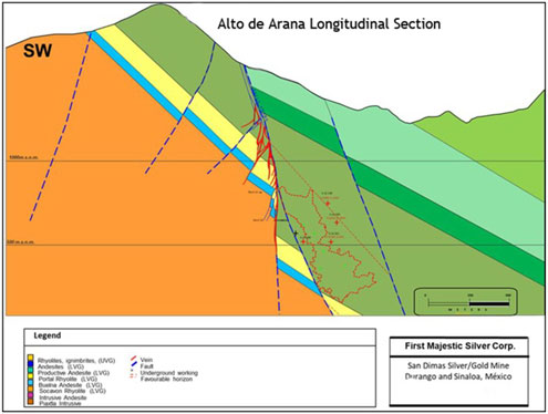
Note: Figure prepared by First Majestic, April 2025.
| 67 | September 2025 |
| San Dimas Silver/Gold Mine Durango and Sinaloa States, Mexico NI-43-101 Technical Report on Mineral Resource and Mineral Reserve Estimates |
|
| 7.3.8. | San Vicente Area |
The San Vicente area is located north of the West Block mine zone. It is the continuation of the West fault block, but for mining purposes the San Vicente Area has been kept separate. It covers an area of 1,500 m in the northeast–southwest direction and 800 m in the southeast–northwest direction. In this approximately 1.2 km2 of surface area, two veins have been identified. Both veins show a general northeast–southwest orientation dipping 65° NW and are hosted by Productive andesite. The highest vein in elevation is San Vicente vein at 1,275 masl and the lowest is San Juan vein at 810 masl. The strike length varies from 150–550 m, the vein thickness varies from 0.5–2.0 m, and the distance between the two veins is 80 m.
Figure 7-19 shows a longitudinal section for the Santa Regina—San Vicente vein in the San Vicente Area.
Figure 7-19: Longitudinal section, Santa Regina—San Vicente Vein, San Vicente Area, San Dimas
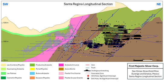
Note: Significant intercepts > 0.7m @ > 215 g/t AgEq. Figure prepared by First Majestic, April 2025.
| 68 | September 2025 |
| San Dimas Silver/Gold Mine Durango and Sinaloa States, Mexico NI-43-101 Technical Report on Mineral Resource and Mineral Reserve Estimates |
|
| 7.3.9. | Ventanas Prospect |
This area has been explored intermittently over the years since the 1970s, it is located in the southern end of the Sand Dimas property. The last major exploration campaign was in 2020. The quartz veins in the Ventana area are oriented east–west, dipping at 70°S (e.g., Rivereña, Eleonor, Guadalupe, El Carmen, and Valenciana veins) and northwest–southeast, dipping at 50°NE (e.g., Mala Noche and La Prieta veins). The largest vein is Mala Noche with a strike extent of more than 1,000 m and has been tested to 200 m depth by exploratory adits and drilling. The area holds exploration potential.
| 7.4. | Comments on Section 7 |
In the opinion of the QPs, the knowledge of the deposit settings, lithologies, mineralization style and setting, geological controls, and structural and alteration controls on mineralization is sufficient to support Mineral Resource and Mineral Reserve estimation.
| 69 | September 2025 |
| San Dimas Silver/Gold Mine Durango and Sinaloa States, Mexico NI-43-101 Technical Report on Mineral Resource and Mineral Reserve Estimates |
|
| 8. | MINERAL DEPOSIT TYPES |
The mineral deposits within the San Dimas property are examples of silver and gold-bearing epithermal quartz veins that formed in a low-sulphidation setting.
The description for the low-sulphidation epithermal model is taken from Pantaleyev (1996).
| 8.1. | Geological Setting |
Low-sulphidation epithermal mineral deposits are formed in high-level hydrothermal systems from depths of ~1 km to surficial hot spring settings. Deposition is controlled by regional- and local-scale fracture systems related to grabens, (resurgent) calderas, intrusive dome complexes and rarely, maar diatremes. Extensional structures in volcanic fields (normal faults, fault splays, ladder veins and cymoid loops, etc.) are common; locally graben or caldera-fill volcaniclastic rocks are present. High-level (subvolcanic) stocks and/or dikes and pebble breccia diatremes occur in some areas. Locally resurgent or domal structures are related to underlying intrusive bodies.
Most volcanic rocks can host epithermal deposits; however, calc-alkaline andesitic compositions are the most common. Some deposits occur in areas with bimodal volcanism and extensive subaerial ash flow deposits. A less common association is with alkalic intrusive and shoshonitic volcanic rocks. Epiclastic sediments can be associated with mineralization that develops in intra-volcanic basins and structural depressions.
Epithermal veins are typically localized along structures but may also form in permeable lithologies. Upward-flaring mineralized zones centred on structurally controlled hydrothermal conduits are typical. Large to small veins and stockworks are common. Vein systems can be laterally extensive, but the associated mineralized shoots have relatively restricted vertical extent. High-grade mineralized shoots are commonly formed within dilational faults zones near flexures and fault splays.
Textures typical of low-sulphidation quartz vein deposits include open-space filling, symmetrical and other layering, crustification, comb structure, colloform banding and complex brecciation.
| 8.2. | Mineralization |
Epithermal vein deposits commonly possess metal zoning along strike and vertically. Deposits are commonly zoned vertically over a limited 250–350 m extent from a base metal poor, gold–silver-rich top to a relatively silver-rich base metal zone and an underlying base metal-rich zone grading at depth into a sparse base metal, pyritic zone. From surface to depth, metal zones can contain gold–silver–arsenic–antimony–mercury, gold–silver–lead–zinc–copper, or silver–lead–zinc.
Pyrite, electrum, gold, silver, argentite; chalcopyrite, sphalerite, galena, tetrahedrite, silver sulphosalt and/or selenide minerals are common mineral species. Quartz, amethyst, chalcedony, quartz pseudomorphs after calcite, calcite; adularia, sericite, barite, fluorite, calcium–magnesium–manganese–
| 70 | September 2025 |
| San Dimas Silver/Gold Mine Durango and Sinaloa States, Mexico NI-43-101 Technical Report on Mineral Resource and Mineral Reserve Estimates |
|
iron carbonate minerals such as rhodochrosite, hematite, and chlorite are the most common gangue minerals.
| 8.3. | Alteration |
Silicification is extensive in epithermal vein-hosted mineral deposits as multiple generations of quartz and chalcedony are commonly accompanied by adularia and calcite. Pervasive silicification in vain envelopes can be flanked by sericite–illite–kaolinite assemblages. Intermediate argillic alteration (kaolinite–illite–montmorillonite) can form adjacent to some veins and advanced argillic alteration (kaolinite–alunite-pyrophyllite) may form along the tops of mineralized zones. Propylitic alteration dominates peripherally and at depth.
Figure 8-1 shows the genetic model for epithermal deposits proposed by Hedenquist et al., (1998).
Figure 8-1: Genetic Model for Epithermal Deposits
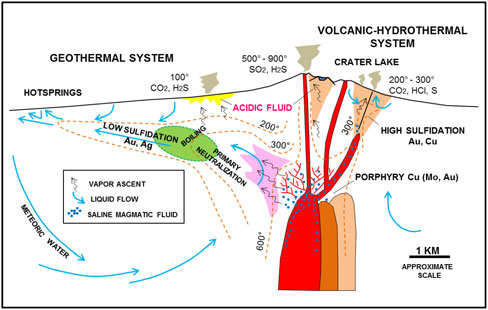
Note: Figure from Hedenquist et al., (1998).
| 8.4. | Applicability of the Low-Sulphidation Epithermal Model to San Dimas |
The vein-hosted silver and gold mineral deposits at San Dimas are considered to be low-sulphidation epithermal type deposits based on the following characteristics:
| • | Mineralization is deposited along a regional-scale extensional fault and fracture system; an environment typical of low sulfidation systems; |
| 71 | September 2025 |
| San Dimas Silver/Gold Mine Durango and Sinaloa States, Mexico NI-43-101 Technical Report on Mineral Resource and Mineral Reserve Estimates |
|
| • | The mineral deposits formed in the andesitic and rhyolitic volcanic rocks of the LVC; such rocks are typical host rocks for epithermal deposits; |
| • | Silver and gold mineralization are hosted by quartz veins that possess colloform and banded textures, typical of epithermal low sulphidation deposits. Additional structural–textural features, such as hydrothermal breccias cemented by quartz–calcite, stockworks, and cymoid loops, are also common; |
| • | The quartz veins possess a geochemical zonation in silver, gold, and base metals. Typically, the silver grades are higher closer to surface while base metals, particularly zinc, increase at lower levels in the system. Figure 8-2 shows the generalized geochemical model for the San Dimas deposits; |
| • | The veins are continuous along strike for distances up to 1,500 m; the original veins may have been several kilometers long, but these veins were truncated by post-mineral faulting; |
| • | Vertically, the vein-hosted mineralization is restricted within 75–650 m of the surface, which represents the high-level elevation where the second boiling zone occurs and locally has been called the Favorable Zone. Figure 8-3 shows a schematic section of the Favourable Zone using the Guadalupe vein as an example; |
| • | Dilatational zones serve as structural traps forming mineralized shoots, and the morphology of the veins in San Dimas is usually “pinch and swell.” |
Figure 8-2: Geochemical Zonation model San Dimas
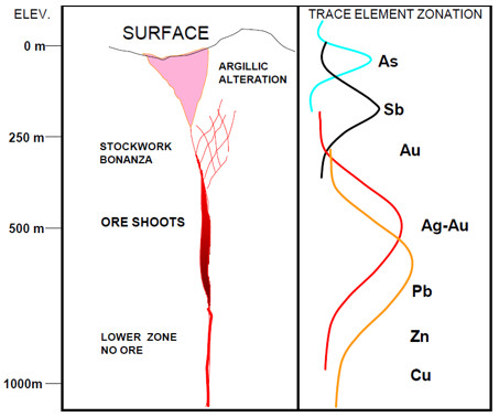
Note: Figure from Rivera, (2003).
| 72 | September 2025 |
| San Dimas Silver/Gold Mine Durango and Sinaloa States, Mexico NI-43-101 Technical Report on Mineral Resource and Mineral Reserve Estimates |
|
Figure 8-3: Example Section of the Favourable Zone for Mineralization, San Dimas
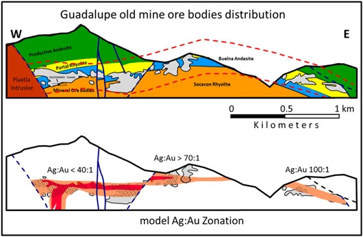
Note: Figure prepared by First Majestic, April 2025.
| 8.5. | Comments on Section 8 |
In the opinion of the QP, the deposits at San Dimas are examples of low sulfidation epithermal deposits. The QP believes that a low sulfidation epithermal model is appropriate as an exploration model for the San Dimas property and supports the geological interpretation and the geological modelling for Mineral Resource estimation.
| 73 | September 2025 |
| San Dimas Silver/Gold Mine Durango and Sinaloa States, Mexico NI-43-101 Technical Report on Mineral Resource and Mineral Reserve Estimates |
|
| 9. | EXPLORATION |
| 9.1. | Introduction |
The San Dimas district has been the subject of modern exploration and mine development activities since the early 1970s; a considerable information database has been developed from both exploration and mining activities. Exploration uses information from surface and underground mapping, sampling, and drilling together with extensive underground mine tunneling to help determine targets. Other activities include prospecting, geochemical surface sampling, geophysical, remote sensing surveys and artificial intelligence supported targeting.
Over the history of the district most of the exploration activities carried out at San Dimas property were centered around the Piaxtla River, where surface exposures of the silver–gold veins were found (Figure 9-1).
Figure 9-1: Location of Exploration Activities within the San Dimas Property
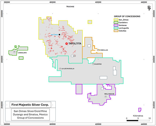
Note: Quartz veins highlighted in red. Figure prepared by First Majestic, April 2025.
| 74 | September 2025 |
| San Dimas Silver/Gold Mine Durango and Sinaloa States, Mexico NI-43-101 Technical Report on Mineral Resource and Mineral Reserve Estimates |
|
The Ventana area, located in the south of the property, was explored to some extent during 2020. The remainder of the property has had limited or no exploration as those areas are covered by post-mineral ignimbrites.
Figure 9-2 shows the areas subject to exploration at the San Dimas property during the last 50 years.
Figure 9-2: San Dimas Property, Areas Explored since 2020
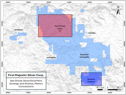
Note: Mining areas in red, exploration areas in dark blue. Figure prepared by First Majestic, April 2025.
| 9.2. | Grids and Surveys |
Prior to 2019, the operations used UTM NAD27, Zone 13N, for locations within the mine zones, and for drill collar purposes, and all plans related to that grid. First Majestic transitioned to UTM WSG84 in 2019.
| 9.3. | Geological Mapping |
| 9.3.1. | Surface Geological Mapping |
Approximately 60% of the San Dimas property is covered by post-mineral ignimbrites which overlie the units hosting silver and gold mineralization. Aerial photo interpretation was used in the mid-1970s to
| 75 | September 2025 |
| San Dimas Silver/Gold Mine Durango and Sinaloa States, Mexico NI-43-101 Technical Report on Mineral Resource and Mineral Reserve Estimates |
|
identify erosional windows through the ignimbrites that exposed the andesitic units of the LVC. The largest erosional window is centered on the Piaxtla River, which traverses the northern part of the property.
The andesite, rhyolite, and intrusive units exposed in the erosional window were of geological interest as they were associated with the favourable horizon and were mapped in detail. The geological mapping focused on identifying outcropping veins that were located on surface and projected at depth to be explored by tunneling and drilling. Regional-scale geological mapping was also conducted. Figure 9-3 shows the geological map produced during exploration of the San Dimas property.
Figure 9-3: Geological Map of the San Dimas Property
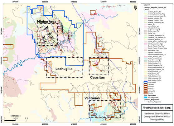
Note: Piaxtla River shown in blue. Figure prepared by First Majestic, April 2025.
Sparse detailed geological mapping existed outside the San Dimas mining area until 2005 when Capstone, through an option agreement with Goldcorp, carried out an exploration campaign in the Ventanas area, which had seen mining activity in the 1950s. Primero continued with the exploration work in this area and produced geological maps of the primary veins. Figure 9-4 shows the Ventanas geological map produced at 1:5,000.
| 76 | September 2025 |
| San Dimas Silver/Gold Mine Durango and Sinaloa States, Mexico NI-43-101 Technical Report on Mineral Resource and Mineral Reserve Estimates |
|
Figure 9-4: Geological Map, Ventanas Area
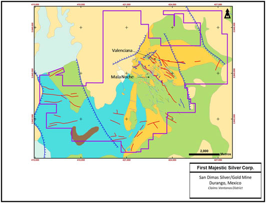
Note: Figure prepared by First Majestic, April 2025.
| 9.3.2. | Underground Geological Mapping |
Underground geological mapping is completed daily by mine geologists. It is a critical for exploration, geological interpretation, modeling, resource estimation, and the grade control process for the mine. Figure 9-5 shows an example of an underground geological map at 1:1,000 scale for the Perez vein.
| 77 | September 2025 |
| San Dimas Silver/Gold Mine Durango and Sinaloa States, Mexico NI-43-101 Technical Report on Mineral Resource and Mineral Reserve Estimates |
|
Figure 9-5: Geology Map generated during normal course of operation, Perez Vein
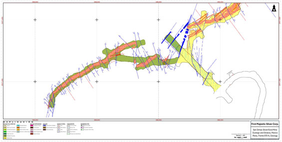
Note: Perez vein in red, faults in blue. Figure prepared by First Majestic, April 2025.
| 9.4. | Geochemical Sampling |
Multiple geochemical sampling campaigns have been completed at the San Dimas property. Current exploration includes surface mapping and rock chip sampling of potential vein extensions and/or areas with limited prior information.
The most common geochemical survey method is systematic rock chip channel sampling every 10–20 m along strike and perpendicular to outcropping veins. The sample intervals are variable, usually 1.0 m or less.
Samples are assayed, and the data plotted on geological maps. Where possible, trenching exposed the quartz veins for additional rock chip sampling. The geochemical anomalies are projected to depth to generate targets that were explored by drilling from surface, tunneling and/or underground drilling. Figure 9-6 shows the surface silver anomaly map in the San Dimas mining zone.
| 78 | September 2025 |
| San Dimas Silver/Gold Mine Durango and Sinaloa States, Mexico NI-43-101 Technical Report on Mineral Resource and Mineral Reserve Estimates |
|
Figure 9-6: Surface rock chip sampling, silver results map, San Dimas

Note: Figure prepared by First Majestic, April 2025.
Figure 9-7 shows the geology map and gold-equivalent anomalies in the Ventanas area produced by Primero during 2015–2016. Based on results from trenching at surface and underground sampling from the historic accessible mine levels, three veins were selected to be followed up with drilling: San Pedro, Mala Noche, and Macho Bayo. A total of 48 drill holes (15,600 m) were completed.
| 79 | September 2025 |
| San Dimas Silver/Gold Mine Durango and Sinaloa States, Mexico NI-43-101 Technical Report on Mineral Resource and Mineral Reserve Estimates |
|
Figure 9-7: Geological Map and Gold-Equivalent Anomalies, Ventanas Area
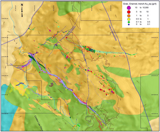
Note: Figure prepared by Primero Mining Corp.
| 80 | September 2025 |
| San Dimas Silver/Gold Mine Durango and Sinaloa States, Mexico NI-43-101 Technical Report on Mineral Resource and Mineral Reserve Estimates |
|
| 9.5. | Geophysics |
Limited geophysical surveys were completed due to a combination of the rugged terrain and the proven efficiency of the geochemical sampling methods to localize the favourable horizon.
In 2005, McPhar Geosurveys Ltd (McPhar) was engaged by Goldcorp to conduct a high-resolution airborne radiometric and magnetic survey over the San Dimas mining area to enhance the general understanding of the regional geology of the area. The flights were carried out by Heliservicios Internacionales, S. A. de C. V. using a Bell 206 Long Ranger helicopter.
The survey flight lines covered 2,261 km over an area of 203 km2. Spacing between points measured at ground level was 30 m for magnetic and 45 m for radiometric readings. The orientation of the flight was from north to south and the lines were flown with a 100 m spacing. Perpendicular flights, east to west, were done every kilometer.
The radiometric and magnetic collected data was processed by McPhar. Electromagnetic data were filtered and levelled using both automated and manual levelling procedures. Apparent resistivity was calculated from in-phase and quadrature data. The apparent resistivity dataset was also levelled and filtered. Radiometric data were processed using standard procedures recommended by International Atomic Energy Association.
All data were gridded with the cell size of 30 m. Figure 9-8 shows the magnetic field reduced to pole. The interpretation identified intrusive bodies such as Arna, Piaxtla, the Intrusive andesite, and seven areas of prospective interest tagged as A, B, C, D, E, F and G.
| 81 | September 2025 |
| San Dimas Silver/Gold Mine Durango and Sinaloa States, Mexico NI-43-101 Technical Report on Mineral Resource and Mineral Reserve Estimates |
|
Figure 9-8: Magnetic Field Reduced to Pole, San Dimas
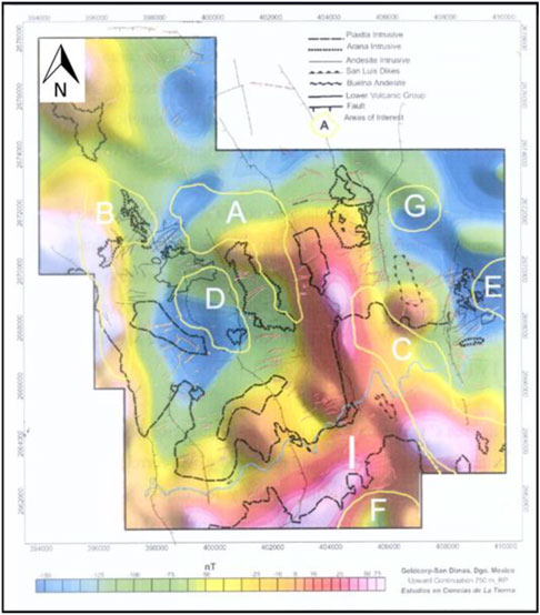
Note: Figure prepared by Goldcorp Mexico, 2005.
| 9.6. | Remote Sensing |
ASTER imagery covering the San Dimas mining area was acquired in 2002 by Wheaton River. The image was crosstalk corrected, processed to surface reflectance, and analyzed. The objective was to outline structural and alteration features that could be related to mineralization in the district.
| 82 | September 2025 |
| San Dimas Silver/Gold Mine Durango and Sinaloa States, Mexico NI-43-101 Technical Report on Mineral Resource and Mineral Reserve Estimates |
|
In 2013, Primero compiled historical remote sensing data, which included previous airborne magnetic and radiometric data acquired in 2005 at 100 m line-spacing and the ASTER imagery acquired in 2002.
The objectives were to correlate the geophysical responses with observable structures and mineralization identified from field mapping in the district and identify interesting structural and alteration features that may be related to mineralization in the district.
Figure 9-9 shows the combination of the alteration map obtained from the ASTER image and the magnetic data. The inferred alteration zones tend to follow northeast-trending magnetic discontinuities.
Figure 9-9: Satellite Image Magnetic Tilt Derivative Inversion and Alteration, San Dimas
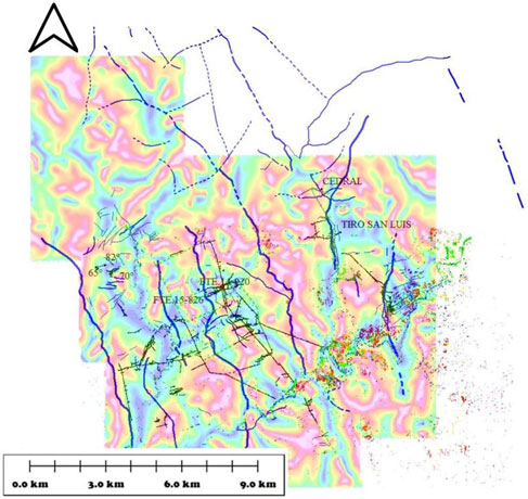
Note: Figure prepared by McPhar Geosurveys Ltd., December 2005.
| 9.7. | Tunnelling |
The most important, historic exploration strategy at San Dimas has been underground mine tunnelling from south to north since the favorable horizon concept was first proposed in 1975 by Luismin. Tunnelling
| 83 | September 2025 |
| San Dimas Silver/Gold Mine Durango and Sinaloa States, Mexico NI-43-101 Technical Report on Mineral Resource and Mineral Reserve Estimates |
|
consists of advancing mine development to the north at the preferred elevation to intersect quartz veins mapped at surface. This method discovered veins with no surface exposure, such as the Jessica vein. The tunnels were used to establish underground exploration drilling platforms, and to extract the mineralization. This exploration strategy has successfully been used by all companies after Luismin, resulting in more than 500 km of underground mine development. In recent years, the direct exploration methodology has been progressively replaced by drilling.
Figure 9-10: Main Mining Tunnels and Drill Hole Traces, San Dimas
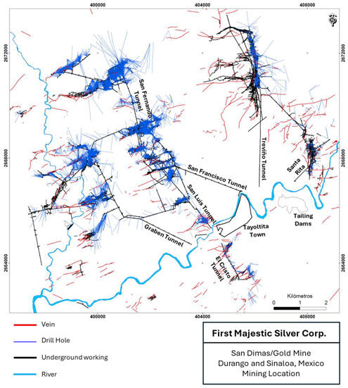
Note: Figure prepared by First Majestic, April 2025.
| 84 | September 2025 |
| San Dimas Silver/Gold Mine Durango and Sinaloa States, Mexico NI-43-101 Technical Report on Mineral Resource and Mineral Reserve Estimates |
|
| 9.8. | Petrology, Mineralogy, and Research studies |
Numerous petrographic studies have been conducted over the years by the different companies (e.g., Clarke et al., 1988; Petersen, 1997; Conrad et al., 1995; Enriquez et al., 2001; Montoya et al., 2020)
Between 2017 and 2020, Universidad Nacional Autónoma de Mexico, conducted a complete petrographic and fluid inclusions study as part of a Ph.D. thesis (Montoya, 2020). Samples were collected from the San Dimas mining areas as well as from the Ventanas area. Conclusions of this study are: “San Dimas exhibits multiple mineralization events during different magmatic and tectonic episodes from Late Cretaceous to early Oligocene. Mineralogical, fluid inclusions (FI), stable and noble gases isotope analyses suggest that the San Dimas mineralization consist of two different mineralization styles: 1) Ag-dominant epithermal Eocene veins that occurred at temperatures up to ~350 °C developed at ca. 2–3 km depth, associated to the final stages of intrusion of the Piaxtla batholith, with FI dominated by a crustal component, and 2) epithermal low sulfidation Au-dominant Oligocene veins which were developed at 250 °C, at shallower depths (< 1 km), associated to the feeding fractures of rhyolitic domes developed at the end of the main ignimbrite flare up of the Sierra Madre Occidental, with FI showing crustal fluids variably mixed with a magmatic component”.
| 9.9. | Exploration Potential |
The San Dimas property exploration potential is considered to remain open in all mine zones. Drilling searching for extension of mineralization in past producing veins has returned positive results in several areas. Additionally, as the mine was developed to the north, new veins were found with Perez (currently in production) being an example. South of the Piaxtla River, the El Cristo area has potential to host new vein discoveries. The West Block is currently being explored by tunnelling and drilling. Opportunities to intercept the projection of fault-offset quartz veins from the Graben and Central Blocks are considered good.
Exploration carried out in the Ventanas area, located in the southern end of the property, is not yet conclusive. Further exploration campaigns could result in more vein discoveries.
| 85 | September 2025 |
| San Dimas Silver/Gold Mine Durango and Sinaloa States, Mexico NI-43-101 Technical Report on Mineral Resource and Mineral Reserve Estimates |
|
| 10. | DRILLING |
Drilling in the San Dimas property is focused on the identification and delineation of vein-hosted silver and gold resources by using structural and stratigraphic knowledge of the district, and preferred vein trends. Since the Favourable Zone for mineral deposits concept emerged in 1975, the exploration strategy has focused on underground mining development and core drilling perpendicular to the preferred vein orientation within the mine zones, which has proven to be the most effective method of exploration in the area. Core drilling is predominantly done from underground stations, as the rugged topography (i.e., access to surface drill stations) and the great drilling distance from surface locations to the target(s) makes surface drilling challenging and expensive.
Over 1,413,000 m of core drilling have been completed since 2000.
| 10.1. | Drill Methods |
All drill holes at San Dimas are completed using diamond core drilling. No reverse circulation (RC) drilling has ever been conducted.
Prior to 2011, all drilling was classified as exploration drilling. From 2011 to 2020, drilling was classified as either delineation drilling, which was designed to potentially define the mineralization with target points located generally 25–40 m from development and in a 30 x 30 m pattern; or exploration drilling, which was designed to explore the extension of known veins and test new targets in a 60 x 60 m pattern.
Since January 2020, under First Majestic management, core drilling has been classified as:
| • | Operational drilling roughly aiming to convert Indicated to Measured Resources and de-risk mine plans; |
| • | Resource sustaining infill drilling, designed to provide support to upgrade resource classifications from Inferred to Indicated category. Infill drilling is often setup in a 30 x 30 m spaced pattern; |
| • | Near mine exploration drilling, designed to identify extensions of mineralization surrounding known mineral resources. This often consists of drilling along the extension of the known mineral deposits. The setup is often 60 x 60 m or more; |
| • | Brownfield exploration drilling, designed to identify mineralization outside of the existing mine plan that can use existing mine infrastructure; |
| • | Greenfield exploration drilling, designed to identify new discoveries that could require new mineral processing infrastructure. |
Core drilling included HQ (63.5 mm core diameter), NQ (47.6 mm), BQ (36.4 mm) and AQTT (27 mm). For drill holes longer than 700 m, HQ diameter is often reduced to BTW (42.01 mm).
“Termite” drill rigs have been used since 2009, are capable of drilling up to 150 m depth, and have been used mostly for Operational mine plan de-risking. The drilling barrel type used for this delineation drilling is TT46 producing core of 35 mm in diameter.
| 86 | September 2025 |
| San Dimas Silver/Gold Mine Durango and Sinaloa States, Mexico NI-43-101 Technical Report on Mineral Resource and Mineral Reserve Estimates |
|
Figure 10-1 is a plan view map of all drilling in the mine zones, more than 95% of all the drilling is within the San Dimas operation area.
Figure 10-1: Plan view of drilling at San Dimas
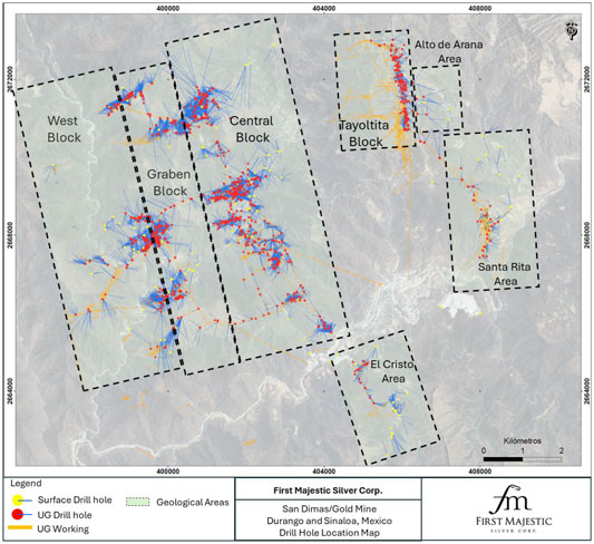
Note: Figure prepared by First Majestic, April 2025.
Drilling is focused on the identification and delineation of vein-hosted silver and gold mineralization by using structural and stratigraphic knowledge of the district, preferred vein trends, and Au:Ag ratios. These criteria have been successfully applied in the discoveries made after the early 1970s. Figure 10-2 is a vertical section example of drilling associated with the Perez vein.
| 87 | September 2025 |
| San Dimas Silver/Gold Mine Durango and Sinaloa States, Mexico NI-43-101 Technical Report on Mineral Resource and Mineral Reserve Estimates |
|
Figure 10-2: Vertical Section, Perez Vein
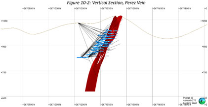
Note: Figure prepared by First Majestic, April 2025.
| 10.2. | Core Handling and Storage |
| • | Per the standard practice followed by First Majestic’s drillers and contractors, core is drilled in ~3.05 m runs (length of one drilling rod), placed onto a sample collector that matches the length of the run; core is broken when necessary to ensure pieces match the length of the core box and marked using coloured pencil at the place where it was broken; |
| • | Place the core into the core boxes, and then place a wooden block at the end of the run with the total depth of the hole and core length recovered in the run; |
| • | Mark hole ID and box number on the core boxes and lids, then once full, the core box is closed with a top lid and stacked for transportation. |
The core boxes are properly closed, and the box lids are secured with raffia fiber or rubber bands to prevent core from falling out of the box during transportation. Core boxes are transported and delivered to the core shed by drillers at the end of every shift (drillers work 12-hour shifts). The condition of the boxes, metre blocks and core are checked by one of the exploration geologists prior to core logging. Once the core boxes have been checked, the exploration technicians wash the core and inspect for out-of-sequence core pieces, mark every metre on the core, and labels depth intervals on core boxes and lids. Next the core is logged (recovery, rock quality designation (RQD), geotechnical and lithological logging), photographed, sampled, and afterward the core boxes are placed on racks within the secure environment of the core shed.
| 10.3. | Data Collection |
Data collected at San Dimas includes collar surveys, downhole surveys, logging (lithology, alteration, mineralization, structure, veins, sampling, etc.), specific gravity (SG), and geotechnical information. The data collection practices employed by First Majestic are consistent with mining industry standard exploration and operational practices.
| 88 | September 2025 |
| San Dimas Silver/Gold Mine Durango and Sinaloa States, Mexico NI-43-101 Technical Report on Mineral Resource and Mineral Reserve Estimates |
|
| 10.4. | Drill Hole Logging Procedure |
Historically, core was logged on paper on a columnar log and rock codes assigned at the time of data entry. Since 2013 the logged drill hole data are captured digitally using Core Logger.
Sampling is generally completed only on mineralized veins with an adequate interval of waste rock around the vein, with sample intervals placed on the contacts. The sample width is between 0.5–1 m. All core is labelled and photographed. The core is generally split for sampling with a diamond saw, although some softer rocks have been split using a hydraulic guillotine splitter. Samples are then bagged and tagged with sample identifiers, and since January 2019 are sent to First Majestic’s Central Laboratory (Central Laboratory). Prior to 2019, samples were shipped to the SGS laboratory based in Durango (SGS Durango).
| 10.5. | Core Recovery |
The rock quality at San Dimas is generally good in the mineralized intercept as well as in the wall rock. The core is received in the core shack and the pieces are reconstructed. The length of the core is measured and compared with the downhole length recorded in the core box.
A 95% recovery in the mineralized zone is considered acceptable, and the average recovery is 97%. Recoveries between 85% and 95% are usually related to fault zones, intensely altered zones, or rock cavities like vugs and geodes.
The QP reviewed the recovery data for drill holes and agrees with the Geology Department’s assessment of overall good recoveries.
| 10.6. | Collar Survey |
Collar coordinates and downhole azimuth and inclination are determined using total station equipment, before and after hole completion. The surveyors orient the rigs and provide proper initial alignment and inclination to the drilling rods. Collar locations are plotted and verified in plan view and cross section by geologists. This method is used in surface and underground drilling.
| 10.7. | Downhole Survey |
Goldcorp established a procedure in 2008 that continues to be used consisting of down hole azimuth and inclination readings using Reflex equipment first at 12 m and then every 30–50 m downhole depending on the inclination of the hole and the rock type. The geologist and the database manager validate the trace of the hole. This method has been used in surface and underground drilling.
| 10.8. | Geotechnical Drilling |
Geotechnical logging consists of descriptions of the fracturing degree of the mineralized veins and host rock on both sides of the vein contact, visual determination of the rock-quality designation (RQD) and rock
| 89 | September 2025 |
| San Dimas Silver/Gold Mine Durango and Sinaloa States, Mexico NI-43-101 Technical Report on Mineral Resource and Mineral Reserve Estimates |
|
resistance, and descriptions of the fracture types. This method has been used in surface and underground drilling.
| 10.9. | Specific Gravity and Bulk Density |
Bulk density measurements are systematically taken on 10 cm or longer whole core vein samples. From 2012 to 2023, specific gravity measurements were calculated using an unsealed water immersion method. The samples were weighed in air, recorded, then placed in a basket suspended in water and weight again recorded. Based on this method, an average bulk density value of 2.6 t/m3 was determined for veins. In 2015, SGS Durango determined a bulk density of 2.6 t/m3 based on analysis of 350 samples from various veins using a wax coat water immersion method. The regular SG measurements made by San Dimas geologists are used to check for variation from the 2.6 t/m3 bulk density value reported by SGS Durango.
Starting on 2024, density samples are dried first in air, weighed, coated with wax, and weighed again. The wax coated sample is then suspended in water and weighed again. The SG is estimated using the following formula:
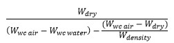
Where:
Wdry: Sample weight in dry in air.
Wwc air: Wax Coat sample weight in air.
Wwc water: Wax Coat sample weight immersed in water.
Wdensity: Density of wax.
Quality control samples such as duplicates, checks and standards are included.
| 10.10. | Drill Core Interval Length/True Thickness |
Drill holes are typically drilled to obtain the best intersection possible, such that the intersected interval is as close as possible to the true width, while giving vertical coverage. The minimum angle allowed to intercept the veins is 30°. This procedure is applicable to both surface and underground drilling.
As a result, the mineralized vein interval length observed in the drill holes does not correspond to the true thickness in most cases. The true thickness is determined by three-dimensional geological modeling and by noting the vein angle to the core axis.
| 90 | September 2025 |
| San Dimas Silver/Gold Mine Durango and Sinaloa States, Mexico NI-43-101 Technical Report on Mineral Resource and Mineral Reserve Estimates |
|
| 10.11. | Comments on Section 10 |
In the opinion of the QP, the quantity and quality of the lithological, geotechnical, structural, collar, and downhole survey data collected since 2000 are sufficient to support Mineral Resource and Mineral Reserve estimation.
| 91 | September 2025 |
| San Dimas Silver/Gold Mine Durango and Sinaloa States, Mexico NI-43-101 Technical Report on Mineral Resource and Mineral Reserve Estimates |
|
| 11. | SAMPLE PREPARATION, ANALYSES AND SECURITY |
| 11.1. | Sampling Methods |
| 11.1.1. | Core Sampling |
Since 2018, drill core sampling is undertaken by First Majestic’s geologists who select and mark sample intervals according to lithological contacts, mineralization, alteration, and structural features. Sample intervals range from 0.25–1.20 m in length from within mineralized structures and from 0.5–1.20 from hanging wall and footwall waste rock to obtain a minimum sample weight of 0.3–1 kg.
Drill core intervals selected for sampling are cut in half using a diamond saw. Softer rocks are split using a hydraulic guillotine splitter. One half of the core is retained in the core box for further inspection and the other half is placed in a sample bag. For smaller diameter delineation drill core (TT-46 “termite”) the entire core is sampled for analysis.
The sample number is printed with a marker on the core box beside the sampled interval, and a sample tag is inserted into the sample bag. Sample bags are tied with string and placed in rice bags for shipping.
| 11.1.2. | Underground Production Channel Sampling |
Prior to 2013, underground mine production channel samples for grade control and channel samples for resource estimation were taken across the roof at 1.5 m intervals in developments and at 3 m intervals in stopes using 3 m vertical cuts. From 2013–2016, production channel samples and channel samples for resource estimation were taken across the roof at 3 m intervals in developments and at 3 m intervals in stopes using 6–12 m vertical cuts. From 2016 to present, production channel samples for grade control and channel samples for resource estimation are routinely taken across the mine development face at approximately 3 m intervals and within stopes using 3–6 m vertical cuts.
Channel sampling for resource estimation is supervised by San Dimas geologists and undertaken using a hammer and chisel with a tarpaulin laid below to collect the samples. Sample lengths range from 0.20–1.20 m. Sample intervals are first marked with a line across the face perpendicular to the vein dip, respecting vein/wall contacts and textural or mineralogical features. The samples are taken as a rough channel along the marked line, with an emphasis on representative volume sampling. The sample is collected on the tarpaulin, broken with a hammer, and quartered and homogenized to obtain a ~3 kg sample. The sample is bagged and labelled with sample number and location details. Sketches and photographs are recorded of the face sampled, showing the samples’ physical location from surveying and the measured width of each sample. Since 2011, all channel samples are dispatched to the San Dimas Laboratory.
| 92 | September 2025 |
| San Dimas Silver/Gold Mine Durango and Sinaloa States, Mexico NI-43-101 Technical Report on Mineral Resource and Mineral Reserve Estimates |
|
| 11.2. | Analytical Laboratories |
The laboratories used for sample preparation and analysis are summarized in Table 11-1.
Table 11-1: Analytical Laboratories
| Laboratory | Drilling Period |
Certification | Independent | Comments | ||||
| San Dimas Laboratory | 2004–2024 | None | No | Primary laboratory for grade control, production channel samples, drillcore definition and pre-2011 drillcore. | ||||
|
Sample preparation and analysis. |
||||||||
|
Located at the San Dimas mine. |
||||||||
| SGS Durango | 2011–2024 | ISO 9001:2008 | Yes | Primary laboratory for exploration drill core, delineation drill core and production channel samples (2014-2018). Secondary laboratory for checks Assays (2021-2024). Sample preparation and analysis. Located in Durango, Durango state, Mexico. |
||||
| ISO/IEC 7025 |
||||||||
| ALS | 2013–2015 | ISO 9001 | Yes | Secondary laboratory for core check assays. Independent laboratory located in Zacatecas, Zacatecas state, Mexico. Sample Preparation and analysis. | ||||
|
2024 |
ISO/IEC 7025 |
|||||||
| Central Laboratory | 2018–2024 | ISO 9001 – 2008 in June 2015 and ISO 9001 - 2015 in June 2018 | No | Primary laboratory for exploration drill-core, delineation drill-core, and channel -check samples. | ||||
|
Sample preparation and analysis. |
||||||||
|
Located at Santa Elena Mine. |
||||||||
| 11.3. | Sample Preparation and Analysis |
| 11.3.1. | San Dimas Laboratory |
There is no detailed information describing sample preparation for channel and drill core samples applied at the San Dimas Laboratory before 2018. In general, the samples were dried, crushed, and pulverized. Since 2018, samples are dried at 110oC, crushed to 80% passing 2 mm using a Marcy jaw and Hermo crushers, split into 250-g subsamples using a Jones splitter, and pulverized using an ESSA pulveriser to 80% passing 75 µm. Before 2018, samples were analyzed for gold using a 10 g fire assay with a gravimetric finish. Since 2018, samples are analyzed for gold using a 30 g fire assay (FA) atomic absorption spectroscopy (AAS) method and by gravimetric finish if the doré bead is greater than 12 mg. Silver is determined using 30 g FA gravimetric finish. All samples received by the San Dimas Laboratory are logged into a laboratory information management system (LIMS).
| 93 | September 2025 |
| San Dimas Silver/Gold Mine Durango and Sinaloa States, Mexico NI-43-101 Technical Report on Mineral Resource and Mineral Reserve Estimates |
|
| 11.3.2. | SGS Durango |
At SGS Durango, drill core and channel check samples were dried at 105°, split to 3.5 kg, crushed 75% passing 2 mm, and split into a 250 g subsample which was pulverized to 85% passing 75 µm.
Between 2013 and 2024, drill core and channel check samples were analyzed for gold by a 30 g FA AAS method. Samples returning >10 g/t Au were reanalyzed by a 30 g FA gravimetric method. Silver was analyzed by a 2 g, three-acid digestion AAS method. Silver values >300 g/t or >100 g/t were analyzed by a 30 g FA gravimetric method. A multi-element suite was analyzed by a 0.25 g, aqua regia digestion inductively coupled plasma (ICP) optical emission spectroscopy (OES) method.
| 11.3.3. | Central Laboratory |
At First Majestic’s Central Laboratory located at the company’s Santa Elena Silver/Gold mine, Sinaloa, drill core and channel check samples are dried at 100oC for eight hours, crushed to 85% passing 2 mm, split into a 250 g subsample, and pulverized to 85% passing 75 µm.
Since 2018, drill core and channel check samples submitted to the Central Laboratory are analyzed for gold by 20g FA AAS method. Samples with gold values >10 g/t are reanalyzed by a 30 g, FA gravimetric method. Silver values are determined using a 2 g, three-acid digestion, AAS method. Samples with silver values >300 g/t or >200 g/t were analyzed by a 30 g, FA gravimetric method. Since 2024, samples with silver values >100 g/t are analyzed by 30 g, FA gravimetric method. All exploration samples are analysed by a two-acid multi-element ICP OES method.
| 11.3.4. | ALS |
In 2013, drill core check samples at ALS were assayed for gold and silver using a 30 g FA and gravimetric method. Since 2024, drill core check samples have been analyzed for gold by 30g fire assay fusion AAS method. Samples with gold values >10 g/t are analyzed by fire assay fusion gravimetric method. Silver values are determined using aqua regia digestion AAS analysis. Samples with silver values >100 ppm are analyzed by fire assay fusion gravimetric method.
Analytical methods by laboratory are summarized in Table 11-2.
| 94 | September 2025 |
| San Dimas Silver/Gold Mine Durango and Sinaloa States, Mexico NI-43-101 Technical Report on Mineral Resource and Mineral Reserve Estimates |
|
Table 11-2: Analytical Methods
| San Dimas | ||||||
| Code | Element | Limits | Description | |||
| ASAG-16 | Au g/t | 0.01 | 30 g, fire assay AAS finish. Gravimetric finish if doré bead is above 12 mg | |||
| ASAG-16 | Ag g/t | >5 | 30 g, fire assay gravimetric finish | |||
| AWAA-100 | Pb % | 0.002- 50 | 2-acid partial digestion by AAS. | |||
| SGS Durango | ||||||
| Code | Element | Limits | Description | |||
| GE FAA30V5 | Au g/t | 0.005-10 | 30 g, Au by fire assay, AAS finish. | |||
| GO_FAG303 | Au g/t | >1 | 30 g, Au by lead fusion fire assay gravimetric finish. Over limit method. | |||
| GO_FAG323 | Au g/t | 0.01 | 30 g, Au by lead fusion fire assay, AAS finish. | |||
| GE AAS33E50 | Ag g/t | 0.3-100 | 2 g, 3-acid digestion, AAS finish. | |||
| GO FAG37V | Ag g/t | >10 | 30 g, Ag by fire assay, gravimetric finish. | |||
| GE ICP21B20 | Ag ppm | 2-100 | 0.25 g, aqua-regia digestion ICP-OES. | |||
| GO_FAG323 | Ag g/t | >10 | 30 g, Au by lead fusion fire assay, gravimetric finish. | |||
| GE_AAS12E | Ag g/t | 0.3-100 | 2 g, 2-acid digestion, AAS finish. | |||
| GE ICP21B20 | Multi-element | Various | 0.25 g, aqua-regia digestion ICP-OES. | |||
| ALS | ||||||
| Code | Element | Limits | Description | |||
| ME-GRA21 | Au g/t | >0.05 | 30 g FA and gravimetric method. | |||
| ME-GRA21 | Ag g/t | >5 | 30 g FA and gravimetric method. | |||
| Au-AA23 | Au ppm | >10 | Fire assay fusion AAS. | |||
| Ag-AA45, AA46 | Ag ppm | 0.2-1500 | Ag by aqua regia digestion, AAS. | |||
| Central Laboratory | ||||||
| Code | Element | Limits | Description | |||
| AUAA-13 | Au g/t | 0.01-10 | 20 g fire assay with AAS finish. | |||
| ASAG-14 | Au g/t | >10 | 20 g fire assay gravimetric finish. Over limit method. | |||
| AAG-13 | Ag g/t | 0.5-250 | 2 g, 3-acid digest, AAS finish. | |||
| ASAG-12 | Ag g/t | >5 | 30 g, fire assay gravimetric finish. | |||
| ICP34BM | Multi-element | Various | 2-acid partial digestion ICP. | |||
| 11.4. | Quality Assurance and Quality Control (QAQC) |
| 11.4.1. | Materials and Insertion Rates |
There is limited information as to whether a formal quality assurance and quality control (QAQC) program was in place prior to 2013.
From 2013 to 2018, the QAQC program for the San Dimas Laboratory samples included insertion of an In-house standard reference material (SRM) and a coarse blank in every batch of 20 samples.
| 95 | September 2025 |
| San Dimas Silver/Gold Mine Durango and Sinaloa States, Mexico NI-43-101 Technical Report on Mineral Resource and Mineral Reserve Estimates |
|
From 2013 to 2018, the QAQC program for the SGS Durango channel and core samples included insertion of a SRM and a coarse blank in every batch of 20 samples. In 2013, 5% of the coarse reject and pulp duplicates from core samples were randomly selected for analysis at SGS Durango and 5% of pulp checks from core samples were analyzed at ALS laboratory.
From 2019 to 2021, First Majestic revised the QAQC program to include insertion of three certified reference material (CRM) samples and three blanks in every batch of 50 channel samples analyzed at the San Dimas Laboratory and one CRM and two blanks in every batch of 26 drill core and channel check samples submitted to the Central Laboratory. Since 2022, the QAQC samples inserted channel samples include 4% coarse reject and pulp duplicates, 6% SRMs and CRMs and 4% pulp blanks. The QAQC samples inserted in the core sampling submitted to Central, SGS and San Dimas Laboratory include 6% field, coarse reject, and pulp duplicates, 6 % CRMs, and 3% coarse and 3% pulp blanks.
SRMs were prepared using material collected from a variety of vein deposits from San Dimas mining district. SGS Durango determined the expected value from a round-robin analysis by five laboratories.
Coarse blanks were prepared using material collected from andesitic and granitic intrusive outcrop near San Dimas. They did not undergo a round-robin analysis.
CRMs and pulp blanks were purchased from CDN Resource Laboratories Ltd. After 2024, pulp blanks were purchased from Sonora Naturals, a provider of laboratory material in Hermosillo.
| 11.4.2. | Transcription and Sample Handling Errors |
Before 2020, there were transcription errors identified at each laboratory. These errors were corrected. Since 2021, First Majestic routinely verify the data for transcription errors or for sample handling issues and sampling and logging procedures have been improved. Between 2021 and 2022, the amount of transcription errors was reduced and since 2023 no significant transcription errors or sample handling issues have been observed.
| 11.4.3. | Accuracy Assessment |
There is no detailed information describing assessment of accuracy from SRMs before 2013.
For samples analysed between 2014 and 2024, accuracy was assessed in terms of bias of the mean values returned for SRMs and CRMs relative to the expected value. A bias between ± 5 % is considered acceptable. SRM and CRM sample results for gold and silver were plotted on date-sequenced performance charts to investigate for outliers, defined as results that were above or below mean plus or minus three times the standard deviation and are related to sample swaps or transcription errors. Outliers are removed after assessing the final bias. Since 2014, the practice has been to re-assay outliers identified in areas of significant mineralization. There is no detailed information describing the re-assay of the outliers detected from assessments conducted between 2014 and 2020.
| 96 | September 2025 |
| San Dimas Silver/Gold Mine Durango and Sinaloa States, Mexico NI-43-101 Technical Report on Mineral Resource and Mineral Reserve Estimates |
|
San Dimas Laboratory
Between 2019 and 2020, First Majestic identified errors rating from 1% to 9% related to mislabeling of samples. After exclusion of these errors, SRMs for gold and silver showed an acceptable level of bias relative to the expected values. Since 2021, less than 9% errors have been identified and corrected. SRMs and CRMs results indicate acceptable bias for gold and silver.
SGS
The accuracy assessment from results reported by SGS between 2014 and 2020, identified very few errors such as mislabeling of samples. After exclusion of these errors, most of the CRM and SRM results for drill core and channel samples indicated no significant bias for gold and silver. A low bias for low-grade silver SRM inserted with channel samples show a constant marginal bias related to the difference between the analytical method used to obtain the refence value and the analytical method for silver used by SGS Laboratory. Since 2021, CRM results show acceptable bias.
Central Laboratory
During 2019 and 2020, the accuracy assessment showed that a few errors, such as mislabeling of samples, were identified for samples submitted to the Central Laboratory. After exclusion of these errors, CRMs for gold and silver show an acceptable level of bias relative to the expected values. One high-grade gold CRM shows a marginal but acceptable low bias. Since 2021, the CRMs results show acceptable bias for gold and silver.
An example of a time-sequence standard chart for the San Dimas Laboratory is provided as Figure 11-1. The period represented by the figure is for the year 2024.
| 97 | September 2025 |
| San Dimas Silver/Gold Mine Durango and Sinaloa States, Mexico NI-43-101 Technical Report on Mineral Resource and Mineral Reserve Estimates |
|
Figure 11-1: Example of 2024 High-Grade SRM Gold and Silver Standard Charts, San Dimas Laboratory
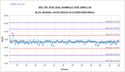
Total=118, #Outliers=0, Expected Val.=16.68, Mean=16.7146, SD=0.22, CV=0.0132, Bias of Mean=0.21%, 95%confInt=0.0397
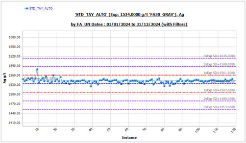
Total=118, #Outliers=0, Expected Val=1534, Mean=1543.3871, SD=6.4872, CV=0.0042, Bias of Mean=0.61%, 95%confInt=1.16
Note: Figure prepared by First Majestic, April 2025.
| 11.4.4. | Contamination Assessment |
There is no detailed information about monitoring contamination before 2013 sampling programs.
| 98 | September 2025 |
| San Dimas Silver/Gold Mine Durango and Sinaloa States, Mexico NI-43-101 Technical Report on Mineral Resource and Mineral Reserve Estimates |
|
From 2014 to 2020, contamination was assessed in terms of the values returned for blanks above two times the detection limit (failures) using sample number sequence performance charts.
Since 2021, contamination is assessed using coarse and pulp blanks. Blank results are plotted in a time-sequence blank performance chart. Coarse blanks returning results less than twice the detection limit value 80% of the time, and pulp blanks returning results less than twice the detection limit value 90% of the time are considered acceptable. Outliers related to sample swaps or transcription errors are removed before calculating the frequency. Batches with excessive blank failure rates are re-assayed.
San Dimas
Between 2013 and 2020 contamination at San Dimas Laboratory was assessed using coarse blanks, however there is no detailed information describing the re-assay of outliers. The failure rate before 2020 is as high as 11% and shows continuous improvement through 2021. The high failure rates were likely related to the quality of the coarse blank material that was discontinued in 2021. Since 2021, 80% of the coarse blank results and 90% of the pulp blank results are less than twice the detection limit. These results indicate no significant contamination for gold and silver.
SGS
From 2014 to 2020 contamination at SGS using coarse blanks inserted in the core and channel sample stream. The failure rate from this period ranges from 2% to 13%. Since 2021, 80% of the coarse blank results and 90% of the pulp blank results are less than twice the detection showing no significant contamination for gold and silver.
Central Laboratory
From 2019 to 2024, more than 90% of the coarse and pulp blanks gold and silver results were less than times the detection limit. The results indicate no significant contamination for silver and gold.
An example of pulp blank sequence performance charts for gold and silver results for 2024 is included as Figure 11-2.
| 99 | September 2025 |
| San Dimas Silver/Gold Mine Durango and Sinaloa States, Mexico NI-43-101 Technical Report on Mineral Resource and Mineral Reserve Estimates |
|
Figure 11-2: Example of 2024 Time Sequence Pulp Blank Performance Charts, San Dimas Laboratory
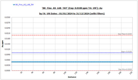
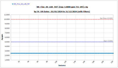
Note: Figure prepared by First Majestic, April 2025.
| 11.4.5. | Precision Assessment |
Before 2013, no duplicate samples were taken to evaluate precision. In 2013, 5% of pulp duplicates from core samples were re-assayed to assess precision at SGS. The pulp duplicate results indicated acceptable precision for gold and silver results. Since 2021, First Majestic assess precision from field, coarse reject and pulp duplicates inserted in the core samples and from coarse reject and pulp duplicates inserted in the channel samples. First Majestic assesses precision in terms of frequency of absolute relative difference (ARD) of paired duplicate values. Between 85% and 90 % frequency of ARD <30%, 20% and 10% for field,
| 100 | September 2025 |
| San Dimas Silver/Gold Mine Durango and Sinaloa States, Mexico NI-43-101 Technical Report on Mineral Resource and Mineral Reserve Estimates |
|
coarse and pulp duplicates is the target precision. Sample swaps and transcription errors are removed before assessing precision. Paired duplicate results, excluding outliers, are plotted on ARD versus frequency charts to visually inspect the sample frequency meeting the precision target. Duplicate precision is continually monitored and if precision targets are not met, the laboratories are consulted.
San Dimas Laboratory
Since 2021, pulp and coarse reject duplicate gold and silver results meet precision targets.
SGS
From 2021 to 2024, precision targets were met from coarse reject duplicate gold and silver results, and from pulp duplicate silver results. Pulp duplicate gold results were close to but did not meet the precision target. Field duplicates gold and silver results are lower than the precision target. The low precision from field duplicates is most likely attributable to the natural heterogeneity of the distribution of mineralization within the deposits.
Central Laboratory
Since 2022, pulp and coarse duplicate gold and silver results meet precision targets. Field duplicate gold and silver results do not meet the precision target. Precision from field duplicate silver results is generally higher than the precision from gold results.
| 11.4.6. | Between-Laboratory Bias Assessment |
From 2018 to 2020, channel duplicate samples were submitted to the Central Laboratory to provide a check on the original assays performed at the San Dimas Laboratory. These samples were also used for resource estimation. A reduced mean axis (RMA) analysis for paired channel samples collected from the Jael, Jessica, Regina, and Robertita veins between January 18, 2019 and January 20, 2020 (after removing outliers) indicates no significant inter-laboratory bias. Since 2022, pulp check samples from core and channel samples are sent regularly to an external independent laboratory to assess for between-laboratory bias. The RMA results indicate that there is no significant bias between Sand Dimas Laboratory and SGS and between Central Laboratory and SGS.
A summary of the 2023-2024 channel sample check results evaluating the potential for laboratory bias between San Dimas Laboratory and SGS is presented in Table 11-3. An example check chart is shown in Figure 11-3 for the 2023-2024 results.
Table 11-3: Summary of Inter-Laboratory Bias Check Results
| Element |
Count | Outliers | Bias | |||||||||
| Au |
273 | 7 | % | -3 | % | |||||||
| Ag |
262 | 4 | % | -4 | % | |||||||
| 101 | September 2025 |
| San Dimas Silver/Gold Mine Durango and Sinaloa States, Mexico NI-43-101 Technical Report on Mineral Resource and Mineral Reserve Estimates |
|
Figure 11-3: Between-Laboratory Bias Check, San Dimas and SGS Laboratories
Note: Figure prepared by First Majestic, April 2025.
| 102 | September 2025 |
| San Dimas Silver/Gold Mine Durango and Sinaloa States, Mexico NI-43-101 Technical Report on Mineral Resource and Mineral Reserve Estimates |
|
| 11.5. | Databases |
San Dimas drill hole and production channel data is stored in a secured SQL database, based on the Maxwell GeoServices database scheme. First Majestic received the assay data from the laboratories via emails in comma-separated value (CSV) data files. These files are compiled and imported using Maxwell’s DataShed™, a database management software. The import process includes a series of built-in checks for errors. After data are imported, visual checks are done to ensure that data were imported properly. Collar and lithology data is logged directly into a logging software or imported from Microsoft Excel into the database using Maxwell’s DataShed™.
| 11.6. | Sample Security |
| 11.6.1. | Channel Samples |
Throughout historical and current mine operations, channel samples have been transported from sampling areas to the San Dimas Laboratory by company trucks. The San Dimas Laboratory keeps the samples in a secured and fenced area during analysis. After analysis, samples are disposed of in the processing plant.
| 11.6.2. | Drill Core Samples |
Since the early drilling stages, drill core has been transported by personnel from First Majestic and predecessor companies and by drilling contractors’ trucks from drilling locations to a secured core storage warehouse where the core is logged and processed. The core storage warehouse is located at Tayoltita, 100 m from the airport terminal, and is currently secured and guarded by First Majestic security personnel.
Upon completion of logging and sampling, all samples are securely sealed, and chain of custody documents are issued for all shipments. Samples are transported to the external laboratory using a company contractor.
The analytical results from these samples are received by authorized First Majestic personnel using secure digital transfer transmissions, and these results are restricted to qualified First Majestic personnel until their publication.
Remaining drill-core and laboratory reject samples are stored at the core storage warehouse.
| 11.7. | Author’s Opinion and Other Comments on section 11 |
Sample preparation, analysis and quality control measures used at the primary and secondary laboratories meet current industry standards and are providing reliable gold and silver results. Sample security procedures used for transporting channel samples and drill core to the core warehouse and from the core warehouse to the laboratories are in accordance with industry standards. The database management procedure used to receive, and record results are providing reliable integrity to the samples results.
| 103 | September 2025 |
| San Dimas Silver/Gold Mine Durango and Sinaloa States, Mexico NI-43-101 Technical Report on Mineral Resource and Mineral Reserve Estimates |
|
Sample security procedures used are providing reliable integrity to the samples results. Current quality control procedures for SG sampling should be modified to include monitoring reports and a 5% check at a secondary laboratory using wax coat water immersion methods.
There is little information supporting sampling methods, sample preparation, and analysis for pre-2013 data. Pre-2013 data represents less than 2% of the database and therefore does not represent a material concern for overall data reliability informing the Mineral Resource estimates.
First Majestic is continually monitoring results and addressing issues as they occur. At the end of 2019, under Central Laboratory management, the San Dimas Laboratory received new equipment for sample preparation and analysis, revised sample preparation and analysis procedures, and provided employee training. All samples received by the San Dimas Laboratory are logged in and sorted by a LIMS. Assay results are reported using the LIMS and include results from inserted laboratory quality control samples.
Before 2019, production channel and drill hole samples used to support grade estimation were assessed for laboratory accuracy but were not assessed for laboratory precision. Since 2021, The QAQC insertions for production channel and drill hole samples include field, coarse and pulp duplicates to assesses precision.
Fifty percent of field duplicate pairs with gold and silver results achieve the precision threshold. The low precision from field duplicates is most likely attributable to the natural heterogeneity of the distribution of mineralization within the deposits. First Majestic will review the field duplicate sampling procedures to ensure that field duplicates are representative of the material being sampled. The low but acceptable precision observed at SGS from gold results indicates an issue with the sample preparation at SGS. To confirm appropriate quality and consistency in pulp grind size, a revision of the pulp preparation method at SGS is being evaluated.
The field sampling procedure for production channel samples has some risk of introducing sampling bias but this possible bias has not yet been assessed.
| 104 | September 2025 |
| San Dimas Silver/Gold Mine Durango and Sinaloa States, Mexico NI-43-101 Technical Report on Mineral Resource and Mineral Reserve Estimates |
|
| 12. | DATA VERIFICATION |
In 2011, AMC Mining Consultants (Canada) Ltd (AMC) completed data verification in support of the San Dimas 2011 Mineral Resource and Mineral Reserve estimation and identified several deficiencies, including issues with the mine laboratory. By 2013, San Dimas addressed these issues by submitting all new drill core and check channel samples to an independent commercial laboratory for preparation and analysis. A subsequent data review by AMC in 2013 concluded that the results were reasonable and suitable for supporting resource estimation at the time.
Data verification conducted by First Majestic before 2021 included a review of drill hole and channel sample data collected from the Jael, Jessica, Regina, and Robertita veins (the verification dataset). The most recent data verification includes data entry error checks, visual inspections of drillhole and channel data collected from between 2021–2024 from Elia, Rosario, El Oro, Aranza, Regina, Perez, Jael, Santa Teresa, and Castellana veins.
| 12.1. | Data Entry Error Checks |
The data entry error checks consisted of comparing data recorded in the database with original collar survey reports, lithology logs and assay reports, and investigation of gaps, overlaps and duplicate intervals in the sample and lithology tables. A 3% random selection of drillholes and channel samples indicates no significant data entry errors when comparing collar locations recorded in the database with original survey reports and topographic maps issued by First Majestic.
Logged attributes data were entered directly into the database through core logging software. An inspection for gaps, overlap, and duplicates identified no issues.
No significant data entry errors were observed in a 3% random selection of the gold and silver assay results of the verification dataset. The error check consisted of a comparison of the assays values recorded in the database with original electronic copies and final laboratory certificates issued by SGS Durango, Central and San Dimas laboratories. In addition, a random selection of high-grade gold and silver results were verified against the original laboratory certificates. No transcription errors were observed.
Three drill holes from the verification datasets were visually inspected. Observed lithology, mineralogy, sample lengths, and sample numbers were compared to the logged data. No significant differences were observed.
| 12.2. | Visual Data Inspection |
All drill hole collar and channel locations in the verification dataset were inspected in three dimensions by comparing drill hole locations with their relationship to underground topography. No significant position errors were observed.
| 105 | September 2025 |
| San Dimas Silver/Gold Mine Durango and Sinaloa States, Mexico NI-43-101 Technical Report on Mineral Resource and Mineral Reserve Estimates |
|
All downhole survey records in the verification dataset were inspected mathematically for angular deviation tolerance greater than 5°/30 m. No significant deviations were observed. Visual spot checks of five drill hole traces in three dimensions revealed no unusual kinks or bends.
A 3% random selection of lithology intervals of the verification datasets were visually inspected using core photos. Observed lithology, mineralogy, sample lengths and sample numbers were compared to the logged data. No significant differences were observed.
| 12.3. | Review QA/QC Assay Results |
Verification of assay accuracy and contamination is provided in Section 11 of this Technical Report.
| 12.4. | Site Visits |
Ms. María Elena Vázquez Jaimes, P.Geo., visited San Dimas on several occasions. Most recently, between July 3rd to July 11th, 2024. During these visits, Ms. Vázquez Jaimes reviewed current drill core and channel logging and sampling procedures and inspected drill core, core photos, core logs, and QAQC reports. She also undertook spot checks by comparing lithology records in the database with archived core. No significant issues were observed.
| 12.5. | QP’s Opinion and Other Comments on Section 12 |
The data verification completed by First Majestic identified no significant sample location, grade accuracy and contamination, or transcription error issues. The database is considered suitable to support Mineral Resource estimation.
Concerns identified by previous operators regarding the quality of data collected before 2013 are mitigated in part because only a small portion of the Mineral Resource estimates are supported by this data.
| 106 | September 2025 |
| San Dimas Silver/Gold Mine Durango and Sinaloa States, Mexico NI-43-101 Technical Report on Mineral Resource and Mineral Reserve Estimates |
|
| 13. | MINERAL PROCESSING AND METALLURGICAL TESTING |
| 13.1. | Overview |
San Dimas is an active mining operation where decades of consistent plant performance have superseded the original design test data as the primary basis for evaluating metallurgical outcomes.
| 13.2. | Metallurgical Testing |
Metallurgical and mineralogical testing is conducted regularly at San Dimas to support ongoing process optimization. Even when plant performance meets expectations, continuous testing is carried out to enhance metal recoveries and reduce operating costs. These programs support improvements in reagent use, particle size control, backwash circuit efficiency, and the evaluation of alternative reagents. The on-site Metallurgical Laboratory analyzes monthly composite samples to assess the metallurgical behavior of the plant feed and guide operational adjustments.
| 13.2.1. | Mineralogy |
Throughout the San Dimas property, the most abundant mineralogical species, both metallic and non-metallic include:
| • | Metallic minerals (in order of abundance): pyrite (FeS2), galena (PbS), chalcopyrite (CuFeS2), sphalerite |
| • | ((Zn, Fe)S), iron (Fe), argentite (Ag2S), native silver (Ag), hemimorphite (Zn4(Si2O7)(OH)2·H2O), and electrum; |
| • | Non-metallic minerals (in order of abundance): quartz (SiO2), chlorite ((Mg,Fe)3(Si,Al)4O10(OH)2-(Mg,Fe)3(OH)6), kaolinite (Al2Si2O5(OH)4), feldspar (KAlSi3O8 – NaAlSi3O8 – CaAl2Si2O8), and calcite (CaCO3). |
The typical mineralogy is provided in Figure 13-1.
| 107 | September 2025 |
| San Dimas Silver/Gold Mine Durango and Sinaloa States, Mexico NI-43-101 Technical Report on Mineral Resource and Mineral Reserve Estimates |
|
Figure 13-1: Typical Distribution of Minerals
Note: Figure prepared by First Majestic, April 2025.
| 13.2.2. | Monthly Composite Samples |
Daily and per-shift samples are collected from the material fed into the mills, with representative portions selected based on the tonnage processed each shift. These are combined to produce a monthly composite sample, prepared by the plant metallurgist in collaboration with the San Dimas Laboratory team. The primary goal of this program is to compare laboratory-scale results with actual plant performance, ensuring consistency and repeatability in metallurgical outcomes.
| 13.2.3. | Sample Preparation |
Samples submitted to the Central Laboratory are dried, and then crushed to -10 or 6 mesh, depending on the test work planned.
| 13.3. | Comminution Evaluations |
Since July 2018, First Majestic has been running tests to estimate the Bond ball mill work index (BWi) of the monthly composite samples.
Table 13-1 shows the results of the bond ball mill grindability test (at 270 mesh closing screen) for the period from June 2019 to February 2025.
| 108 | September 2025 |
| San Dimas Silver/Gold Mine Durango and Sinaloa States, Mexico NI-43-101 Technical Report on Mineral Resource and Mineral Reserve Estimates |
|
Table 13-1: Grindability Test Results for Different Composite Samples (2025)
| Sample ID | Bond Ball Mill Work Index | |||||||
| kWh/t Metric
200 M |
Feed µm
F80 |
Discharge µm
P80 |
||||||
| 2019 | June | 17.5 | 2,325 | 58 | ||||
| July | 17.8 | 1,920 | 58 | |||||
| August | 16.8 | 1,906 | 58 | |||||
| September | 15.5 | 2,217 | 58 | |||||
| October | 17.4 | 2,110 | 60 | |||||
| 2020 | April | 19.3 | 2,558 | 63 | ||||
| May | 19.7 | 2,582 | 61 | |||||
| June | 17.9 | 2,662 | 58 | |||||
| December | 17.5 | 2,524 | 55 | |||||
| 2021 | August | 19.7 | 2,612 | 55 | ||||
| 2022 | August | 19.2 | 2,411 | 75 | ||||
| 2023 | January | 17.1 | 2,747 | 52 | ||||
| February | 16.0 | 2,518 | 50 | |||||
| March | 15.9 | 2,343 | 53 | |||||
| July | 15.2 | 2,375 | 52 | |||||
| August | 16.5 | 2,385 | 52 | |||||
| 2024 | August | 15.1 | 2,398 | 50 | ||||
| September | 16.4 | 2,228 | 53 | |||||
| October | 16.5 | 2,401 | 53 | |||||
| November | 16.7 | 2,223 | 53 | |||||
| December | 16.6 | 1,907 | 53 | |||||
| 2025 | January | 16.0 | 2,283 | 52 | ||||
| February | 15.3 | 2,166 | 52 | |||||
| Statistics of the 23 Samples | ||||||||
| Average | 17.0 | |||||||
| Standard Deviation | 1.4 | |||||||
| Minimum | 15.1 | |||||||
| 25th Percentile | 16.0 | |||||||
| Median | 17.0 | |||||||
| 75th Percentile | 17.7 | |||||||
| Maximum | 19.7 | |||||||
The Bond Work Index (BWi) results exhibit low variability, with values ranging from 15.1 to 19.7 kWh/t. Additionally, analysis of the data indicates a slight downward trend in the work index values.
| 109 | September 2025 |
| San Dimas Silver/Gold Mine Durango and Sinaloa States, Mexico NI-43-101 Technical Report on Mineral Resource and Mineral Reserve Estimates |
|
| 13.4. | Cyanidation, Reagent and Grind Size Evaluations |
In addition to routine repeatability analyses of gold and silver recoveries using monthly composite samples, the San Dimas metallurgical team conducts a range of targeted tests to address operational challenges and drive ongoing optimization. These tests may include:
| • | Grind size evaluations – cyanidation tests at varying grind sizes to assess optimal particle size; |
| • | Reagent optimization – fine-tuning cyanide, lime, and dissolved oxygen levels to improve efficiency and reduce cost; |
| • | Residence time assessments – leach time variation tests to determine the ideal retention time for maximum recovery; |
| • | Evaluation of alternative reagents – including oxidants, eco-friendly options, and novel salts aimed at improving metallurgical performance. |
Test results are consistently shared with plant operations to inform continuous improvement efforts. As a demonstration of this integrated approach, Figure 13-2 illustrates a comparison between the mill’s monthly metallurgical recovery performance and laboratory results from the monthly composite samples for both gold and silver.
Figure 13-2: Comparison of Au Extractions Between Mill and Laboratory Performances
Note: Figure prepared by First Majestic, April 2025.
| 110 | September 2025 |
| San Dimas Silver/Gold Mine Durango and Sinaloa States, Mexico NI-43-101 Technical Report on Mineral Resource and Mineral Reserve Estimates |
|
Figure 13-3: Comparison of Ag Extractions Between Mill and Laboratory Performances
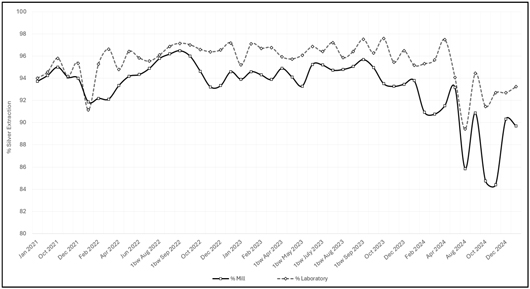
Note: Figure prepared by First Majestic, April 2025.
As shown, in months where the plant operated as expected (with gold recovery exceeding 95%), the average difference between laboratory and plant results was just 0.7% for gold, indicating strong alignment. For silver, the average difference was approximately 2.1%, reflecting areas of operational improvement within the plant.
| 13.5. | Optimizing Process Studies |
As part of the ongoing investigations focused on optimizing plant performance, a series of metallurgical tests have been conducted focusing on increasing sodium cyanide concentration, leach at finer particle sizes, and incorporating oxidizing reagents. These initiatives are in response to the presence of complex and sulfidic ore minerals bearing valuable metals.
The testwork was conducted using a master composite sample derived from a high-contribution ore feed area referred to as “Pérez,” which was delineated based on geometallurgical zoning and exploration drill hole data. Given the extensive size of the domain and the mineralogical variability associated with its genesis, the area was subdivided into two geometallurgical subdomains, designated as Pérez 1 and Pérez 2. Mineral Engineering & Consulting LLC performed the tests.
| 111 | September 2025 |
| San Dimas Silver/Gold Mine Durango and Sinaloa States, Mexico NI-43-101 Technical Report on Mineral Resource and Mineral Reserve Estimates |
|
Figure 13-4: Pérez Domain – Drilling Program
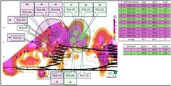
Note: Figure prepared by First Majestic, April 2025.
The figures illustrate a trend toward achieving improved metal recovery by increasing the sodium cyanide concentration in the leaching process from 2,500 ppm to a maximum of 4,000 ppm. All tests used leach times of 107 hours.
Figure 13-5: Comparison of Au Extractions Between Perez 1 & Perez 2
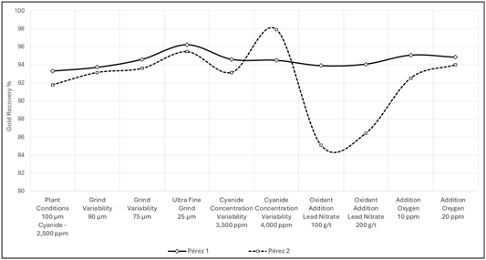
Note: Figure prepared by First Majestic, April 2025.
| 112 | September 2025 |
| San Dimas Silver/Gold Mine Durango and Sinaloa States, Mexico NI-43-101 Technical Report on Mineral Resource and Mineral Reserve Estimates |
|
Figure 13-6: Comparison of Ag Extractions Between Perez 1 & Perez 2
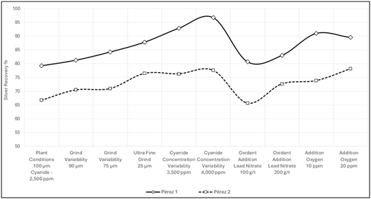
Note: Figure prepared by First Majestic, April 2025.
| 13.6. | Recovery Estimates |
The metallurgical recovery projections outlined in the LOM plan are supported by the historical performance of the processing plant. Based on plant performance data from 2021 to 2024, the estimated metal recoveries for the LOM plan and financial analysis are 92.6% for silver and 95.6% for gold. Table 13-2 presents the actual metallurgical recoveries achieved at the San Dimas processing plant over the past four years, though the last two years (2023 and 2024) were used in the LOM based on future material type and corresponding metallurgical testing.
Table 13-2: Metallurgical Recoveries achieved in San Dimas 2021-2024
| Year |
Production tonnes |
Recovery % Ag |
Recovery % Au |
|||||||||
| 2021 |
822,791 | 94.7 | % | 96.2 | % | |||||||
| 2022 |
787,635 | 93.9 | % | 96.3 | % | |||||||
| 2023 |
875,345 | 94.3 | % | 96.1 | % | |||||||
| 2024 |
776,811 | 89.9 | % | 94.7 | % | |||||||
|
|
|
|
|
|
|
|||||||
| Yearly Average |
815,646 | 93.2 | % | 95.8 | % | |||||||
|
|
|
|
|
|
|
|||||||
Figure 13-7 shows the historical monthly metallurgical recoveries recorded at the San Dimas processing plant.
| 113 | September 2025 |
| San Dimas Silver/Gold Mine Durango and Sinaloa States, Mexico NI-43-101 Technical Report on Mineral Resource and Mineral Reserve Estimates |
|
Figure 13-7: Historical Monthly Metallurgical Recovery of Gold and Silver from January 2021
to January 2025
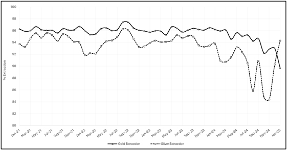
Note: Figure prepared by First Majestic, April 2025.
| 13.7. | Metallurgical Variability |
In 2023 and 2024, metallurgical laboratory tests were performed on material from 15 distinct geological domains using conditions that closely mirrored those of the beneficiation plant, including a target P80 of approximately 100 µm, cyanide concentration near 3,500 ppm, and retention times around 84 hours. Supplied by the Geology and Exploration departments, the samples included a mix of vein and host rock material, proportioned to reflect anticipated dilution during mining. The box plots below highlight the considerable variability in metallurgical behavior, illustrating wide-ranging head grades and recoveries for both gold and silver across the tested domains.
| 114 | September 2025 |
| San Dimas Silver/Gold Mine Durango and Sinaloa States, Mexico NI-43-101 Technical Report on Mineral Resource and Mineral Reserve Estimates |
|
Figure 13-8: San Dimas Box Plot of Gold Head Grades 2023

Note: Figure prepared by First Majestic, April 2025.
Figure 13-9: San Dimas Box Plot of Gold Recoveries Grades 2023
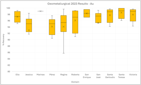
Note: Figure prepared by First Majestic, April 2025.
| 115 | September 2025 |
| San Dimas Silver/Gold Mine Durango and Sinaloa States, Mexico NI-43-101 Technical Report on Mineral Resource and Mineral Reserve Estimates |
|
Figure 13-10: San Dimas Box Plot of Silver Head Grades 2023
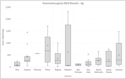
Note: Figure prepared by First Majestic, April 2025.
Figure 13-11: San Dimas Box Plot of Silver Recoveries 2023
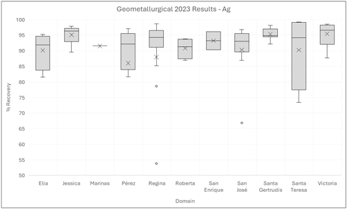
Note: Figure prepared by First Majestic, April 2025.
| 116 | September 2025 |
| San Dimas Silver/Gold Mine Durango and Sinaloa States, Mexico NI-43-101 Technical Report on Mineral Resource and Mineral Reserve Estimates |
|
Figure 13-12: San Dimas Box Plot of Gold Head Grades 2024
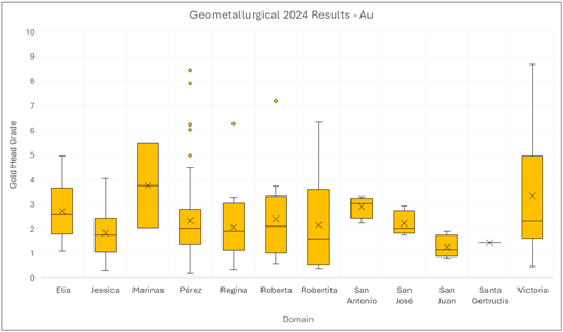
Note: Figure prepared by First Majestic, April 2025.
Figure 13-13: San Dimas Box Plot of Gold Recoveries 2024
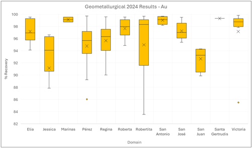
Note: Figure prepared by First Majestic, April 2025.
| 117 | September 2025 |
| San Dimas Silver/Gold Mine Durango and Sinaloa States, Mexico NI-43-101 Technical Report on Mineral Resource and Mineral Reserve Estimates |
|
Figure 13-14: San Dimas Box Plot of Silver Head Grades 2024
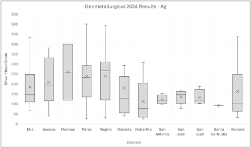
Note: Figure prepared by First Majestic, April 2025.
Figure 13-15: San Dimas Box Plot of Silver Recoveries 2024
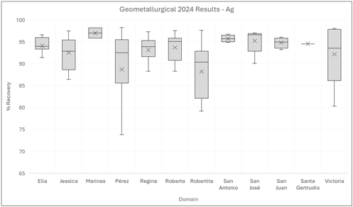
Note: Figure prepared by First Majestic, April 2025.
| 118 | September 2025 |
| San Dimas Silver/Gold Mine Durango and Sinaloa States, Mexico NI-43-101 Technical Report on Mineral Resource and Mineral Reserve Estimates |
|
| 13.8. | Deleterious Elements |
San Dimas doré consistently exceeds 97% purity (Au + Ag) and incurs no refinery penalties. Since March 2023, purity has surpassed 98% due to process improvements, including higher-purity zinc powder and optimized flux blends.
Figure 13-16: San Dimas Monthly Historical Doré Purity (Gold + Silver), 2021–2024
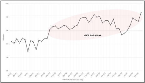
Note: Figure prepared by First Majestic, April 2025.
| 119 | September 2025 |
| San Dimas Silver/Gold Mine Durango and Sinaloa States, Mexico NI-43-101 Technical Report on Mineral Resource and Mineral Reserve Estimates |
|
| 14. | MINERAL RESOURCE ESTIMATES |
| 14.1. | Introduction |
This section describes the resource estimation methodology and summarizes key assumptions considered by First Majestic for the Mineral Resource estimates for the San Dimas. The Mineral Resource estimates are prepared in accordance with CIM Estimation of Mineral Resource and Mineral Reserve Best Practice Guidelines (November 2019) and follow the CIM Definition Standards for Mineral Resources and Mineral Reserves (May 2014), that are incorporated by reference in NI 43-101.
The geological modelling, data analysis, and block model Mineral Resource estimates for San Dimas were completed under the supervision of David Rowe, CPG, a First Majestic employee.
| 14.2. | Mineral Resource Estimation Process |
The block model Mineral Resource estimates are based on the database of exploration drill holes and production channel samples, underground level geological mapping, geological interpretations and models, as well as surface topography and underground mining development wireframes available as of the December 31, 2024, cut-off date for scientific and technical data supporting the estimates.
Geostatistical analysis, analysis of semi-variograms, and validation of the model blocks were completed with Leapfrog EDGE. Stope analysis to determine reasonable prospects for eventual economic extraction was completed with Deswik Stope Optimizer.
The process followed for the estimation of Mineral Resources included:
| • | Database compilation and verification. |
| • | Review of data quality for primary and interpreted data and QAQC. |
| • | Setup of the Mineral Resource project with sample database, surface topography, and mining depletion wireframes and inspection in 3D space. |
| • | Three-dimensional geological interpretation, modelling, and definition of the Mineral Resource estimation domains. |
| • | Exploratory data and boundary analysis of the resource estimation domains. |
| • | Sample data preparation (compositing and capping) for variography and block model estimation. |
| • | Trend and spatial analysis: variography. |
| • | Bulk density review. |
| • | Block model resource estimation. |
| • | Validation and classification of the block model estimates. |
| • | Depletion of the Mineral Resource estimates due to mining. |
| 120 | September 2025 |
| San Dimas Silver/Gold Mine Durango and Sinaloa States, Mexico NI-43-101 Technical Report on Mineral Resource and Mineral Reserve Estimates |
|
| • | Development of appropriate economic parameters and assessment of reasonable prospects for eventual economic extraction. |
| • | Summary compilation of the Mineral Resource estimates. |
| 14.2.1. | Sample Database |
The combined drill hole and channel sample database for San Dimas was reviewed and verified by the resource geologists and support that the data verification program was reasonable. The sample data used in the Mineral Resource estimate has a cut off date of December 31, 2024, and consists of exploration drill hole and production related channel samples. Table 14-1 summarizes the drill hole and channel sample data used in the estimates by mine zones. Figure 14-1 and Figure 14-2 show the relative location of the data with respect to the mine zones in plan view.
Table 14-1: Diamond Drill Hole and Production Channel Data by Mine Zone, San Dimas
| Vein |
Mine Zone |
Core Drilling | Channel Sampling | |||||||||||||||
| # Samples | Meters | # Samples | Meters | |||||||||||||||
| All Veins |
West Block | 2,715 | 1,551 | 5,109 | 3,278 | |||||||||||||
| Graben Block | 6,364 | 3,735 | 49,008 | 33,957 | ||||||||||||||
| Central Block | 16,212 | 8,336 | 194,101 | 114,249 | ||||||||||||||
| Tayoltita Block | 21,724 | 11,995 | 941 | 480 | ||||||||||||||
| Santa Rita Area | 103 | 59 | 10,007 | 4,964 | ||||||||||||||
| El Cristo Area | 472 | 258 | 3,602 | 1,861 | ||||||||||||||
| Ventanas Area | 290 | 257 | 875 | 725 | ||||||||||||||
|
|
|
|
|
|
|
|
|
|||||||||||
| Total | 47,880 | 26,191 | 263,643 | 159,513 | ||||||||||||||
|
|
|
|
|
|
|
|
|
|||||||||||
| 121 | September 2025 |
| San Dimas Silver/Gold Mine Durango and Sinaloa States, Mexico NI-43-101 Technical Report on Mineral Resource and Mineral Reserve Estimates |
|
Figure 14-1: San Dimas Drill Hole Data Location, Plan View
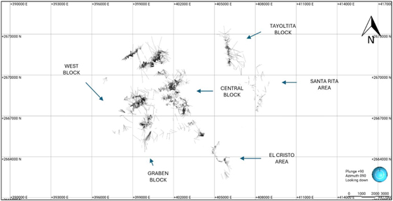
Figure 14-2: San Dimas Drill Hole Data Location, Plan View of Ventanas Mine Area
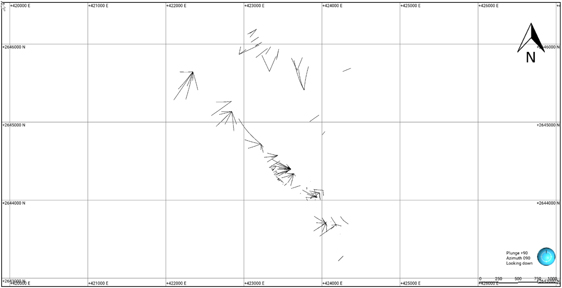
Note: Figure prepared by First Majestic, April 2025.
| 122 | September 2025 |
| San Dimas Silver/Gold Mine Durango and Sinaloa States, Mexico NI-43-101 Technical Report on Mineral Resource and Mineral Reserve Estimates |
|
| 14.2.2. | Geological Interpretation and Modeling |
The Mineral Resource estimates are constrained by the 3D geological interpretation and modelled domains of vein-hosted mineral deposits at San Dimas. The modelled vein domains are constructed from drill hole core logs, drill hole and production channel sample assay intervals, and contacts incorporated from underground geological maps produced by the mine geology staff. Three-dimensional geological modeling was completed for 35 veins using Leapfrog Geo. The domains also incorporated numerous faulted sub-domains that were identified in the underground mine. Each vein was modelled as a single estimation domain.
Figure 14-3 shows the location of the modelled domains, and an example of the geological modeling is shown for the Perez vein in Figure 14-4.
Figure 14-3: Plan-view Location of Estimation Domains by Mine Zone
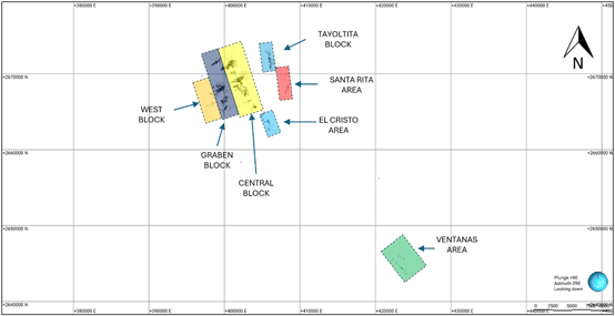
Note: Figure prepared by First Majestic, April 2025.
| 123 | September 2025 |
| San Dimas Silver/Gold Mine Durango and Sinaloa States, Mexico NI-43-101 Technical Report on Mineral Resource and Mineral Reserve Estimates |
|
Figure 14-4: Faulted Geological Model for the Perez Vein, Vertical and Plan Views
Note: The Mineral Resource domain for the quartz vein is shown in red. Drill hole intercepts and channel samples shown in colored dots. Figure prepared by First Majestic, April 2025.
The boundaries of the domain models strictly adhere to the contacts of the veins with the surrounding country rock to produce reasonable representations of the mineral deposit locations and volumes. The Mineral Resource domains also incorporate some faulted sub-domains that are identified by the underground mine development. Table 14-2 lists the nine resource domains and associated codes.
Table 14-2: San Dimas—West Block Domain Names and Mine Codes
| Area |
Vein | Domain Name | Domain Code | |||
| West Block |
Perez | Veta Perez | VPE | |||
| West Block |
Perez | Veta Perez2 | VPE2 | |||
| West Block |
Perez | Veta Perez3 | VPE3 | |||
| West Block |
Perez | Veta Perez4 | VPE4 | |||
| West Block |
Santa Teresa | Santa Teresa2 | VST2 | |||
| West Block |
Santa Teresa | Santa Teresa | VSTE | |||
| West Block |
Marshall | Marshall | Marshall | |||
| West Block |
Marshall | Rosario | VROS |
| 14.2.3. | Exploratory Sample Data Analysis |
Exploratory data analysis was completed for gold and silver sample assay values for each of the estimation domains to assess the statistical and spatial characteristics of the sample data. The sample data were examined in 3D to determine the spatial distribution of mineralized intervals and to look for possible mixed sample populations.
| 124 | September 2025 |
| San Dimas Silver/Gold Mine Durango and Sinaloa States, Mexico NI-43-101 Technical Report on Mineral Resource and Mineral Reserve Estimates |
|
| 14.2.4. | Boundary Analysis |
Boundary analysis was completed for each of the mineral resource domains to review the change in metal grade across the domain contacts using boundary plots. There is a sharp grade change across the contact and hard boundary conditions are observed in all domains. Hard boundaries were used during the construction of sample composite samples and during Mineral Resource estimation. Composite samples were restricted to their respective resource domain (Figure 14-5).
Figure 14-5: Example of Hard Boundary Contact Analysis for Silver for the Perez Vein.
Note: Figure prepared by First Majestic, April 2025.
| 14.2.5. | Compositing |
To select an appropriate composite sample length, the sample intervals were reviewed for each domain. The selected composite length varied by domain with the most common composite sample length being 1.0 m. The assay sample intervals were composited within the limits of the domain boundaries and then tagged with the appropriate domain code. Any short residual composite samples left at the end of the vein intersection were distributed evenly across the vein composite intervals. Composite sample length examples for the West Block area are detailed in Table 14-3. Figure 14-6 shows the sample interval lengths before and after compositing for the Perez vein.
| 125 | September 2025 |
| San Dimas Silver/Gold Mine Durango and Sinaloa States, Mexico NI-43-101 Technical Report on Mineral Resource and Mineral Reserve Estimates |
|
Table 14-3: West Block Composite Sample Lengths by Domain
| Area |
Vein | Domain | Composite Length (m) | Residual End Length Treatment | ||||
| West Block |
Perez | VPE | 0.8 | Add to previous interval | ||||
| West Block |
Perez | VPE2 | 0.8 | Add to previous interval | ||||
| West Block |
Perez | VPE3 | 0.8 | Add to previous interval | ||||
| West Block |
Perez | VPE4 | 0.8 | Add to previous interval | ||||
| West Block |
Santa Teresa | VST2 | 1.0 | Add to previous interval | ||||
| West Block |
Santa Teresa | VSTE | 1.0 | Add to previous interval | ||||
| West Block |
Marshall | Marshall | 0.6 | Add to previous interval | ||||
| West Block |
Rosario | VROS | 1.0 | Add to previous interval |
Figure 14-6: Sample Interval Lengths, Composited vs. Uncomposited, Perez Vein
Note: Figure prepared by First Majestic, April 2025.
| 14.2.6. | Evaluation of Composite Sample Outlier Values |
Drill hole and channel composite samples were evaluated for high-grade outliers and those outliers were capped to values considered appropriate for the estimation. Outlier values at the high end of the grade distributions were identified for both gold and silver from inflection points of cumulative probability plots and analysis of histogram plots. The spatial distribution of such outliers was also investigated. To quantify the impact of capping, the resource was evaluated to assess the change in metal content for the
| 126 | September 2025 |
| San Dimas Silver/Gold Mine Durango and Sinaloa States, Mexico NI-43-101 Technical Report on Mineral Resource and Mineral Reserve Estimates |
|
estimation due to capping. Figure 14-7 is an example of the global capping analysis performed to identify extreme outlier values.
Capping of assay values was limited to a select few extreme values. To reduce bias from a larger set of high-grade samples, those outlier values were range restricted. Samples above a specified high-grade threshold value were used at full value out to a specified distance from the sample. Beyond the specified distance the samples were reduced in value to a stated high-grade threshold value. Table 14-4 shows the percentage of the outlier values that were capped. Table 14-5 shows the impact of the capping on the metal content by domain.
Figure 14-7: Global Capping Analysis for Gold Composite Samples for the Perez Vein with capping at 5,785 g/t.
Note: Figure prepared by First Majestic, April 2025.
| 127 | September 2025 |
| San Dimas Silver/Gold Mine Durango and Sinaloa States, Mexico NI-43-101 Technical Report on Mineral Resource and Mineral Reserve Estimates |
|
Table 14-4: San Dimas Example—West Block, Composite Sample Capping by Domain
| Silver | Gold | |||||||||||||||||
| Area |
Vein | Domains | Number Composites |
Capping | Number Capped |
% Capped |
Capping | Number Capped |
% Capped |
|||||||||
| West Block |
Perez | VPE | 5,307 | 5,785 | 25 | 0.47% | 38 | 27 | 0.51% | |||||||||
| West Block |
Perez | VPE2 | 551 | 5,600 | 11 | 2.00% | 35 | 10 | 1.81% | |||||||||
| West Block |
Perez | VPE3 | 22 | NO | NO | NO | NO | NO | NO | |||||||||
| West Block |
Perez | VPE4 | 12 | NO | NO | NO | NO | NO | NO | |||||||||
| West Block |
SantaTeresa | VST2 | 29 | NO | NO | NO | NO | NO | NO | |||||||||
| West Block |
SantaTeresa | VSTE | 582 | 1,200 | 7 | 1.20% | 25 | 4 | 0.69% | |||||||||
| West Block |
Marshall | Marshall | 304 | 2,200 | 3 | 0.99% | 22 | 3 | 0.99% | |||||||||
| West Block |
Rosario | VROS | 106 | NO | NO | NO | NO | NO | NO | |||||||||
Table 14-5: San Dimas Example—West Block, Remaining Metal content by Domain after Capping
| Area |
Vein | Domains | Ag | Au | ||||
| t. oz | t. oz | |||||||
| West Block |
Perez | VPE | 95% | 95% | ||||
| West Block |
Perez | VPE2 | 90% | 92% | ||||
| West Block |
Perez | VPE3 | 100% | 100% | ||||
| West Block |
Perez | VPE4 | 100% | 100% | ||||
| West Block |
SantaTeresa | VST2 | 100% | 100% | ||||
| West Block |
SantaTeresa | VSTE | 94% | 95% | ||||
| West Block |
Marshall | Marshall | 98% | 97% | ||||
| West Block |
Rosario | VROS | 100% | 100% |
| 14.2.7. | Composite Sample Statistics |
To assess the statistical character of the composite samples within each of the domains, the data were declustered by a cell declustering method. The declustered mean grade for gold and silver composite samples for estimation domains in the West Block are presented in Box and Whisker plots as an example, Figure 14-8.
| 128 | September 2025 |
| San Dimas Silver/Gold Mine Durango and Sinaloa States, Mexico NI-43-101 Technical Report on Mineral Resource and Mineral Reserve Estimates |
|
Figure 14-8: Box and Whisker Plots for Gold and Silver declustered composite statistics for resource domains in the West Block
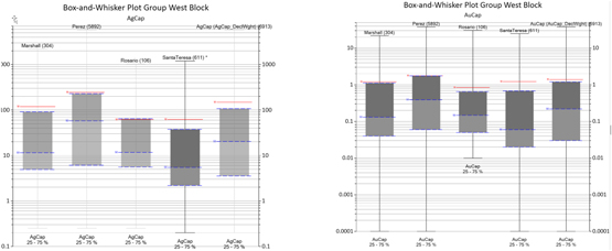
Note: Figure prepared by First Majestic, April 2025.
| 14.2.8. | Metal Trend and Spatial Analysis: Variography |
The dominant trends for gold and silver mineralization were identified based on the 3D numerical models for the metal in each domain. Model variograms for gold and silver composite values were developed along the trends identified, and the nugget values were established from downhole variograms. The variograms quantify and model the spatial continuity for the metals.
Figure 14-9 show the variogram plot and trend ellipsoid for the Perez vein.
| 129 | September 2025 |
| San Dimas Silver/Gold Mine Durango and Sinaloa States, Mexico NI-43-101 Technical Report on Mineral Resource and Mineral Reserve Estimates |
|
Figure 14-9: Variogram Model for the Perez Vein
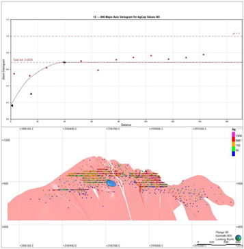
Note: Figure prepared by First Majestic, April 2025.
| 14.2.9. | Bulk Density |
An average bulk density of 2.6 t/m3 was used in estimation for all resource domains (refer to discussion in Section 10.9)
| 14.2.10. | Block Model Setup |
Block model estimates were prepared for each of the resource domains. The block models were rotated so that the x and y axes lie parallel to the domains, and the minimum-z direction is perpendicular to the trend of the domain. A sub-blocked model type was created that consists of primary parent blocks that are sub-divided into smaller sub-blocks whenever triggering surfaces intersect the parent blocks. The domain boundaries served as triggers. The size of the parent block considered the drill hole sample spacing and the mining methods. Block models typically used 10 m x 10 m x 1 m parent blocks (x, y, z) that were sub-blocked to 1 x 1 m x variable heights, with a minimum of 0.1 m (x, y, z). Gold and silver grades were estimated into the parent blocks.
| 130 | September 2025 |
| San Dimas Silver/Gold Mine Durango and Sinaloa States, Mexico NI-43-101 Technical Report on Mineral Resource and Mineral Reserve Estimates |
|
| 14.2.11. | Resource Estimation Procedure |
Block model estimates were completed for gold and silver. All block grades were estimated from composite samples captured within the respective domains. Following contact analysis, all domain contacts were treated as hard boundaries.
Block grades were estimated primarily by inverse distance weighting to the second power (ID2) and less commonly by ordinary kriging (OK). After inspection of the estimated gold and silver grades, many of the block models were judged to perform better with ID2 than with OK. The method selected in each case considered the characteristics of the domain, data spacing, variogram quality, and which method produced the best representation of grade continuity.
All channel samples that were used during construction of the geological models were reviewed. Only those channels that completely cross the deposit were used during grade estimation. Channel samples that cross only a portion of the deposit were excluded as non-representative samples.
The production channel sampling method has some risk of non-representative sampling that could produce local grade bias. However, the substantial number of samples collected and used in the estimation may compensate for this issue and provide accurate results. There remains a risk that the channel samples could suffer from a systematic sampling issue that could also result in poor accuracy. These risks are recognized and addressed during resource grade estimation by eliminating the undue influence of channel samples over drill hole samples for blocks estimated at longer distances. The grade estimation process was run in two or three successive passes whenever production channel samples were present. The first pass used all composites, including production channel samples, and only estimated blocks within a restricted short distance from the channel samples. Passes two or three applied less restrictive criteria using drill hole composites and sawn channel composites only.
An example of the gold–silver estimation parameters used for the Perez domain is included in
| 131 | September 2025 |
| San Dimas Silver/Gold Mine Durango and Sinaloa States, Mexico NI-43-101 Technical Report on Mineral Resource and Mineral Reserve Estimates |
|
Table 14-6: Summary of Ag-Au Estimation Parameters for the Perez Block Model
| Estimation Domain |
Perez | |||||||
| Pass |
Pass 1 | Pass 2 | ||||||
| Value Clipping Upper (g /t Ag) |
5785 | 5785 | ||||||
| Value Clipping Upper (g /t Au) |
38 | 38 | ||||||
| Search Ellipsoid Orientation |
||||||||
| Dip |
63 | 63 | ||||||
| Dip-Azimuth |
150 | 150 | ||||||
| Pitch |
21 | 21 | ||||||
| Search Ellipsoid Length (m) |
||||||||
| Maximum |
22 | 180 | ||||||
| Intermediate |
16 | 90 | ||||||
| Minimum |
12 | 60 | ||||||
| Minimum Samples |
11 | 6 | ||||||
| Maximum Samples |
24 | 22 | ||||||
Figure 14-10: Block Model Estimation Passes for the Perez Domain, Vertical Section
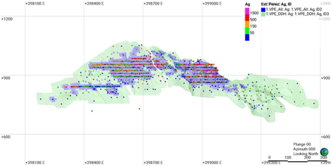
Note: Pass 1 = Blue, Pass 2 = Green. Figure prepared by First Majestic, April 2025.
| 14.2.12. | Block Model Validation |
Validation of the silver and gold grade estimations in the block models was completed for each of the resource estimation domains. The procedure was conducted as follows:
| • | Comparison of wireframe domain volumes to block model volumes for the domains; |
| • | Visual inspection comparing the composite sample silver and gold grades to the estimated block values; |
| 132 | September 2025 |
| San Dimas Silver/Gold Mine Durango and Sinaloa States, Mexico NI-43-101 Technical Report on Mineral Resource and Mineral Reserve Estimates |
|
| • | Comparison of the gold and silver grades in “well-informed” parental blocks to the average sample values of the composited samples contained within those blocks using scatter plots. |
| • | Comparison of the global mean declustered composite grades to the block model mean grade for each resource domain; |
| • | Comparison of local block grade trends to composited sample grades along the three block model axes (i.e., easting, northing, and elevation) with swath grade trend plots. |
| • | Reconciliation of estimated tonnes and gold and silver grades to compared to mine reported production on a monthly and 12 month rolling basis. |
The silver and gold estimated block grades were visually inspected in vertical sections. This review indicated that the supporting composite sample grades closely matched the estimated block values. Figure 14-11 and Figure 14-12 show the estimated block model silver and gold grades and the composite sample grades used in the estimation for the Perez vein.
Figure 14-11: Perez Ag g/t Block Model and Composite Sample Values, Vertical Section
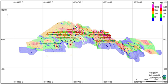
Note: Figure prepared by First Majestic, April 2025.
| 133 | September 2025 |
| San Dimas Silver/Gold Mine Durango and Sinaloa States, Mexico NI-43-101 Technical Report on Mineral Resource and Mineral Reserve Estimates |
|
Figure 14-12: Perez Au g/t Block Model and Composite Sample Values, Vertical Section
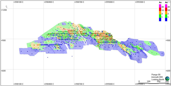
Note: Figure prepared by First Majestic, April 2025.
The block model estimates were validated by comparing the estimated block grades for gold and silver to nearest neighbor (NN) block estimates and to the composite sample values in swath plots oriented in three directions. The estimated block grades, NN grades, and composite sample grade trends are similar in all directions for all resource domains. Figure 14-13 to Figure 14-15 show swath plots for silver grades estimated by ID2, OK, and NN along the x, y and z axes for the Perez vein.
| 134 | September 2025 |
| San Dimas Silver/Gold Mine Durango and Sinaloa States, Mexico NI-43-101 Technical Report on Mineral Resource and Mineral Reserve Estimates |
|
Figure 14-13: Swath Plot in X across the Perez Vein, Ag Values
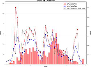
Note: Figure prepared by First Majestic, April 2025.
Figure 14-14: Swath Plot in Y across the Perez Vein, Ag Values
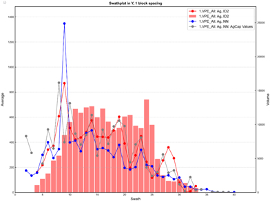
Note: Figure prepared by First Majestic, April 2025.
| 135 | September 2025 |
| San Dimas Silver/Gold Mine Durango and Sinaloa States, Mexico NI-43-101 Technical Report on Mineral Resource and Mineral Reserve Estimates |
|
Figure 14-15: Swath Plot in Z across the Perez Vein, Ag Values
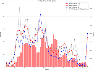
Note: Figure prepared by First Majestic, April 2025.
Overall, the validation demonstrates that the current Mineral Resource estimates are a reasonable representation of the input sample data.
Since the December 31, 2024, cut-off date for sample data used in the Mineral Resource estimates, additional drilling and production channel sampling from new mine developments has been completed and reviewed. This new data supports both the geological model and the Mineral Resource estimates. Overall, the validation supports that the current Mineral Resource estimates are a reasonable representation of the input sample data.
| 14.2.13. | Reconciliation |
A monthly evaluation is completed to compare the estimated tonnage and grades for gold and silver obtained from the block model estimates captured by the scans of the mine cavity monitoring system (CMS) to the mine reported production. The production reported is based on direct measurements of weighed truck tonnes and direct sampling of all material deposited at the plant patio stockpiles for each truck. Figure 14-16 compares the block model tonnes and grades captured inside the CMS to the monthly mine extraction recorded by the Mine Geology Department over 12 months of production for 2024. A good correlation is observed between the estimated silver and gold grades and the extracted grades over a 12-month period. As expected, there is short-term monthly variability but over 12 months the accumulated estimated grades compare closely to the grades determined by grade control.
| 136 | September 2025 |
| San Dimas Silver/Gold Mine Durango and Sinaloa States, Mexico NI-43-101 Technical Report on Mineral Resource and Mineral Reserve Estimates |
|
Figure 14-16: San Dimas Mine Block Model Ag and Au Estimates (yellow) compared to mine reported production (green) on a monthly basis over a 12-month period ending December 15, 2024
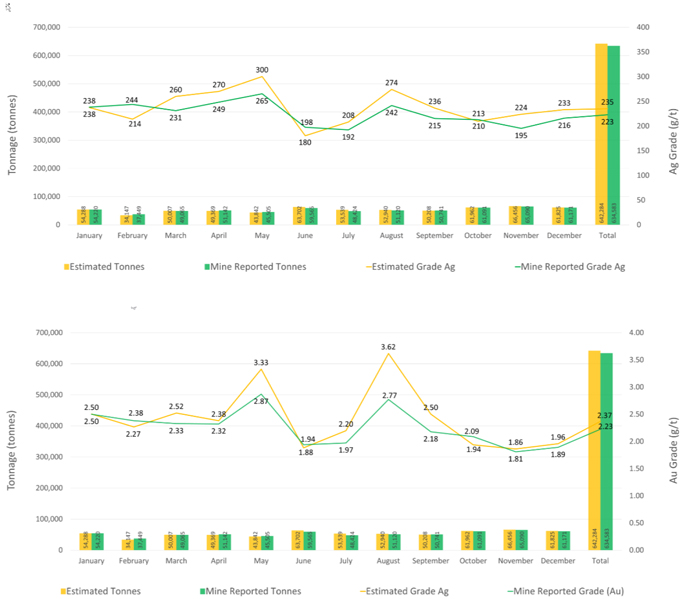
Note: Figure prepared by First Majestic, April 2025.
| 14.2.14. | Mineral Resource Classification |
Block model Mineral Resource estimates were classified according to the 2014 “CIM Definition Standards for Mineral Resources & Mineral Reserves” using industry best practices as outlined in the 2019 “CIM Estimation of Mineral Resources and Mineral Reserves Best Practice Guidelines”. Best practices in the industry advise that the classification of resources should consider the resource geologist’s confidence in the geological interpretation and model; confidence in the grade continuity for the mineralized domains; and the measure of sample support along with the quality of the sample data. Appropriate classification strategy integrates these concepts to delineate areas of similar confidence and risk.
| 137 | September 2025 |
| San Dimas Silver/Gold Mine Durango and Sinaloa States, Mexico NI-43-101 Technical Report on Mineral Resource and Mineral Reserve Estimates |
|
The Mineral Resource estimates were classified into Measured, Indicated, or Inferred categories and considered the following factors:
| • | Confidence in the geological interpretation and models; |
| • | Confidence in the continuity of metal grades; |
| • | The sample support for the estimation and reliability of the sample data; |
| • | Areas that were mined producing reliable production channel samples and detailed geological control. |
The method used to measure the sample support used for the Mineral Resource classification was the nominal drill hole spacing. The nominal drill hole spacing was produced by an estimation pass for each block in the model that used three composite samples with a maximum of one sample per drill hole, which requires three separate drill holes. The average distance for each block to the three closest drill holes was estimated, and then the nominal drill hole spacing was estimated by dividing the average distance to the drill holes by 0.7.
Blocks were flagged to consider for the Measured category if the nominal drill hole spacing was <15 m or the blocks were within 15 m of a mined development with production channel samples and geological control. Blocks were flagged to consider for the Indicated category if the nominal drill hole spacing was <35 m or the blocks were within 35 m of a mined development with production channel samples and geological control. Blocks were flagged to consider for the Inferred category if the nominal drill hole spacing was <60 m.
Wireframes were constructed to encompass block model zones for Measured, Indicated, and Inferred categories. This process allowed for review of the geological confidence for the deposit together with drill hole support and expanded certain areas but excluded others from the classification. Blocks were finally assigned to a classification category by the respective wireframe if the centroid of the block fell inside the wireframe.
Additional sample and underground mapping data collected since December 31, 2024, has been reviewed and supports the mineral resource classifications presented here. Figure 14-17 is an example of a projected vertical section (“long section”) displaying the Measured, Indicated, and Inferred Mineral Resource classification categories for the Perez vein.
| 138 | September 2025 |
| San Dimas Silver/Gold Mine Durango and Sinaloa States, Mexico NI-43-101 Technical Report on Mineral Resource and Mineral Reserve Estimates |
|
Figure 14-17: Measured, Indicated, and Inferred Mineral Resource Confidence Assignments, Perez Vein
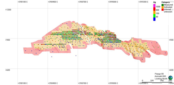
Note: Figure prepared by First Majestic, April 2025.
| 14.2.15. | Reasonable Prospects for Eventual Economic Extraction |
The Mineral Resource estimates were evaluated for reasonable prospects for eventual economic extraction (“RPEEE”) by application of input parameters based on mining and processing information from actual operations performance during 2022 and 2024. The economic parameters assumed for Mineral Resource estimates include operating costs, metallurgical recovery, metal prices and other parameters are shown in Table 14-7.
Table 14-7: Input Parameters for Evaluation of Reasonable Prospects of Eventual Economic Extraction.
| Concept |
Units | Values | ||
| Direct Mining Cost |
$/t | 64.73 | ||
| Direct Milling Cost |
$/t | 31.49 | ||
| Indirect and G&A Costs |
$/t | 65.51 | ||
| Sustaining Costs |
$/t | 12.69 | ||
| Metallurgical Recovery Ag |
% | 92.6 | ||
| Metallurgical Recovery Au |
% | 95.6 | ||
| Metal Payable Ag and Au |
% | 99.95 | ||
| Metal Price Ag |
$/oz Ag | 28 | ||
| Metal price Au |
$/oz Au | 2400 |
Underground longhole and cut-and-fill mining methods are assumed with minimum mining widths of 1.6 m and 1.2 m, respectively.
The Net Smelter Return (“NSR”) value was calculated from the input parameters and block model estimates and the cut-off value considered to constrain resources is $174/t. The NSR calculation assumed
| 139 | September 2025 |
| San Dimas Silver/Gold Mine Durango and Sinaloa States, Mexico NI-43-101 Technical Report on Mineral Resource and Mineral Reserve Estimates |
|
an underground operation and was based on the actual and budgeted operating and sustaining costs described above. NSR is described in detail in Section 15.2.
The Ag-Eq metal grades reported for the Mineral Resource estimates were calculated as follows:
| • | Ag-Eq g/t = Ag g/t + (Au g/t * Au Factor); |
| • | Au Factor = Au Revenue / Ag Revenue; |
| • | Au Revenue = (Au Metal Price / 31.1035) x Au Recovery x Au Payable; |
| • | Ag Revenue = (Ag Metal Price / 31.1035) x Ag Recovery x Ag Payable. |
Deswik Stope Optimizer software was used to identify the blocks that represent mineable volumes that exceed the cut-off value while complying with the aggregate of economic parameters. This tool allows blocks to be aggregated into the minimum stope dimensions and eliminate outliers that do not comply with these conditions. A second approach was also used following a methodology based on a set of calculations in the block model. The variables used were the true thickness from each vein, the minimum mining width, and the cut-off grade depending on the mining method. Results from this methodology were validated against the stope optimization in Deswik and were found to produce near identical results.
| 14.2.16. | Mining Depletion |
Models of the underground mining excavations were evaluated into the block models for all domains. These modeled volumes were used to deplete the block model Mineral Resource estimates prior to reporting the resources. Regions within the mine such as unmined pillars that are in situ but judged to be un-mineable were also removed from the estimates.
| 14.3. | Statement of Mineral Resource Estimates |
The Mineral Resources estimated for San Dimas are reported assuming underground mining methods, and an NSR cut-off value of $174/t. All Mineral Resources are reported using the 2014 CIM Definition Standards with an effective date of December 31, 2024.
The consolidated Measured and Indicated Mineral Resource Estimates are provided in Table 14-8, and Inferred Mineral Resource estimates are included in Table 14-9. Measured and Indicated Mineral Resource Estimates are reported inclusive of Mineral Reserve estimates. Mineral Resource estimates that are not Mineral Reserve estimates do not have demonstrated economic viability.
| 140 | September 2025 |
| San Dimas Silver/Gold Mine Durango and Sinaloa States, Mexico NI-43-101 Technical Report on Mineral Resource and Mineral Reserve Estimates |
|
Table 14-8: San Dimas Measured and Indicated Mineral Resource Estimate
(effective date December 31, 2024)
| Category / Area |
Mineral Type | Tonnage | Grades | Metal Content | ||||||||||||||||||||||||||
| k tonnes | Ag (g/t) | Au (g/t) | Ag-Eq (g/t) | Ag (k Oz) | Au (k Oz) | Ag-Eq (k Oz) | ||||||||||||||||||||||||
| Measured Central Block |
Sulphides | 1,169 | 355 | 4.79 | 778 | 13,320 | 180 | 29,240 | ||||||||||||||||||||||
| Measured Sinaloa Graben |
Sulphides | 478 | 360 | 4.84 | 789 | 5,540 | 74 | 12,120 | ||||||||||||||||||||||
| Measured Other Areas |
Sulphides | 205 | 399 | 3.80 | 735 | 2,630 | 25 | 4,850 | ||||||||||||||||||||||
|
|
|
|
|
|
|
|
|
|
|
|
|
|
|
|
||||||||||||||||
| Total Measured |
Sulphides | 1,851 | 361 | 4.69 | 776 | 21,490 | 279 | 46,210 | ||||||||||||||||||||||
|
|
|
|
|
|
|
|
|
|
|
|
|
|
|
|
||||||||||||||||
| Indicated Central Block |
Sulphides | 1,326 | 248 | 2.79 | 494 | 10,550 | 119 | 21,070 | ||||||||||||||||||||||
| Indicated Sinaloa Graben |
Sulphides | 543 | 245 | 3.07 | 517 | 4,280 | 54 | 9,030 | ||||||||||||||||||||||
| Indicated Tayoltita |
Sulphides | 158 | 326 | 4.04 | 684 | 1,660 | 21 | 3,480 | ||||||||||||||||||||||
| Indicated Other Areas |
Sulphides | 997 | 335 | 3.00 | 600 | 10,730 | 96 | 19,240 | ||||||||||||||||||||||
|
|
|
|
|
|
|
|
|
|
|
|
|
|
|
|
||||||||||||||||
| Total Indicated |
Sulphides | 3,025 | 280 | 2.97 | 543 | 27,220 | 289 | 52,820 | ||||||||||||||||||||||
|
|
|
|
|
|
|
|
|
|
|
|
|
|
|
|
||||||||||||||||
| M+I Central Block |
Sulphides | 2,494 | 298 | 3.72 | 627 | 23,870 | 299 | 50,300 | ||||||||||||||||||||||
| M+I Sinaloa Graben |
Sulphides | 1,021 | 299 | 3.90 | 645 | 9,820 | 128 | 21,160 | ||||||||||||||||||||||
| M+I Tayoltita |
Sulphides | 158 | 326 | 4.04 | 684 | 1,660 | 21 | 3,480 | ||||||||||||||||||||||
| M+I Other Areas |
Sulphides | 1,202 | 346 | 3.14 | 623 | 13,360 | 121 | 24,080 | ||||||||||||||||||||||
|
|
|
|
|
|
|
|
|
|
|
|
|
|
|
|
||||||||||||||||
| Total M+I |
Sulphides | 4,876 | 311 | 3.63 | 632 | 48,710 | 569 | 99,020 | ||||||||||||||||||||||
|
|
|
|
|
|
|
|
|
|
|
|
|
|
|
|
||||||||||||||||
Table 14-9: San Dimas Inferred Mineral Resource Estimate
(effective date December 31, 2024)
| Category / Area |
Mineral Type | Tonnage | Grades | Metal Content | ||||||||||||||||||||||||||
| k tonnes | Ag (g/t) | Au (g/t) | Ag-Eq (g/t) | Ag (k Oz) | Au (k Oz) | Ag-Eq (k Oz) | ||||||||||||||||||||||||
| Inferred Central Block |
Sulphides | 1,897 | 251 | 3.02 | 518 | 15,330 | 184 | 31,610 | ||||||||||||||||||||||
| Inferred Sinaloa Graben |
Sulphides | 526 | 382 | 5.20 | 842 | 6,470 | 88 | 14,260 | ||||||||||||||||||||||
| Inferred Tayoltita |
Sulphides | 506 | 261 | 3.10 | 536 | 4,250 | 50 | 8,710 | ||||||||||||||||||||||
| Inferred Other Areas |
Sulphides | 2,400 | 217 | 2.24 | 415 | 16,760 | 173 | 32,050 | ||||||||||||||||||||||
|
|
|
|
|
|
|
|
|
|
|
|
|
|
|
|
||||||||||||||||
| Total Inferred |
Sulphides | 5,329 | 250 | 2.89 | 506 | 42,810 | 495 | 86,630 | ||||||||||||||||||||||
|
|
|
|
|
|
|
|
|
|
|
|
|
|
|
|
||||||||||||||||
| (1) | Mineral Resource estimates are classified per CIM Definition Standards (2014) and NI 43-101. |
| (2) | Mineral Resource estimates are based on internal estimates with an effective date of December 31, 2024. |
| (3) | Mineral Resource estimates were supervised or reviewed by David Rowe, CPG, Internal Qualified Person for First Majestic, per NI 43-101. |
| (4) | Silver-equivalent grade (Ag-Eq) is calculated as follows: |
Ag-Eq = Ag Grade + (Au Grade x Au Recovery x Au Payable x Au Price) / (Ag Recovery x Ag Payable x Ag Price).
| (5) | Metal prices for Mineral Resources estimates were $28.0/oz Ag and $2,400/oz Au. Metallurgical recovery used was 92.6% for silver and 95.6% for gold. Metal payable used was 99.95% for silver and gold. |
| (6) | NSR cutoff value considered to constrain resources assumed an underground operation was $174/t and was based on actual and budgeted operating and sustaining costs. |
| (7) | Mineral Resources are reported within mineable stope shapes using the NSR cutoff value calculated using the stated metal prices and metal recoveries. The NSR cutoff includes mill recoveries and payable metal factors appropriate to the existing processing circuit. |
| (8) | No dilution was applied to the Mineral Resource which are reported on an in-situ basis. |
| (9) | Tonnage is expressed in thousands of tonnes; metal content is expressed in thousands of ounces. Totals may not add up due to rounding. |
| 141 | September 2025 |
| San Dimas Silver/Gold Mine Durango and Sinaloa States, Mexico NI-43-101 Technical Report on Mineral Resource and Mineral Reserve Estimates |
|
| (10) | Measured and Indicated Mineral Resources are reported inclusive of Mineral Reserves. Mineral Resources that are not Mineral Reserves do not have demonstrated economic viability. |
| 14.4. | Factors that May Affect the Mineral Resource Estimate |
Factors that may materially impact the Mineral Resource Estimates include:
| • | Changes to the assumptions used to generate the silver-equivalent grade cut-off grade including metal price, metallurgical recovery, cost assumption and exchange rates. |
| • | Changes to interpretations of mineralization geometry and continuity. |
| • | Changes to geotechnical, and mining method assumptions. |
| • | Assumptions as to the continued ability to access the site, retain mineral and surface rights titles, maintain environment and other regulatory permits, and maintain the social license to operate. |
| • | The production channel sampling method has some risk of non-representative sampling that could result in poor accuracy locally. In addition, there is potential for the substantial number of channel samples to overwhelm samples from the drill holes in some areas. This is recognized and addressed during resource estimation by restricting the area of influence related to these samples to short ranges. |
| 14.5. | Comments on Section 14 |
The QP for First Majestic is of the opinion that the Mineral Resource Estimates for San Dimas were estimated according to industry best practices and conform to the 2014 CIM Definition Standards for Mineral Resources. In the opinion of First Majestic, the Mineral Resource estimates reported here are a reasonable representation of the mineral resources found on the property at the current level of sampling.
| 142 | September 2025 |
| San Dimas Silver/Gold Mine Durango and Sinaloa States, Mexico NI-43-101 Technical Report on Mineral Resource and Mineral Reserve Estimates |
|
| 15. | MINERAL RESERVES ESTIMATES |
This section summarizes the methods, assumptions, parameters, and modifying factors used by First Majestic in the preparation of the Mineral Reserve estimates for San Dimas.
The mine design and scheduling work supporting the compilation of the Mineral Reserve estimates discussed herein was prepared under the supervision of Mr. Andrew Pocock, P.Eng. and the QP responsible for these estimates.
| 15.1. | Methodology |
The Mineral Reserve estimation process consists of converting Measured and Indicated Mineral Resource estimates to Proven and Probable Mineral Reserve Estimates by identifying material that exceeds the mining cut-off grades while conforming to specified geometrical constraints determined by the applicable mining method and by applying modifying factors such as mining dilution and mining recovery. If the Measured and Indicated Mineral Resource estimates comply with the previous constraints, Measured Resource estimates could be converted to Proven Mineral Reserve estimates and Indicated Mineral Resource estimates could be converted to Probable Mineral Reserve estimates, in some instances Measured Mineral Resource estimates could be converted to Probable Mineral Reserve estimates if any or more of the modifying factors reduced the confidence of the estimates.
The conversion of Measured and Indicated Mineral Resource estimates to Proven and Probable Mineral Reserve estimates involves the following procedures:
| • | Selection of a viable mining method for each of the geological domains, considering geometry of the deposit, geotechnical and geohydrological conditions, and metal grade distribution as observed during the examination of the block model and other mine design criteria. |
| • | Review of metal price assumptions approved by First Majestic’s management for Mineral Resource and Mineral Reserve estimates to be considered reasonable and following the “2020 CIM Guidance on Commodity Pricing and Other Issues related to Mineral Resource and Mineral Reserve Estimation and Reporting”. |
| • | Calculate net smelter return (NSR) and cut-off values (COVs), based on the assumed metal price guidance, assumed cost data, metallurgical recoveries, and smelting and refining terms as per the selling contracts. |
| • | Prepare the block models by adding the net smelter return (NSR), which is used in the stope optimization, and ensuring Inferred Mineral Resources will not be considered in the Mineral Reserve estimation process. |
| • | Compile relevant mine design parameters such as stope dimensions, minimum mining widths and pillar dimensions. |
| 143 | September 2025 |
| San Dimas Silver/Gold Mine Durango and Sinaloa States, Mexico NI-43-101 Technical Report on Mineral Resource and Mineral Reserve Estimates |
|
| • | Compile modifying factors such as dilution from blasting overbreak and geotechnical conditions and from mining loss while considering benchmarking from actual surveys, industry standard and underground observations. |
| • | Outline potentially mineable shapes from the block model based on Measured and Indicated Mineral Resource estimates that exceed the COV. |
| • | Screen potentially mineable shapes using stope optimization mining software to account for vein widths, minimum mining widths, dilution assumptions and economic factors. |
| • | Refine potentially mineable shapes by removing permanent sill and rib pillars, and by removing areas identified as inaccessible or unmineable due to geotechnical or stability conditions. |
| • | Design mine development and mine infrastructure required to access the potentially mineable shapes. |
| • | Carry out an economic analysis for groups of mineable shapes, such as sublevels or contiguous groups of shapes, and remove areas that are isolated from contiguous mining areas that will not cover the cost of development to reach those areas. |
| • | Set the mining sequence and define the production rates for each relevant area to produce the production schedule. |
| • | Estimate capital and operating costs required to extract this material and produce saleable product. |
| • | Estimate expected revenue after discounting selling costs. |
| • | Validate the economic viability of the overall plan with a discounted cash flow model. |
Once these steps are completed and a positive cash flow is demonstrated, the statement of Mineral Reserve Estimates can be prepared.
The common mining methods used in San Dimas are sublevel longhole stoping (longhole) and cut-and-fill. The method assigned to a vein or section depends on vein characteristics and attitude (i.e., width, dip, and rock competence, among others). The current tonnage contribution by mining method at San Dimas is 70% longhole and 15% cut-and-fill, with the remaining 15% coming from development in ore.
| 15.2. | Net Smelter Return |
The Net Smelter Return was calculated to determine the value for each block in the model based on the recoverable metal content and expected revenue, after deducting the relevant processing, transportation, and refining costs. The NSR was used as to assess if the revenue exceeds the operating and capital costs for blocks categorized as Measured or Indicated Mineral Resources. The NSR is calculated by using the after-refining value for each block of mined material and multiplying it by the grade in the block model and the NSR value is coded into the block model using Deswik production software.
NSR = Value of doré – (refining + transportation + insurance)
The NSR formulas was calculated from the assumed economic parameters shown in Table 15-1.
| 144 | September 2025 |
| San Dimas Silver/Gold Mine Durango and Sinaloa States, Mexico NI-43-101 Technical Report on Mineral Resource and Mineral Reserve Estimates |
|
Table 15-1: Economic Parameters Assumed for Calculation of NSR
| Concept |
Units | Values | ||||
| Metal Price Ag |
$/oz Ag | 26.00 | ||||
| Metal Price Au |
$/oz Au | 2,200 | ||||
| Metallurgical Recovery Ag |
% | 92.62 | % | |||
| Metallurgical Recovery Au |
% | 95.60 | % | |||
| Metal Patable Ag and Au |
% | 99.95 | % | |||
| Dore Transport Cost |
$/oz Dore | 0.047 | ||||
| Insurance and Representation Cost |
$/oz Dore | 0.046 | ||||
| Refining Charge Ag |
$/oz Ag | 0.225 | ||||
| Refining Charge Au |
$/oz Au | 0.500 | ||||
The cut-off value was calculated for the mine based on the parameters summarized in Table 15-2 and
| 145 | September 2025 |
| San Dimas Silver/Gold Mine Durango and Sinaloa States, Mexico NI-43-101 Technical Report on Mineral Resource and Mineral Reserve Estimates |
|
Table 15-3, which correspond to the operating and sustaining costs observed in San Dimas during the last 18 months of 2023-2024, and the 2025 budgeted costs. Cost allocation was applied using full costs (general), incremental costs (incremental), and marginal costs (marginal). General cost applies to mineralized material with sufficient value to fully support its on-site production costs. Incremental applies to mineralized material with values below the general cost that can still be included in the mineral reserve if certain costs to mine and process can assume to be zero. Marginal costs are applied to material that has to be mined to reach the general cut off material and only variable costs are applied. The methodology for estimating NSR cut off value aligns with the 2024 Mineral Reserve estimate and is consistent with the practice of other mines.
Table 15-2: Initial NSR Cut-Off Value Applied to Longhole
| Operating Costs - Longhole |
Full Cost |
Incremental Cost |
Marginal Cost |
|||||||||||||
| Mining (excluding haulage to plant) |
$ | / t | 61.91 | 55.72 | ||||||||||||
| Haulage to plant |
$ | / t | 9.01 | 9.01 | 9.01 | |||||||||||
| Milling |
$ | / t | 39.37 | 31.49 | 31.49 | |||||||||||
| Indirect |
$ | / t | 63.28 | 63.28 | 31.64 | |||||||||||
| G&A (site) |
$ | / t | 2.23 | 2.23 | ||||||||||||
| Sustaining plant and infrastructure |
$ | / t | 5.03 | 5.03 | ||||||||||||
| Sustaining mine PPE |
$ | / t | 7.66 | 7.66 | ||||||||||||
| Sustaining Development |
$ | / t | 21.27 | |||||||||||||
| Infill exploration and mining rights |
$ | / t | 0.14 | |||||||||||||
| Closure Cost Allocation |
$ | / t | 1.79 | |||||||||||||
| Total |
$ | / t | 211.69 | 174.42 | 72.14 | |||||||||||
| Cut-off Value |
General | Incremental | Marginal | |||||||||||||
| ROM all veins* |
$ | / t | 212 | 174 | 72 | |||||||||||
| 146 | September 2025 |
| San Dimas Silver/Gold Mine Durango and Sinaloa States, Mexico NI-43-101 Technical Report on Mineral Resource and Mineral Reserve Estimates |
|
Table 15-3: Initial NSR Cut-Off Value Applied to Cut-and-Fill
| Operating costs cut-and-fill |
Full Cost |
Incremental Cost |
Marginal Cost |
|||||||||||||
| Mining (excluding haulage to plant) |
$ | / t | 96.55 | 86.9 | ||||||||||||
| Haulage to plant |
$ | / t | 8.8 | 8.8 | 8.8 | |||||||||||
| Milling |
$ | / t | 39.37 | 31.49 | 31.49 | |||||||||||
| Indirect |
$ | / t | 63.28 | 63.28 | 31.64 | |||||||||||
| G&A (site) |
$ | / t | 2.23 | 2.23 | ||||||||||||
| Sustaining plant and infrastructure |
$ | / t | 5.03 | 5.03 | ||||||||||||
| Sustaining Mine PPE |
$ | / t | 7.66 | 7.66 | ||||||||||||
| Sustaining Development |
$ | / t | 21.27 | |||||||||||||
| Infill exploration and mining rights |
$ | / t | 0.14 | |||||||||||||
| Closure Cost Allocation |
1.79 | |||||||||||||||
| Total |
$ | / t | 246.12 | 205.39 | 71.93 | |||||||||||
| Cut-off Value |
General | Incremental | Marginal | |||||||||||||
| ROM all veins* |
$ | / t | 246 | 205 | 72 | |||||||||||
Three cut-off values have been determined for San Dimas: general COV, incremental COV, and marginal COV.
| 15.3. | Block Model Preparation |
The mine planning software used to identify potentially mineable shapes is Deswik, which is used to discretize the mineralized structures by dividing the vein wireframes into 3.5 m-high by 3.5 m-long blocks, and 15m high by 4m long blocks for longhole mining. The diluted grade and tonnage, among other physical characteristics, are also assigned to these blocks from the mineral resource block model. An example of MSO outputs can be seen in Figure 15-1.
| 147 | September 2025 |
| San Dimas Silver/Gold Mine Durango and Sinaloa States, Mexico NI-43-101 Technical Report on Mineral Resource and Mineral Reserve Estimates |
|
Figure 15-1: MSO Mineable Shapes for the Perez Vein
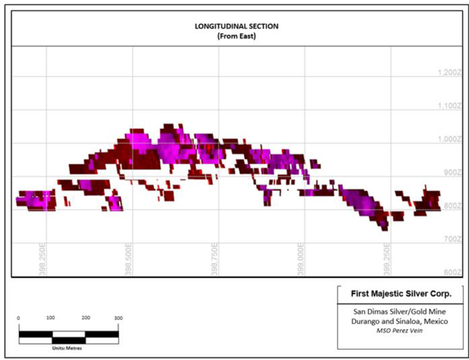
Note: Figure prepared by First Majestic, April 2025.
Next, the modifying mining factors were introduced into the model, which are used to estimate diluted grades based on the selected mining method, vein thickness, minimum mining width and external dilution assumptions. The mining loss factor is also incorporated into the model based on the assumed mining method.
| 15.4. | Dilution |
Modifying mining factors are the combination of dilution and mining loss that affect the quality and quantity of the material extracted during a mining operation. Dilution is waste material that enters the material movement stream and often has two negative impacts:
| • | Increased cost (mining, processing, treatment and increasing the storage of tailings); |
| • | Increased mineralized material loss (through increased processing costs and impacting on metallurgical recoveries). |
| 148 | September 2025 |
| San Dimas Silver/Gold Mine Durango and Sinaloa States, Mexico NI-43-101 Technical Report on Mineral Resource and Mineral Reserve Estimates |
|
There are multiple sources of dilution, and these can be classified in the following two categories: planned and unplanned dilution.
Planned dilution is additional waste that is deliberately mined concurrently with the target mineralised material, allowing the mineralised material to be fully recovered, leading to an overall lower mined grade. Many operations undergo an economic trade-off between selective, less productive methods and less selective, more productive methods, to determine if reducing the waste entering the ore stream results in better economic outcomes.
The planned dilution assumes a minimum mining width, which will depend on the applied mining method. The minimum mining width for cut-and-fill using jackleg drills was 0.8 m, while when using jumbo drills was 2.5 m. In the case of longhole mining, the minimum mining width assumed was 1.2 m.
The estimated overbreak in each side of the designed stope is 0.2 m for the two mining methods, longhole and cut-and-fill. An extra dilution from the backfill floor of 0.3 m for longhole and 0.2 m for cut-and-fill is also assumed
Unplanned dilution is waste material that unintentionally finds its way into the ore stream during the course of extraction and can be from a variety of sources including:
| • | Over-break during mining; |
| • | Mucking of waste material (or backfill or road base material) during the mucking of mineralised material; |
| • | Misrouting and dumping of waste material on the ore stockpile (ROM); |
| • | Misrouting and dumping of waste in ore locations (stockpiles, ore passes) leading to a mixing of mineralised material and waste rock; and, |
| • | Backfill dilution from adjacent stopes. |
Unplanned dilution is represented as a percentage of the undiluted stope. Figure 15-2 shows illustrations of the dilution assessment approach for each type of vein width and equipment used.
| 149 | September 2025 |
| San Dimas Silver/Gold Mine Durango and Sinaloa States, Mexico NI-43-101 Technical Report on Mineral Resource and Mineral Reserve Estimates |
|
Figure 15-2: Schematic Example of Dilution
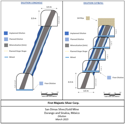
Note: Figure prepared by Entech Mining Consultants Ltd. for First Majestic.
| 15.5. | Mining Loss |
Mining loss refers to the percentage of mineralized material within the mine designs that will not be recovered into plant feed for various operational reasons.
Mining loss can have a significant impact on the mining business, with a reduction of revenue through the loss of mineralised material. Mining loss can occur in a variety of ways such as, poor blasting techniques, blast drillhole deviation, poor stope recovery, and weak ground conditions impacting on the access to the mineralised material. Mining loss occurs in most mining operations and an allowance for a reduction in revenue is prudent for budgeting and assessing for profitability. Mining loss is expressed as a percentage of diluted stope material.
An example of dilution and mining loss via underbreak (poor blasting practices) is illustrated below in Figure 15-3 and Figure 15-4. Note that underbreak in waste is an economic benefit, however it reflects that the operation is not achieving the targeted mining shape.
| 150 | September 2025 |
| San Dimas Silver/Gold Mine Durango and Sinaloa States, Mexico NI-43-101 Technical Report on Mineral Resource and Mineral Reserve Estimates |
|
Figure 15-3: Dilution and Mining Loss (longhole mining methods)
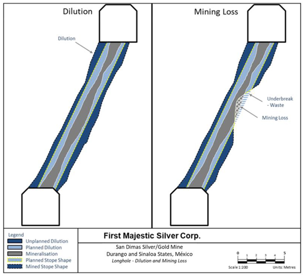
Note: Figure prepared by Entech Mining Consultants Ltd. for First Majestic.
| 151 | September 2025 |
| San Dimas Silver/Gold Mine Durango and Sinaloa States, Mexico NI-43-101 Technical Report on Mineral Resource and Mineral Reserve Estimates |
|
Figure 15-4: Dilution and Ore Loss (cut-and-fill mining method)
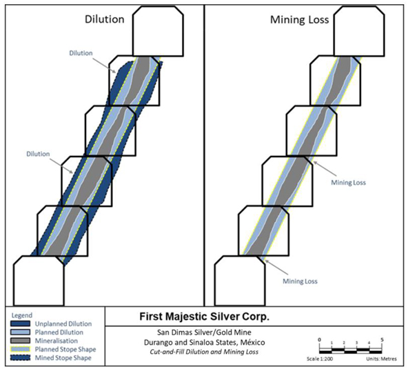
Note: Figure prepared by Entech Mining Consultants Ltd. for First Majestic.
Other than for sill mining, the average mining loss throughout each mining block for both cut-and-fill and longhole mining was assumed to be 5%. Sill pillars are designed as 3 m between production horizons, and crown pillars of 20 m is used for stopes near the surface. Areas of higher topography risk or historical mining areas are given heightened scrutiny and have been assigned a mining loss of 50% or 30% depending on the assessed risk. Table 15-4 shows the dilution and mining loss parameters assumed in this Technical Report.
| 152 | September 2025 |
| San Dimas Silver/Gold Mine Durango and Sinaloa States, Mexico NI-43-101 Technical Report on Mineral Resource and Mineral Reserve Estimates |
|
Table 15-4: Dilution and Mining Loss Parameters
| Mine |
Mining Method |
Mining Loss | Mineable Width |
Overbreak | Floor Dilution | |||||||||||||
| All mines |
Longhole | 5 | % | 1.2 m | 0.4 m | 0.2 m | ||||||||||||
| Cut-and-fill jumbo | 5 | % | 3.5 m | 0.2 m | 0.2 m | |||||||||||||
| Cut-and-fill jackleg | 5 | % | 0.8 m | 0.2 m | 0.3 m | |||||||||||||
| 15.6. | Mineral Reserve Estimates |
To convert from Measured and Indicated Mineral Resource estimates to Proven and Probable Mineral Reserve estimates, the resource blocks were interrogated by applying economic criteria as well as geometric constraints based on the mining method envisioned. Mineable blocks or stopes were defined by following this process.
The Net Smelter Return cut-off value was used as the main economic constraint and was derived from an NSR model prepared with the parameters described earlier. The silver and gold grades were also expressed in terms of Ag-Eq.
Deswik software was used to interrogate each vein. Stope shapes were only considered if the grade of the shape met or exceeded the general COV as a first pass to define new extraction levels, followed by the corresponding incremental COV for each vein and mining method assumed to identify contiguous material that could be extracted with the same infrastructure assumed for the material screened by the general COV. Once the development infrastructure was designed, a review was carried out to identify the blocks that must be mined to access the mineable shapes. If the material was above the marginal COV then these blocks were also included into the Mineral Reserve estimates.
Blocks below the general COV were included in the Mineral Reserve estimates as long as they fulfilled the criteria to be classified under the incremental and marginal COVs. Mineral Reserve blocks above the cut-off value are excluded when the blocks appear to be isolated or do not pass other economic considerations.
| 15.7. | Statement of Mineral Reserve Estimates |
The Mineral Reserves are tabulated in Table 15-5, and have an effective date of December 31, 2024. The QP for the estimate is Mr. Andrew Pocock, P.Eng.
| 153 | September 2025 |
| San Dimas Silver/Gold Mine Durango and Sinaloa States, Mexico NI-43-101 Technical Report on Mineral Resource and Mineral Reserve Estimates |
|
Table 15-5: San Dimas Proven and Probable Mineral Reserve Estimates (effective date December 31, 2024)
| Category / Area |
Mineral Type | Tonnage | Grades | Metal Content | ||||||||||||||||||||||||||||
| k tonnes | Ag (g/t) | Au (g/t) | Ag-Eq (g/t) | Ag (k Oz) | Au (k Oz) | Ag-Eq (k Oz) |
||||||||||||||||||||||||||
| Proven Central Block |
Sulphides | 780 | 255 | 3.47 | 557 | 6,390 | 87 | 13,980 | ||||||||||||||||||||||||
| Proven Sinaloa Graben |
Sulphides | 293 | 222 | 2.67 | 455 | 2,090 | 25 | 4,290 | ||||||||||||||||||||||||
| Proven Tayoltita |
Sulphides | 0 | 0 | 0.00 | 0 | 0 | 0 | 0 | ||||||||||||||||||||||||
| Proven Other Areas |
Sulphides | 184 | 297 | 2.65 | 528 | 1,750 | 16 | 3,120 | ||||||||||||||||||||||||
|
|
|
|
|
|
|
|
|
|
|
|
|
|
|
|
|
|||||||||||||||||
| Total Proven |
Sulphides | 1,257 | 253 | 3.16 | 529 | 10,230 | 128 | 21,390 | ||||||||||||||||||||||||
|
|
|
|
|
|
|
|
|
|
|
|
|
|
|
|
|
|||||||||||||||||
| Probable Central Block |
Sulphides | 732 | 228 | 2.74 | 467 | 5,370 | 65 | 11,010 | ||||||||||||||||||||||||
| Probable Sinaloa Graben |
Sulphides | 381 | 211 | 2.66 | 443 | 2,580 | 33 | 5,430 | ||||||||||||||||||||||||
| Probable Tayoltita |
Sulphides | 133 | 206 | 2.74 | 445 | 880 | 12 | 1,900 | ||||||||||||||||||||||||
| Probable Other Areas |
Sulphides | 726 | 275 | 2.48 | 492 | 6,420 | 58 | 11,470 | ||||||||||||||||||||||||
|
|
|
|
|
|
|
|
|
|
|
|
|
|
|
|
|
|||||||||||||||||
| Total Probable |
Sulphides | 1,972 | 241 | 2.63 | 470 | 15,250 | 167 | 29,810 | ||||||||||||||||||||||||
|
|
|
|
|
|
|
|
|
|
|
|
|
|
|
|
|
|||||||||||||||||
| P+P Central Block |
Sulphides | 1,512 | 242 | 3.11 | 514 | 11,760 | 151 | 24,990 | ||||||||||||||||||||||||
| P+P Sinaloa Graben |
Sulphides | 674 | 216 | 2.67 | 448 | 4,670 | 58 | 9,720 | ||||||||||||||||||||||||
| P+P Tayoltita |
Sulphides | 133 | 206 | 2.74 | 445 | 880 | 12 | 1,900 | ||||||||||||||||||||||||
| P+P Other Areas |
Sulphides | 910 | 279 | 2.51 | 499 | 8,170 | 74 | 14,590 | ||||||||||||||||||||||||
|
|
|
|
|
|
|
|
|
|
|
|
|
|
|
|
|
|||||||||||||||||
| Total P+P |
Sulphides | 3,229 | 245 | 2.84 | 493 | 25,480 | 294 | 51,200 | ||||||||||||||||||||||||
|
|
|
|
|
|
|
|
|
|
|
|
|
|
|
|
|
|||||||||||||||||
| (1) | Mineral Reserves are classified per CIM Definition Standards (2014) and NI 43-101. |
| (2) | Mineral Reserves are effective December 31, 2024, are derived from Measured & Indicated Resources, account for depletion to that date, and are reported with a reference point of mined ore delivered to the plant. |
| (3) | Mineral Reserve estimates were supervised or reviewed by Andrew Pocock, P.Eng., Internal Qualified Person for First Majestic per NI 43-101. |
| (4) | Silver-equivalent grade (Ag-Eq) is calculated as follows: |
Ag-Eq Grade = Ag Grade + Au Grade *( Au Recovery * Au Payable * Au Price) / (Ag Recovery * Ag Payable * Ag Price)
| (5) | Metal prices for Reserves: $26/oz Ag, $2,200/oz Au. Other key assumptions and parameters include Metallurgical recoveries of 92.6% Ag, 95.6% Au; metal payable of 99.95% Ag & Au, costs ($/t): direct mining $61.91 longhole stoping and $96.55 cut & fill, processing $39.37 mill feed, indirect/G&A $65.51 and sustaining $35.88 for longhole stoping and cut & fill. |
| (6) | A two-step cutoff approach was used per mining method: A general cutoff value defines mining areas covering all associated costs; and a 2nd pass incremental cutoff value includes adjacent material covering only its own costs, excluding shared general development access & infrastructure costs which are covered by the general cutoff value material. |
| (7) | Modifying factors for conversion of resources to reserves include but are not limited to consideration for mining methods, mining recovery, dilution, sterilization, depletion, cutoff grades, geotechnical conditions, metallurgical factors, infrastructure, operability, safety, environmental, regulatory, social, and legal factors. These factors were applied to produce mineable stope shapes. |
| (8) | Tonnage in thousands of tonnes, metal content in thousands of ounces, prices/costs in USD. Numbers are rounded per guidelines; totals may not sum due to rounding. |
| 154 | September 2025 |
| San Dimas Silver/Gold Mine Durango and Sinaloa States, Mexico NI-43-101 Technical Report on Mineral Resource and Mineral Reserve Estimates |
|
| 15.8. | Factors that May Affect the Mineral Reserve Estimates |
Factors that could affect the Mineral Reserves estimate include changes to the following assumptions:
| • | Metal prices and exchange rates; |
| • | Unplanned dilution; |
| • | Mining recovery; |
| • | Geotechnical conditions; |
| • | Equipment productivities; |
| • | Metallurgical recoveries; |
| • | Mill throughput capacities; |
| • | Operating cost estimates; |
| • | Capital cost estimates; |
| • | Changes to the assumed permitting and regulatory environment under which the mine plan was developed; |
| • | Changes in the taxation conditions; |
| • | Ability to maintain mining concessions and/or surface rights; |
| • | Ability to renew agreements with the San Dimas and Rincon de Calabazas Ejidos; |
| • | Adverse outcomes to any community relations disputes |
| • | Ability to obtain and maintain social and environmental license to operate. |
| 15.9. | Comments on Section 15 |
The QP for First Majestic is of the opinion that the Mineral Reserve Estimates for San Dimas have been prepared in accordance with CIM Definition Standards, and are supported by appropriate technical and economic studies, and that the estimates are reasonable and reliable for disclosure.
| 155 | September 2025 |
| San Dimas Silver/Gold Mine Durango and Sinaloa States, Mexico NI-43-101 Technical Report on Mineral Resource and Mineral Reserve Estimates |
|
| 16. | MINING METHODS |
| 16.1. | General Description |
San Dimas includes five main underground gold and silver mining areas: West Block (San Antonio mine), Sinaloa Graben Block (Graben Block), Central Block, Tayoltita Block, and the Arana Hanging-wall Block (Santa Rita mine). In 2024, 35% of Run-of-Mine (ROM) production came from the Central Block, 34% from the Sinaloa Graben and 32% from West Block. A plan view of the mining blocks and the main access tunnels is shown in Figure 16-1.
Figure 16-1: San Dimas Mining Areas
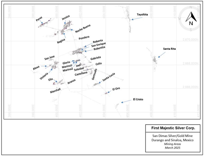
Note: Figure prepared by First Majestic, April 2025.
Both contractor and First Majestic personnel conduct mining activities. Two mining methods are currently being practiced at San Dimas, cut-and-fill and longhole mining. Cut-and-fill is carried out by either jumbo or jackleg drills. Primary access is provided by adits and internal ramps from an extensive tunnel system.
| 156 | September 2025 |
| San Dimas Silver/Gold Mine Durango and Sinaloa States, Mexico NI-43-101 Technical Report on Mineral Resource and Mineral Reserve Estimates |
|
| 16.2. | Mining Methods and Mine Design |
| 16.2.1. | Geotechnical Considerations |
Geotechnical data is primarily collected through geotechnical core logging and underground mapping at San Dimas which is recorded in company databases. Geotechnical core logging is performed on diamond drill core after geological logging, using standard methods to collect parameters for Q (Barton et al., 1974), Rock Mass Rating (RMR) (Bieniawski, Z.T., 1989) or Geological Strength Index (GSI) (Hoek, et al., 1997) systems. Underground geotechnical mapping is conducted by a ground control engineer (or delegate) using scan line, window, and frontal mapping techniques. This aims to collect parameters for Q, RMR, or GSI classification.
Rock mass qualities are assessed by domain (typically lithological units) with Q, RMR, or GSI classification systems. This allows ground conditions (e.g., strong/brittle, weak/faulted, highly jointed) to be assessed and understood. Hydrogeological conditions, where they occur and are relevant to stability are also included in the rock mass classification.
Underground: stope stability, crown pillar, backfill, and opening dimensions are assessed and reviewed by site personnel. Typical stability assessments methods used are empirical and numerical, including the improved unified constitutive model (IUCM) (Vakili, 2016) with FLAC3D software (Itasca, 2011).
A summary of key geotechnical units is presented in Table 16-1.
Table 16-1: San Dimas Geotechnical Units
|
Geotechnical Unit |
Rock Type / Description | Failure Probability |
Q Index |
Rock Quality | RMR Index |
|||||
| UNIT 1 | Granodiorite – Light gray/pink, good quality | Low | 40–100 | Very Good | 81–100 | |||||
| UNIT 2 | Andesite with rhyolite/andesite tuffs, weathered | Medium to Low | 10–40 | Good–Very Good |
61–80 | |||||
| UNIT 3 | Andesite with wedges and intense fracturing | Medium to High | 4–10 | Fair–Good | 41–60 | |||||
| UNIT 4 | Fine-grained andesite, high fracturing, water impact | High | 1–4 | Poor–Fair | 21–40 | |||||
| UNIT 5 | Fine-grained andesite with tuffs, highly fractured and clay-filled | Very High | 0.1–1 | Very Poor | 0–21 | |||||
Ground conditions throughout most of the San Dimas underground workings are considered good with Unit 3 being the predominant geotechnical unit, made up of productive andesite, rhyolite, and andesitic dikes. Bolting is used systematically in the main haulage ramps, drifts, and underground infrastructure. For those sectors that present unfavorable rock quality, shotcrete, mesh, and/or steel arches are used.
Recommended ground support applied various combination of typical items, such as bolts, welded wire mesh, shotcrete, and cable bolts. Standard ground support designs have been developed and are applied. An example of a typical ground support standard is outlined in Figure 16-2.
| 157 | September 2025 |
| San Dimas Silver/Gold Mine Durango and Sinaloa States, Mexico NI-43-101 Technical Report on Mineral Resource and Mineral Reserve Estimates |
|
Figure 16-2: Typical Ground Support Patterns
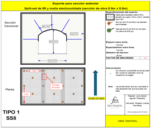
Note: Figure prepared by First Majestic, April 2025.
| 16.2.2. | Hydrogeological Considerations |
Groundwater inflow has not been a significant concern San Dimas and as a result it has not been studied in detail.
| 16.2.3. | Development and Access |
Access to the mining areas is achieved by adits and internal ramps. The main adits from the surface are shown in Figure 16-1. The Central Block and Sinaloa Graben regions rely solely on truck haulage, whereas Tayoltita ROM material is transported to the surface stockpile via rail. Main accesses are typically driven at 4 m wide by 4.5 m high, with accesses to the stopes at 3 m wide by 3 m high. Typical rail haulage way dimensions are 3.5 m wide by 3.5 m high. Main ramps are generally driven at a gradient of 15% as shown in Table 16-2.
The view shown in Figure 16-3 is an example of development adjacent to a vein, in this case the Perez vein.
| 158 | September 2025 |
| San Dimas Silver/Gold Mine Durango and Sinaloa States, Mexico NI-43-101 Technical Report on Mineral Resource and Mineral Reserve Estimates |
|
Table 16-2: Development Profiles
| Development Type |
Width (m) |
Height (m) |
Gradient (%) |
|||||
| Ramp (primary haulage) |
4.0 | 4.5 | ± | 15 | % | |||
| Secondary Ramp |
4.0 | 4.0 | ± | 15 | % | |||
| Stope-ramp |
3.0 | 3.5 | ± | 15 | % | |||
| Access longhole |
3.0 | 3.5 | + 0.5 | % | ||||
| Access cut-and-fill |
3.0 | 3.5 | -15 | % | ||||
| Muck-bay |
4.0 | 4.0 | + 0.5 | % | ||||
| Stockpile |
4.0 | 4.0 | + 0.5 | % | ||||
| Access ventilation |
4.0 | 4.0 | + 0.5 | % | ||||
| Sump |
2.5 | 2.5 | -17 | % | ||||
| Ore drifts |
3.0 | 3.5 | + 0.5 | % | ||||
| Safety bay |
2.5 | 2.5 | +1 | % | ||||
| Electrical bay |
2.5 | 2.5 | +1 | % | ||||
| Robbins station |
9.0 | 7.0 | +1 | % | ||||
| Drilling station |
6.0 | 6.0 | +1 | % | ||||
| Electrical substation |
6.0 | 6.0 | +1 | % | ||||
Figure 16-3: Perez Vein Development and Production
Note: Figure prepared by First Majestic, April 2025.
Internal ramps connect stopes from both the hanging wall and foot wall, and often, when two or more veins are in close proximity, a single ramp can provide access to multiple veins. In the case of the Perez
| 159 | September 2025 |
| San Dimas Silver/Gold Mine Durango and Sinaloa States, Mexico NI-43-101 Technical Report on Mineral Resource and Mineral Reserve Estimates |
|
vein ROM material is typically hauled out of the San Fernando drift and then deposited into ore passes to the San Luis tunnel where it is extracted by contractors to the plant. Material from the Graben Sinaloa zone is extracted through tunnel Graben with contractors to the plant.
Since the mine was acquired by First Majestic, the development rate can bee seen in the table below. Table 16-3.
Table 16-3: San Dimas Development 2018 to 2024
| Development |
Unit | 2018* | 2019 | 2020 | 2021 | 2022 | 2023 | 2024 | ||||||||||||||||||||||||
| Waste expansionary |
m | 1,426 | 2,595 | 2,018 | 5,604 | 3,548 | 2,195 | 6,915 | ||||||||||||||||||||||||
| Waste sustaining |
m | 5,592 | 11,373 | 11,929 | 11,821 | 11,908 | 8,483 | 7,370 | ||||||||||||||||||||||||
| Development in Ore |
m | 6,045 | 10,053 | 12,207 | 8,645 | 6,397 | 6,963 | 5,208 | ||||||||||||||||||||||||
|
|
|
|
|
|
|
|
|
|
|
|
|
|
|
|
|
|||||||||||||||||
| Total Development |
m | 13,063 | 24,021 | 26,154 | 26,070 | 21,853 | 17,641 | 19,493 | ||||||||||||||||||||||||
|
|
|
|
|
|
|
|
|
|
|
|
|
|
|
|
|
|||||||||||||||||
| * | Development May-Dec 2018 |
| 16.2.4. | Mining Methods and Stope Design |
The predominant mining methods at San Dimas are mechanized cut-and-fill and longhole mining. Longhole mining was introduced in 2012 and is becoming increasingly important.
Cut-and-fill mining is carried out using jumbo or jackleg drills and load-haul-dump (LHD) machines. Minimum mining widths of 3.5 m and 0.8 m for jumbo and jackleg mining, respectively, may be attainable. Waste rock is used as fill material and provides both wall support and a working base from which to take subsequent cuts after the initial sill cut.
Figure 16-4 is a representative long-section schematic showing the cut pattern followed after establishing accesses to the mineralized veins.
| 160 | September 2025 |
| San Dimas Silver/Gold Mine Durango and Sinaloa States, Mexico NI-43-101 Technical Report on Mineral Resource and Mineral Reserve Estimates |
|
Figure 16-4: Cut-and-Fill Long Section Schematic
Note: Figure prepared by First Majestic, April 2025.
During cut-and-fill mining, an initial 3.5 m high sill cut is typically taken followed by a second 3.0 m cut. Waste rock is then used to fill the void to about 1.0 m from the back, so as to form the working floor for the next cut. The next 3.0 m cut is then breasted down on top of the fill. When this mineralized material is mucked out, filling occurs again to within about 1.0 m of the back. The process is repeated until within about 4.0 m of the next sill cut. Sills beneath waste fill are mined using uppers. The general mining recovery factor is about 95%.
Longhole mining consists of drilling production holes into the pillar between two mineralized drifts. A minimum mining width of 1.2 m is envisaged for the method. A drop raise or an inverse raise is drilled and blasted at the extremity of the mining block. The length of the block is determined relative to the geotechnical condition of the exposed walls. Stopes can be mined either with upholes or downholes, with maximum heights of 1 from sill to sill. The longhole mining method offers increased productivity, lower unit operating costs, and reduced waste dilution in veins of consistent geometry. A typical long hole stope can be seen in the image in Figure 16-5.
| 161 | September 2025 |
| San Dimas Silver/Gold Mine Durango and Sinaloa States, Mexico NI-43-101 Technical Report on Mineral Resource and Mineral Reserve Estimates |
|
Figure 16-5: Schematic of Longhole Stoping
Note: Figure prepared by First Majestic, March 2025.
Drilling at San Dimas is done with top hammer rigs Stope mates (pneumatic drilling rigs), and Raptors (electric drilling rigs) and is typically drilled uphole, although downhole stopes may be designed in instances where conditions permit it. The hole diameter is 64mm and guide and stabilizing rods are used to increase drilling precision and minimize deviation. A typical drill section layout of a production stope is shown in Figure 16-6. A typical section of an uphole longhole drill layout plan is shown in Figure 16-7.
| 162 | September 2025 |
| San Dimas Silver/Gold Mine Durango and Sinaloa States, Mexico NI-43-101 Technical Report on Mineral Resource and Mineral Reserve Estimates |
|
Figure 16-6: Section of Typical Drill Layout for a Production Stope
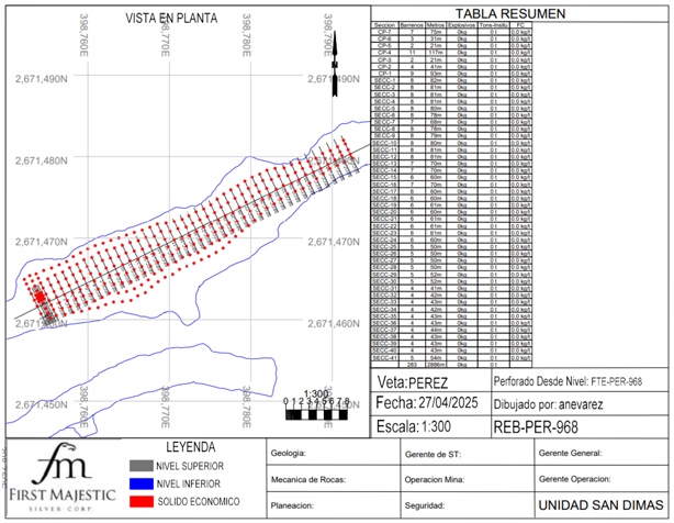
Note: Figure prepared by First Majestic, March 2025.
| 163 | September 2025 |
| San Dimas Silver/Gold Mine Durango and Sinaloa States, Mexico NI-43-101 Technical Report on Mineral Resource and Mineral Reserve Estimates |
|
Figure 16-7: Longhole Uphole Stope Section
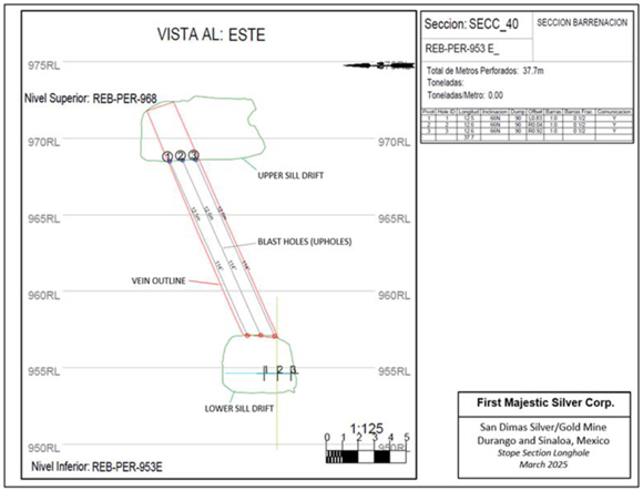
Note: Figure prepared by First Majestic, March 2025.
Twelve-metre long upholes are drilled from the lower drift to communicate to the upper drift to remove all of the material. In areas where a sill pillar is left the holes are cut 3m short of break through. Where possible, holes are drilled along the contact of the vein, and typical overbreak on the hanging-wall and footwall is approximately 0.4 m. San Dimas has regularly mined veins less than 1 m in width with success using this method. All stopes in San Dimas are either left void or filled with ROM waste rock.
The explosive primarily used in San Dimas is ANFO due to its cost effectiveness and simplicity of use in dry mine conditions. For longhole blasting ANFO is transported to the stope in 25kg bags where it is pressurized in a kettle loader and injected and compacted into the upholes leaving a 1.5m void collar. In the instance of blasting down holes, the ANFO is poured into the hole until the require column has been filled. There is minor water inflow in San Dimas underground but when the stope holes are wet an emulsion cartridge loader (Can-Blast) is used to inject 2”x16” emulsion stick into the hole. All holes are initiated with an electronic detonator and one detonator is inserted at the toe and an additional det is inserted at 6 meters.
For drift blasting, ANFO is used when conditions are dry for the cut, and for center body of holes, perimeter blasting is implemented by using low density stick emulsion in the back holes to reduce dilution and scaling requirements increasing cycle times for development.
A sample development blast plan can be seen below in Figure 16-8
| 164 | September 2025 |
| San Dimas Silver/Gold Mine Durango and Sinaloa States, Mexico NI-43-101 Technical Report on Mineral Resource and Mineral Reserve Estimates |
|
Figure 16-8: Ore Development Blast Drill Plan
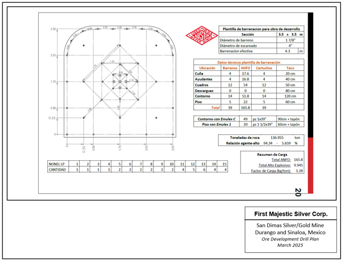
Note: Figure prepared by First Majestic, March 2025.
| 16.2.5. | Ore and Waste Haulage |
Ore is hauled from the underground mine to the surface by means of 14 m3 conventional trucks. Most truck haulage at San Dimas is carried out by contractors, however First Majestic has 11 trucks used for material transfers inside the mine.
To transfer material between underground levels, a system of reamed and conventional ore-passes is used.
Ore from the three mine areas, Central Block, West Block, and Sinaloa Graben, is hauled to the mill site via three main tunnels know as the San Luis, Tunnel Graben, and San Francisco tunnels. The mine is setup with a series of ore passes that connect the stopes areas to the haulage levels for the material to flow and to be loaded and hauled to surface and the plant, where it is sampled by ore control and separated into high, medium and low grade stockpiles for blending before being fed to the plant. The ROM material from the Tayoltita mine sector is be transported by rail to the mill.
| 165 | September 2025 |
| San Dimas Silver/Gold Mine Durango and Sinaloa States, Mexico NI-43-101 Technical Report on Mineral Resource and Mineral Reserve Estimates |
|
Development waste is generally moved to stopes as backfill with a limited surplus hauled to surface and stored in the waste storage facility known as La Herradura.
| 16.3. | Mine Infrastructure |
This subsection provides an overview of the infrastructure located within or directly connected to the underground mine. The QP is of the opinion that the underground infrastructure, mine services, and fixed equipment are well-suited to the scale and conditions of the underground operations. During the site visit, the QP observed that these installations are of high quality, fully operational, and functioning as intended.
| 16.3.1. | Mine Access and Underground Facilities |
San Dimas contains an operational track and railcars at the Tayoltita mine. Santa Rita mine, Graben-Sinaloa, Central block and West block are trackless operations are accessed by three main portals, the San Francisco Tunnel, and San Luis Tunnel which support the West block and Central block, and the Graben Tunnel which supports the Graben-Sinaloa zone. These zones are connected underground by tunnels and, providing access to each area without the need to return to surface. Santa Rita, and Tayoltita mines are isolated from the other mine operations and can only be accessed through their respective portals.
| 16.3.2. | Ventilation |
The San Dimas ventilation system consists of an exhaust air extraction system through its main fans located on surface. These fans generate the necessary pressure change for fresh air to enter through the portals and ventilation raises.
Figure 16-9 shows the ventilation connections among the different mine sectors in San Dimas, and the location for the fans, ventilation raises, and main portals.
| 166 | September 2025 |
| San Dimas Silver/Gold Mine Durango and Sinaloa States, Mexico NI-43-101 Technical Report on Mineral Resource and Mineral Reserve Estimates |
|
Figure 16-9: Ventilation System
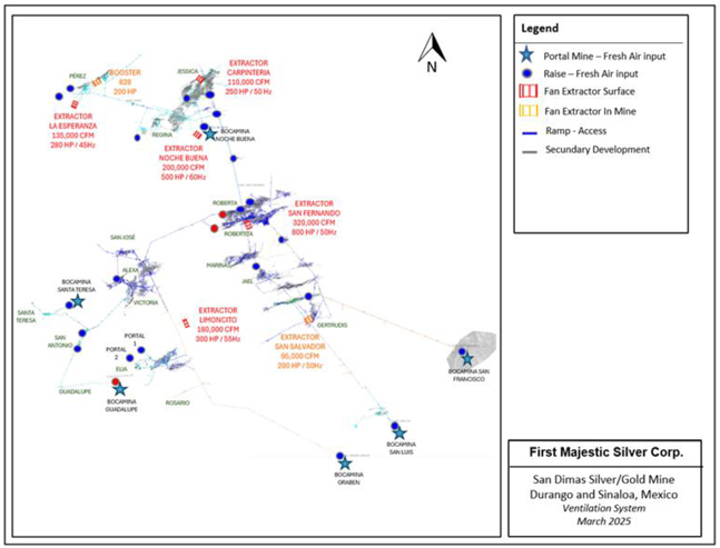
Note: Figure prepared by First Majestic, March 2025.
First Majestic personnel constantly monitor the system and the quality of the air. The software used to model the performance of the ventilation system and to design the required ventilation infrastructure is Ventsim.
The main ventilation system has a capacity of 1,125,000 cubic feet per minute (cfm) totalling 2,350 installed horsepower (HP). It is made up of seven fans in total, of which two are currently inactive. The total capacity is sufficient to provide the 774,120 cfm that are needed for personnel, equipment, and explosive gas dilution requirements. The fresh-air needs are shown in
| 167 | September 2025 |
| San Dimas Silver/Gold Mine Durango and Sinaloa States, Mexico NI-43-101 Technical Report on Mineral Resource and Mineral Reserve Estimates |
|
Table 16-4.
| 168 | September 2025 |
| San Dimas Silver/Gold Mine Durango and Sinaloa States, Mexico NI-43-101 Technical Report on Mineral Resource and Mineral Reserve Estimates |
|
Table 16-4: Fresh Air Requirement
| Area |
Request | |||||||||||||||
| Personnel (cfm) |
Equipment (cfm) |
Explosives (cfm) |
Total (cfm) |
|||||||||||||
| Elia |
1,060 | 46,125 | 5.32 | 47,190 | ||||||||||||
| Victoria |
1,007 | 6,855 | 5.25 | 7,867 | ||||||||||||
| San Antonio |
1,166 | 24,750 | 4.37 | 40,653 | ||||||||||||
| Santa Teresa |
1,908 | 77,925 | 1.75 | 79,839 | ||||||||||||
| Jessica |
2,915 | 119,595 | 24.49 | 122,534 | ||||||||||||
| Perez-Sn Vicente |
2,173 | 210,338 | 20.8 | 212,531 | ||||||||||||
| Regina |
2,279 | 74,048 | 70.98 | 21,845 | ||||||||||||
| Gertrudis |
1,961 | 59,993 | 25.01 | 61,979 | ||||||||||||
| Jael |
1,325 | 27,900 | 4.37 | 29,229 | ||||||||||||
| El Oro |
1,696 | 48,450 | 4.37 | 50,150 | ||||||||||||
| Robertas |
1,696 | 48,450 | 4.37 | 50,150 | ||||||||||||
| Marina 2 |
1,696 | 48,450 | 4.37 | 50,150 | ||||||||||||
| Total |
20,882 | 792,878 | 175.45 | 774,120 | ||||||||||||
|
|
|
|
|
|
|
|
|
|||||||||
As part of the ventilation system, the mine uses secondary fans with capacities ranging from 30.5 to 100 hp. These secondary fans are used to bring fresh air over to the developments faces to provide fresh air and remove dust and fumes.
| 16.3.3. | Backfill |
The waste material from the main underground infrastructure development is used as backfill for longhole and cut-and-fill stopes. The rock size distribution is adequate to stabilize the cavities and no cement is needed. The back-filling process is carried out with the same equipment used for mucking and hauling.
| 16.3.4. | Dewatering |
Dewatering systems in San Dimas consist of main and auxiliary pumps in place at each of the mine areas. In the Central Block, main pumps of 100, 150, and 300 hp provide a combined capacity of approximately 1,500 gallons per minute (gpm); actual quantities pumped to surface are in the 400–500 gpm range. In the Sinaloa Graben area, there are three 40 hp pumps with a capacity of 250 gpm. One 30 hp pump gives around 220 gpm capacity in the Tayoltita area. Santa Rita has 330 gpm capacity from a 150 hp pump.
Additional pumping requirements and necessary extensions to individual systems were identified and included in the sustaining capital budget.
| 169 | September 2025 |
| San Dimas Silver/Gold Mine Durango and Sinaloa States, Mexico NI-43-101 Technical Report on Mineral Resource and Mineral Reserve Estimates |
|
| 16.3.5. | Mine Water Supply |
Water supply for diamond drilling and other mining activities in the Central Block is provided by one water pump with a capacity of 185 gpm each. When possible, the Central Block recycles underground drainage water and otherwise sources water from wells shared by other infrastructure. Figure 16-10 shows the method to clean up the water through a sump system. Most of the water in the Sinaloa Graben sector is from recirculating sumps.
Figure 16-10: Pumps Station Typical Arrangement
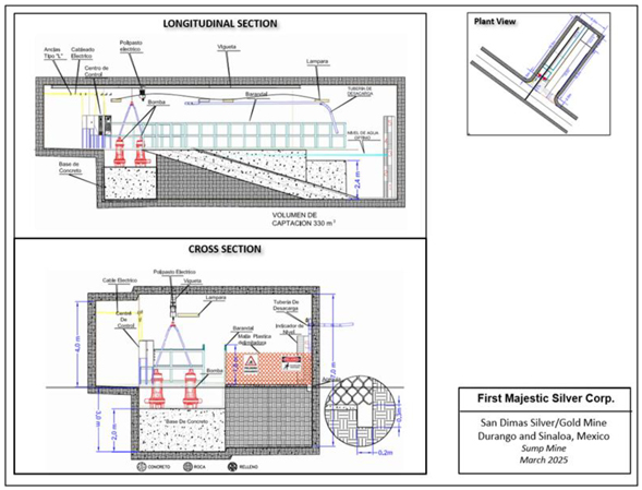
Note: Figure prepared by First Majestic, March 2025.
| 16.3.6. | Power Supply |
Electric power is provided by a combination of First Majestic’s own power generated through its “Las Truchas” hydroelectric plant (38%), the national power grid operated by the Federal Energy Commission (CFE) (49%), and as needed, rented or owned diesel generation (13%). Diesel generation is planned to be replaced in 2025 with new LNG energy production. Section 18.4 describes in more detail the distribution and consumption of electrical power in San Dimas.
| 170 | September 2025 |
| San Dimas Silver/Gold Mine Durango and Sinaloa States, Mexico NI-43-101 Technical Report on Mineral Resource and Mineral Reserve Estimates |
|
| 16.3.7. | Compressed Air |
There are 12 stationary air compressors installed in the mine, distributed among the different operational sectors. The compressors are used for distinct kinds of services, including exploration drilling. The capacity of the stationary air compressors varies from 900 to 1,300 cfm and delivers a total installed capacity of 11,700 cfm.
There are another six mobile electric compressors dedicated to assisting the production drilling (longhole). The total capacity of the mobile compressors is 6,500 cfm.
| 16.3.8. | Explosives |
The general magazine for the San Dimas operation is located on surface. It has the capacity to store the explosives required for all the production and development areas. It complies with all the current permits and authorizations which were granted by the Ministry of National Defense (SEDENA). The storage is correctly sectorized between high explosives, agents, and initiators, as requested by the authorities. The explosives are distributed to the working areas in safety trucks. There is an internal procedure implemented and monitored by the company to hand out the explosives.
| 16.4. | Development Schedule |
Based on the current LOM plan, San Dimas will develop an average of 7.5 km of waste development and 6 km of ore development per year for the next five years. The LOM total is 32 km of lateral waste development, 3 km of vertical development and 30 km of development in ore as shown in Table 16-5.
Table 16-5: San Dimas Life of Mine Development Schedule
| Type |
Units | Size (m) | 2025 | 2026 | 2027 | 2028 | 2029 | Total | ||||||||||||||||||||||||
| Main Access Ramp |
m | 4.5x4.5 | 2,378 | 2,385 | 2,385 | 2,578 | 586 | 10,313 | ||||||||||||||||||||||||
| Main Level Access |
m | 4.5x4.5 | 2,101 | 2,107 | 2,107 | 2,277 | 518 | 9,109 | ||||||||||||||||||||||||
| Ancillary |
m | 3.5x3.5 | 1,229 | 1,232 | 1,232 | 1,332 | 303 | 5,328 | ||||||||||||||||||||||||
| Drifting for Exploration |
m | 4.5x4.5 | 1,821 | 1,826 | 1,826 | 2,016 | 469 | 7,958 | ||||||||||||||||||||||||
| Ventilation Raises |
m | 2.5 diam | 1,009 | 1,067 | 580 | 446 | 51 | 3,153 | ||||||||||||||||||||||||
|
|
|
|
|
|
|
|
|
|
|
|
|
|||||||||||||||||||||
| Total Waste Development |
m | 8,538 | 8,617 | 8,130 | 8,649 | 1,926 | 35,860 | |||||||||||||||||||||||||
|
|
|
|
|
|
|
|
|
|
|
|
|
|||||||||||||||||||||
| Ore Development |
m | 3.5x3.5 | 6,783 | 6,802 | 6,802 | 6,326 | 3,353 | 30,066 | ||||||||||||||||||||||||
|
|
|
|
|
|
|
|
|
|
|
|
|
|||||||||||||||||||||
| Total Development |
m | 15,321 | 15,418 | 14,932 | 14,975 | 5,279 | 65,926 | |||||||||||||||||||||||||
|
|
|
|
|
|
|
|
|
|
|
|
|
|||||||||||||||||||||
| 16.5. | Production Schedule |
The development and production schedules were developed in Deswik and Excel based on the San Dimas mine design standards and considering previous performance indicators for production and development rates. The schedule tracks and reports development metres and stope production for each domain on a
| 171 | September 2025 |
| San Dimas Silver/Gold Mine Durango and Sinaloa States, Mexico NI-43-101 Technical Report on Mineral Resource and Mineral Reserve Estimates |
|
monthly basis. These schedules are used as inputs to an economic model to review if positive cashflow is obtained.
The production schedule assumes that the cut-and-fill and longhole stopes will continue to perform as they have historically and that all mining will be from the Mineral Reserves.
Based on historic performance, it is expected that First Majestic will be mining some material that is not currently classified as Mineral Reserves, this material is commonly found when drifting towards exploration targets and mineralized structures are found. In addition, some extensions to the modelled veins are extracted during normal course of mining. This material is neither estimated nor considered in the production schedule incorporated into the economic model.
The production schedule for the LOM plan is presented in Table 16-6.
Table 16-6: San Dimas Life of Mine Production Schedule
| Type |
Units | 2025 | 2026 | 2027 | 2028 | 2029 | Total | |||||||||||||||||||
| ROM Production / Plant Feed |
kt | 629 | 631 | 631 | 631 | 708 | 3229 | |||||||||||||||||||
| Silver Grade |
g/t Ag | 285 | 285 | 285 | 285 | 153 | 245 | |||||||||||||||||||
| Gold Grade |
g/t Au | 2.83 | 2.83 | 2.83 | 2.83 | 2.86 | 2.84 | |||||||||||||||||||
| Silver-Equivalent Grade |
g/t Ag-Eq | 532 | 532 | 532 | 532 | 403 | 493 | |||||||||||||||||||
|
|
|
|
|
|
|
|
|
|
|
|
|
|||||||||||||||
| Contained Silver |
M oz Ag | 5.8 | 5.8 | 5.8 | 5.8 | 3.5 | 25 | |||||||||||||||||||
| Contained Gold |
k oz Au | 57 | 57 | 57 | 57 | 65 | 294 | |||||||||||||||||||
| Contained Silver-Equivilent |
M oz Ag-Eq | 10.8 | 10.8 | 10.8 | 10.8 | 9.2 | 51 | |||||||||||||||||||
|
|
|
|
|
|
|
|
|
|
|
|
|
|||||||||||||||
| Metallurgical Recovery Silver |
% | 94.9 | % | 92.6 | % | 92.6 | % | 92.6 | % | 92.6 | % | 93.1 | % | |||||||||||||
| Metallurgical Recovery Gold |
% | 95.1 | % | 95.6 | % | 95.6 | % | 95.6 | % | 95.6 | % | 95.5 | % | |||||||||||||
|
|
|
|
|
|
|
|
|
|
|
|
|
|||||||||||||||
| Produced Silver |
M Oz Ag | 5.5 | 5.4 | 5.4 | 5.4 | 3.2 | 24 | |||||||||||||||||||
| Produced Gold |
k Oz Au | 54 | 55 | 55 | 55 | 62 | 281 | |||||||||||||||||||
| Produced Silver-Equivalent |
M oz Ag-Eq | 10.2 | 10.1 | 10.1 | 10.1 | 8.7 | 48 | |||||||||||||||||||
|
|
|
|
|
|
|
|
|
|
|
|
|
|||||||||||||||
A total of 3.2 Mt of ore is considered to be mined and processed with grades of 245 g/t Ag and 2.84 g/t Au. Total metal produced is estimated at 25 Moz Ag and 294 Koz Au.
| 16.6. | Equipment and Manpower |
The workforce at San Dimas is made up of company personnel (staff and unionized) and contractor personnel.
| 172 | September 2025 |
| San Dimas Silver/Gold Mine Durango and Sinaloa States, Mexico NI-43-101 Technical Report on Mineral Resource and Mineral Reserve Estimates |
|
Table 16-7 is a breakdown of personnel on site as of May 2025, which is considered sufficient for to the requirements of the LOM plan.
| 173 | September 2025 |
| San Dimas Silver/Gold Mine Durango and Sinaloa States, Mexico NI-43-101 Technical Report on Mineral Resource and Mineral Reserve Estimates |
|
Table 16-7: Breakdown of Personnel as of May 2025
| Area |
Union | Staff | Contractor | Total | ||||||||||||
| Administration |
2 | 32 | 13 | 47 | ||||||||||||
| Geology and Exploration |
32 | 74 | 141 | 247 | ||||||||||||
| Technical Services |
12 | 29 | 0 | 41 | ||||||||||||
| Mine Operations |
377 | 52 | 343 | 772 | ||||||||||||
| Mine Maintenance |
123 | 47 | 37 | 207 | ||||||||||||
| Mine Services |
30 | 19 | 0 | 49 | ||||||||||||
| Processing Plant |
128 | 24 | 19 | 171 | ||||||||||||
| Plant Maintenance |
57 | 25 | 11 | 93 | ||||||||||||
| Assays Lab |
0 | 23 | 0 | 23 | ||||||||||||
| Supply Chain |
29 | 21 | 0 | 50 | ||||||||||||
| Human Resources & Camp |
0 | 40 | 76 | 116 | ||||||||||||
| Airline |
0 | 9 | 0 | 9 | ||||||||||||
| CSR |
0 | 7 | 6 | 13 | ||||||||||||
|
|
|
|
|
|
|
|
|
|||||||||
| Total |
790 | 402 | 646 | 1838 | ||||||||||||
|
|
|
|
|
|
|
|
|
|||||||||
Table 16-8 is a summary of mine equipment on site as of December 2024, which is considered sufficient for the requirements of the LOM plan.
Table 16-8: Equipment Summary as of December 2024
| Equipment |
Capacity | Number | Total | |||||||
| Jumbos | 12 ft | 4 | 16 | |||||||
| 14 ft | 1 | |||||||||
| 16 ft | 11 | |||||||||
| Rock support drills | 8 ft | 4 | 7 | |||||||
| 6ft | 3 | |||||||||
| Longhole drills | 20 mt | 8 | 8 | |||||||
| LHDs | 1.5 cu yd | 7 | 29 | |||||||
| 2 cu yd | 2 | |||||||||
| 3 cu yd | 3 | |||||||||
| 4 cu yd | 9 | |||||||||
| 6 cu yd | 6 | |||||||||
| 8 cu yd | 2 | |||||||||
| Trucks | 10 tonne | 6 | 11 | |||||||
| 15 tonne | 5 | |||||||||
| Raiseboring machines | 6 ft | 1 | 2 | |||||||
| 7-8 ft | 1 | |||||||||
| Ancillary vehicles | — | 32 | 32 | |||||||
| Utility vehicles | — | 120 | 120 | |||||||
| 174 | September 2025 |
| San Dimas Silver/Gold Mine Durango and Sinaloa States, Mexico NI-43-101 Technical Report on Mineral Resource and Mineral Reserve Estimates |
|
| 17. | RECOVERY METHODS |
| 17.1. | Introduction |
The San Dimas processing plant is composed of the following operating units:
| • | Crushing: A two-stage circuit featuring a primary jaw crusher and a secondary cone crusher (with one unit operating and one on standby), configured in closed circuit with a dry vibrating double-deck 8’x16’ screen. |
| • | Grinding: Three ball mills running in parallel, each connected to two hydrocyclones in closed circuit, with one cyclone operating and one on standby. |
| • | Cyanide Leaching: Leaching of plant-feed using cyanide in a series of 16 agitated tanks, supported by two intermediate thickeners. |
| • | Counter Current Decantation (CCD): Two CCD thickeners operating in series for slurry washing prior to filtration. |
| • | Merrill-Crowe and Smelting: Zinc precipitation followed by doré production in the on-site smelting facility. |
| • | Filtration Plant: Four horizontal vacuum belt filters working in parallel, located adjacent to the Tailings Storage Facility. |
| 17.2. | Process Flowsheet |
Figure 7-1 and Figure 7-2 illustrate the crushing circuit and the overall plant flowsheet, respectively.
| 175 | September 2025 |
| San Dimas Silver/Gold Mine Durango and Sinaloa States, Mexico NI-43-101 Technical Report on Mineral Resource and Mineral Reserve Estimates |
|
Figure 17-1: San Dimas Schematic Crushing Plant Flowsheet
Note: Figure prepared by First Majestic, April 2025.
Figure 17-2: San Dimas Processing Plant Flowsheet
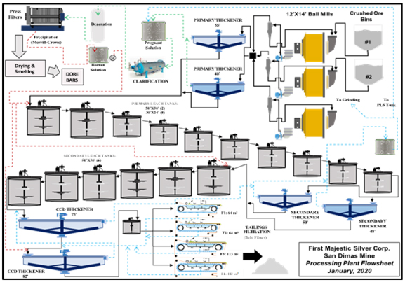
Note: Figure prepared by First Majestic, April 2025
| 176 | September 2025 |
| San Dimas Silver/Gold Mine Durango and Sinaloa States, Mexico NI-43-101 Technical Report on Mineral Resource and Mineral Reserve Estimates |
|
| 17.3. | Processing Plant Configuration |
The San Dimas processing plant operates as a single train, with the crushing area separated from the rest of the circuit and linked by a belt conveyor that transfers screened material to the fine-ore bins. The remaining sections of the plant include the grinding circuits, leach tanks, CCD thickeners, Merrill-Crowe circuit, smelting facility, and the tailings filtration and stacking area.
| 17.3.1. | Plant Feed |
Run-of-mine material from the mines is delivered to a 1,000-tonne capacity steel coarse ore bin equipped with a static screen featuring 12 x 12-inch apertures. Oversized material retained on the screen is broken down using a hydraulic hammer.
| 17.3.2. | Crushing |
The crushing circuit is designed as a two-stage size reduction process, comprising primary and secondary crushing. Coarse ROM ore is discharged from the ROM bin onto a vibrating grizzly feeder, which scalps the -18” +4” fraction for primary crushing. This material is processed by a 20” x 36” primary jaw crusher, operating at a closed side setting (CSS) of 3” to 31⁄2”. The crushed product is conveyed to a 450-tonne capacity secondary surge bin.
Material from the secondary bin is fed to an 8’ x 16’ double-deck vibrating screen. The top deck is fitted with slotted apertures measuring 1” x 11⁄2”, while the lower deck utilizes 1⁄2” x 1⁄2” openings. The screen undersize (product) typically achieves 90–95% passing 5/16” (8 mm), with an average of 70% passing 1⁄4” (6.4 mm).
Oversize material from the vibrating screen is directed to one of two 7’ Symons short head secondary cone crushers, each operated at a CSS of 3/8” to 1⁄2”. One unit operates continuously, while the second remains on standby. Secondary crushing reduces the oversize to approximately -5/16”, which is recycled as circulating load back to the vibrating screen feed.
The final undersize product from the vibrating screen is conveyed to two fine ore storage bins (Bins 3 and 4), each with a live capacity of 1,300 metric tonnes. The fine crushed ore product maintains a particle size distribution of 90–95% passing 5/16” (8 mm) and an average moisture content of 3%.
The installed capacity of the crushing plant is rated at 220 tonnes per hour (t/h).
| 17.3.3. | Grinding |
The grinding circuit comprises three identical ball mills operating in parallel. Each mill has a diameter of 12 feet and a length of 14 feet, driven by a 1,500 HP motor. Classification is performed using Krebs D-20” gMax cyclones, one per grinding line. Each cyclone cluster is supported by a pair of slurry pumps, one
| 177 | September 2025 |
| San Dimas Silver/Gold Mine Durango and Sinaloa States, Mexico NI-43-101 Technical Report on Mineral Resource and Mineral Reserve Estimates |
|
operating and one on standby to ensure continuous operation. The grinding media consists exclusively of 3” diameter forged steel balls.
Crushed ore from the fine ore storage bins is conveyed via belt feeders to the ball mills. Reagent addition within the grinding circuit includes:
| • | Cyanide solution: Semi-pregnant solution with cyanide concentrations ranging from 2,500 to 3,000 ppm is utilized as process water. Fresh cyanide is dosed to maintain a target concentration of 4,000 ppm within the grinding circuit. |
| • | Lime: Added to the crushed ore conveyor prior to mill feed, with an average consumption rate of 1.80 kg per tonne of ore processed. |
The grinding circuit is designed to achieve a final product with approximately 70% passing 200 mesh (74 µm), corresponding to a P80 of 90 µm. Cyclone overflow, representing the final ground product, gravitates to a trash screen to remove oversize debris before reporting to two high-capacity primary thickeners operating in parallel. The thickeners have diameters of 55 feet and 48 feet, each with a sidewall height of 12 feet.
| 17.3.4. | Cyanide Leaching Circuit |
Leaching at the San Dimas plant involves the controlled addition of reagents and a two-stage thickening and leaching process designed to optimize metal recovery.
Reagent Addition and Dosages:
| • | Cyanide is added in briquette form at five points—ball mills, and leach tanks 1, 5, 9, and 12—to maintain a cyanide concentration between 3,500 and 4,000 ppm. Cyanide consumption ranges from 1.80 to 2.00 kg/t. |
| • | Lime, as previously described, is added before the grinding circuit to control leach pH. |
The slurry from the grinding circuit is split into two streams, each feeding a primary thickener: Westpro high-capacity units measuring 55’ x 12’ and 48’ x 12’. An anionic flocculant is dosed at 0.11% concentration, equivalent to 25 g/t, to promote solids settling. These thickeners serve two purposes: adjusting the pulp density ahead of agitated leaching and recovering pregnant leach solution (PLS) in the overflow, which is sent to the Merrill-Crowe zinc precipitation circuit.
The thickener overflow, PLS, is transferred to a storage tank, which feeds three 12 m³ Auto-Jet clarifier filters where perlite is used as a filtration aid. Meanwhile, the thickener underflow with a pulp density of 1.55 kg/L (58% solids) is diluted with barren solution to a density of 1.40 kg/L (46% solids) before entering the leach tanks.
The primary leaching stage consists of ten agitated tanks operating in series. Tanks #1 and #2 are 50 feet in diameter and 30 feet tall, while tanks #3 to #10 are 30 feet in diameter and 24 feet tall. Low-pressure air is injected into all tanks to maintain approximately 5 ppm of dissolved oxygen, which enhances gold
| 178 | September 2025 |
| San Dimas Silver/Gold Mine Durango and Sinaloa States, Mexico NI-43-101 Technical Report on Mineral Resource and Mineral Reserve Estimates |
|
and silver dissolution.
After primary leaching, the slurry is directed to two intermediate (secondary) thickeners: a 50’ x 12’ Delkor unit and a 48’ x 10’ Westpro thickener. The overflow solution is collected in a semi-pregnant solution tank. Most of this solution recycles to the primary thickener feed or to the PLS tank feeding the Auto-Jet filters, while the remainder is reused in the grinding circuit.
The thickener underflow is pumped to a second leaching stage consisting of six agitated tanks (50’ x 30’ each), equipped with the same low-pressure air injection system and operated under the same parameters as the primary leach tanks. This final leaching stage ensures optimal metal recovery before solution separation and downstream processing.
| 17.3.5. | Counter Current Decantation (CCD) System |
Slurry from the final agitated leach tank is directed to the counter-current decantation (CCD) circuit, which consists of two thickeners operating in series. The first stage utilizes a Delkor thickener with a diameter of 75 feet and a sidewall height of 12 feet, followed by a second stage Outotec thickener measuring 82 feet in diameter and 12 feet in height.
Underflow from CCD #2 is pumped to the final tailings storage tank, which serves as the feed reservoir for three Putzmeister HPS-1500 positive displacement pumps (two duty, one standby). These pumps transfer the tailings slurry to the filtration plant for dewatering.
The overflow from CCD #2 is recycled to the feed of CCD #1, where it mixes with fresh slurry from leach tank #16. CCD #2 also receives barren solution from the Merrill-Crowe filter press circuit, along with filtrate from the tailings filtration plant, thereby completing the counter-current washing sequence.
Overflow from CCD #1 is collected in the semi-pregnant solution receiver tank, where it combines with overflow streams from the intermediate thickener tanks. This solution is subsequently processed downstream.
| 17.3.6. | Merrill Crowe Zinc Precipitation and Smelting |
Pregnant solution is first directed to a storage tank, where turbidity averages approximately 40 nephelometric turbidity units (NTU). The solution is then processed through three auto-jet pressure clarifiers for filtration and clarification. Post-filtration, the clarified solution achieves turbidity levels below 1 NTU.
The clarified pregnant solution is subsequently pumped to a de-aeration tower designed for dissolved oxygen removal. This process reduces dissolved oxygen concentrations from approximately 5 ppm to below 1 ppm, optimizing conditions for downstream zinc precipitation.
| 179 | September 2025 |
| San Dimas Silver/Gold Mine Durango and Sinaloa States, Mexico NI-43-101 Technical Report on Mineral Resource and Mineral Reserve Estimates |
|
Following de-aeration, the solution is pumped to five filter presses, each 1,500 mm in size and equipped with 62 plates. Prior to filtration, zinc dust is added to the solution to initiate the Merrill-Crowe zinc precipitation reaction. Zinc consumption averages 1.4 kg per kilogram of doré produced.
The circuit processes pregnant solution at a throughput of approximately 550 m³/h, with an average metal content of ~38 ppm silver (Ag) and ~0.7 ppm gold (Au).
The resulting precious metal precipitate is dried in a Holo-Flite screw dryer operating at 225°C, with a nominal capacity of 600 kg/h. Dried precipitate is then smelted in a 1,000 kg capacity induction furnace utilizing silicon carbide crucibles at an operating temperature of 1,100°C. Doré bars produced from this process weigh approximately 32 kg each, with a typical purity of less than 97%.
The flux blend used during smelting consists of 7% borax, 7% sodium nitrate, and 0.7% soda ash, ensuring effective slag formation and metal recovery.
| 17.3.7. | Tailings Filtration and Management |
Three Putzmeister positive displacement pumps transfer final tailings slurry from the processing plant to the tailings filtration plant. The slurry is pumped through a 6-inch diameter pipeline, approximately 2 km in length, with a total static lift of 125 meters above pump elevation. The tailings slurry is delivered with a solids content ranging from 56% to 58% by weight.
At the filtration plant, tailings are processed using four horizontal belt filters. The facility includes two units with a filtration area of 64 m² each, and two larger units with a filtration area of 113 m² each. The resulting filter cake is discharged with a residual moisture content of 22% to 24%.
The dewatered tailings are then transported and compacted within designated areas of the Tailings Storage Facility (TSF).
Filtrate solution recovered from the tailings filtration process is returned to CCD Thickener #2 in the process plant, operating as part of a closed-loop circuit. This recirculation system achieves a solution recovery efficiency exceeding 70%.
| 17.3.8. | Sampling |
Process control and metallurgical balance sampling is conducted across the plant using both automatic and manual methods:
| • | Automatic sampling is performed on: |
| • | The plant feed conveyor belts for each of the three mills. |
| • | The final tailings at the CCD thickener discharge. |
| • | Manual sampling is performed at the following points: |
| • | Cyclone overflows. |
| • | Pregnant leach solution. |
| 180 | September 2025 |
| San Dimas Silver/Gold Mine Durango and Sinaloa States, Mexico NI-43-101 Technical Report on Mineral Resource and Mineral Reserve Estimates |
|
| • | Barren solution. |
| • | Final tailings (belt filter cake). |
| • | All leach tanks. |
| • | Filtrate solution. |
| • | Semi-pregnant solution used for grinding and intermediate washing. |
Sample increments are collected every 15 minutes, and a composite sample is generated for each eight-hour shift. All samples are prepared and assayed at the San Dimas Laboratory.
Based on these results, a daily metallurgical balance is calculated. This balance provides the gold and silver grades, as well as the metal content of the plant feed, tailings, and both the pregnant and barren solutions.
| 181 | September 2025 |
| San Dimas Silver/Gold Mine Durango and Sinaloa States, Mexico NI-43-101 Technical Report on Mineral Resource and Mineral Reserve Estimates |
|
| 18. | PROJECT INFRASTRUCTURE |
| 18.1. | Local Infrastructure |
The main infrastructure at San Dimas consists of access roads, the San Dimas mines, which are divided into five mining areas, crushing and processing facilities known as the Tayoltita mill, the Tayoltita/Cupias tailings facilities, an assay laboratory, offices and staff camp, the Las Truchas hydro-electric generation facilities, a diesel-powered emergency generation plant, a local airport and infrastructure supporting the inhabitants of the Tayoltita townsite including a local clinic, schools and sport facilities. The main administrative offices and employee houses are located in Tayoltita, along the southern bank of the Piaxtla River, while the warehouses, assay laboratory, core shack and other facilities are located on the north bank. Figure 18-1 shows the local infrastructure.
Figure 18-1: San Dimas Infrastructure Map
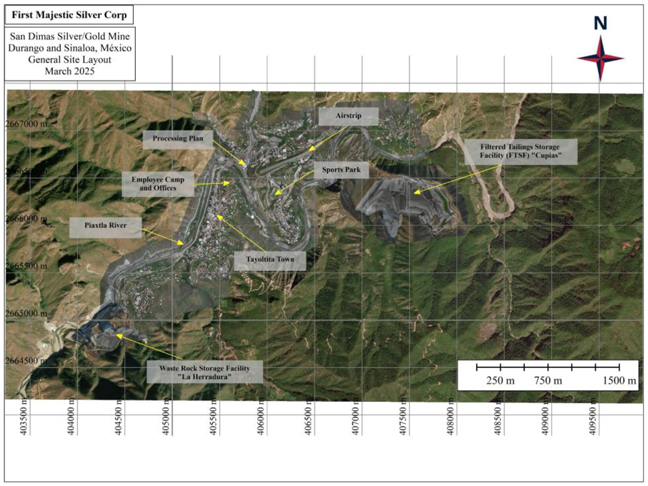
Note: Figure prepared by First Majestic, April 2025.
| 182 | September 2025 |
| San Dimas Silver/Gold Mine Durango and Sinaloa States, Mexico NI-43-101 Technical Report on Mineral Resource and Mineral Reserve Estimates |
|
| 18.2. | Transportation and Logistics |
Most of the personnel and light supplies for San Dimas arrive on First Majestic’s regular flights from Mazatlán and Durango. Heavy equipment and main supplies are brought by road from Durango and Mazatlán. Access details are described in Section 5.1.
| 18.3. | Waste Rock Storage Facilities |
The La Herradura waste rock storage facility (WRSF) is located approximately 1.8 km southwest of Tayoltita and has the capacity to store 1.6 Mt of waste rock and has an expected service life of 4 years which is sufficient for the waste material produced in the LOM plan presented in this Technical Report.
This facility holds waste rock generated from underground development, which is transported to the surface and placed at the bottom of both starter dikes NW and NE. The embankment construction follows the ascending construction with a terracing method. Since one of the underground mining methods used is primarily cut-and-fill, only a limited amount of waste is stored on the surface and may eventually be a source of backfill for stopes mined at depth.
| 183 | September 2025 |
| San Dimas Silver/Gold Mine Durango and Sinaloa States, Mexico NI-43-101 Technical Report on Mineral Resource and Mineral Reserve Estimates |
|
Figure 18-2 : Waste Rock Storage Facility
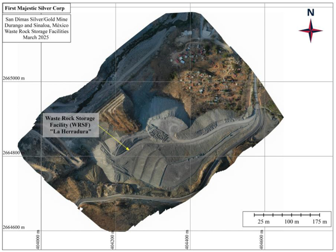
Note: Figure prepared by First Majestic, March 2025.
| 184 | September 2025 |
| San Dimas Silver/Gold Mine Durango and Sinaloa States, Mexico NI-43-101 Technical Report on Mineral Resource and Mineral Reserve Estimates |
|
| 18.4. | Tailings Storage Facilities |
The Cupias Filtered Tailings Storage Facility (FTSF) has a capacity of approximately 4.9 million m3 of filtered tailings, estimated at 8.5 years of additional storage at the current throughput rate, sufficient to support the LOM plan presented in this Technical Report. The Cupias FTSF has four main structures, the Main Dam, which is under progressive closure, the diversion water channel to the South, the intermediate pond (for sedimentation control) and the Eastern Pond (for storm water management). The Cupias FTSF was originally operated as a conventional slurry tailings facility with an embankment raised using upstream construction methodology. In 2007, a tailings filtration plant was commissioned, and the facility was converted into a filtered tailings facility. Since then, filtered tailings have been placed and compacted in the valley downstream of the original tailings dam and act as a buttress to the original TSF.
The Cupias FTSF facility includes a downstream shell toe berm, an underdrain system, surface water diversion channels, two buttressing dikes in the middle of the facility, two permanent ponds and a temporary pond used during rainy season.
The downstream shell toe berm was constructed as homogeneous rockfill structure using the native materials available in the basin upstream of the former slurry tailings dam. The rockfill toe berm, downstream of the starter berm, acts as a foundation for the placement area and allows the crest of the tailings shell to reach a sufficiently high elevation to retain the final general placement area.
The surface rainwater diversion channels include the eastern and western diversion channels, which start near the center line. At this location, the eastern and western channels divert rainwater outside of the Cupias FTSF. The eastern diversion channel routes the water east along the southern boundary of the facility towards a natural channel located south of the Eastern Pond. The natural channel downstream of the eastern diversion channel, is very steep and it discharges water to the Piaxtla River. The western diversion channel routes water west along the southern boundary of the facility past the downstream toe of the tailings dam and ends in a steep drop located 500 m downstream of the main dam. Water from the western diversion channel also discharges to the Piaxtla River. Figure 18-3 shows the Cupias TSF from an aerial view.
| 185 | September 2025 |
| San Dimas Silver/Gold Mine Durango and Sinaloa States, Mexico NI-43-101 Technical Report on Mineral Resource and Mineral Reserve Estimates |
|
Figure 18-3: Filtered Tailings Storage Facility – Overall Plan Site
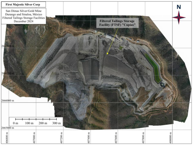
Note: Figure prepared by First Majestic, December 2024.
| 186 | September 2025 |
| San Dimas Silver/Gold Mine Durango and Sinaloa States, Mexico NI-43-101 Technical Report on Mineral Resource and Mineral Reserve Estimates |
|
| 18.5. | Camps and Accommodation |
San Dimas’s infrastructure includes three camps for First Majestic’s staff, security personnel and contractors with an approximate capacity of 500 beds. In addition, there are multiple hotels available in the town of Tayoltita that are commonly used by suppliers and contractors.
| 18.6. | Power and Electrical |
Electrical power is provided by a combination of First Majestic’s own Las Truchas hydroelectric generation system which is interconnected with the CFE supply system, and a new LNG plant consisting of four 1 MW generators which is replacing diesel backup generators in 2025. Since 2015, Las Truchas has been equipped with two generators with a capacity of approximately 28 GWh hours per year based on average rainfall. Figure 18-4 show several images of the Las Truchas Hydroelectric generation plant and dam.
Figure 18-4: Las Truchas Hydroelectric Plant
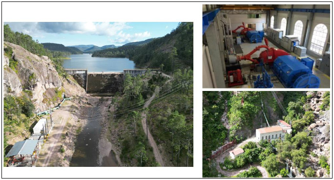
Note: Figure prepared by First Majestic, April 2025.
| 187 | September 2025 |
| San Dimas Silver/Gold Mine Durango and Sinaloa States, Mexico NI-43-101 Technical Report on Mineral Resource and Mineral Reserve Estimates |
|
On average, First Majestic´s hydroelectrical power plant (Figure 18-5) has provided 41% of the yearly requirement in the last three years. The CFE supply has provided 45%, with the remaining 12% being provided by the diesel generators on an ad-hoc basis. These contributions fluctuate throughout the year, mostly based around the rainy seasons when the dam is able to provide more.
Figure 18-5: San Dimas Energy Consumption
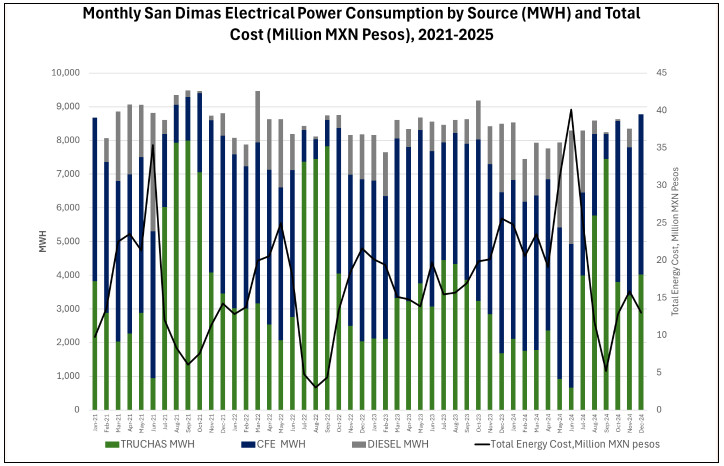
Note: Figure prepared by First Majestic, April 2025.
| 188 | September 2025 |
| San Dimas Silver/Gold Mine Durango and Sinaloa States, Mexico NI-43-101 Technical Report on Mineral Resource and Mineral Reserve Estimates |
|
During the dry season, San Dimas operations are mainly supplied by CFE with approximately 50% of the demand, the remaining is supplied by the hydroelectrical generation plant (34%) and by diesel generation (16%).
In addition, First Majestic is assessing the feasibility of constructing a second water storage dam with a capacity of 18 Mm3, which would feed the Las Truchas dam and increase its power generation capacity to close to 100% of the required demand.
| 18.7. | Communications |
The communication system at San Dimas is interconnected with First Majestic’s data and voice network facilitating communication at the Durango City office and with the corporate offices in Vancouver. This system is based on an antennas network that provides internet services and digital telephone.
Underground mine communications use a leaky feeder very-high-frequency system, which includes a total of 60 km+ of cable installed along tunnels, main ramps, underground refugees, and control points. This system uses a coaxial cable that works as if it were an antenna installed along the tunnels. Radioelectric amplifiers located approximately every 400 m allow the signal to reach the radio receivers of the different users in the mine.
| 18.8. | Water Supply |
The source of water for industrial use comes from mine dewatering stations and from the recycled filtered-tailings water after it has been treated. The balance is sourced from the Santa Rita Mine and other local sources. Currently, about 80% of the water required for processing activities is being treated and recycled.
The company has approved a water sourcing upgrade project aiming to improve system reliability and diversify water sources that is scheduled to commence in 2025.
| 189 | September 2025 |
| San Dimas Silver/Gold Mine Durango and Sinaloa States, Mexico NI-43-101 Technical Report on Mineral Resource and Mineral Reserve Estimates |
|
| 19. | MARKET CONSIDERATION AND CONTRACTS |
The end product from San Dimas comes in the form of silver–gold doré bars. The physical silver–gold doré bars contain approximately 96% silver and 1.3% gold by weight, plus other impurities. Doré bars are delivered to refineries where they are refined to commercially marketable 99.9% pure silver and gold bars.
| 19.1. | Market Considerations |
Silver and gold are considered global and liquid commodities. Silver and gold are predominantly traded on the London Bullion Market Association (LBMA) and COMEX in New York. The LBMA is the global hub of over-the-counter trading in silver and gold and is the main physical market for these metals. ICE Benchmark Administration (IBA) provides the auction platform, methodology, as well as the overall administration and governance for the LBMA. Silver and gold are quoted in US dollars per troy ounce.
| 19.2. | Commodity Price Guidance |
First Majestic has a standard procedure to determine the medium and long-term silver and gold metal price guidance to be used for Mineral Resource and Mineral Reserves estimates. This procedure considers the consensus of future metal price forecasts from various sources including major Canadian and global banks, three-year trailing averages, and metal price forecasts used by peer mining companies in public disclosures. Based on this information, a recommendation for acceptable consensus pricing is put forward by First Majestic’s QP to the company executives, and a decision is made setting the metal price guidance for Mineral Resource and Mineral Reserve estimates. This guidance is updated at least annually, or on an as-required basis.
Metal prices used for the December 31, 2024, Mineral Resource and Mineral Reserve estimates are listed in Table 19-1. When required, foreign exchange rates used in the LOM model were USD:MXN 19.50.
Table 19-1: Metal Prices Used for the December 31, 2024, Mineral Resource
and Mineral Reserve Estimates
| Metal Price |
Units | Resource Estimation |
Reserves Estimation |
|||||||||
| Silver |
$ | /oz Ag | 28.00 | 26.00 | ||||||||
| Gold |
$ | /oz Au | 2,400 | 2,200 | ||||||||
| 19.3. | Product and Sales Contracts |
Silver and gold produced at San Dimas is sold by First Majestic using a small number of international metal brokers who act as intermediaries between First Majestic and the LBMA. First Majestic delivers its gold and silver to a number of refineries, who transfer it to the physical market once refined to commercial
| 190 | September 2025 |
| San Dimas Silver/Gold Mine Durango and Sinaloa States, Mexico NI-43-101 Technical Report on Mineral Resource and Mineral Reserve Estimates |
|
grade. First Majestic transfers risk at the time it delivers its doré from the processing plant to armoured truck services under contract to the refineries. First Majestic normally receives up to 97% of the value of its sales of doré on delivery to the refinery, depending on the timing of sales with the metals broker, with final settlements upon outturn of the refined metals, less processing costs.
Contracts with refining companies as well as metals brokers and traders are tendered periodically and re-negotiated as required. First Majestic continually reviews its cost structures and relationships with refining companies and metal traders to maintain the most competitive pricing possible.
| 19.4. | Streaming Agreement |
First Majestic is party to a purchase (streaming) agreement with Wheaton Precious Metals which entitles Wheaton Precious Metals to receive 25% of the gold equivalent production from the San Dimas mine converted at a fixed exchange ratio of silver to gold at 70 to 1 in exchange for ongoing payments equal to the lesser of $639.91 per ounce (as of December 31, 2024, increasing every May 10th by 1%) and the prevailing market price for each gold equivalent ounce delivered under the agreement. The exchange ratio includes a provision to adjust the gold to silver ratio if the average gold to silver ratio moves above or below 90:1 or 50:1, respectively, for a period of six months. Effective April 30, 2025, the six-month average gold/silver price ratio reached 90:1 and therefore the payable gold equivalent reference to 70 was amended to 90.
| 19.5. | Deleterious Elements |
The San Dimas silver–gold doré bars are very pure, based on past performance and current production projections, and no relevant impurities have been recorded. It is reasonable to expect that the silver–gold doré bars will not carry impurities over the LOM production planned that could be materially penalized at the refineries.
| 19.6. | Supply and Services Contracts |
Contracts and agreements are currently in place for the supply of goods and services necessary for the mining operations. These include, but are not limited to, contracts for diamond drilling services, mine development in waste, waste and ore haulage, maintenance service for the mining equipment, supply of diesel for equipment operation, supply of explosives, supply of power with CFE, supply of process reagents including sodium cyanide, and transportation and logistics services including camp maintenance, catering and personnel transportation.
| 191 | September 2025 |
| San Dimas Silver/Gold Mine Durango and Sinaloa States, Mexico NI-43-101 Technical Report on Mineral Resource and Mineral Reserve Estimates |
|
| 19.7. | Comments on Section 19 |
The doré produced by the mine is readily marketable. Metal prices for Mineral Resource and Reserve estimates are deemed reasonable by the QP based on consensus forecasts and internal analysis. The QP finds service contracts and supply agreements align with Mexican industry standards. Commodity pricing, marketing assumptions, and major contracts are suitable for Mineral Reserve estimates and economic analysis.
| 192 | September 2025 |
| San Dimas Silver/Gold Mine Durango and Sinaloa States, Mexico NI-43-101 Technical Report on Mineral Resource and Mineral Reserve Estimates |
|
| 20. | ENVIRONMENTAL STUDIES, PERMITTING, AND SOCIAL OR COMMUNITY IMPACT |
| 20.1. | Environmental Aspects, Studies and Permits |
In February 2024, San Dimas was distinguished as a Socially Responsible Company (ESR) by the Mexican Center for Philanthropy (CEMEFI) for the thirteenth consecutive year. The ESR award is given to companies operating in Mexico that achieve high performance and commitment to sustainable economic, social, and environmentally positive impact in all corporate life areas, including business ethics, engagement with the community, and preservation of the environment. San Dimas completed the review process successfully by CEMEFI, which included an evaluation of policies, practices, procedures, and management systems to conduct business and community relations sustainably.
20.2. General
First Majestic’s operating practices are governed by the principles set out in its Health and Safety Policy, Environmental Management Policy, Code of Business Conduct and Ethics, and other similar policies related to responsible business and mining. First Majestic’s Board of Directors and Senior Management Team are committed to transparent disclosures of our sustainability management and performance, which included issuing our first biennial sustainability report in 2020, and a subsequent commitment to annual reporting beginning in early 2024.
| 20.3. | Environmental Compliance in Mexico |
Mining in Mexico is primarily regulated by Federal laws, though some areas require state or local approval. The principal agency promulgating environmental standards and regulating environmental matters in Mexico is Ministry of Environment and Natural Resources (SEMARNAT). There are Federal delegations and state agencies of SEMARNAT.
An Environmental Impact Manifestation (MIA) must be prepared for submittal to SEMARNAT before applying for a license for a mining operation. The MIA must include an analysis of local climate, air quality, water, soil, vegetation, wildlife, and cultural resources in the San Dimas property, as well as a socioeconomic impact assessment. The Unique Environmental License (LAU) is based on an approved MIA and is required before the start of an industrial operation.
A permit must also be obtained from SEMERNAT for Risk Analysis (RA). A study must be conducted to identify and assess the potential environmental releases and risks, and to develop a plan to prevent and mitigate risks, and to respond to potential environmental emergencies. A strong emphasis is placed on the storage and handling of hazardous materials such as chemical reagents, fuel, and tailings.
The Federal Attorney for Environmental Protection (PROFEPA) is the body responsible for enforcement, public participation, and environmental education. After receiving an operation license, an agreement is
| 193 | September 2025 |
| San Dimas Silver/Gold Mine Durango and Sinaloa States, Mexico NI-43-101 Technical Report on Mineral Resource and Mineral Reserve Estimates |
|
setup between the operating company and the PROFEPA in order to follow-up on obligations, commitments, and monitoring of preventive activities.
A division of SEMARNAT, the National Water Commission (CONAGUA) is the authority for all water-related matters including activities that may impact surface water supply or quality, such as water use permits and fees, diversion of surface waters, constructions in significant drainages, or water discharge.
In Mexico, all land has a designated use. The majority of the land covering the San Dimas concessions is designated as agricultural or forest land. A Change of Land Use (CUS) permit is required for all production areas, and for potential areas of expanded production. The CUS study is based on federal forestry laws and regulations and requires an in-depth analysis of the current land use , the native flora and fauna, and an evaluation of the current and proposed uses of the land, and their impact on the environment. The study requires that agreements exist with all affected surface rights holders, and that an acceptable reclamation and restoration plan is in place. Mexican regulations require that the National Institute of Anthropology and History (INAH) reviews project plans prior to construction and inspects the project area for historical and archeological resources.
| 20.4. | Existing Environmental Conditions |
San Dimas is a mine with a long production history. Mining activity dates back to the 18th century and since that time several enterprises have operated in the area. As such, the vicinity had been affected by mining industrial activity before First Majestic began operations in 2018, including: vacant surface mine infrastructure in the form of old mining camps, historic waste dumps, areas of surface subsidence above historically mined areas, and low-grade mineralized stockpiles.
Environmental liabilities for the current operation are typical of those associated with an operating underground precious metals mine, including the future closure and reclamation of mine portals and ventilation infrastructure, access roads, processing facilities, power lines, low-grade TMFs, and all surface infrastructure that supports the operations.
| 20.5. | Environmental Studies, Permits and Issues |
Environmental and social studies are routinely performed in San Dimas to characterize existing conditions and to support the preparation of Risk Assessments and Accident Prevention Programs for the operation and are documented as part of the EMS.
| 20.5.1. | Surface Hydrology |
Table 20-1 summarizes relevant surface hydrological studies completed.
| 194 | September 2025 |
| San Dimas Silver/Gold Mine Durango and Sinaloa States, Mexico NI-43-101 Technical Report on Mineral Resource and Mineral Reserve Estimates |
|
Table 20-1: Summary of Surface Hydrology Studies
| Study Name | Date | Company | Study Scope | Main Results | ||||
|
Hydrologic Analysis and Sedimentation Ponds Design for the Cupias FTSF |
Sept 2023 | WSP | Hydrologic analysis and the water management update to support the infrastructure design of the sedimentation pond and the East Contact Water Pond located within the Cupias Tailings Storage Facility (FTSF) area. |
The data base was updated for the hydrological design inputs and the surface water management design in FTSF “Cupias” |
| 20.5.2. | Surface Water Geochemistry |
Surface water geochemistry studies are carried out regularly with samples sent to an independent laboratory as required by the Mexican regulation. Results of these studies have shown that the monitoring parameters are in compliance (Table 20-2).
Table 20-2: Summary of Surface Water Studies
| Study Name | Date | Company | Study Scope | Main Results | ||||
|
Surface water quality |
Annual | ALS | Physical, chemical, and biological parameters. |
Results are below the maximum limits permitted by the Mexican regulation: NOM-001-SEMARNAT-1994. |
| 20.5.3. | Hydrogeology |
Mining operations in San Dimas are located in the mountain range north and south of the Piaxtla River and are currently operating above the water table. Consequently, no hydrogeological studies have been conducted in the area to date.
| 20.5.4. | Soil |
Soil studies are in progress. Results of these studies will be incorporated into the updated site remediation/reclamation plan. The studies are provided in Table 20-3.
Table 20-3: Summary of Soil Sampling Studies
| Study Name | Date | Company | Study Scope | Main Results | ||||
| Tailings and Waste Rock Characterization | Annual | ALS Lab | Soil Sampling | The results are within the maximum limits permitted by the Mexican regulation: NOM-141-SEMARNAT-2003 and NOM-157-SEMARNAT-2009. |
| 20.5.5. | Air Quality |
Air quality study results are provided in Table 20-4.
| 195 | September 2025 |
| San Dimas Silver/Gold Mine Durango and Sinaloa States, Mexico NI-43-101 Technical Report on Mineral Resource and Mineral Reserve Estimates |
|
Table 20-4: Air Quality Studies
| Study Name | Frequency | Company | Study Scope | Main Results | ||||
| Perimeter particle study | Annual | GAMATEK | Particle perimeter monitoring: around process plant and tailings dam. | Results are within the maximum limits permitted by the Mexican regulation: NOM-025-SSA1-1993. | ||||
| Emissions from fixed sources | Annual | GAMATEK | Monitoring of fixed sources (smelter, crusher and laboratory) to determine total particles and combustion gases | No impacts on operations or mine plans were identified. | ||||
20.5.6. Noise
Table 20-5 summarizes the noise impact studies completed to date.
Table 20-5: Noise Impact Studies
| Study Name | Date | Company | Study Scope | Main Results | ||||
| Perimeter noise study | Annual | GAMATEK | Perimeter noise monitoring: access control gate, several access points in the town of Tayoltita, access road to the tailings deposit, tailings dams 1 and 2, process plant, and main access road. | The results are within the maximum limits permitted by the Mexican regulation: NOM-081-SEMARNAT-1994. | ||||
20.5.7. Flora and Fauna
General details of the completed flora and fauna surveys are provided in Table 20-6.
Table 20-6: Flora and Fauna Studies
| Study Name | Date | Company | Study Scope | Main Results | ||||
| Aquatic life inventory | Annual (since 2012) |
Consultoria y Tecnología Ambiental |
Compile an inventory of aquatic life through Piaxtla river. | No damage to aquatic species has been identified as a consequence of the operation of the mine. | ||||
20.5.8. Social and Cultural Baseline Studies
General details of the social survey carried out in Tayoltita are provided in Table 20-7.
| 196 | September 2025 |
| San Dimas Silver/Gold Mine Durango and Sinaloa States, Mexico NI-43-101 Technical Report on Mineral Resource and Mineral Reserve Estimates |
|
Table 20-7.
| 197 | September 2025 |
| San Dimas Silver/Gold Mine Durango and Sinaloa States, Mexico NI-43-101 Technical Report on Mineral Resource and Mineral Reserve Estimates |
|
Table 20-7: Summary of Social Studies
| Study Name | Date | Company | Study Scope | Main Results | ||||
| Community Diagnostics Study | July 2015 | Almeda Consultores | Assess the economic, social, and cultural conditions of the inhabitants of the town of Tayoltita. | Provided a baseline of areas of interest or concerns of the community related to the activities and support that the company could offer to the community. | ||||
| Community Concerns Survey | Q4 2022 | First Majestic Silver CSR Department | Engage directly with community members around San Dimas to determine key topics of concern for the community, as well as relative priority of these topics. | Gained understanding of the communities topics of interest and concerns, and how these have evolved since the baseline study. Results to assist in prioritization of community investment and enrichment projects. | ||||
| 20.5.9. | Historical and Cultural Aspects |
No historical or cultural studies have recently been conducted in the area.
| 20.6. | Tailings Handling and Disposal |
Currently, tailings handling and disposal are undertaken per the applicable Mexican regulations and aligned with the guidance of the Canadian Dam Association (CDA) and Mining Association of Canada (MAC). Annual geochemical tailings characterization studies indicate that the tailings to date are not potentially acid generating (PAG), nor will they result in metals leaching (ML).
WSP periodically conducts stability analyses as an external review; the most recent of which was executed in 2023, and the results were positive with safety indices complying to CDA recommendations. These analyses are periodically reviewed by the in-house geotechnical team specializing in mining waste. The independent consultant is scheduled to conduct an annual site visit during the rainy season. The goal of the visit is to assess stability conditions and inspect the implementation of standard operating procedures. The consultant prepares a dam safety inspection report including recommendations and improvement opportunities.
The last report inspection was delivered in July 2024, from which four items were identified that required attention:
| a) | Complete the dam break analysis to designate its final classification per potential consequences according to CDA and GISTM. At the closing of this Technical Report, a rheological characterization campaign of the “Cupias” FTSF tailings was completed, which will be the basis of said analysis. |
| b) | Eliminate the discharge of solution into the old Cupías reservoir and redirect it to the new Intermediate pool designed and constructed to control sedimentation. |
| c) | Remove sediments from the eastern pool and conform its geometry according to the final design with enough capacity for a 1000-year storm event. |
| d) | Stabilize the buttress allocated in the middle of the facility. |
| 198 | September 2025 |
| San Dimas Silver/Gold Mine Durango and Sinaloa States, Mexico NI-43-101 Technical Report on Mineral Resource and Mineral Reserve Estimates |
|
At the Technical Report effective date, the activities b) and c) have been addressed and solved, a) and d) are in progress.
Cupias Tailings Storage Facility operation complies with Mexico regulations for this type of infrastructure. The company is advancing detailed engineering and environmental studies for a TSF expansion to be permitted at completion.
| 20.7. | Waste Material Handling and Disposal |
Currently in San Dimas there are 17 Waste Rock Storage Facilities (WRSF’s), 16 of which are not operating. These include Noche Buena, La Verdosa 2 and 3, Castellana, As de Oros, San Francisco, Santa María, Promontorio 1, 2 and 3, San Luis, Graben, Queleles and Santa Rita 1-4, 5 and 6. The operating facility is La Herradura. Not all WRSFs are covered by authorizations or Environmental Impact Assessments (EIAs), as some of the facilities pre-date First Majestic’s control of the underlying concessions and surface lands or were constructed by previous operators.
Annual waste rock characterization studies are undertaken to determine PAG and ML potential, as shown in Table 20-8.
Table 20-8: Tailings and Waste Rock Studies
| Study Name | Date | Company | Study Scope | Main Results | ||||
| Tailings and Waste Rock Characterization | Annual | ALS Lab | Potential acid generation and Metal leaching. | The results are within the maximum limits permitted by the Mexican regulation: NOM-141-SEMARNAT-2003 and NOM-157-SEMARNAT-2009. | ||||
| 20.8. | Mine Effluent Management |
San Dimas generates mine-dewatering effluents from some of the mines, which is measured, recorded, and notified to the National Water Commission (CONAGUA) every quarter and the corresponding water usage rates are paid. Registration for the use and transfer of surplus groundwater with the CONAGUA is still to be obtained.
| 20.9. | Process Water Management |
All process water is recycled in a closed circuit, so there are no process water discharges. The make-up water required in the processing plant is obtained from several sources. Water consumption is measured, recorded, and notified to CONAGUA quarterly and the corresponding water usage rates are paid.
| 199 | September 2025 |
| San Dimas Silver/Gold Mine Durango and Sinaloa States, Mexico NI-43-101 Technical Report on Mineral Resource and Mineral Reserve Estimates |
|
| 20.10. | Hazardous Waste Management |
The management of hazardous waste within the San Dimas operations is carried out in accordance with the provisions of the applicable Mexican official standards. First Majestic is registered with SEMARNAT for waste management and waste handling. San Dimas has adequate handling, labeling and temporary storage protocols in place to meet the Mexican regulations requirements. First Majestic contracts companies authorized by SEMARNAT for waste transportation and final disposal.
| 20.11. | Monitoring |
Table 20-9 summarizes monitoring activities currently undertaken.
Table 20-9: Environmental Monitoring Activities
| Element | Frequency | Monitoring Activities | ||
| Water | Quarterly | Monitoring of surface, underground, drinking, contact and wastewater, by a certified independent laboratory. | ||
| Air | Annual | Monitoring of fixed emissions sources (smelter, crusher, and laboratory) to determine total particles and combustion gases emissions. Perimeter particle monitoring - around the process plant and tailings dam area |
||
| Waste rock and tailings | Annual | Characterization of tailings and waste rock in terms of PAG and ML. Evidence from periodic monitoring shows that the waste rock and tailings is not PAG and will not cause ML. |
||
| Perimeter noise | Annual | Perimeter noise monitoring, around the process plant and tailings deposit area. |
| 20.12. | Environmental Obligations |
The following is a description of the principal obligations relating to environmental matters for San Dimas.
| • | Yearly operation licence (COA): Report presented annually containing environmental information on the operation of the mine, including water, air, waste discharge, materials, and production; |
| • | Dangerous waste declaration: Official document that controls the operation of dangerous waste from the mining installation to the site where it will be disposed (final disposal site); |
| • | Quarterly payment for water use; |
| • | Quarterly payment for water disposal; |
| • | Bimonthly payment for federal occupation; and |
| • | Monitoring plan for water, air, waste, and noise: These are carried out at various times in accordance with regulatory requirements. |
| 200 | September 2025 |
| San Dimas Silver/Gold Mine Durango and Sinaloa States, Mexico NI-43-101 Technical Report on Mineral Resource and Mineral Reserve Estimates |
|
20.13. Permits
The main environmental permit is the environmental license “Licencia Ambiental Unica” (LAU) under which the mine operates its industrial facilities in accordance with the Mexican environmental protection laws administered by SEMARNAT as the agency in charge of environment and natural resources.
The most recent update to the main environmental permit was approved in April 2024.
Other significant permits are those related to water, one for water supply rights, and another for water discharge rights.
San Dimas is an operating mine, as such it holds the major environmental permits and licenses required by the Mexican authorities to carry out mineral extracting activities in the mining complex.
| 201 | September 2025 |
| San Dimas Silver/Gold Mine Durango and Sinaloa States, Mexico NI-43-101 Technical Report on Mineral Resource and Mineral Reserve Estimates |
|
Table 20-10 contains a list of the major permits issued to San Dimas. Permits that are in process are listed in Table 20-11.
On May 8, 2023, the Mexican Government enacted a decree amending several provisions of the Mining Law, the Law on National Waters, the Law on Ecological Equilibrium and Environmental Protection and the General Law for the Prevention and Integral Management of Waste (the “Decree”), which became effective on May 9, 2023. The Decree amends the mining and water laws, including: (i) the duration of the mining concession titles, (ii) the process to obtain new mining concessions (through a public tender), (iii) imposing conditions on water use and availability for the mining concessions, (iv) the elimination of “free land and first applicant” scheme; (iv) new social and environmental requirements in order to obtain and keep mining concessions, (v) the authorization by the Mexican Ministry of Economy of any mining concession’s transfer, (vi) new penalties and cancellation of mining concessions grounds due to non-compliance with the applicable laws, (vii) the automatic dismissal of any application for new concessions, and (viii) new financial instruments or collaterals that should be provided to guarantee the preventive, mitigation and compensation plans resulting from the social impact assessments, among other amendments. Additionally, on March 18, 2025, the new legislative framework for the hydrocarbon sector in Mexico was published in the Federal Official Gazette. This framework introduces specific permitting requirements for various hydrocarbons, including diesel.
These amendments are expected to have an impact on our current and future exploration activities and operations in Mexico, and the extent of such impact is yet to be determined but could be material for the Company. On June 7, 2023, the Senators of the opposition parties (PRI, PAN, and PRD) filed a constitutional action against the Decree, which is pending to be decided by Plenary of the Supreme Court of Justice.
During the second quarter of 2023, the Company filed various amparo lawsuits, challenging the constitutionality of the Decree. As of the date of this Technical Report, these amparos filed by First Majestic, along with numerous amparos in relation to the Decree that have been filed by other companies, are still pending before the District or Collegiate Courts. On July 15, 2024, the Supreme Court of Justice in Mexico suspended all ongoing amparo lawsuits against the Decree whilst the aforementioned constitutional action is being considered by the Supreme Court. As of the date of this Technical Report, the Supreme Court has not yet rendered an official ruling on the constitutional action against the Decree that was brought by the opposition parties within the Mexican government.
Certain revisions were made in 2023 to Mexican laws affecting the mining sector. This TRS reflects the Company’s understanding of the laws that affect the Company in light of these revisions. It should be noted that the current and revised laws are subject to ongoing interpretation and that in many instances the revised laws require implementing regulations, which have not yet been promulgated, for their impact to be fully assessed
| 202 | September 2025 |
| San Dimas Silver/Gold Mine Durango and Sinaloa States, Mexico NI-43-101 Technical Report on Mineral Resource and Mineral Reserve Estimates |
|
Table 20-10: Major Permits Issued
| Permit | Date Granted | Document No. | Status |
Expiration Date |
||||
| Environmental License (LAU) | 04-03-2024 | LAU-10/042-2011 | Current | Unlimited | ||||
| Water Rights Concession | 14-03-2011 | 03DGO101536/10EADL11 | Current | 30-11-2044 | ||||
| Colony Central | ||||||||
| Water Rights Concession | 14-03-2011 | 03DGO102180/11IDDL11 | Current | 14-03-2035 | ||||
| Mala Noche 2011 | ||||||||
| Water Rights Concession | 14-03-2011 | 03DGO101534/10JADL11 | Current | 23-07-2026 | ||||
| Truchas 2011 | ||||||||
| Federal Land Use Concession | 16-03-2011 | 03DGO101220/10FADL11 | Current | 22-12-2019 | ||||
| Puente Madera | ||||||||
| Federal Land Use Concession | 08-08-2019 | 813175 | Current | 08-08-2049 | ||||
| Puente San Luis 2019 | ||||||||
| Federal Land Use Concession | 16-03-2011 | 03DGO117421/10EADL11 | Current | 08-02-2050 | ||||
| Servicios 1 | ||||||||
| Federal Land Use Concession | 16-03-2011 | 03DGO117422/10EADL11 | Current | 08-02-2050 | ||||
| Servicios 2 | ||||||||
| Federal Land Use Concession | 12-06-2012 | 03DGO150098/10EADA12 | Current | 12-06-2042 | ||||
| La Herradura Waste Dump | ||||||||
| Federal Land Use Concession | 16-03-2011 | 03DGO118864/10JADL11 | Current | 14-05-2030 | ||||
| Truchas 2011 | ||||||||
| Environmental Impact Assessment Permiter Fence | 15-05-2018 | SG/130.2.1.1/0896/18 | Current | Unlimited | ||||
| Environmental Impact Assessment San Luis Bridge | 15-05-2018 | SG/130.2.1.1/0897/18 | Current | Unlimited | ||||
| Environmental Impact Assessment Exploration Mala Noche II | 16-07-2020 | SG/130.2.1.1/0820/20 | Current | 16-07-2025 | ||||
| Environmental Impact Assessment | 04-10-2019 | SG/130.2.1.1/2406/19 | Current | 04-10-2040 | ||||
| Piaxtla River Aggregates | ||||||||
| Environmental Impact Assessment | 10-05-2012 | SG/130.2.1.1/001099/12 | Current | 10-11-2031 | ||||
| La Herradura Waste Dump | ||||||||
| Water Discharge - San Dimas | 12-07-2011 | 03DGO101668/10EADL11 | Current | 08-05-2045 | ||||
| Mining Hazardous Materials Handling Plan - San Dimas 2018 | 23-08-2018 | 10-PPM-I-0183-2018 | Current | 23-08-2035 | ||||
| Hazardous Materials Handling Plan - San Dimas 2016 | 08-02-2016 | 10-PMG-I-1931-2016 | Current | Unlimited | ||||
| Accident Prevention Plan (PPA) - San Dimas 2016 | 10-03-2016 | DGGIMAR.710/002404 | Current | Unlimited | ||||
| Register Environmental Handling Unit (UMA) - Las Truchas 2011 | 28-10-2011 | SEMARNAT-UMA-EX-0374-DGO | Current | Unlimited |
| 203 | September 2025 |
| San Dimas Silver/Gold Mine Durango and Sinaloa States, Mexico NI-43-101 Technical Report on Mineral Resource and Mineral Reserve Estimates |
|
Table 20-11: Permits in Process
| Permit | Date Granted | Document No. | Status | Expiration Date | ||||
| Water Rights Concession - Puente Madera | 16-03-2011 | 03DGO101220/10FADL11 | Update in progress | 06-09-2045 | ||||
| Special Hazardous Materials Handling Plan - San Dimas Renewal 2024 | 06-09-2024 | SRNyMA.SMA.047.24 | Update in progress | 31-12-2025 |
20.14. Closure Plan
The closure plan is intended to comply with policies and terms included in the obligations denominated as Asset Retirement Obligations (ARO), in particular those related to the works and activities to be carried out in closure preparation and post-closure. The San Dimas closure plan includes the following concepts: post-operation activities, closure of facilities, reclamation of certain areas, monitoring, and site abandonment.
One of the purposes of the plan is to quantify the budget required to support and complete the closing works and mitigation activities relevant to soil quality, surface water, groundwater, and wildlife in the area of influence of the infrastructure used for the mining and processing activities.
First Majestic records a decommissioning liability for the estimated reclamation and closure of the Property, including site rehabilitation and long-term treatment and monitoring costs, discounted to net present value (NPV).
The NPV is determined using the liability-specific risk-free interest rate. The estimated NPV of reclamation and closure cost obligations is remeasured on an annual basis or when changes in circumstances occur and/or new material information becomes available. Increases or decreases to the obligations arise due to changes in legal or regulatory requirements, the extent of environmental remediation required, cost estimates and the discount rate applied to the obligation. The NPV of the estimated cost of these changes is recorded in the period in which the change is identified and quantifiable. Reclamation and closure cost obligations relating to operating mine and development projects are recorded with a corresponding increase to the carrying amounts of related assets.
San Dimas is subject to a full closure plan and reclamation of the site upon cessation of operations, which would involve all facilities currently being used (mill, hydro-electric power plant, mines, surface infrastructure, power lines, roads, dry tailings). First Majestic has accrued a decommissioning liability consisting of reclamation and closure costs for San Dimas. The undiscounted cash flow amount of the obligation was US$13.23 million on December 31, 2024.
The estimation of restoration and closing costs was carried out using the Standardized Reclamation Cost Estimator (SRCE) model. The SRCE model contains best practices for estimating the remediation and restoration costs of areas impacted by industrial processes. First Majestic adapted the model to reflect current regulations in Mexico, and estimates were escalated for inflation.
| 204 | September 2025 |
| San Dimas Silver/Gold Mine Durango and Sinaloa States, Mexico NI-43-101 Technical Report on Mineral Resource and Mineral Reserve Estimates |
|
First Majestic is currently dealing with two historical environmental liabilities: reclamation of the old San Antonio milling facilities (Contraestaca) and closure and reclamation of the old San Antonio tailings facilities. Reclamation work of these areas is scheduled in line with the closure plan.
| 20.15. | Corporate Social Responsibility |
First Majestic maintains a close relationship with the local government and inhabitants of Tayoltita and surrounding communities through the Corporate Social Responsibility (CSR) department which has established a system for risk management to monitor and address any relevant impact the operation may have on the community. As a result of First Majestic’s efforts to date, the social operating license with the local communities has been maintained and strengthened.
In 2018 and through 2019 First Majestic completed an internal assessment of materiality in sustainable development reporting for San Dimas. The assessment reviewed the potential issues of highest impact or importance to First Majestic’s stakeholders and prioritized those considering internal and external perspectives. Workplace health and safety, labour relations, land access, regulatory compliance and water management were identified as issues with the highest impact on San Dimas over the next several years. The process considers all issues identified in the assessment and will broaden to include external verification with employees and other stakeholder groups.
First Majestic, through its ownership of Primero Empresa, supports community education and provides a 50% tuition subsidy to all students who attend the school in Tayoltita. In 2019, 220 students were enrolled at the school. First Majestic continues to work closely with the College of Professional Technical Education (CONALEP) campus in Tayoltita where students participate in classroom activities as well as direct practical experience in San Dimas laboratories and workshops. Over the 13 years since the program started, approximately 40% of the 350 graduates have been employees of San Dimas. In 2013 The Mexican Ministries of Education and Labor recognized Primero Empresa’s ongoing support to this program with a first-place distinction for practices in education and employment at the College.
| 20.15.1. | Ejidos |
An Ejido is a form of communal ownership of land recognized by Mexican federal laws. Following the Mexican Revolution, beginning in 1934 as a key component of agrarian land reform, the Ejido system was introduced to distribute parcels of land to groups of farmers known as Ejidos. While mineral rights are administered by the federal government through federally issued mining concessions, in many cases, an Ejido may control surface rights over communal property. An Ejido may sell or lease lands directly to a private entity, and it may allow individual members of the Ejido to obtain title to specific parcels of land and thus the right to rent, distribute, or sell the land. Three of the properties at San Dimas for which First Majestic holds legal title are subject to legal proceedings commenced by Ejidos asserting title to the property. None of the proceedings name First Majestic or its subsidiaries as a party and First Majestic therefore has no standing to participate in the proceedings. In all cases, the defendants are previous
| 205 | September 2025 |
| San Dimas Silver/Gold Mine Durango and Sinaloa States, Mexico NI-43-101 Technical Report on Mineral Resource and Mineral Reserve Estimates |
|
owners of the properties, either deceased individuals who, according to certain public deeds, owned the properties more than 80 years ago, corporate entities that are no longer in existence, or Goldcorp. The proceedings also name the Tayoltita Property Public Registry as co-defendant.
In 2015, First Majestic obtained a favourable decision in a constitutional lawsuit filed by the Company against the Ejido Guamuchil. This proceeding, the Guamuchil Suit, was then reinstated resulting in the First Majestic’s subsidiaries gaining standing rights as an affected third party permitted to submit evidence of the Company’s legal title on the disputed land. In December 2018, First Majestic received a favourable decision in the civil lawsuit filed by the Ejido, stating that the Ejido did not prove legal ownership of the disputed land. Against such decision, the Ejido filed an appeal, and First Majestic received a favourable decision in such appeal on May 2019.
On March 26, 2021, First Majestic obtained a final favourable decision in a constitutional lawsuit filed by the Ejido against the appeal, confirming its legal ownership of the land, so the case was concluded. First Majestic is also pursuing the annulment of a decision obtained by Ejido Guarisamey in a land claim, which is currently pending to be decided by the Mexican Courts.
If First Majestic is not successful in this challenge, San Dimas could face higher costs associated with agreed or mandated payments that would be payable to Ejido Guarisamey for the use of the disputed land.
| 206 | September 2025 |
| San Dimas Silver/Gold Mine Durango and Sinaloa States, Mexico NI-43-101 Technical Report on Mineral Resource and Mineral Reserve Estimates |
|
| 21. | CAPITAL AND OPERATING COST |
| 21.1. | Capital Costs |
San Dimas has been under First Majestic operation since May 10, 2018. The sustaining capital expenditures are budgeted on an as-required basis, established on actual conditions at the mine and the processing plant infrastructure. The LOM plan includes estimates for sustaining capital expenditures for the mining and processing activities required.
Sustaining capital expenditures will mostly be allocated for on-going development, infill drilling, mine equipment rebuilding, major overhauls or replacements, plant maintenance, on-going plant refurbishing, and tailings facilities expansion as needed.
Estimated sustaining capital expenditures for the LOM plan are assumed to average $20 million per annum. The amount of exploration conducted to find new targets, with the objective of replacing and/or expanding the Mineral Resources will be dependent on the success of exploration and diamond drilling programs. Due uncertainty inherent in the exploration process, potential new sources of mineralization are not included in the LOM plan. Sustaining capital is focused on maintaining current operational capacities of the plant and equipment, while expansionary capital is focussed on expanding new sources of mineralization. Table 21-1 presents the summary of sustaining expenditures estimated for San Dimas.
Table 21-1: San Dimas Mining Sustaining Capital Costs Summary
| Type |
Total | 2025 | 2026 | 2027 | 2028 | 2029 | ||||||||||||||||||
| Mine Development |
$ | 53.5 | $ | 12.3 | $ | 12.3 | $ | 12.3 | $ | 13.4 | $ | 3.1 | ||||||||||||
| Property, Plan & Equipment |
$ | 26.8 | $ | 5.2 | $ | 5.2 | $ | 5.2 | $ | 5.2 | $ | 5.9 | ||||||||||||
| Other Sustaining Cost |
$ | 5.7 | $ | 1.1 | $ | 1.1 | $ | 1.1 | $ | 1.1 | $ | 1.2 | ||||||||||||
| Total Sustaining Capital Costs |
$ | 86.0 | $ | 18.6 | $ | 18.7 | $ | 18.7 | $ | 19.8 | $ | 10.2 | ||||||||||||
| Near Mine Exploration |
$ | 4.5 | $ | 1.2 | $ | 1.1 | $ | 1.1 | $ | 1.0 | ||||||||||||||
|
|
|
|
|
|
|
|
|
|
|
|
|
|||||||||||||
| Total Capital Costs |
$ | 90.5 | $ | 19.8 | $ | 19.8 | $ | 19.8 | $ | 20.8 | $ | 10.2 | ||||||||||||
|
|
|
|
|
|
|
|
|
|
|
|
|
|||||||||||||
| 21.2. | Operating Costs |
San Dimas has a well-established cost management system and a good understanding of the costs of operation. Although the cost inputs are based on site actuals and contractor quotes, there will be variances from the estimates used for this Technical Report and the actual costs. The majority of costs are priced in Mexican pesos and converted to US dollars for the purposes of this Technical Report (e.g., labour, various supplies, etc.). Based on current operating experience at San Dimas, the total cost of mining is estimated to be ±15%, which is considered to be a sufficient level of detail to support the declaration of Mineral Reserves.
| 207 | September 2025 |
| San Dimas Silver/Gold Mine Durango and Sinaloa States, Mexico NI-43-101 Technical Report on Mineral Resource and Mineral Reserve Estimates |
|
A summary of the San Dimas operating costs resulting from the LOM plan and the cost model used for assessing economic viability is presented in Table 21-2. A summary of the annual operating expense is presented in Table 21-3.
Table 21-2: San Dimas Operating Costs Used in the LOM Plan
| Type |
$/tonne milled |
|||
| Mining Cost |
$ | 64.9 | ||
| Processing Cost |
$ | 38.5 | ||
| Indirect Costs |
$ | 57.1 | ||
| Total Production Cost |
$ | 160.5 | ||
| Selling Costs |
$ | 2.6 | ||
|
|
|
|||
| Total Cash Cost |
$ | 163.0 | ||
|
|
|
|||
Table 21-3: San Dimas Annual Operating Costs
| Type |
Total | 2025 | 2026 | 2027 | 2028 | 2029 | ||||||||||||||||||
| Mining Cost |
$ | 209.6 | $ | 40.8 | $ | 41.0 | $ | 41.0 | $ | 40.9 | $ | 46.0 | ||||||||||||
| Processing Cost |
$ | 124.3 | $ | 24.2 | $ | 24.3 | $ | 24.3 | $ | 24.2 | $ | 27.3 | ||||||||||||
| Indirect Costs |
$ | 184.3 | $ | 35.9 | $ | 36.0 | $ | 36.0 | $ | 35.9 | $ | 40.4 | ||||||||||||
| Total Production Cost |
$ | 518.1 | $ | 101.0 | $ | 101.2 | $ | 101.2 | $ | 101.0 | $ | 113.7 | ||||||||||||
| Selling Costs |
$ | 8.3 | $ | 1.6 | $ | 1.6 | $ | 1.6 | $ | 1.6 | $ | 1.8 | ||||||||||||
|
|
|
|
|
|
|
|
|
|
|
|
|
|||||||||||||
| Total Cash Cost |
$ | 526.5 | $ | 102.6 | $ | 102.9 | $ | 102.9 | $ | 102.6 | $ | 115.5 | ||||||||||||
|
|
|
|
|
|
|
|
|
|
|
|
|
|||||||||||||
| 208 | September 2025 |
| San Dimas Silver/Gold Mine Durango and Sinaloa States, Mexico NI-43-101 Technical Report on Mineral Resource and Mineral Reserve Estimates |
|
| 22. | ECONOMIC ANALYSIS |
First Majestic is using the provision for producing issuers whereby producing issuers may exclude the information required under Item 22 for technical reports on properties currently in production and where no material production expansion is planned.
Mineral Reserve declaration is supported by a positive cashflow.
| 23. | ADJACENT PROPERTIES |
This section is not relevant to this Technical Report.
| 24. | OTHER RELEVANT DATA AND INFORMATION |
This section is not relevant to this Technical Report.
| 209 | September 2025 |
| San Dimas Silver/Gold Mine Durango and Sinaloa States, Mexico NI-43-101 Technical Report on Mineral Resource and Mineral Reserve Estimates |
|
| 25. | INTERPRETATION AND CONCLUSIONS |
The following interpretations and conclusions are a summary of the QPs’ opinions based on the information presented in this Technical Report.
| 25.1. | Mineral Tenure, Surface Rights and Agreements |
Information provided by First Majestic technical and legal experts supports that the mining tenure held is valid and is sufficient to support declaration of Mineral Resources and Mineral Reserves; San Dimas has adequate mineral concessions and surface rights to support mining operations over the planned underground LOM presented in this Technical Report.
Primero Empresa has agreements with the Ejidos and some of these agreements may be subject to renegotiation from time to time. Material changes to the existing agreements may have a significant impact on operations at San Dimas. If First Majestic is not able to reach an agreement for the use of the land with the Ejidos, then First Majestic may be required to modify its operations or plans for the exploration and development of its mines.
| 25.2. | Geology and Mineralization |
The current understanding of mineralization and alteration styles, as well as the structural and lithological controls on mineralization in the San Dimas district, is sufficient to support the Mineral Resource and Mineral Reserve estimations.
San Dimas mineral deposits are examples of silver and gold bearing epithermal quartz veins that formed in a low-sulphidation setting.
| 25.3. | Exploration and Drilling |
The exploration programs completed to date are appropriate for San Dimas’s mineralization style. Sampling methods (diamond drill hole and channel sampling) and data collection are acceptable given San Dimas’ deposit dimensions, mineralization true widths, and the style of the deposits. The programs are reflective of industry-standard practice and can be used in support of Mineral Resource and Mineral Reserve estimation.
| 25.4. | Data Analysis |
Collar, downhole survey, lithology, core recovery, specific gravity and assay data collected are considered suitable to support Mineral Resource estimation. Sample preparation, analysis, and quality-control measures meet current industry standards and provide reliable gold and silver results.
| 210 | September 2025 |
| San Dimas Silver/Gold Mine Durango and Sinaloa States, Mexico NI-43-101 Technical Report on Mineral Resource and Mineral Reserve Estimates |
|
25.5. Metallurgical Testwork
The metallurgical analysis presented in this Technical Report is primarily based on historical plant operational data, mineralogical investigations, and performance monitoring tests conducted by the on-site Metallurgical Laboratory. The tests carried out by the on-site Metallurgical Laboratory demonstrate a high level of repeatability when compared to actual plant performance.
The maturity of the processing operation, established practices in metallurgical monitoring and investigations, and a strong understanding of future ores support the metallurgical recoveries outlined in the LOM plan and the economic analysis that underpins the Mineral Reserves. These recoveries have been assumed to be 92.6% for silver and 95.6% for gold. However, if future ores deviate significantly from the historical ore characteristics, there is a risk that recovery levels may not fully align with these projections.
| 25.6. | Mineral Resource Estimates |
The Mineral Resources for San Dimas were estimated according to industry best practices and were reported using the 2014 CIM Definition Standards. The estimates are based on the current database of exploration drill holes and production channel samples, the geological mapping of underground development, the geologic interpretation and models, as well as the surface topography and underground mining development wireframes. The Mineral Resources were classified into the Measured, Indicated, or Inferred categories based on: the confidence in the geological interpretation and models; confidence in the continuity of metal grades; the sample support for the estimation and reliability of the sample data; and reliable production channel samples with detailed geological control. The Mineral Resource estimates are a reasonable representation of the mineralization found at San Dimas with the current level of sampling.
Factors that may materially impact the Mineral Resource estimates include: changes to the assumptions used to generate the silver-equivalent grade cut-off grade including metal price and exchange rates; changes to interpretations of mineralization geometry and continuity; changes to geotechnical, mining method, and metallurgical recovery assumptions; assumptions as to the continued ability to access the site, retain mineral and surface rights titles, maintain environment and other regulatory permits, and maintain the social license to operate.
| 25.7. | Mineral Reserve Estimates |
The Mineral Reserves estimates for San Dimas include considerations for the underground mining methods in use, dilution, mining widths, mining extraction losses, metallurgical recoveries, permitting and infrastructure requirements.
| 211 | September 2025 |
| San Dimas Silver/Gold Mine Durango and Sinaloa States, Mexico NI-43-101 Technical Report on Mineral Resource and Mineral Reserve Estimates |
|
The Mineral Reserve estimates for San Dimas have been prepared in accordance with CIM Definition Standards, and are supported by appropriate technical and economic studies, and that the estimates are reasonable and reliable for disclosure.
Factors which may materially affect the Mineral Reserve estimates for San Dimas include fluctuations in commodity prices and exchange rates assumptions used; material changes in the underground stability due to geotechnical conditions that may increase unplanned dilution and mining loss; unexpected variations in equipment productivity; material reduction of the capacity to process the mineralized material at the planned throughput and unexpected reduction of the metallurgical recoveries; higher than anticipated geological variability; cost escalation due to external factors; changes in the taxation considerations; the ability to maintain constant access to all working areas; changes to the assumed permitting and regulatory environment under which the mine plan was developed; the ability to maintain mining concessions and/or surface rights; the ability to renew agreements with the Ejidos.
25.8. Mine Plan
Mining operations can be conducted year-round in San Dimas. The underground mine plan presented in this Technical Report was designed to deliver an achievable plant feed, based on the current knowledge of geological, geotechnical, hydrological, mining and processing conditions. Production forecasts are based on current equipment and plant productivities.
In the opinion of the QP, it is reasonable to assume that if the sustaining capital expenditures expressed in the LOM plan are executed, San Dimas will have the means to continue operating as planned.
The current mine life to 2029 is considered achievable based on the projected annual production rate and the estimated Mineral Reserves. There is upside if some or all of the Inferred Mineral Resources can be upgraded to higher confidence Mineral Resource categories or if cost reduction efforts lower the threshold of Measured and Indicated mineralization to become Proven and/or Probable Reserves.
25.9. Processing
The processing plant is primarily designed as a single-train operation and has been in service for an extended period. Its flowsheet relies on well-established, proven technologies, and several key areas incorporate parallel or redundant equipment—such as three ball mills operating in parallel and a set of secondary crushers with standby capacity. As a result, overall plant availability is high, and the likelihood of catastrophic failures leading to prolonged unplanned shutdowns is low.
However, given the plant’s age, original equipment selection, and legacy systems, there are clear opportunities for modernization. Current initiatives under evaluation include the installation of automated samplers and the integration of advanced control systems. These upgrades have the potential to enhance sample representability, improve metallurgical accounting accuracy, and streamline production data reconciliation.
| 212 | September 2025 |
| San Dimas Silver/Gold Mine Durango and Sinaloa States, Mexico NI-43-101 Technical Report on Mineral Resource and Mineral Reserve Estimates |
|
| 25.10. | Markets and Contracts |
The end product is in the form of silver–gold doré bars which are delivered to refineries to produce commercially marketable 99.9% pure gold and silver bars. The terms contained within the existing sales contracts are typical of, and consistent with, standard industry practices.
Selling costs, including freight, insurance, and representation, as well as refining charges, payable terms, deductions, and penalties terms for San Dimas doré bars, have been incorporated into the long-term economic analysis.
The likelihood of securing ongoing contracts for doré sales is a reasonable assumption; however, in downturn market conditions, there can be no certainty that San Dimas or First Majestic will always be able to do so or what terms will be available at the time.
25.11. Permitting, Environmental and Social Considerations
Permits held by First Majestic for San Dimas are sufficient to ensure that mining activities are conducted within the regulatory framework required by the Mexican government and that Mineral Resources and Mineral Reserves can be declared.
First Majestic is working with Mexican regulatory authorities to address areas with pre-existing permitting and environmental legacy issues from historical operators.
Closure provisions are appropriately considered in the mine plan and economic analysis.
25.12. Capital and Operating Cost Estimates
The capital and operating cost provisions for the LOM plan that supports the San Dimas Mineral Reserve Estimates have been reviewed. The basis for the cost estimates is appropriate for the known mineralization, mining and production schedules, marketing plans, and equipment replacement and maintenance requirements.
Capital cost estimates include appropriate estimates for sustaining capital.
25.13. Economic Analysis Supporting Mineral Reserve Declaration
First Majestic is using the provision for producing issuers, whereby producing issuers may exclude the information required under Item 22 for technical reports on properties currently in production and where no material expansion of current production is planned.
An economic analysis to support presentation of Mineral Reserves was conducted. Under the assumptions presented in this Technical Report, the operations show a positive cash flow, and can support Mineral Reserve estimation.
| 213 | September 2025 |
| San Dimas Silver/Gold Mine Durango and Sinaloa States, Mexico NI-43-101 Technical Report on Mineral Resource and Mineral Reserve Estimates |
|
25.14. Conclusions
Under the assumptions used in this Technical Report, San Dimas has positive economics for the LOM plan, which supports the Mineral Reserve statement.
| 214 | September 2025 |
| San Dimas Silver/Gold Mine Durango and Sinaloa States, Mexico NI-43-101 Technical Report on Mineral Resource and Mineral Reserve Estimates |
|
| 26. | RECOMMENDATIONS |
Work or studies recommended by the Qualified Persons.
| 26.1.1. | Exploration |
San Dimas exhibits sufficient geological potential to warrant targeted exploration programs, both underground and surface drilling, focused on expanding existing resources and testing new targets. These drilling program should aim to convert mineral resources into higher-confidence classes and to search for additional discovery zones. At San Dimas—an annual 60,000 m infill sustaining drill program to support short-term production plans and an annual 25,000 m near mine drill program to support mid-term production projections are recommended.
Regionally – an annual 25,000-m brownfield surface, long term focused, drill program is recommended.
This 110,000 m annual exploration drill program is estimated to cost ~$12.0M dollars per year excluding related underground access development costs.
In addition, an annual prospect generation program consisting of surface prospecting, soil and rock geochemical surveys, mapping, and geophysical surveys is recommended. This annual prospect generation program is estimated to cost $400k per year.
The work and estimated cost of these recommended exploration program should be linked to LOM needs and reviewed annually.
| 26.1.2. | Plant Leaching - Oxygen Addition |
The potential for adding oxygen to the leach circuit at San Dimas is currently under investigation as a means to improve leaching kinetics and enhance recoveries, particularly in the context of processing lower-grade and higher-sulfide ore bodies. Oxygen addition has been shown to accelerate the oxidation of sulfide minerals, thereby increasing the overall leach efficiency and potentially improving the extraction of gold and silver from more challenging ore types. This intervention could also reduce the dependency on traditional oxidizing agents, such as lead nitrate, offering a more cost-effective and environmentally favorable approach. Preliminary assessments suggest that controlled oxygen injection could optimize the reaction rates in the agitated leach tanks, particularly in the presence of sulfide ores, leading to higher recovery rates. However, further testing and pilot studies are necessary to fully understand the implications on overall plant performance, reagent consumption, and operational costs. This study is ongoing and aims to determine the optimal oxygen dosing strategy, ensuring that the potential benefits align with the site’s operational goals and economic considerations.
| 215 | September 2025 |
| San Dimas Silver/Gold Mine Durango and Sinaloa States, Mexico NI-43-101 Technical Report on Mineral Resource and Mineral Reserve Estimates |
|
| 26.1.3. | Costs |
A coordinated, efficiency focused, effort to reduce costs is recommended. There currently is a large Measured and Indicated Mineral Resource base that does not currently convert into Mineral Reserves mainly due to the high mining costs. An effective cost reduction program would not only benefit the site financial metrics but would translate into a higher Resource to Reserve conversion rate.
| 26.1.4. | Mine Plan Compliance |
Monthly reconciliation studies for the San Dimas have highlighted deviations on spatial alignment of planned mining vs actual mined shapes. Interventions in development and drill and blast practices should continue to be a focus to improve mine plan compliance.
| 216 | September 2025 |
| San Dimas Silver/Gold Mine Durango and Sinaloa States, Mexico NI-43-101 Technical Report on Mineral Resource and Mineral Reserve Estimates |
|
| 27. | REFERENCES |
Amec Foster Wheeler Environment & Infrastructure, Inc., 2016: Water Management Plan Detail Design, Cupías Tailings Storage Facility, San Dimas Mine, Prepared for Primero Empresa Minera S.A de C.V., 148 pp.
Amec Foster Wheeler Environment & Infrastructure, Inc., 2016: Cupías Tailings Storage Facility Operation, Maintenance and Surveillance Manual, Prepared for Primero Empresa Minera S.A de C.V., 93 pp.
Arribas Jr., A., Hedenquist, J.W., Itaya, T., Okada, T., Concepción, R.A., Garcia Jr, J.S., 1995. Contemporaneous Formation of Adjacent Porphyry and Epithermal Cu-Au deposits over 300 ka in Northern Luzon, Philippines. Geology, 23(4), p. 337-340.
Barton, N., R. Lien, and J. Lunde (1974): Engineering Classification of Rock Masses for the Design of Tunnel Support. Rock Mechanics and Rock Engineering 6 (4): p. 189-236.
Bieniawski, Z.T. (1973): Engineering Classification of Jointed Rock Masses. Civil Engineering in South Africa, 15 (12), p. 335-343
Bieniawski, Z. T. (1989). Engineering rock mass classifications: A complete manual for engineers and geologists in mining, civil, and petroleum engineering. New York: Wiley.
Canadian Institute of Mining, Metallurgy and Petroleum (CIM), 2014: CIM Definition Standards for Mineral Resources and Mineral Reserves, 9 pp.
CIM, 2019: Estimation of Mineral Resources and Mineral Reserves Best Practice Guidelines (MRMR Estimation Best Practice Guidelines), 74 pp.
CIM Mineral Resource & Mineral Reserve Committee, 2020: CIM Guidance on Commodity Pricing and Other Issues related to Mineral Resource and Mineral Reserve Estimation and Reporting., 9 pp.
Clarke, M., 1986. Hydrothermal Geochemistry of Ag-Au Veins in the Tayoltita and the San Dimas Mining District, Durango and Sinaloa, Mexico. Unpublished Ph.D. thesis, 151 pp.
Clarke, M. and Titley, S.R., 1988: Hydrothermal evolution in the formation of silver-gold veins in the Tayoltita mines, San Dimas District, Mexico, Economic Geology, v. 83, p. 1830-1840.
Conrad, M.E., O’Neil, J.R. and Petersen, U., 1995: The relation between widespread 18O depletion patterns and precious metal mineralization in the Tayoltita mine, Durango, Mexico, Economic Geology, v. 90, p. 322-342.
Conrad, M.E., Petersen, U., and O’Neil, J.R., 1992: Evolution of an Au-Ag – producing hydrothermal system: the Tayoltita mine, Durango, Mexico, Economic Geology, v. 87(6), p. 1451-1474.
| 217 | September 2025 |
| San Dimas Silver/Gold Mine Durango and Sinaloa States, Mexico NI-43-101 Technical Report on Mineral Resource and Mineral Reserve Estimates |
|
Enriquez E., Iriondo A. and Campubri A., 2018: Geochronology of Mexican mineral deposits. VI: the Tayoltita low-sulfidation epithermal Ag-Au district, Durango and Sinaloa, Boletín de la Sociedad Geológica Mexicana, p. 531-547.
Enriquez, E. and Rivera, R., 2001: Geology of the Santa Rita Ag-Au deposit, San Dimas District, Durango Mexico. Society of Economic Geologists, SP8, p. 39-58.
Hedenquist, J.W., and Arribas, A. Jr., 1999. Epithermal Gold Deposits: I. Hydrothermal processes in intrusion-related systems, ans II. Characteristics, examples and origin of epithermal gold deposits. Society of Economic Geologist, 31, p. 13-63.
Hoek, E., & Brown, E. T. (1997). Practical estimates of rock mass strength. International Journal of Rock Mechanics and Mining Sciences, 34(8), 1165–1186.
Horner, Johannes Thomas, 1998: Structural Geology and Exploration in the San Dimas District, Durango, Mexico – An Alternative Geological Model. Doctoral Thesis, University of Salzburg, Austria, 8 pp.
Itasca Consulting Group, Inc. (2011). FLAC—Fast Lagrangian Analysis of Continua, Ver. 7.0. Itasca Consulting Group, Inc.
Montoya-Lopera, P.A., Ferrari, L., Levresse, G., Abdullin F., Mata, L., 2019. New Insights into the Geology and Tectonics of the San Dimas Mining District, Sierra Madre Occidental, Mexico. Ore Geology Reviews, Vol. 105, p 273-294.
Montoya-Lopera, P.A., Levresse, G., Ferrari, L., Orozco-Esquivel, T., Hernandez-Quevedo, G., Abdullin F., Mata, L.,, 2020: New Geological, Geochronological and Geochemical Characterization of the San Dimas Mineral System: Evidence for a Telescoped Eocene-Oligocene Ag/Au Deposit in the Sierra Madre Occidental, Mexico., Vol 118.
Panteleyev, A., 1996: Epithermal Au-Ag: Low Sulphidation, in Selected British Columbia Mineral Deposit Profiles, Volume 2—Metallic Deposits, Lefebure, D.V. and Hõy, T, Editors, British Columbia Ministry of Employment and Investment, Open File 1996-13, p 41-44.
Shannon J M, Webster R, Smith HA, Riles A, April 16, 2012, Technical Report on the San Dimas Property, San Dimas District, Durango and Sinaloa States, Mexico. Prepared for Primero Mining Corp. 122 pp.
Smailbegovic A., 2013. Overview of available geophysical data, San Dimas Project, Mexico. Prepared for Primero Mining, internal report, 31 pp.
Smee and Associates Consulting Ltd., 2012. Results of an Audit of the Primero Mining San Dimas Mine and SGS Laboratories and Quality Control Review on the Drilling and Mine Sampling Durango Province, Mexico. Prepared for Primero Mining Corp. 74 pp.
Smith D.M. Jr., Albinson, T. and Sawkins, F.J., 1982: Geologic and fluid inclusion studies of the Tayoltita silver-gold vein deposit, Durango, Mexico, Economic Geology, v. 77, p. 1120-1145.
| 218 | September 2025 |
| San Dimas Silver/Gold Mine Durango and Sinaloa States, Mexico NI-43-101 Technical Report on Mineral Resource and Mineral Reserve Estimates |
|
Spring V., and Watts G., 2010: Technical Report on the Tayoltita, Santa Rita and San Antonio Mines in the San Dimas District, Durango State, Mexico, prepared by Watts, Griffis and MacOuat Ltd, Ontario, Canada, prepared for Goldcorp Inc. and Mala Noche Resources Corp. 103 pp.
Spring, V. and Watts, G., 2011: Technical report on the Tayoltita, Santa Rita and San Antonio Mines. Durango, Mexico. Prepared for Primero Mining Corp. 106 pp.
Vakili, A. (2016). An improved unified constitutive model for rock material and guidelines for its application in numerical modelling. Computers and Geotechnics, 80, 261-282.
Ventilation Innovation, 2018: Ventilation Study of San Dimas Mine. Prepared for First Majestic Silver Corp. 37 pp.
Voicu G., Shannon M. and Webster R., April 18, 2014: Technical Report on the San Dimas Property, in the San Dimas District, Durango and Sinaloa States, Mexico, prepared by Primero Mining Corp. of Vancouver, Canada and AMC Mining Consultants (Canada) Ltd. of Vancouver, Canada. 119 pp.
Wood Environment & Infrastructure Solutions, Inc., 2019: Dam Safety Inspection. Prepared for First Majestic Silver Corp. 39 pp.
| 219 | September 2025 |
| San Dimas Silver/Gold Mine Durango and Sinaloa States, Mexico NI-43-101 Technical Report on Mineral Resource and Mineral Reserve Estimates |
|
| 28. | CERTIFICATES OF QUALIFIED PERSON |
| 220 | September 2025 |
CERTIFICATE OF QUALIFIED PERSON
Mr. Gonzalo Mercado, P.Geo.
Vice President Exploration and Technical Services
First Majestic Silver Corp.
Suite 1800 – 925 West Georgia Street
Vancouver, British Columbia, Canada, V6C 3L2
I, Gonzalo Mercado, P.Geo., am employed as “Vice-President, Exploration & Technical Services” with First Majestic Silver Corp. (“First Majestic”).
This certificate applies to the technical report entitled “San Dimas Silver/Gold Mine, Durango and Sinaloa States, Mexico, NI 43-101 Technical Report on Mineral Resource and Mineral Reserve Estimates” that has an effective date of August 31, 2025 (the “Technical Report”).
I hold a degree in Geology (2004) from the Universidad Nacional de Tucuman, Argentina.
I am a Professional Geologist with Professional Geoscientists Ontario (P.Geo.), Membership #3139.
I have practiced my profession continuously for more than 20 years, and I have a considerable amount of experience in precious and base metal deposits in Mexico, the United States, Canada, Chile, and Argentina. My relevant experience in base and precious metal spans across all exploration stages as well as various aspects of the Technical Services including various corporate and senior management roles. I am currently responsible and have oversight for exploration, short and long term mine planning, hydrogeology, rock mechanics, geotechnical engineering, topography and ventilation.
As a result of my experience and qualifications, I am a Qualified Person as defined in National Instrument 43-101 Standards of Disclosure for Mineral Projects (“NI 43-101”).
I have visited the San Dimas Silver/Gold Mine on numerous occasions during 2021 to 2024, and my most recent site inspection occurred over the span of five days commencing on February 24, 2025.
I am responsible for Chapters 2-10, 20, 23, and related sections of Chapters 1, 25, and 26 of the Technical Report.
I am not independent of First Majestic as that term is described in Section 1.5 of NI 43-101.
I have been involved with the San Dimas Silver/Gold Mine overseeing the development of Exploration since 2021 with the addition of Technical Services since mid 2023.
I have read NI 43-101, and the sections of the Technical Report for which I am responsible have been prepared in compliance with that Instrument.
As of the effective date of the Technical Report, to the best of my knowledge, information and belief, the sections of the technical report for which I am responsible contain all scientific and technical information that is required to be disclosed to make the Technical Report not misleading.
(signed) “Gonzalo Mercado”
Gonzalo Mercado, P. Geo.
Dated: September 24, 2025
| 221 | September 2025 |
CERTIFICATE OF QUALIFIED PERSON
Mr. David Rowe, CPG
Director of Mineral Development
First Majestic Silver Corp.
Suite 1800 – 925 West Georgia Street
Vancouver, British Columbia, Canada, V6C 3L2
I, David Rowe, CPG, am employed as “Director of Mineral Development” with First Majestic Silver Corp. (“First Majestic”).
This certificate applies to the technical report entitled “San Dimas Silver/Gold Mine, Durango and Sinaloa States, Mexico, NI 43-101 Technical Report on Mineral Resource and Mineral Reserve Estimates” that has an effective date of August 31, 2025 (the “Technical Report”).
I hold a BA degree in Geology (1984) from the University of Montana and a Master of Science degree in Structural Geology (1987) from the University of Wyoming.
I am a Certified Professional Geologist with the American Institute of Professional Geologists, membership number 10953.
I have practiced my profession continuously for more than 38 years. My relevant experience in polymetallic and precious metal gold and silver projects includes various senior roles within the areas of mineral exploration, project management, geological interpretation, three-dimensional geological modeling, and mineral resource estimation. I have previously acted as a Qualified Person for a number of precious metal and polymetallic projects including the: Ixhuatan Gold Project (Mexico), Golouma Project (Africa), Niblack Sulphide Project (USA), Golden Meadows (USA), Goldstrike Project (USA), La Encantada Silver Mine (Mexico), and Jerritt Canyon Gold Mine (USA).
I have visited San Dimas Silver/Gold Mine on numerous occasions from 2018 to 2024, with the most recent site visit being from October 23-24, 2024, a duration of two days.
As a result of my experience and qualifications, I am a Qualified Person as defined in National Instrument 43-101 Standards of Disclosure for Mineral Projects (“NI 43-101”).
I am responsible for the preparation of Chapter 14, and related sections of Chapters 1, 25, and 26 of the Technical Report.
I am not independent of First Majestic as that term is described in Section 1.5 of NI 43-101.
I have been involved with the San Dimas Silver/Gold Mine overseeing the development of geological models and mineral resource estimations since 2018.
I have read NI 43-101, and the sections of the Technical Report for which I am responsible have been prepared in compliance with that Instrument.
As of the effective date of the Technical Report, to the best of my knowledge, information and belief, the sections of the technical report for which I am responsible contain all scientific and technical information that is required to be disclosed to make the Technical Report not misleading.
(signed) “David Rowe”
David Rowe, CPG
Dated: September 24, 2025
| 222 | September 2025 |
CERTIFICATE OF QUALIFIED PERSON
Mr. Andrew Pocock, P.Eng.
Director of Reserves
First Majestic Silver Corp.
Suite 1800 – 925 West Georgia Street
Vancouver, British Columbia, Canada, V6C 3L2
I, Andrew Pocock, P.Eng., am employed as “Director of Reserves” with First Majestic Silver Corp. (“First Majestic”).
This certificate applies to the technical report entitled “San Dimas Silver/Gold Mine, Durango and Sinaloa States, Mexico, NI 43-101 Technical Report on Mineral Resource and Mineral Reserve Estimates” that has an effective date of August 31, 2025 (the “Technical Report”).
I hold a degree in Mining Engineering (2012) from the University of Adelaide, Australia. I am a Professional Engineer with Engineers & Geoscientists of British Columbia (EGBC), Licence # 52078. I have practiced my profession continuously for more than 14 years. I have gained relevant experience in mining operations, design & planning, projects, risk management, and studies as both an employee and consultant across precious and base metals deposits primarily in Australia, Canada, the United States, and Mexico.
As a result of my experience and qualifications, I am a Qualified Person as defined in National Instrument 43-101 Standards of Disclosure for Mineral Projects (“NI 43-101”).
I have visited the San Dimas Silver/Gold Mine on three occasions in 2024 with the most recent being over the span of 5 days in December 2024.
I am responsible for Chapters 15, 16, 18, 19, 21 and 22 and related sections of Chapters 1, 25, and 26 of the Technical Report.
I am not independent of First Majestic as that term is described in Section 1.5 of NI 43-101.
I have been involved with the San Dimas Silver/Gold Mine overseeing the mine planning, ventilation, rock mechanics, surveying, hydrogeology, and geotechnical engineering since mid-2024.
I have read NI 43-101, and the sections of the Technical Report for which I am responsible have been prepared in compliance with that Instrument.
As of the effective date of the Technical Report, to the best of my knowledge, information and belief, the sections of the technical report for which I am responsible contain all scientific and technical information that is required to be disclosed to make the Technical Report not misleading.
| (signed) “Andrew Pocock” |
| Andrew Pocock, P.Eng. |
| Dated: September 24, 2025 |
| 223 | September 2025 |
CERTIFICATE OF QUALIFIED PERSON
María Elena Vázquez Jaimes, P.Geo.
Geological Database Manager,
First Majestic Silver Corp.
Suite 1800 – 925 West Georgia Street
Vancouver, British Columbia, Canada, V6C 3L2
I, María Elena Vázquez Jaimes, P.Geo., am employed as “Geological Database Manager” with First Majestic Silver Corp. (“First Majestic”).
This certificate applies to the technical report entitled “San Dimas Silver/Gold Mine, Durango and Sinaloa States, Mexico, NI 43-101 Technical Report on Mineral Resource and Mineral Reserve Estimates” that has an effective date of August 31, 2025 (the “Technical Report”).
I graduated from the National Autonomous University of Mexico with a Bachelor in Geological Engineering degree in 1995 and obtained a Master of Science degree in Geology from the “Ensenada Center for Scientific Research and Higher Education”, Ensenada, BC, Mexico, in 2000. I am a member of the Engineers and Geoscientists British Columbia (P.Geo. #35815).
I have practiced my profession continuously since 1995. I have held technical positions working with geological databases, conducting quality assurance and quality control programs, managing geological databases, performing data verification activities, and conducting and supervising logging and sampling procedures for mining companies with projects and operations in Canada, Mexico, Peru, Ecuador, Brazil, Colombia, and Argentina. I have served as the Geologic Database Manager for First Majestic since 2013.
As a result of my experience and qualifications, I am a Qualified Person as defined in National Instrument 43-101 Standards of Disclosure for Mineral Projects (“NI 43-101”).
I visited the San Dimas Silver/Gold Mine on several occasions since 2019. My most recent site inspection was from July 4 to July 11, 2024.
I am responsible for Chapters 11, 12, and related sections of Chapters 1, 25, and 26 of the Technical Report.
I am not independent of First Majestic as that term is described in Section 1.5 of NI 43-101.
I have been directly involved with the San Dimas Silver/Gold Mine in my role as the Geological Database Manager since 2019.
I have read NI 43-101, and the sections of the Technical Report for which I am responsible have been prepared in compliance with that Instrument.
As of the effective date of the Technical Report, to the best of my knowledge, information and belief, the sections of the Technical Report for which I am responsible contain all scientific and technical information that is required to be disclosed in order to make the Technical Report not misleading.
| (signed) “María Elena Vázquez Jaimes” |
| María Elena Vázquez Jaimes, P.Geo. |
| Dated: September 24, 2025 |
| 224 | September 2025 |
CERTIFICATE OF QUALIFIED PERSON
Michael Jarred Deal
Vice President of Metallurgy & Innovation
First Majestic Silver Corp.
Suite 1800 – 925 West Georgia Street
Vancouver, British Columbia, Canada, V6C 3L2
I, Michael Jarred Deal, RM SME, am employed as “Vice-President, Operations” with First Majestic Silver Corp. (“First Majestic”).
This certificate applies to the technical report entitled “San Dimas Silver/Gold Mine, Durango and Sinaloa States, Mexico, NI 43-101 Technical Report on Mineral Resource and Mineral Reserve Estimates” that has an effective date of August 31, 2025 (the “Technical Report”).
I graduated from the Colorado School of Mines in 2009 with a Bachelor of Science Degree in Chemical Engineering and from Arizona State University in 2024 with a Master of Business Administration. I am a Registered Member of the Society for Mining, Metallurgy, and Exploration (#4152005).
I have practiced my profession continuously since 2009 and have been involved in precious and base metal mine projects and operations in Nevada, South Carolina, New Mexico, Colorado, and Mexico. My relevant experience in base and precious metal spans across managing all types of mineral processing facilities and projects including roasting, autoclaving, heap leaching, and concentrators. I have worked in Operations Management positions along with corporate technical support roles serving as a Process and Projects Subject Matter Expert.
I have been involved with San Dimas since 2023 overseeing all processing and metallurgical activities. I visited the San Dimas Silver/Gold Mine on four occasions in 2024 with the most recent in October 2024.
As a result of my experience and qualifications, I am a Qualified Person as defined in National Instrument 43-101 Standards of Disclosure for Mineral Projects (“NI 43-101”).
I am responsible for Chapters 13, 17, 20.6, and related sections of Chapters 1, 25, and 26 of the Technical Report.
I am not independent of First Majestic as that term is described in Section 1.5 of NI 43-101.
I have read NI 43-101, and the sections of the Technical Report for which I am responsible have been prepared in compliance with that Instrument.
As of the effective date of the Technical Report, to the best of my knowledge, information and belief, the sections of the technical report for which I am responsible contain all scientific and technical information that is required to be disclosed to make the Technical Report not misleading.
| (signed) “Michael Jarred Deal” |
| Michael Jarred Deal, RM SME |
| Dated: September 24, 2025 |
| 225 | September 2025 |
Exhibit 99.2

La Encantada Silver Mine
State of Coahuila, Mexico
NI 43-101 Technical Report on
Mineral Resource and Mineral Reserve Estimates
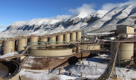
| Qualified Persons: | Gonzalo Mercado, P.Geo. Karla Michelle Calderon Guevara, CPG Andrew Pocock, P.Eng. Michael Jarred Deal, RM SME María Elena Vázquez Jaimes, P.Geo. |
|
| Report Prepared For: | First Majestic Silver Corp. | |
| Effective Date:
Report Date: |
August 31, 2025
September 24, 2025 |
|
| La Encantada Silver Mine Coahuila, Mexico NI 43-101 Technical Report on Mineral Resource and Mineral Reserve Estimates |
|
Table of Contents
| 1. SUMMARY |
1 | |||
| 1.1. Introduction |
1 | |||
| 1.2. Project Location, Description, and Access |
1 | |||
| 1.3. History |
3 | |||
| 1.4. Geological Setting, Mineralization and Deposit Types |
3 | |||
| 1.5. Exploration |
4 | |||
| 1.6. Drilling |
4 | |||
| 1.7. Sampling, Analysis and Data Verification |
4 | |||
| 1.8. Mineral Processing and Metallurgical Testing |
5 | |||
| 1.9. Mineral Resource and Mineral Reserve Estimates |
6 | |||
| 1.9.1. Mineral Resource Estimates |
6 | |||
| 1.9.2. Mineral Reserve Estimates |
9 | |||
| 1.10. Mining Operations |
11 | |||
| 1.11. Recovery Methods |
12 | |||
| 1.12. Infrastructure, Permitting and Compliance Activities |
13 | |||
| 1.13. Capital and Operating Costs |
15 | |||
| 1.14. Conclusions |
16 | |||
| 1.15. Recommendations |
16 | |||
| 2. INTRODUCTION |
17 | |||
| 2.1. Technical Report Issuer |
17 | |||
| 2.2. Terms of Reference |
17 | |||
| 2.3. Cut-off and Effective Date |
17 | |||
| 2.4. Qualified Persons |
17 | |||
| 2.5. Site Visits |
18 | |||
| 2.6. Sources of Information |
18 | |||
| 2.7. Previously Filed Technical Reports |
19 | |||
| 2.8. Units and Currency and Abbreviations |
19 | |||
| 3. RELIANCE ON OTHER EXPERTS |
21 | |||
| 4. PROPERTY DESCRIPTION AND LOCATION |
22 | |||
| 4.1. Location |
22 | |||
| 4.2. Ownership |
22 | |||
| 4.3. Mining Tenure |
23 | |||
| 4.4. Royalties |
24 | |||
| 4.5. Surface Rights |
25 | |||
| 4.6. Permits |
26 | |||
| 4.7. Environmental Considerations |
26 | |||
| 4.8. Existing Environmental Liabilities |
26 |
| i | September 2025 |
| La Encantada Silver Mine Coahuila, Mexico NI 43-101 Technical Report on Mineral Resource and Mineral Reserve Estimates |
|
| 4.9. Factors and Risks |
27 | |||
| 5. ACCESSIBILITY, CLIMATE, LOCAL RESOURCES, INFRASTRUCTURE AND PHYSIOGRAPHY |
28 | |||
| 5.1. Accessibility |
28 | |||
| 5.2. Physiography |
29 | |||
| 5.3. Climate |
29 | |||
| 5.4. Local Resources and Infrastructure |
29 | |||
| 6. HISTORY |
30 | |||
| 6.1. Production History |
31 | |||
| 7. GEOLOGICAL SETTING AND MINERALIZATION |
32 | |||
| 7.1. Regional Geology and Stratigraphy |
32 | |||
| 7.2. Regional Structure |
33 | |||
| 7.3. Local Geology and Stratigraphy |
35 | |||
| 7.4. Structural Geology |
38 | |||
| 7.5. Mineralization |
38 | |||
| 7.5.1. Overview |
38 | |||
| 7.5.2. Prieta Complex |
41 | |||
| 7.5.3. San Javier–Milagros Complex |
42 | |||
| 7.5.4. Vein Systems |
43 | |||
| 8. DEPOSIT TYPES |
45 | |||
| 9. EXPLORATION |
47 | |||
| 9.1. Geophysical Surveys |
48 | |||
| 9.1.1. Magnetic Surveys |
48 | |||
| 9.1.2. Natural Source Audio Magneto Telluric Survey |
49 | |||
| 9.2. Stable Isotope Analysis |
53 | |||
| 10. DRILLING |
55 | |||
| 10.1. Exploration and Infill Drilling |
55 | |||
| 10.2. Core Handling and Storage |
57 | |||
| 10.2.1. Data Collection |
57 | |||
| 10.2.2. Collar Survey |
57 | |||
| 10.2.3. Down-hole Survey |
58 | |||
| 10.2.4. Logging and Sampling |
58 | |||
| 10.2.5. Specific Gravity and Bulk Density |
59 | |||
| 10.2.6. Core Recovery and Geotechnical Logging |
60 | |||
| 11. SAMPLE PREPARATION, ANALYSES AND SECURITY |
61 | |||
| 11.1. Core Sampling |
61 | |||
| 11.2. Underground Production Channel Sampling |
61 | |||
| 11.3. Analytical Laboratories |
62 | |||
| 11.4. Sample Preparation and Analysis |
62 | |||
| 11.4.1. SGS Durango |
62 |
| ii | September 2025 |
| La Encantada Silver Mine Coahuila, Mexico NI 43-101 Technical Report on Mineral Resource and Mineral Reserve Estimates |
|
| 11.4.2. Central Laboratory |
63 | |||
| 11.4.3. Bureau Veritas |
63 | |||
| 11.4.4. La Encantada Laboratory |
63 | |||
| 11.5. Quality Control and Quality Assurance |
65 | |||
| 11.5.1. Materials and Insertion Rates |
65 | |||
| 11.5.2. Transcription and Sample Handling Errors |
65 | |||
| 11.5.3. Accuracy Assessment |
65 | |||
| 11.5.4. Contamination Assessment |
67 | |||
| 11.5.5. Precision Assessment |
68 | |||
| 11.5.6. Between-Laboratory Bias Assessment |
69 | |||
| 11.6. Databases |
70 | |||
| 11.7. Sample Security |
70 | |||
| 11.7.1. Production Channel Samples |
70 | |||
| 11.7.2. Core Samples |
71 | |||
| 11.8. Author’s Opinion |
71 | |||
| 12. DATA VERIFICATION |
72 | |||
| 12.1. Data Entry Error Checks |
72 | |||
| 12.2. Visual Data Inspection |
72 | |||
| 12.3. Review QA/QC Assay Results |
73 | |||
| 12.4. Author’s Opinion |
73 | |||
| 13. MINERAL PROCESSING AND METALLURGICAL TESTING |
74 | |||
| 13.1. Overview |
74 | |||
| 13.2. Metallurgical Testing |
74 | |||
| 13.2.1. Mineralogy |
74 | |||
| 13.2.2. Monthly Composite Samples |
75 | |||
| 13.2.3. Sample Preparation |
75 | |||
| 13.3. Comminution Evaluations |
75 | |||
| 13.4. Cyanidation, Reagent and Grind Size Evaluations |
76 | |||
| 13.5. Cyanidation with Lead Nitrate |
77 | |||
| 13.6. Cyanidation Higher pH Range |
78 | |||
| 13.7. Roasting and Cyanidation |
79 | |||
| 13.8. Ojuelas Geometallurgical Testing |
80 | |||
| 13.9. Geometallurgical Investigations |
81 | |||
| 13.10. Recovery Estimates |
83 | |||
| 13.11. Deleterious Elements |
83 | |||
| 14. MINERAL RESOURCE ESTIMATES |
85 | |||
| 14.1. Introduction |
85 | |||
| 14.2. Mineral Resource Estimation Process |
85 | |||
| 14.2.1. Sample Database |
86 |
| iii | September 2025 |
| La Encantada Silver Mine Coahuila, Mexico NI 43-101 Technical Report on Mineral Resource and Mineral Reserve Estimates |
|
| 14.2.2. Geological Interpretation and Modeling |
92 | |||
| 14.2.3. Exploratory Sample Data Analysis |
95 | |||
| 14.2.4. Boundary Analysis |
95 | |||
| 14.2.5. Compositing |
97 | |||
| 14.2.6. Evaluation of Composite Sample Outlier Values |
98 | |||
| 14.2.7. Composite Sample Statistics |
100 | |||
| 14.2.8. Metal Trend and Spatial Analysis: Variography |
103 | |||
| 14.2.9. Bulk Density |
104 | |||
| 14.2.10. Block Model Setup |
105 | |||
| 14.2.11. Block Model Estimation |
106 | |||
| 14.2.12. Block Model Validation |
113 | |||
| 14.2.13. Mineral Resource Classification |
117 | |||
| 14.2.14. Reasonable Prospects for Eventual Economic Extraction |
118 | |||
| 14.2.15. Mining Depletion |
120 | |||
| 14.3. Statement of Mineral Resource Estimates |
121 | |||
| 14.4. Factors that May Affect the Mineral Resource Estimates |
124 | |||
| 14.5. Comments on Section 14 |
125 | |||
| 15. MINERAL RESERVES ESTIMATES |
126 | |||
| 15.1. Mineral Reserves Estimation Methodology |
126 | |||
| 15.2. NSR and Cut-off Grade Estimation |
127 | |||
| 15.3. Block Model Preparation |
130 | |||
| 15.4. Mining Modifying Factors – Dilution and Mining Loss |
130 | |||
| 15.5. Potentially Mineable Shapes and Mine Design |
134 | |||
| 15.6. Mineral Reserves Estimate |
135 | |||
| 15.7. Factors that May Affect the Mineral Reserve Estimates |
135 | |||
| 16. MINING METHODS |
136 | |||
| 16.1. Overview |
136 | |||
| 16.2. Mining Environment |
136 | |||
| 16.2.1. Hydrogeological Considerations |
136 | |||
| 16.2.2. Geotechnical Considerations |
137 | |||
| 16.3. Mining Methods |
140 | |||
| 16.3.1. Design Parameters |
140 | |||
| 16.3.2. Sublevel Caving |
142 | |||
| 16.3.3. Longhole Stoping |
143 | |||
|
16.3.4. Cut-and-Fill |
145 | |||
| 16.4. Mine Layout-Ojuelas |
146 | |||
| 16.5. Mine Layout Vein-type Deposits |
150 | |||
| 16.6. Dilution and Mining Loss |
152 | |||
| 16.7. Development and Production Schedule |
153 |
| iv | September 2025 |
| La Encantada Silver Mine Coahuila, Mexico NI 43-101 Technical Report on Mineral Resource and Mineral Reserve Estimates |
|
| 16.7.1. Vertical Development |
153 | |||
| 16.7.2. Longhole Drilling |
153 | |||
| 16.7.3. Life of Mine Production Schedule |
154 | |||
| 16.8. Mine Services |
156 | |||
| 16.8.1. Ore and Waste Handling |
156 | |||
| 16.8.2. Ventilation |
156 | |||
| 16.8.3. Mine Dewatering |
158 | |||
| 16.8.4. Compressed Air and Services Water |
158 | |||
| 16.9. Equipment and Manpower Requirements |
158 | |||
| 16.9.1. Manpower |
158 | |||
| 16.9.2. Equipment |
158 | |||
| 16.9.3. Mine Contractors |
159 | |||
| 17. RECOVERY METHODS | 160 | |||
| 17.1. Introduction |
160 | |||
| 17.2. Process Flowsheet |
160 | |||
| 17.3. Process Plant Configuration |
162 | |||
| 17.3.1. Plant Feed |
162 | |||
| 17.3.2. Crushing |
162 | |||
| 17.3.3. Grinding |
163 | |||
| 17.3.4. Sampling |
163 | |||
| 17.3.5. Cyanide Leaching Circuit |
164 | |||
| 17.3.6. Counter Current Decantation System |
164 | |||
| 17.3.7. Merrill Crowe and Precipitate Handling |
164 | |||
| 17.3.8. Roasting Circuit |
165 | |||
| 17.4. Processing Plant Requirements |
167 | |||
| 18. INFRASTRUCTURE | 170 | |||
| 18.1. Local Infrastructure |
170 | |||
| 18.2. Transportation and Logistics |
171 | |||
| 18.3. Waste Rock Storage Facilities |
171 | |||
| 18.4. Filtered Tailings Storage Facilities |
172 | |||
| 18.5. Camps and Accommodation |
173 | |||
| 18.6. Electrical Power |
174 | |||
| 18.7. Communications |
174 | |||
| 18.8. Water Supply |
174 | |||
| 19. MARKET CONSIDERATION AND CONTRACTS | 175 | |||
| 19.1. Market Considerations |
175 | |||
| 19.2. Commodity Price Guidance |
175 | |||
| 19.3. Product and Sales Contracts |
175 | |||
| 19.4. Royalty Agreement |
176 |
| v | September 2025 |
| La Encantada Silver Mine Coahuila, Mexico NI 43-101 Technical Report on Mineral Resource and Mineral Reserve Estimates |
|
| 19.5. Deleterious Elements |
176 | |||
| 19.6. Supply and Services Contracts |
176 | |||
| 19.7. Comments on Section 19 |
176 | |||
| 20. ENVIRONMENTAL STUDIES, PERMITTING, AND SOCIAL OR COMMUNITY IMPACT |
178 | |||
| 20.1. Environmental Aspects, Studies and Permits |
178 | |||
| 20.1.1. General |
178 | |||
| 20.1.2. Environmental Compliance in Mexico |
178 | |||
| 20.1.3. Existing Environmental Conditions |
179 | |||
| 20.1.4. Relevant Environmental Impact Aspects |
179 | |||
| 20.2. Summary of Relevant Environmental Obligations |
180 | |||
| 20.3. Permitting |
181 | |||
| 20.3.1. Current Permits |
182 | |||
| 20.3.2. Permits in Process |
182 | |||
| 20.4. Mine Closure Aspects |
183 | |||
| 20.5. Social and Community Aspects |
183 | |||
| 21. CAPITAL AND OPERATING COST |
184 | |||
| 21.1. Sustaining Capital Costs |
184 | |||
| 21.2. Operating Costs |
185 | |||
| 22. ECONOMIC ANALYSIS |
186 | |||
| 23. ADJACENT PROPERTIES |
187 | |||
| 24. OTHER RELEVANT DATA AND INFORMATION |
188 | |||
| 25. INTERPRETATION AND CONCLUSIONS |
189 | |||
| 25.1. Mineral Tenure, Surface Rights and Agreements |
189 | |||
| 25.2. Geology and Mineralization |
189 | |||
| 25.3. Exploration and Drilling |
189 | |||
| 25.4. Data Analysis |
190 | |||
| 25.5. Metallurgical Testwork |
190 | |||
| 25.6. Mineral Resource Estimates |
191 | |||
| 25.7. Mineral Reserve Estimates |
191 | |||
| 25.8. Mine Plan |
192 | |||
| 25.9. Processing |
192 | |||
| 25.10. Infrastructure |
192 | |||
| 25.11. Markets and Contracts |
193 | |||
| 25.12. Permitting, Environmental and Social Considerations |
193 | |||
| 25.13. Capital and Operating Cost Estimates |
193 | |||
| 25.14. Economic Analysis Supporting Mineral Reserve Declaration |
193 | |||
| 25.15. Conclusions |
194 | |||
| 26. RECOMMENDATIONS |
195 | |||
| 26.1.1. Exploration |
195 |
| vi | September 2025 |
| La Encantada Silver Mine Coahuila, Mexico NI 43-101 Technical Report on Mineral Resource and Mineral Reserve Estimates |
|
| 26.1.2. Roasting |
195 | |||
| 27. REFERENCES |
196 | |||
| 28. CERTIFICATES OF QUALIFIED PERSON |
199 |
| vii | September 2025 |
| La Encantada Silver Mine Coahuila, Mexico NI 43-101 Technical Report on Mineral Resource and Mineral Reserve Estimates |
|
Index of Tables
| Table 1-1: La Encantada Mineral Resource Estimate Statement, Indicated Category (effective date December 31, 2024) |
8 | |||
| Table 1-2: La Encantada Mineral Resource Estimate Statement, Inferred Category (effective date December 31, 2024) |
8 | |||
| Table 1-3: La Encantada Mineral Reserves Statement (Effective Date December 31, 2024) |
10 | |||
| Table 1-4: Development Schedule for La Encantada |
11 | |||
| Table 1-5: La Encantada Mining Capital Costs Summary (Sustaining Capital) |
15 | |||
| Table 1-6: La Encantada Operating Costs |
15 | |||
| Table 1-7: La Encantada Annual Operating Costs |
15 | |||
| Table 2-1: List of Abbreviations and Units |
20 | |||
| Table 4-1: List of Minera La Encantada Mining Concessions |
23 | |||
| Table 10-1: Drill Holes Completed by First Majestic, La Encantada |
55 | |||
| Table 10-2: Summary of SG Results |
59 | |||
| Table 11-1: Analytical Laboratories |
62 | |||
| Table 11-2: Laboratory Analytical Methods |
64 | |||
| Table 11-3: Summary Between Laboratory Bias. Silver Results |
69 | |||
| Table 13-1: Grindability Test Results for Different Composite Samples of La Encantada Mine |
76 | |||
| Table 13-2: Metallurgical Recoveries by Year |
83 | |||
| Table 13-3: Metallurgical Recoveries by Domain |
83 | |||
| Table 14-1: Drill Hole Sample Data by Domain, La Encantada |
89 | |||
| Table 14-2: Production Channel Sample Data by Domain, La Encantada |
90 | |||
| Table 14-3: Mine Area, Ore Nature, Host-Rock, Resource Domains and Codes, La Encantada |
92 | |||
| Table 14-4: Composite Sample Preparation, La Encantada |
97 | |||
| Table 14-5: Declustered Composite Sample Capping Statistics by Domain, Prieta Complex |
99 | |||
| Table 14-6: Declustered Composite Sample Capping Statistics by Domain, San Javier Milagros Complex |
100 | |||
| Table 14-7: Declustered Composite Sample Capping Statistics by Domain, Vein Systems and Tailings |
100 | |||
| Table 14-8: Ag Declustered Composite Sample Statistics by Domain, Prieta Complex |
101 | |||
| Table 14-9: Ag Declustered Composite Sample Statistics by Domain, San Javier Milagros Complex |
102 | |||
| Table 14-10: Ag Declustered Composite Sample Statistics by Domain, Vein Systems and Tailings |
103 | |||
| Table 14-11: SG Statistics by Resource Domain |
105 | |||
| Table 14-12: Block Model Parameters |
106 | |||
| Table 14-13: Summary of Ag Estimation Parameters for the Prieta Complex Block Models |
109 | |||
| Table 14-14: Summary of Ag Estimation Parameters for the San Javier Milagros Complex Block Models |
110 | |||
| Table 14-15: Summary of Ag Estimation Parameters for Vein Systems Block Models |
110 | |||
| Table 14-16: Summary of Ag Estimation Parameters for the Tailings Block Model |
112 | |||
| Table 14-17: Mineral Resource Estimate Statement Reporting Groups for La Encantada with Associated Mining Method |
123 |
| viii | September 2025 |
| La Encantada Silver Mine Coahuila, Mexico NI 43-101 Technical Report on Mineral Resource and Mineral Reserve Estimates |
|
| Table 14-18: La Encantada Mineral Resource Estimate Statement, Indicated Category (effective date December 31, 2024) |
124 | |||
| Table 14-19: La Encantada Mineral Resource Estimate Statement, Inferred Category (effective date December 31, 2024) |
124 | |||
| Table 15-1: Assumptions for NSR Calculation |
128 | |||
| Table 15-2: Assumptions for COG Calculation |
129 | |||
| Table 15-3: Silver Recoveries by Domain for COG Calculation |
129 | |||
| Table 15-4: Run of Mine COGs by Domain and Mining Method |
130 | |||
| Table 15-5: Example Calculation of Planned and Unplanned Dilution for Vein Systems |
134 | |||
| Table 15-6: Parameters for Creation of Potentially Minable Stope Shapes |
134 | |||
| Table 15-7: La Encantada Mineral Reserves Statement (Effective Date December 31, 2024) |
135 | |||
| Table 16-1 Rock Characteristics by Zone |
137 | |||
| Table 16-2: Development Types and Support Standards for La Encantada |
142 | |||
| Table 16-3: Development Schedule for La Encantada |
153 | |||
| Table 16-4: Equipment Types |
154 | |||
| Table 16-5: Production Schedule |
156 | |||
| Table 16-6: Required Equipment for the LOM plan |
159 | |||
| Table 17-1: Processing Plant Requirements for the LOM Plan |
169 | |||
| Table 20-1: Major Permits granted to La Encantada |
182 | |||
| Table 21-1: La Encantada Mining Capital Costs Summary (Sustaining Capital) |
185 | |||
| Table 21-2: La Encantada Operating Costs |
185 | |||
| Table 21-3: La Encantada Annual Operating Costs |
185 |
| ix | September 2025 |
| La Encantada Silver Mine Coahuila, Mexico NI 43-101 Technical Report on Mineral Resource and Mineral Reserve Estimates |
|
Index of Figures
| Figure 1-1: LOM Production Schedule |
12 | |||
| Figure 4-1: Location Map of La Encantada Silver Mine |
22 | |||
| Figure 4-2: Minera La Encantada Mining Concessions |
24 | |||
| Figure 4-3: Map of Minera La Encantada Surface Rights |
26 | |||
| Figure 5-1: Access to La Encantada |
28 | |||
| Figure 6-1: Mine and Silver Production since 2014 |
31 | |||
| Figure 7-1: Map of Mexico Showing the SMO Physiography and location of La Encantada Silver Mine |
32 | |||
| Figure 7-2: Map of Northern Coahuila Showing the Sabinas Basin and the Regional La Babia and San Marcos Faults |
34 | |||
| Figure 7-3: Panoramic View of La Encantada Range Front Exposing the Aurora Formation |
35 | |||
| Figure 7-4: Geological Map of La Encantada Property |
36 | |||
| Figure 7-5: Stratigraphic Column for La Encantada |
37 | |||
| Figure 7-6: Mineral Deposits at La Encantada. Plan View. |
40 | |||
| Figure 7-7: Plan View and Vertical Section of the Prieta Complex. |
41 | |||
| Figure 7-8: Vertical Section and Plan View of the San Javier Milagros Complex |
43 | |||
| Figure 7-9: The Milagros Breccia Visible at the 1660 UG Level |
43 | |||
| Figure 7-10: Plan View and Vertical Section of the Vein Systems. |
44 | |||
| Figure 8-1: Schematic of Carbonate Replacement Deposit Model |
46 | |||
| Figure 9-1: Location Map of Exploration Areas Showing Surface Rock Chip sample results |
47 | |||
| Figure 9-2: RTP Map Showing Magnetic Highs in Exploration Areas of Interest |
49 | |||
| Figure 9-3: Map Showing the Location of the NSAMT Survey Lines |
50 | |||
| Figure 9-4: NSAMT Section Across Anomaly A |
51 | |||
| Figure 9-5: NSAMT Section Across Anomaly B |
52 | |||
| Figure 9-6: Location Map of Isotope Sampling and Results of ä18O for the northwest line |
54 | |||
| Figure 10-1: Drill Hole Location Map, La Encantada |
56 | |||
| Figure 11-1: Central Laboratory High Grade CRM Standard Control Chart |
66 | |||
| Figure 11-2: Time Sequence Pulp Blank Performance Chart, La Encantada Laboratory Silver Results 2019-2024 |
68 | |||
| Figure 11-3: RMA Plot Ranges Above 100 ppm Ag. La Encantada Laboratory 2019–2024 Check Results . |
70 | |||
| Figure 13-1: Typical Distribution of Minerals, La Encantada |
75 | |||
| Figure 13-2: Comparison of Ag Extraction Between Mill and Laboratory Performances |
77 | |||
| Figure 13-3: Lead Nitrate Test Results |
78 | |||
| Figure 13-4: La Encantada Silver Recovery for Higher pH Range |
79 | |||
| Figure 13-5: La Encantada Box Plot of Silver Recovery for Higher pH Range |
79 | |||
| Figure 13-6: Tailings “High Manganese” Test Results |
80 | |||
| Figure 13-7: Flowsheet Sequence – Ojuelas Metallurgical Testing Investigation |
81 | |||
| Figure 13-8: Silver Extraction from Ojuelas Mine |
81 | |||
| Figure 13-9: La Encantada Box Plot of Silver Head Grades 2024 |
82 | |||
| Figure 13-10: La Encantada Box Plot of Silver Recoveries Grades 2024 |
82 | |||
| Figure 13-11: Monthly Dore Purity 2021 -2024 |
84 | |||
| Figure 13-12: La Encantada Box Plot of Lead Dore Concentration 2021- 2024 |
84 | |||
| Figure 14-1: Drill Hole and Channel Locations, Resource Domains, and Mine Areas: Plan View |
91 |
| x | September 2025 |
| La Encantada Silver Mine Coahuila, Mexico NI 43-101 Technical Report on Mineral Resource and Mineral Reserve Estimates |
|
| Figure 14-2: Vertical Section and Plan View Location of the San Javier–Milagros Complex Domains |
93 | |||
| Figure 14-3: Plan View Location and Vertical Section of the Vein Systems Domains |
94 | |||
| Figure 14-4: Plan View Location and Vertical Section of the Prieta Complex Domains |
94 | |||
| Figure 14-5: Vertical Section and Plan View Location of the Tailings Deposit No. 4 Domain |
95 | |||
| Figure 14-6: Example of Hard Boundary Silver Conditions for the Veta Conejo |
96 | |||
| Figure 14-7: Example of Soft Boundary Silver Conditions Between Cuerpo Ojuelas Sub-Domains: Carbonate Replacement against Skarn Alteration |
96 | |||
| Figure 14-8: Sample Interval Lengths, Composited vs. Uncomposited – Cuerpo Ojuelas Domain |
98 | |||
| Figure 14-9: Example of Global Analysis of Outlier Values, Cuerpo Ojuelas |
99 | |||
| Figure 14-10: Ag Box Plots of Declustered Composite Sample Statistics by Domain, Prieta Complex |
101 | |||
| Figure 14-11: Ag Box Plot of Declustered Composite Sample Statistics by Domain, San Javier-Milagros Complex |
102 | |||
| Figure 14-12: Ag Box Plot of Declustered Composite Sample Statistics by Domain, Vein Systems and Tailings |
102 | |||
| Figure 14-13: Ag Variogram Models for Cuerpo Ojuelas |
104 | |||
| Figure 14-14: An Example of 2-Pass Estimation Strategy used for the VCNJ Domain, Vertical Section with Plan View Reference to the Right |
113 | |||
| Figure 14-15: Visual Inspection of Cuerpo Ojuelas Ag Block Model Estimates and Composite Sample Values, Vertical Section and Plan View |
114 | |||
| Figure 14-16: Visual Inspection of Tailings Deposit No. 4 Ag Block Model Estimate and Composite Sample Values, Vertical Section and Plan View |
114 | |||
| Figure 14-17: Conditional Bias Scatterplot of Ag Composite and Estimated Ag Block Values, Cuerpo Milagros Breccia |
115 | |||
| Figure 14-18: Global Mean Ag Grade Bias Check for Resource Domains of the Prieta Complex Comparing Raw Assay to Declustered Composite Mean Grades and Mean Block Grades |
116 | |||
| Figure 14-19: Ag Mean Value Swath Plot Across Cuerpo Ojuelas in Y and Z |
117 | |||
| Figure 14-20: Indicated and Inferred Mineral Resource Categories, Veta Dique San Francisco Domain |
118 | |||
| Figure 14-21: Block Model Example of Underground Mining Excavations at the Prieta Complex, C660 Area |
120 | |||
| Figure 15-1: Schematic of Planned and Unplanned Dilution |
131 | |||
| Figure 15-2: Schematic Example of Dilution and Mining Loss in Longhole Mining |
132 | |||
| Figure 15-3: Schematic Example of Dilution and Mining Loss in Cut & Fill Mining |
133 | |||
| Figure 16-1: La Encantada 10 Year Water Supply History |
136 | |||
| Figure 16-2: Typical Ground Support Standard |
139 | |||
| Figure 16-3: Example Geotechnical Domains for La Encantada |
141 | |||
| Figure 16-4: Sublevel Caving Schematic Model |
143 | |||
| Figure 16-5: Longhole Open Stoping Schematic Model |
144 | |||
| Figure 16-6: Cut-and-fill Mining Method Schematic Model |
146 | |||
| Figure 16-7: Plan View of Ojuelas 1480 Level Layout |
147 | |||
| Figure 16-8: Plan View of Ojuelas 1465 Level Layout |
148 | |||
| Figure 16-9: Cross Section of the Ojuelas Sublevel Cave Design |
149 | |||
| Figure 16-10: Long Section of the Ojuelas Sublevel Cave Design looking North |
149 | |||
| Figure 16-11: Section View of the simulated stresses for the Veta Dique San Francisco Stope, Looking North |
151 | |||
| Figure 16-12: Cross Section View of Mine Plan for the Veta Dique San Francisco Deposit |
152 |
| xi | September 2025 |
| La Encantada Silver Mine Coahuila, Mexico NI 43-101 Technical Report on Mineral Resource and Mineral Reserve Estimates |
|
| Figure 16-13: Mine Production Material Movement |
154 | |||
| Figure 16-14: Ventilation Circuit for Prieta Complex Mine Area |
157 | |||
| Figure 16-15: Ventilation Circuit for La Encantada Mine Area |
157 | |||
| Figure 17-1: La Encantada Schematic Comminution Plant Flowsheet, Plant No. 1 |
161 | |||
| Figure 17-2: La Encantada Processing Plant Flowsheet |
162 | |||
| Figure 17-3: Aerial View of the Roaster Circuit |
166 | |||
| Figure 17-4: 3D-Model of Proposed Improvements for the Roaster Circuit |
167 | |||
| Figure 18-1: Aerial Photo Showing Local Infrastructure at La Encantada |
171 | |||
| Figure 18-2: Waste Rock Storage Facilities |
172 | |||
| Figure 18-3: Tailings Storage Facilities |
173 | |||
| Figure 18-4: LNG Power Generation Plant |
174 |
| xii | September 2025 |
| La Encantada Silver Mine Coahuila, Mexico NI 43-101 Technical Report on Mineral Resource and Mineral Reserve Estimates |
|
| 1. | SUMMARY |
| 1.1. | Introduction |
La Encantada Silver Mine (“La Encantada”, “the La Encantada mine”) is owned and operated by Minera La Encantada S.A de C.V. (“MLE”) which is an indirectly wholly owned subsidiary of First Majestic Silver Corp. (“First Majestic”). First Majestic acquired the La Encantada mine from Desmin S.A. de C.V. (“Desmin”) on November 1, 2006.
La Encantada operations consist of an operating underground mine, two processing plants and two Filtered Tailings Storage Facilities (“FTSF”), one active, one inactive.
This Technical Report provides information on Mineral Resource and Mineral Reserve estimates, and mine and process operations and planning for the La Encantada mine. The Mineral Resource and Mineral Reserve estimates are reported in accordance with the Canadian Institute of Mining, Metallurgy and Petroleum (“CIM”) Definition Standards for Mineral Resources and Mineral Reserves (May 2014; the 2014 CIM Definition Standards).
The effective date of the Mineral Resource and Mineral Reserve estimates presented in this Technical Report is December 31, 2024, which represents the cut-off date for the most relevant scientific and technical information used in the Report. The effective date for this Technical Report is August 31, 2025.
In the opinion of the undersigned Qualified Person(s), the scientific and technical information contained in this Technical Report is current as of the Technical Report’s effective date. The Mineral Resource and Mineral Reserve estimates are supported by data and interpretations valid as of December 31, 2024, and no material changes have occurred between that date and the Technical Report’s effective date that would impact the conclusions herein.
Mr. Gonzalo Mercado, Ms. Karla Michelle Calderon Guevara, Mr. Andrew Pocock, Ms. María Elena Vázquez Jaimes, and Mr. Michael Jarred Deal are the Qualified Persons (“QP”) that prepared this technical report (the Technical Report) on the La Encantada Silver Mine. The QPs visited the mine on numerous occasions.
Units of measure are metric unless otherwise noted. All costs and metal prices are expressed in United States dollars unless otherwise noted.
| 1.2. | Project Location, Description, and Access |
La Encantada is an actively producing silver mining complex located in the municipality of Ocampo, State of Coahuila, Mexico, approximately 120 km northwest of the city of Melchor Múzquiz, Coahuila and approximately 120 km north of the town of Ocampo, Coahuila. The property is located in the La Encantada mountain range which runs for about 45 km in the northwest–southeast direction and has elevations that vary from about 1,500 m to over 2,400 m.
| 1 | September 2025 |
| La Encantada Silver Mine Coahuila, Mexico NI 43-101 Technical Report on Mineral Resource and Mineral Reserve Estimates |
|
Mining operations can be conducted year-round in the La Encantada mine.
La Encantada consists of 22 exploitation concessions covering 4,076 ha, which are operated and owned by MLE. All 22 concessions are currently in good standing. The oldest of the concessions was granted in 1965 and the most recent in 2008.
In 2013, the Mexican Federal government introduced a mining royalty, effective January 1, 2014, based on 7.5% of taxable earnings before interest and depreciation. In addition, precious metal mining companies must pay a 0.5% royalty on revenues from gold, silver, and platinum. In 2025, the Mexican Federal Government amended the law and increased the rights from 7.5% to 8.5% of the taxable earnings before interest and depreciation and from 0.5% to 1% royalty on revenues from gold, silver, and platinum.
Surface rights in the area of the mining concessions are held both privately and through group ownership either as communal lands or Ejido lands. MLE owns surface rights covering 2,237 ha on the “Canon del Regalado” properties. This surface covers the following features: access to the mining complex, mine portals, grinding mill and flotation plant (Plant No. 1), cyanidation plant (Plant No. 2), tailings management facilities, the mine camp, offices, and an airstrip.
In 2011 the Tenochtitlán Ejido filed a lawsuit against MLE in agrarian court claiming title to 1,097 ha of the land owned by MLE. The initial lawsuit was decided in favour of MLE and was followed by a series of motions and appeals regarding judicial reviews of the subsequent rulings. Resumption of the initial lawsuit regarding the land title is currently pending a judicial review ruling. MLE has strengthened its relationship with the Tenochtitlán Ejido through ongoing dialogue and is working toward reaching an amicable settlement outside of court. Should Tenochtitlan Ejido obtain a resolution in their favour, negotiations will be needed for compensation of the 1,097 ha.
Access to La Encantada is primarily by charter airplane from Durango city (about two hours flying time), or from the city of Torreón, Coahuila (about 1:15 hours flying time). MLE operates its own private airstrip at the La Encantada mine. Driving time from the city of Melchor Múzquiz is approximately 2.5 hours by asphalt road, about five hours from the town of Ocampo and about eight hours from the international airport in Torreón city.
The remote location required the construction of substantial infrastructure, which was developed during an extended period of active operation by First Majestic and the mine’s previous owners. La Encantada camp consists of 160 houses for accommodation of employees, offices, warehouses, a union hall, a church, a hospital, water purification plant, water treatment plant, water wells and an airstrip.
Power supply to the mine, processing facilities and camp site is from diesel and natural gas generators provided by First Majestic. First Majestic also provides potable water. Most of the supplies and labour required for the operation are sourced from the city of Múzquiz, Coahuila, or directly from suppliers.
| 2 | September 2025 |
| La Encantada Silver Mine Coahuila, Mexico NI 43-101 Technical Report on Mineral Resource and Mineral Reserve Estimates |
|
| 1.3. | History |
In 1967, Industrias Peñoles, S.A.B. de C.V. (Peñoles) and Tormex established a joint venture partnership (Minera La Encantada) to acquire and develop La Encantada. In July 2004, Peñoles awarded a contract to operate the Encantada mine, including the processing plant and all mine infrastructure facilities, to the private Mexican company Desmin. Desmin operated the mine and processing plant until November 1, 2006, when First Majestic purchased all the outstanding shares of Desmin. Subsequently, First Majestic reached an agreement to acquire all the outstanding shares of MLE from Peñoles.
First Majestic is now the sole owner of La Encantada and all its assets, including mineral rights, surface rights position, water rights, processing plants and ancillary facilities.
| 1.4. | Geological Setting, Mineralization and Deposit Types |
La Encantada consists of polymetallic (silver, iron, lead, and zinc) oxide carbonate replacement and tabular vein deposits hosted by Cretaceous carbonate sedimentary formations. At deeper structural levels, silver–gold–lead–zinc and sulphide mineralization are hosted in skarn alteration associated with a granodiorite intrusion.
A granodiorite stock, and rhyolite to basalt dikes of Eocene–Oligocene age intrudes the Cretaceous carbonate rocks. Intrusion-related alteration of the wall rocks produced irregular skarn, hornfels and marble aureoles. Due to its spatial relationship to the skarn alteration and mineralization, it is believed that the intrusion is genetically linked to the polymetallic mineralization.
La Encantada lies on the southwestern flank of the northwest-trending Sierra de La Encantada anticlinorium and the deposits occur along a series of northeast-trending faults and fractures that cut obliquely across the regional north–northwest-trending anticlinorium. The northeast-trending normal faults and fractures control the formation of breccia pipes and vein shoots at intersections with the northwest-trending cross structures.
Mineralization consists of polymetallic, high-temperature, intrusion-related carbonate-replacement and minor skarn-hosted deposits. Mineralization occurs as tabular veins, mantos, massive lenses, breccia pipes, and irregular replacement zones. The deposits were grouped into four geological zones: the Prieta complex, the San Javier–Milagros complex, the Vein systems, and Filtered Tailings Storage Facility No. 4.
Mineralization consists of secondary oxide minerals including silver, iron, zinc, lead, copper oxides and native silver. Native silver and oxide minerals also occur with sulphides in skarn and carbonate replacement zones where sulphides are partially converted to oxide minerals. The sulphide minerals acanthite, pyrite, magnetite, marmatite (iron-rich sphalerite), galena, chalcopyrite, and covellite occur in the Prieta and the San Javier–Milagros complexes.
The silver mineral deposits at La Encantada are high-temperature polymetallic replacement deposits hosted in sedimentary carbonate rocks related to felsic intrusions and controlled by local and regional
| 3 | September 2025 |
| La Encantada Silver Mine Coahuila, Mexico NI 43-101 Technical Report on Mineral Resource and Mineral Reserve Estimates |
|
structures. Carbonate replacement deposits are characterized by irregular shaped pods, lenses, and tabular masses of oxides. Some replacement deposits are associated with skarn alteration and mineralization is also hosted by the sedimentary carbonate rocks.
The Filtered Tailings Storage Facility No. 4 consists of cyanidation circuit filtered tailings from previously processed ore that has been stacked on the surface close to cyanidation Plant No. 2.
| 1.5. | Exploration |
Surface exploration work completed by First Majestic includes geological mapping, geochemical sampling, a natural source audio-frequency magnetotellurics (“NSAMT”) geophysical survey, acquisition and processing of regional aeromagnetic data, an isotopic study, and core drilling. Surface geological mapping and sample geochemistry was completed in the El Camello, Anomaly B, La Escalera and El Plomo areas. Surface drilling was completed at Ojuelas in Prieta Complex, El Camello, El Plomo, Conejo Extension, Brecha Encanto, Veta Sucia, El Monje and other areas that had geologic, geochemical and or geophysical anomalies.
Underground exploration primarily consists of a combination of drilling and mine development along structures due to the complexity of the mineralized bodies.
| 1.6. | Drilling |
From 2011–2024, First Majestic conducted diamond core drilling programs for exploration purposes and to support geological interpretations, modelling, and Mineral Resource estimation. No reverse circulation (“RC”) drilling has been conducted by First Majestic. Channel sampling from underground mine developments was conducted to provide information for geological models, support mine production, and Mineral Resource estimation.
Between March 2011 and December 2024, several drilling campaigns were completed at La Encantada. Total drilling during this period amounts to more than 152,914 m in surface and underground diamond drillholes.
Data collected from drilling includes collar surveys, downhole surveys, logging (lithology, alteration, mineralization, structure, veins, sampling, etc.), specific gravity (“SG”), and geotechnical information.
| 1.7. | Sampling, Analysis and Data Verification |
Diamond drill core is delivered to the core logging facility where La Encantada geologists select and mark sample intervals according to lithological contacts, mineralization, alteration, and structural features. Sample intervals range from 0.25–1.20 m in length within mineralized structures to 0.5–1.20 m in length when sampling waste rock.
| 4 | September 2025 |
| La Encantada Silver Mine Coahuila, Mexico NI 43-101 Technical Report on Mineral Resource and Mineral Reserve Estimates |
|
All core intervals selected for sampling are cut in half using a diamond blade saw. One half of the core is retained in the core box and the other half is placed in sample bags for shipment to the laboratory. Sample tickets displaying the sample number are stapled into the core box beside the sampled interval, and a copy is placed in the sample bag. Sample bags are sealed to prevent contamination during handling and transportation.
Three-meter spaced production channel samples are used for geological models, grade control and to support Mineral Resource Estimation. Channel sample intervals range from 0.30–1.5 m and respect vein/wall contacts. From 2014 to 2015, 12 m spaced sawn channel samples were also collected to support Mineral Resource estimation.
Since 1995, four different laboratories have been used for sample preparation and analysis. These include the First Majestic Central Laboratory (“Central Laboratory”), the La Encantada Laboratory, SGS Durango, and Bureau Veritas Laboratories (“Bureau Veritas”).
Since 2013 quality assurance and quality control (“QA/QC”) samples submitted to the primary laboratories include standard reference materials (“SRMs”), certified reference materials (“CRMs”), coarse and pulp blanks, and field, coarse and pulp duplicates. Check samples sent to a secondary laboratory was introduced in 2014 and became a customary practice by 2018.
First Majestic assesses between-laboratory bias in terms of the slope of a reduced major axis (“RMA”) line. The RMA analysis of samples submitted to all secondary laboratories indicate no significant bias between the primary laboratory and the second laboratory.
The data verification included data entry error checks, visual inspections of data collected between 2013 and 2024, and a review of QA/QC assay results was completed. Several site visits were completed as part of the data verification process. No significant differences were observed.
| 1.8. | Mineral Processing and Metallurgical Testing |
La Encantada is an operating mine where the metallurgical test work data used to support the initial plant design has been consistently validated and reinforced by years of operational results, complemented by more recent metallurgical studies.
Metallurgical testing and mineralogical investigations are routinely conducted to support ongoing performance optimization. The plant continuously performs tests to improve silver recovery and reduce operating costs, even when current performance falls within expected parameters. This test work is conducted by the on-site Metallurgical Laboratory.
The presence of manganese in the mineralized material has been identified as a limiting factor for silver recovery. Several tests were performed on high-manganese material to assess the effectiveness of roasting as a pre-conditioning step prior to cyanide leaching. Some tests achieved silver recoveries between 57% and 73%, supporting the potential inclusion of a roasting circuit for processing material from Filtered Tailings Storage Facility No. 4.
| 5 | September 2025 |
| La Encantada Silver Mine Coahuila, Mexico NI 43-101 Technical Report on Mineral Resource and Mineral Reserve Estimates |
|
Additional roasting tests were conducted on run-of-mine (ROM), material with high manganese content, which is refractory in nature. Samples from the Buenos Aires deposit yielded silver recoveries of 68% to 71% after roasting followed by leaching. Although the roasting circuit is currently inactive, studies are ongoing to determine the required modifications to the cooling stage and material handling systems to enable its commissioning.
The metallurgical recovery projections in the life of mine plan (LOM) are supported by both the historical performance of the processing plant and results from recent testing. Recovery variability is addressed by assigning different recovery assumptions to specific geological domains. The average annual silver recovery projected in the LOM plan ranges from 60% to 68%.
The doré produced at La Encantada contains 60% to 85% silver, depending on the presence of base metals such as copper, lead, and zinc. The silver content affects the treatment charges, which are calculated based on the weight of the doré. These charges were incorporated into the cut-off grade calculations and the economic analysis supporting the LOM plan.
| 1.9. | Mineral Resource and Mineral Reserve Estimates |
| 1.9.1. | Mineral Resource Estimates |
The geological modelling, data analysis, and block model resource estimates for La Encantada were completed by Karla Michelle Calderon Guevara, CPG, a First Majestic employee.
The block model Mineral Resource estimates for La Encantada are based on the current database of exploration drill holes and production channel samples, the underground level geological mapping, the geological interpretation and model, the surface topography, and underground mining excavation wireframes. The combined drill hole and channel sample database for La Encantada was reviewed and verified by the resource geologists and supports that the QA/QC programs were reasonable.
The Mineral Resource estimates for the deposits at La Encantada are constrained by 3D geological interpretation and resource domain models constructed from drill hole core logs, drill hole and production channel sample assay intervals, and underground geological maps produced by the mine’s geology staff. Silver estimates are restricted to detailed wireframe domain models. Thirty-seven resource domains were constructed for the four mine areas.
Exploratory data analysis was completed for silver assay sample values to assess the statistical and spatial character of the sample data. Boundary analysis was completed to review the change in metal grade across the domain contacts.
To assess the statistical character of the composite samples within each of domains, data were declustered to account for over-sampling in certain regions. Composite lengths vary from 1-2 m by domain, with short residual composite samples left at the end of the vein intersection added to the previous interval.
| 6 | September 2025 |
| La Encantada Silver Mine Coahuila, Mexico NI 43-101 Technical Report on Mineral Resource and Mineral Reserve Estimates |
|
The drill hole and channel composite samples were evaluated for high-grade outliers. Capping of composite sample values was limited to a select few extreme values. Outlier restriction was also used to restrict the influence of high-grade samples.
Bulk density for the resource domains was either estimated into the block models from the SG core data or the mean SG value was assigned.
Block models were prepared for each domain. Ten block models were used in resource estimation. A sub-blocked octree model type was created that consists of primary parent blocks that were sub-divided into smaller sub-blocks. Silver grades were estimated into the parent blocks and domains were evaluated into the sub-blocks.
Silver block model estimates were completed for all resource domains at La Encantada. from composite samples captured within the respective resource domains. Block grades were estimated primarily by inverse distance squared (ID2) and less commonly by ordinary kriging (OK).
Grade estimation was completed in two successive passes of channel samples were used. The first pass used all composites, including channel samples, and only estimated blocks within a short distance from the channel samples. The second pass applied less restrictive criteria using only drill hole composites.
Validation was completed for each of the resource estimation domains in multiple steps including visual inspection, global grade bias checks, and swath plots. Overall, the block model validations demonstrated that the current resource estimates are a reasonable representation of the primary input sample data.
Mineral Resource estimates were classified as Indicated or Inferred based on the confidence in the geological interpretation and models, the confidence in the continuity of metal grades, the sample support for the estimation and reliability of the sample data, and on the presence of underground mining development providing detailed mapping and production channel sample support.
The Mineral Resource estimates were evaluated for reasonable prospects for eventual economic extraction by application of input parameters based on mining and processing information from the last 12 months of operations at La Encantada. Mineral Resource estimates are for silver only where Ag g/t = Ag-Eq g/t. Deswik Stope Optimizer software was used to identify the blocks representing mineable volumes that exceed the cut-off value while complying with the aggregate of economic parameters.
Models of the underground mining excavations were evaluated into the block models for all resource domains. These modelled volumes were used to deplete the block model prior to tabulating the Mineral Resources. Regions within the mine that are in situ but judged to be un-mineable were also removed from the Mineral Resource estimates.
The Mineral Resource estimates have an effective date of December 31, 2024. Indicated Mineral Resources are reported inclusive of Mineral Reserves. Mineral Resources that are not Mineral Reserves do not have demonstrated economic viability. The qualified person for the estimate is Karla Michelle Calderon Guevara, CPG, a Senior Resource Geologist for First Majestic. The Mineral Resource estimates
| 7 | September 2025 |
| La Encantada Silver Mine Coahuila, Mexico NI 43-101 Technical Report on Mineral Resource and Mineral Reserve Estimates |
|
for La Encantada are summarized in Table 1-1 and Table 1-2 using the Ag-Eq cut-off grades appropriate for the mining method assigned to each domain.
Table 1-1: La Encantada Mineral Resource Estimate Statement, Indicated Category (effective date December 31, 2024)
| Category / Area |
Mineral Type |
Tonnage |
Grades |
Metal Content |
||||||||||||||
| k tonnes | Ag (g/t) | Ag (k Oz) | Ag-Eq (k Oz) | |||||||||||||||
| Indicated Ojuelas & Cuerpo 660 (UG) |
Oxides + Mixed | 1,100 | 193 | 6,830 | 6,830 | |||||||||||||
| Indicated Veins Systems (UG) |
Oxides | 892 | 273 | 7,820 | 7,820 | |||||||||||||
| Indicated San Javier Milagros Complex (UG) |
Oxides | 1,125 | 118 | 4,280 | 4,280 | |||||||||||||
| Indicated Tailings Deposit No. 4 |
Oxides | 2,773 | 118 | 10,510 | 10,510 | |||||||||||||
|
|
|
|
|
|
|
|
|
|||||||||||
| Total Indicated (UG + Tailings) |
All Mineral Types | 5,890 | 155 | 29,440 | 29,440 | |||||||||||||
|
|
|
|
|
|
|
|
|
|||||||||||
Table 1-2: La Encantada Mineral Resource Estimate Statement, Inferred Category (effective date December 31, 2024)
| Category / Area |
Mineral Type |
Tonnage |
Grades |
Metal Content |
||||||||||||||
| k tonnes | Ag (g/t) | Ag (k Oz) | Ag-Eq (k Oz) | |||||||||||||||
| Inferred Ojuelas & Cuerpo 660 (UG) |
Oxides + Mixed | 293 | 160 | 1,510 | 1,510 | |||||||||||||
| Inferred Prieta Complex (UG) |
Oxides | 207 | 192 | 1,280 | 1,280 | |||||||||||||
| Inferred Veins Systems (UG) |
Oxides | 1,260 | 237 | 9,610 | 9,610 | |||||||||||||
| Inferred San Javier Milagros Complex (UG) |
Oxides | 219 | 96 | 670 | 670 | |||||||||||||
| Inferred Tailings Deposit No. 4 |
Oxides | 458 | 117 | 1,730 | 1,730 | |||||||||||||
|
|
|
|
|
|
|
|
|
|||||||||||
| Total Inferred (UG + Tailings) |
All Mineral Types | 2,438 | 189 | 14,800 | 14,800 | |||||||||||||
|
|
|
|
|
|
|
|
|
|||||||||||
| (1) | Mineral Resource estimates are classified per CIM Definition Standards (2014) and NI 43-101. |
| (2) | Mineral Resource estimates are based on internal estimates with an effective date of December 31, 2024. |
| (3) | Mineral Resource estimates were supervised or reviewed by Karla Michelle Calderon Guevara, CPG, Internal Qualified Person for First Majestic, per NI 43-101. |
| (4) | The Silver-equivalent grade (Ag-Eq) equals the silver grade (Ag).. |
| (5) | Metal price for mineral resource estimates was $28.0/oz Ag. |
| (6) | The cutoff grades used to constrain the Mineral Resource estimates are 80 g/t Ag for sub-level caving at Ojuelas, 150 g/t Ag for cut and fill at Conejo, 135 g/t Ag for cut and fill at Vein System (Buenos Aires, 990, Azul y Oro), 105 g/t Ag for bodies in the Vein System (Cuerpo El Regalo, Cuerpo Marisela), 105 g/t Ag for Longhole at Vein System (Bonanza, C236), 70 g/t Ag for bodies at Veta Dique San Francisco, 70 g/t for bodies at San Javier and Milagros Breccias, and 108 g/t Ag for Tailings Deposit No.4. |
| (7) | Mineral Resources are reported within mineable stope shapes using the cutoff grade calculated using the stated metal prices and metal recoveries. |
| (8) | No dilution was applied to the Mineral Resource which are reported on an in-situ basis. |
| (9) | Tonnage is expressed in thousands of tonnes; metal content is expressed in thousands of ounces. Totals may not add up due to rounding. |
| (10) | Measured and Indicated Mineral Resources are reported inclusive of Mineral Reserves. Mineral Resources that are not Mineral Reserves do not have demonstrated economic viability. |
Risk factors that could materially impact the Mineral Resource estimates include: metal price and exchange rate assumptions; changes to the assumptions used to generate the silver-equivalent grade cut-off grade; changes in the interpretations of mineralization geometry and continuity of mineralized zones; changes to geological and mineralization shape and geological and grade continuity assumptions; changes to geotechnical, mining, and metallurgical recovery assumptions; changes to the assumptions related to the continued ability to access the site, retain mineral and surface rights titles, maintain environment and
| 8 | September 2025 |
| La Encantada Silver Mine Coahuila, Mexico NI 43-101 Technical Report on Mineral Resource and Mineral Reserve Estimates |
|
other regulatory permits, and maintain the social license to operate. The production channel sampling method has some possibility of non-representative sampling that could bias the grade estimates higher or lower.
| 1.9.2. | Mineral Reserve Estimates |
The Mineral Reserve estimation process involves converting Mineral Resources to Mineral Reserves by identifying material that exceeds the mining cut-off grades and conforms to the geometrical constraints defined by the selected mining method. Modifying factors, such as mining methods, mining recovery, dilution, sterilization, depletion, cutoff grades, geotechnical conditions, metallurgical factors, infrastructure, operability, safety, environmental, regulatory, saleability of products, social and legal factors. These factors were applied to produce mineable stope shapes.
If the Indicated Mineral Resources comply with these constraints, Indicated Resource estimates are converted to Probable Mineral Reserves using the following procedures:
| • | Selection of a viable mining method for each of the geological domains, considering geometry of the deposit, geotechnical and geohydrological conditions, metal grade distribution as observed during the investigation of the block model and other mine design criteria; |
| • | Review of metal price assumptions approved by First Majestic’s management for Mineral Resource and Mineral Reserve estimates to be considered reasonable and following the “2020 CIM Guidance on Commodity Pricing and Other Issues related to Mineral Resource and Mineral Reserve Estimation and Reporting”; |
| • | Calculate the net smelter return (“NSR”) and silver cut-off grade (“COG”), based on the assumed metal price guidance, assumed cost data, metallurgical recoveries, and smelting and refining terms as per the selling contracts; |
| • | Prepare the block models ensuring Inferred Mineral Resources are not considered in the Mineral Reserves constraining process; |
| • | Compile relevant mine design parameters such as stope dimensions, minimum mining widths and pillar dimensions; |
| • | Compile modifying factors such as dilution from blasting overbreak and geotechnical conditions as well as mining loss considering benchmarking from actual surveys and underground observations; |
| • | Outline potentially mineable shapes from the block model based on Indicated Mineral Resource estimates that exceed the COG; |
| • | Create potentially mineable shapes using stope optimization mining software to account for vein widths, minimum mining widths, dilution assumptions and economic factors; |
| • | Refine potentially mineable shapes by removing permanent sill and rib pillars, removing areas identified as inaccessible or unmineable due to geotechnical or stability conditions; |
| • | Design mine development and mine infrastructure required to access the potentially mineable shapes; |
| • | Conduct an economic analysis for groups of mineable shapes, such as sublevels or contiguous groups of shapes, removing areas that are isolated from contiguous mining areas that will not cover the cost of development to reach those areas; |
| 9 | September 2025 |
| La Encantada Silver Mine Coahuila, Mexico NI 43-101 Technical Report on Mineral Resource and Mineral Reserve Estimates |
|
| • | Set the mining sequence and define the production rates for each relevant area to produce the production schedule; |
| • | Estimate capital and operating costs required to extract this material and produce saleable product; |
| • | Estimate expected revenue after discounting selling costs; |
| • | Validate the economic viability of the overall plan with a discounted cash flow model. |
Once these steps are completed and a positive cash flow is demonstrated, the Mineral Reserve statement is prepared.
Mineral Reserves are reported using the 2014 CIM Definition Standards and have an effective date of December 31, 2024. The Qualified Person for the estimate is Mr. Andrew Pocock, P. Eng., a First Majestic employee. The Mineral Reserves estimate for La Encantada is provided in Table 1-3.
Table 1-3: La Encantada Mineral Reserves Statement (Effective Date December 31, 2024)
| Category / Area |
Mineral Type |
Tonnage |
Grades |
Metal Content |
||||||||||||||||||
| k tonnes | Ag (g/t) | Ag-Eq (g/t) | Ag (k Oz) | Ag-Eq (k Oz) | ||||||||||||||||||
| Prieta Complex: Ojuelas |
Oxides | 1,106 | 154 | 154 | 5,469 | 5,469 | ||||||||||||||||
| Milagros Breccia |
Oxides | 1,742 | 88 | 88 | 4,935 | 4,935 | ||||||||||||||||
| Veins Systems |
Oxides | 540 | 258 | 258 | 4,479 | 4,479 | ||||||||||||||||
|
|
|
|
|
|
|
|
|
|
|
|||||||||||||
| Total Probable |
Oxides | 3,388 | 137 | 137 | 14,883 | 14,883 | ||||||||||||||||
|
|
|
|
|
|
|
|
|
|
|
|||||||||||||
| (1) | Mineral Reserves are classified per CIM Definition Standards (2014) and NI 43-101. |
| (2) | Mineral Reserves are effective December 31, 2024, are derived from Measured & Indicated Resources, account for depletion to that date, and are reported with a reference point of mined ore delivered to the plant. |
| (3) | Reserve estimates were supervised or reviewed by Andrew Pocock, P.Eng., Internal Qualified Person for First Majestic per NI 43-101 |
| (4) | Silver-equivalent grade (Ag-Eq) is silver grade and is included for consistency across all material properties. |
| (5) | Metal prices considered for Mineral Reserves estimates were $26.00/oz Ag. Other key assumptions and parameters include: metallurgical recoveries of 59% for Prieta Complex: Ojuelas, weighted average of 55% for Veins Systems and 70.8% for Milagros Breccia; costs ($/t): direct mining $44.4 cut & fill, $26.7 longhole stoping, $11.77 sub level caving, processing $20.69 mill feed, indirect/G&A $13.41, and sustaining of $6.47. |
| (6) | A two-step cutoff approach was used per mining method: A general cutoff grade defines mining areas covering all associated costs; and a 2nd pass incremental cutoff includes adjacent material covering only its own costs, excluding shared general development access & infrastructure costs which are covered by the general cutoff material. |
| (7) | Modifying factors for conversion of resources to reserves include but are not limited to consideration for mining methods, mining recovery, dilution, sterilization, depletion, cutoff grades, geotechnical conditions, metallurgical factors, infrastructure, operability, safety, environmental, regulatory, social, and legal factors. These factors were applied to produce mineable stope shapes. |
| (8) | Tonnage in thousands of tonnes, metal content in thousands of ounces, prices/costs in USD. Numbers are rounded per guidelines; totals may not sum due to rounding. |
Factors which may materially affect the Mineral Reserve estimates for the La Encantada mine include fluctuations in commodity prices and exchange rate assumptions used; material changes in the underground stability due to geotechnical conditions which could increase unplanned dilution and mining loss; unexpected variations in equipment productivity; material reduction in the capacity to process the
| 10 | September 2025 |
| La Encantada Silver Mine Coahuila, Mexico NI 43-101 Technical Report on Mineral Resource and Mineral Reserve Estimates |
|
mineralized material at the planned throughput and unexpected reduction of the metallurgical recoveries; higher than anticipated geological variability; cost escalation due to external economic factors; changes in the taxation considerations; the ability to maintain constant access to all working areas; changes to the assumed permitting and regulatory environment under which the mine plan was developed; the ability to maintain mining concessions and/or surface rights; the ability to renew agreements with the different surface owners in the La Encantada area; and the ability maintain the social and environmental licenses to operate.
| 1.10. | Mining Operations |
The La Encantada mine operation consists of an underground mine. The deposits vary in dip, thickness, and geotechnical conditions along strike and dip. Multiple mining methods including sublevel caving, long hole stoping and cut and fill mining are required to achieve the maximum efficient extraction of mineralization.
Sub-level caving is used for the bulk tonnage Ojuelas deposit. Long hole stoping is being used for near-vertical structures that are consistent along strike and length and have competent wall rock. Cut and fill is used in areas of poorer ground conditions and strong alterations in the hanging wall and footwall.
Ground conditions throughout most of the La Encantada mine are considered good. In contrast, the mineralized breccia and massive lens-type deposits form weak, soft material that lends itself to caving mining methods. The vein deposits possess fair rock quality and are hosted in competent limestone. Waste pillars are left where necessary to increase stability in long hole stoping.
All working areas are above the water table which is at 1,424 masl. The main water inflow comes from surface filtration during the rainy season.
Ventilation for the Prieta complex is primarily supplied through the Esperanza ramp and 660 vent raise and extracted through the Maria Isabel shaft (113 kcfm). For the La Encantada mine, fresh air enters via the old Plomo area and Guadalupe mine portal and is exhausted through the main vent raise.
The LOM development schedule is presented in Table 1-4, and the LOM production schedule is presented in Figure 1-1.
Table 1-4: Development Schedule for La Encantada
| Type |
Size (m) |
2025 |
2026 |
2027 |
Total |
|||||||||||||||
| Main Access Ramp |
4.0 x 4.5 | 2,142 | 1,886 | 1,284 | 5,312 | |||||||||||||||
| Main Level Access |
4.0 x 4.0 | 678 | 597 | 407 | 1,683 | |||||||||||||||
| Ancillary |
4.0 x 4.0 | 3,668 | 3,230 | 2,199 | 9,097 | |||||||||||||||
| Ventilation Raises |
2.5 diam | 119 | 104 | 71 | 294 | |||||||||||||||
|
|
|
|
|
|
|
|
|
|||||||||||||
| Total Waste Development |
6,607 | 5,817 | 3,961 | 16,385 | ||||||||||||||||
|
|
|
|
|
|
|
|
|
|||||||||||||
| Ore Development |
4.0 x 4.0 | 2,297 | 1,621 | 1,414 | 5,332 | |||||||||||||||
|
|
|
|
|
|
|
|
|
|||||||||||||
| Total Development |
8,904 | 7,438 | 5,375 | 21,717 | ||||||||||||||||
|
|
|
|
|
|
|
|
|
|||||||||||||
| 11 | September 2025 |
| La Encantada Silver Mine Coahuila, Mexico NI 43-101 Technical Report on Mineral Resource and Mineral Reserve Estimates |
|
Figure 1-1: LOM Production Schedule
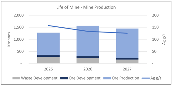
Note: Figure Prepared by First Majestic, April 2025.
| 1.11. | Recovery Methods |
The processing plant has been in operation for several years. The facility is divided into two primary areas: Plant No. 1, which includes the crushing and grinding circuits, and Plant No. 2, which contains the leaching circuit. The process utilizes cyanide tank leaching followed by Merrill-Crowe precipitation to produce silver doré bars from ground ROM ore. The crushing and grinding circuits are designed for 3,400 tonnes per day (“tpd”), while the leaching circuit has a capacity of 4,500 tpd.
ROM material is delivered to a 300-tonne steel coarse ore bin equipped with a grizzly feeder. Oversized material is sent to a primary jaw crusher, then combined with undersized material and conveyed to two primary vibrating screens. The crushing circuit operates 18 hours per day.
The grinding section features three ball mills with a nominal capacity of 3,400 tpd.
In the leaching circuit, cyanide and lime (as a pH modifier) are added to the slurry. Cyclone overflow is directed to a 125-foot primary thickener, whose underflow feeds 12 agitated leach tanks providing 50 hours of residence time (first leaching stage). Overflow from the last tank proceeds to an intermediate thickener, where the pregnant solution overflows and the underflow feeds a second leaching stage with five additional agitated tanks for a further 22 hours.
The pregnant leach solution (PLS) is clarified and filtered through three autojet pressure filters and stored in a 1,200 m³ tank before being deaerated and sent to three press filters. PLS production averages 18,000 m³/day at a grade of 17 g/t Ag. The resulting precipitate is dried and smelted in two induction furnaces, yielding 23-kg doré bars. The Merrill-Crowe system has a capacity of 550 kg doré per day.
| 12 | September 2025 |
| La Encantada Silver Mine Coahuila, Mexico NI 43-101 Technical Report on Mineral Resource and Mineral Reserve Estimates |
|
The CCD circuit consists of four 125-foot thickeners in series. Overflow and underflow streams are systematically recycled to maximize solution recovery. Final tailings are filtered through three press-filters and deposited in the filtered tailings storage facilities (FTSF).
In 2018, a roasting plant was added to reprocess tailings. However, operational issues during ramp-up, particularly in the cooling and materials handling stages, led to the circuit being placed on care and maintenance pending resolution.
| 1.12. | Infrastructure, Permitting and Compliance Activities |
The existing infrastructure at La Encantada can support current mining and mineral processing activities and the LOM plan.
Most of the operation’s support facilities are located near Plant No. 1 and include administrative offices, a medical clinic, warehouse, assay laboratory, core shed, fuel storage facilities, mine compressor building, surface maintenance shop, mine dry, water storage tanks and contractor offices. The mine camp is located approximately 1 km west of Plant No. 1 and the First Majestic-owned airstrip is approximately 6 km west of the mine camp.
Operations personnel are transported by passenger buses from the city of Muzquiz and the town of Ocampo. All equipment, supplies and materials are brought in by road.
The Waste Rock Storage Facilities (“WRSF”) consists of eight different storage locations. Waste Rock Storage Facilities No. 1 to 6 are active and located south, the Waste Rock Storage Facility No. 7 is inactive and located north, and Waste Rock Storage Facility No. 8 is active and located between the other locations. Filtered Tailings Storage Facility No. 5 (“FTSF-5”) is currently in operation and Filtered Tailings Storage Facility No.4 (“FTSF-4”) which is inactive. Rainwater management includes two main diversion channels. The current storage capacity of the FTSF 5 is 1.9 Mt of filtered tailings which represents 1.5 years at the current throughput rates. An Environmental Impact Manifestation (MIA) was received in late 2024 for an expansion of FTSF 5. The expansion adds 7.1 Mt taking the total capacity to 7.4 years of production, sufficient to support the LOM plan.
First Majestic’s camp facilities include 160 housing units for workers and staff with 440 beds, a new 180-person kitchen/dining area for salaried staff, accommodations for contractor managers and visitors, offices for union representatives, an elementary school, a chapel, a grocery store, and recreational facilities.
The electric power for the operation and supporting infrastructure is generated on-site. Additional rental portable generators are installed on an as needed basis. Power demand is currently 7.3 MW per month, which is being supplied by seven natural gas generators. Four 1.1 MW MTU units, one 1.9 MW CAT unit, and two 0.8 MW Siemens units.
Fresh water for the offices and employee housing is obtained from a well located in the underground mine. Industrial water for the mine and plant is obtained from a series of wells located 25 km away. This
| 13 | September 2025 |
| La Encantada Silver Mine Coahuila, Mexico NI 43-101 Technical Report on Mineral Resource and Mineral Reserve Estimates |
|
water is pumped to site and stored in a series of storage tanks located throughout the plant and mine facilities.
The La Encantada mine holds major environmental permits and licenses required by the Mexican authorities to carry out mineral extracting activities, such as an operating license for mining and mineral processing activities, a mine water use permit, an EIA for the La Encantada mine, processing plants and TMF, and a permit for power generation.
Major permits granted to La Encantada include: the environmental license (“LUA”), a groundwater use permit, a power generation permit, a change of land use for the industrial plant and Filtered Tailings Storage Facilities, an environmental impact assessment (“EIA”) for FTSF’s, an EIA for a roasting circuit and EIS for exploration.
On May 8, 2023, the Mexican Government enacted a decree amending several provisions of the Mining Law, the Law on National Waters, the Law on Ecological Equilibrium and Environmental Protection and the General Law for the Prevention and Integral Management of Waste (the “Decree”), which became effective on May 9, 2023. The Decree amends the mining and water laws, including: (i) the duration of the mining concession titles, (ii) the process to obtain new mining concessions (through a public tender). Additionally, on March 18, 2025, the new legislative framework for the hydrocarbon sector in Mexico was published in the Federal Official Gazette. This framework introduces specific permitting requirements for various hydrocarbons, including diesel.
These amendments are expected to have an impact on our current and future exploration activities and operations in Mexico, and the extent of such impact is yet to be determined but could be material for the Company. On June 7, 2023, the Senators of the opposition parties (PRI, PAN, and PRD) filed a constitutional action against the Decree, which is pending to be decided by Plenary of the Supreme Court of Justice.
During the second quarter of 2023, the Company filed an amparo lawsuit, challenging the constitutionality of the Decree. As of the date of this Technical Report, these amparos filed by First Majestic, along with numerous amparos in relation to the Decree that have been filed by other companies, are still pending before the District or Collegiate Courts. On July 15, 2024, the Supreme Court of Justice in Mexico suspended all ongoing amparo lawsuits against the Decree whilst the aforementioned constitutional action is being considered by the Supreme Court.
In February 2024, the La Encantada mine was distinguished as a Socially Responsible Company (“ESR”) by the Mexican Center for Philanthropy (“CEMEFI”) for the third consecutive year. The ESR award is given to companies operating in Mexico that achieve high performance and commitment to sustainable economic, social, and environmentally positive impact in all corporate life areas, including business ethics, engagement with the community, and preservation of the environment.
| 14 | September 2025 |
| La Encantada Silver Mine Coahuila, Mexico NI 43-101 Technical Report on Mineral Resource and Mineral Reserve Estimates |
|
| 1.13. | Capital and Operating Costs |
The La Encantada mine has a well-established cost management system and a good understanding of the costs of operation. Relevant key-performance indicators are compiled and analyzed on a monthly basis to monitor operational performance, analyze financial results, and prepare economic projections.
The LOM plan includes estimates for sustaining capital expenditures for the planned mining and processing activities. Sustaining capital expenditures are allocated for on-going development in waste, infill drilling, mine equipment rebuilding, equipment overhauls or replacements, plant maintenance and on-going refurbishing. Table 1-5 presents the summary of the sustaining and expansionary capital expenditures.
Table 1-5: La Encantada Mining Capital Costs Summary (Sustaining Capital)
| Type(M USD) |
Total |
2025 |
2026 |
2027 |
||||||||||||
| Mine Development |
$ | 16.6 | $ | 5.6 | $ | 5.6 | $ | 5.4 | ||||||||
| Property, Plant & Equipment |
$ | 12.4 | $ | 4.2 | $ | 4.2 | $ | 4.0 | ||||||||
| Other Sustaining Costs |
$ | 4.1 | $ | 1.3 | $ | 1.6 | $ | 1.2 | ||||||||
|
|
|
|
|
|
|
|
|
|||||||||
| Total Sustaining Capital Costs |
$ | 33.0 | $ | 11.0 | $ | 11.4 | $ | 10.7 | ||||||||
|
|
|
|
|
|
|
|
|
|||||||||
| Near Mine Exploration |
$ | 1.5 | $ | 0.5 | $ | 0.5 | $ | 0.5 | ||||||||
|
|
|
|
|
|
|
|
|
|||||||||
| Total Capital Costs |
$ | 34.6 | $ | 11.5 | $ | 11.9 | $ | 11.2 | ||||||||
|
|
|
|
|
|
|
|
|
|||||||||
A summary of the La Encantada operating costs resulting from the LOM plan and the economic model used for assessing economic viability is presented in Table 1-6. A summary of the annual operating expense is presented in Table 1-7.
Table 1-6: La Encantada Operating Costs
| Type |
$/tonne milled |
|||
| Mining Cost |
15 | |||
| Processing Cost |
20.7 | |||
| Indirect Costs |
13.4 | |||
|
|
|
|||
| Total Production Cost |
49.1 | |||
|
|
|
|||
| Selling Cost |
0.8 | |||
|
|
|
|||
| Total Cash Cost |
49.9 | |||
|
|
|
|||
Table 1-7: La Encantada Annual Operating Costs
| Type (M USD) |
Total | 2025 | 2026 | 2027 | ||||||||||||
| Mining Cost |
$ | 52.8 | $ | 17.7 | $ | 17.9 | $ | 17.2 | ||||||||
| Processing Cost |
$ | 72.7 | $ | 24.4 | $ | 24.6 | $ | 23.7 | ||||||||
| Indirect Costs |
$ | 47.2 | $ | 15.8 | $ | 16.0 | $ | 15.4 | ||||||||
|
|
|
|
|
|
|
|
|
|||||||||
| Total Production Cost |
$ | 172.7 | $ | 58.0 | $ | 58.4 | $ | 56.3 | ||||||||
|
|
|
|
|
|
|
|
|
|||||||||
| Selling Costs |
$ | 2.7 | $ | 0.9 | $ | 0.9 | $ | 0.9 | ||||||||
|
|
|
|
|
|
|
|
|
|||||||||
| Total Cash Cost |
$ | 175.5 | $ | 58.9 | $ | 59.3 | $ | 57.2 | ||||||||
|
|
|
|
|
|
|
|
|
|||||||||
| 15 | September 2025 |
| La Encantada Silver Mine Coahuila, Mexico NI 43-101 Technical Report on Mineral Resource and Mineral Reserve Estimates |
|
| 1.14. | Conclusions |
Under the assumptions used in this Technical Report, La Encantada has positive economics for the LOM plan, which supports the Mineral Reserve statement.
| 1.15. | Recommendations |
Qualified Persons recommend a two-phase program of work. Activities in Phase 2 are contingent upon the successful completion of corresponding activities in Phase 1.
| • | Phase 1 – Exploration consists of a recommended annual 9,000-meter drilling program, comprising 1,000 meters of infill drilling for short-term production, 4,000 meters of near-mine drilling for mid-term projections, and 4,000 meters of brownfield surface drilling to identify additional resources. The drilling program is estimated to cost $1.2 million per year, excluding underground access development costs. An additional $200,000 per year is allocated for a prospect generation program that includes prospecting, mapping, geochemical, and geophysical surveys. These exploration efforts are part of a multi-year plan and should be reviewed annually. The total estimated expenditure for Phase 1 is $1.4 million per year, or approximately $7.2 million over five years. |
| • | Phase 2 – Roasting involves capital upgrades to the existing, inoperative roasting circuit. The estimated cost of the required improvements ranges from $20 million to $30 million. Ongoing study and process optimization are recommended to potentially reduce capital expenditures and enhance cost-efficiency. Phase 2 will proceed only if supported by the outcomes of Phase 1. It is recommended to continue exploring opportunities to reduce capital costs and optimize the process to achieve a more cost-effective solution. |
The proposed work can be carried out concurrently, with a total estimated expenditure across both phases ranging from $21.2 million to $31.2 million.
| 16 | September 2025 |
| La Encantada Silver Mine Coahuila, Mexico NI 43-101 Technical Report on Mineral Resource and Mineral Reserve Estimates |
|
| 2. | INTRODUCTION |
| 2.1. | Technical Report Issuer |
La Encantada Silver Mine (La Encantada, the La Encantada mine) is owned and operated by Minera La Encantada S.A de C.V. (MLE) which is an indirectly wholly owned subsidiary of First Majestic Silver Corp. (First Majestic). First Majestic acquired control of La Encantada through the acquisition of all issued and outstanding common shares of Desmin S.A. de C.V. (Desmin) on November 1, 2006, followed by the 100% acquisition of MLE from Industrias Peñoles, S.A.B. de C.V. (Peñoles) in March 2007.
La Encantada operations consist of an operating underground mine, two processing plants and two Filtered Tailings Storage Facilities (FTSF), one active, one inactive.
| 2.2. | Terms of Reference |
This Technical Report provides information on Mineral Resource and Mineral Reserve estimates for La Encantada and describes process operations and planning for the mine. The Mineral Resource and Mineral Reserve estimates are reported in accordance with the Canadian Institute of Mining, Metallurgy and Petroleum (CIM) Definition Standards for Mineral Resources and Mineral Reserves (May 2014; the 2014 CIM Definition Standards).
| 2.3. | Cut-off and Effective Date |
The effective date of the Mineral Resource and Mineral Reserve estimates presented in this Technical Report is December 31, 2024, which represents the cut-off date for the most relevant scientific and technical information used in the Technical Report for such estimates. The effective date for this Technical Report is August 31, 2025.
In the opinion of the undersigned Qualified Person(s), the scientific and technical information contained in this Technical Report is current as of the Technical Report’s effective date. The Mineral Resource and Mineral Reserve estimates are supported by data and interpretations valid as of December 31, 2024, and no material changes have occurred between that date and the Technical Report’s effective date that would impact the conclusions herein.
| 2.4. | Qualified Persons |
The Qualified Persons (“QP”) for this Technical Report are employees of First Majestic. The QPs are Gonzalo Mercado, P.Geo., Vice President of Exploration and Technical Services, Karla Michelle Calderon Guevara, CPG, Senior Resource Geologist, Michael Jarred Deal, RM SME, Vice President of Metallurgy &
| 17 | September 2025 |
| La Encantada Silver Mine Coahuila, Mexico NI 43-101 Technical Report on Mineral Resource and Mineral Reserve Estimates |
|
Innovation, Andrew Pocock, P.Eng., Director of Reserves, and Ms. María Elena Vázquez Jaimes, P. Geo., Geological Database Manager.
| 2.5. | Site Visits |
Mr. Mercado visited La Encantada on numerous occasions during 2021 to 2024, with the most recent visit being October 22 to 23, 2024. During the inspections which were typically 2 days in duration, he visited the underground mines, reviewed grade control mapping and sampling, drilling and drill sample practices, project geology, logging as well as mine to mill reconciliation.
Ms. Calderon Guevara worked full-time at La Encantada from 2017 to 2020, and since then she has been visited on several occasions with the most recent visit and inspection being from December 3rd to 9th, 2024. During these site inspections she reviewed and coordinated database management, data validation, project geology, drilling, core handling and logging, mine geology, interpretation, and integration of primary data for geological interpretation and modeling, and the Mineral Resource estimation process.
Ms. Vázquez Jaimes visited the La Encantada mine on several occasions from 2021 to 2023, with the most recent site visit being March 5th to March 9th. During these visits, she conducted database audits and inspected drill core handling procedures to support Mineral Resource estimates. During the most recent visit, she conducted validation and verification of the resource estimation database, assessment of the quality assurance and quality control (QAQC) data, validation of core logging and sampling procedures, and inspection of samples storage.
Mr. Deal has been involved with the La Encantada Mine since 2023, overseeing all processing and metallurgical activities. He visited the site on two occasions during 2024, with the most recent visit taking place in October 2024. Each site visit focused on reviewing processing operations, metallurgical testing programs and results, assay laboratory procedures, maintenance practices, and the status of key process-related projects. These inspections provided direct insight into plant performance, operational challenges, and continuous improvement initiatives, contributing to the ongoing optimization of metallurgical recoveries and plant efficiency.
Mr. Pocock has been involved with the La Encantada Mine since 2024 overseeing, consulting, and supporting technical and operational aspects including civil engineering related to tailings management and processing, environmental permitting and compliance, interim reclamation and closure, and reclamation planning and budgets.
| 2.6. | Sources of Information |
For the purposes of the Technical Report, all information, data, and figures contained or used in its integration have been provided by First Majestic unless otherwise stated. Information sources are listed in Section 27 of this Technical Report.
| 18 | September 2025 |
| La Encantada Silver Mine Coahuila, Mexico NI 43-101 Technical Report on Mineral Resource and Mineral Reserve Estimates |
|
Exploration and infill drilling are ongoing. Where applicable, results received to date from this recent drilling activity have generally supported the current resource models. The QPs for this Technical Report have reviewed the latest information available from the effective date for the Mineral Resource and Mineral Reserve Estimates to the effective date for the Technical Report and there are no material changes to the information provided in this Technical Report.
| 2.7. | Previously Filed Technical Reports |
Previously filed technical reports and studies include the following:
| • | La Encantada Silver Mine, Coahuila, Mexico, NI 43-101 Technical Report on Mineral Resource and Mineral Reserve Estimates, dated December 31, 2020. Prepared by Ramón Mendoza Reyes, P.Eng., David Rowe, CPG., María Elena Vázquez Jaimes, P.Geo., Brian Boutilier, P.Eng., Persio P. Rosario, P.Eng. |
| • | NI 43-101 Technical Report on Mineral Resource and Mineral Reserve Update, La Encantada Silver Mine, Ocampo, Coahuila, Mexico, dated December 31, 2015. Prepared for First Majestic Silver Corp. by Mendoza Reyes, R., Vázquez Jaimes, M.E., Velador Beltran, J., and Oshust P. |
| • | Technical Report for the La Encantada Silver Mine, Coahuila State, Mexico, amended and restated February 26, 2009. Prepared for First Majestic Silver Corp. by Addison, R. and Lopez L., of Pincock, Allen & Holt. |
| • | Technical Report for the La Encantada Silver Mine, Coahuila State, Mexico, dated July 24, 2007. Prepared for First Majestic Silver Corp. by Addison, R. and Lopez, L. of Pincock, Allen & Holt. |
| 2.8. | Units and Currency and Abbreviations |
Units of measurement are metric unless otherwise noted. All costs are expressed in United States dollars unless otherwise noted. Only common and standard abbreviations are used wherever possible. Table 2-1 shows the list of abbreviations used.
| 19 | September 2025 |
| La Encantada Silver Mine Coahuila, Mexico NI 43-101 Technical Report on Mineral Resource and Mineral Reserve Estimates |
|
Table 2-1: List of Abbreviations and Units
| Distances: | mm – millimetre | Other: | tpd – tonnes per day | |||
|
cm – centimetre
m – metre
km – kilometre
ft – foot |
ktpd – 1,000 tonnes per day
Mtpa – 1,000,000 tonnes per year
kW – kilowatt
MW – megawatt |
|||||
|
Areas: |
m2 – square metre
ha – hectare
km2 – square kilometre |
kVA – kilovolt-ampere
MVA – Megavolt-ampere
kWh – kilowatt hour |
||||
|
Weights: |
oz – troy ounces
koz – 1,000 troy ounces
Moz – million troy ounces
lb – pound
g – grams
kg – kilograms
t – tonne (1,000 kg)
kt – 1,000 tonnes
Mt – 1,000,000 tonnes |
MWh – megawatt hour
°C – degrees Celsius
Ag – silver
Au – gold
Pb – lead
Zn – zinc
Cu – copper
Mn – manganese
Ag-Eq – silver equivalent
masl – metres above sea level |
||||
|
Time: |
min – minute
hr – hour
op hr – operating hour
d – day
yr – year |
Assay/Grade: |
g/t – grams per tonne
g/L – grams per litre
ppm – parts per million
ppb – parts per billion |
|||
| Currency: |
$ – United States dollar | |||||
|
Volume/Flow: |
m3– cubic metre
m3/hr – cubic metres per hour
gpm – gallons per minute (water)
cfm – cubic feet per minute (air)
cu yd – cubic yards |
|||||
| 20 | September 2025 |
| La Encantada Silver Mine Coahuila, Mexico NI 43-101 Technical Report on Mineral Resource and Mineral Reserve Estimates |
|
| 3. | RELIANCE ON OTHER EXPERTS |
This section is not relevant to this Technical Report. Information pertaining to mineral tenure, surface rights, royalties, environment, permitting and social considerations, marketing and taxation were sourced from First Majestic experts in those fields as required.
| 21 | September 2025 |
| La Encantada Silver Mine Coahuila, Mexico NI 43-101 Technical Report on Mineral Resource and Mineral Reserve Estimates |
|
| 4. | PROPERTY DESCRIPTION AND LOCATION |
| 4.1. | Location |
La Encantada is an actively producing mine located in the municipality of Ocampo, State of Coahuila, northern Mexico, approximately 120 km northwest of the city of Melchor Múzquiz, Coahuila and approximately 120 km north of the town of Ocampo, Coahuila (Figure 4-1). The mine portal is located at approximately 102°32’10” W Longitude and 28°22’13” N Latitude, at an elevation of approximately 1,775 metres above sea-level (masl).
Figure 4-1: Location Map of La Encantada Silver Mine
Note: Figure prepared by First Majestic, August 2025.
| 4.2. | Ownership |
In 1967, Industrias Peñoles, S.A.B. de C.V. (Peñoles) and Tormex established a joint venture partnership (Minera La Encantada) to acquire and develop La Encantada. In July 2004, Peñoles awarded a contract to operate the La Encantada mine, including the processing plant and all mine infrastructure facilities, to the private Mexican company Desmin, S.A. de C.V (Desmin). Desmin operated the mine and processing plant until November 1, 2006, when First Majestic purchased all the outstanding shares of Desmin.
| 22 | September 2025 |
| La Encantada Silver Mine Coahuila, Mexico NI 43-101 Technical Report on Mineral Resource and Mineral Reserve Estimates |
|
Subsequently, First Majestic reached an agreement to acquire all the outstanding shares of MLE from Peñoles.
First Majestic is now the sole owner of La Encantada and all its assets, including mineral rights, surface rights position, water rights, processing plants and ancillary facilities.
| 4.3. | Mining Tenure |
In Mexico, mining concessions are granted by the General Mining Directorate of the Ministry of Economy, and these are considered exploitation concessions with a 50-year term. Mining concessions have an annual minimum investment to complete, and an annual mining rights fee to be paid to keep the concessions effective. Valid mining concessions can be renewed for an additional 50-year term as long as the mine is active. There are 22 granted concessions, which cover an area of 4,076 ha, located within the municipalities of Ocampo and Múzquiz in the State of Coahuila. All 22 concessions are currently in good standing. Table 4-1 lists the concessions, the concession area, and current expiration dates. Concession locations are shown in Figure 4-2.
Table 4-1: List of Minera La Encantada Mining Concessions
| No. |
Mining Concession |
Title | Expiry Date | Surface | Status | |||||||||||||
| Hectares | ||||||||||||||||||
| 1 | ENCANTADA | 143943 | 26-Aug-65 | 75 | Valid | |||||||||||||
| 2 | EL PAJARITO | 167061 | 28-Aug-30 | 9 | Valid | |||||||||||||
| 3 | MONTECARLO | 167062 | 28-Aug-30 | 9 | Valid | |||||||||||||
| 4 | EL TIGRE | 167065 | 28-Aug-30 | 41 | Valid | |||||||||||||
| 5 | EL CAMELLO | 167066 | 28-Aug-30 | 75 | Valid | |||||||||||||
| 6 | LOS ANGELES | 167067 | 28-Aug-30 | 20 | Valid | |||||||||||||
| 7 | AMPL. DE LOS ANGELES | 167068 | 28-Aug-30 | 27.23 | Valid | |||||||||||||
| 8 | EL GRANIZO | 167069 | 28-Aug-30 | 25 | Valid | |||||||||||||
| 9 | LA PRESITA | 167070 | 28-Aug-30 | 25 | Valid | |||||||||||||
| 10 | REGALADO | 167071 | 28-Aug-30 | 100 | Valid | |||||||||||||
| 11 | EL GOLPE 10 | 178385 | 6-Aug-36 | 40 | Valid | |||||||||||||
| 12 | ROSITA No. 19 | 189752 | 5-Dec-40 | 79.95 | Valid | |||||||||||||
| 13 | LOS ANGELITOS | 189758 | 5-Dec-40 | 27.23 | Valid | |||||||||||||
| 14 | LOS ANGELITOS 2 | 189759 | 5-Dec-40 | 27.23 | Valid | |||||||||||||
| 15 | LOS ANGELITOS 3 | 190341 | 5-Dec-40 | 16 | Valid | |||||||||||||
| 16 | LA PRESITA 10 | 194878 | 29-Jul-42 | 100 | Valid | |||||||||||||
| 17 | SAN JAVIER | 217855 | 26-Aug-52 | 3.02 | Valid | |||||||||||||
| 18 | LAS ROSITAS | 227288 | 1-Jun-56 | 287 | Valid | |||||||||||||
| 19 | ROSITA 2 | 230228 | 1-Aug-57 | 350 | Valid | |||||||||||||
| 20 | ROSITA 1 | 232026 | 9-Jun-58 | 50 | Valid | |||||||||||||
| 21 | ROSITA 3 | 232027 | 9-Jun-58 | 850 | Valid | |||||||||||||
| 22 | PLATON | 232832 | 29-Oct-58 | 1,839.26 | Valid | |||||||||||||
| 23 | September 2025 |
| La Encantada Silver Mine Coahuila, Mexico NI 43-101 Technical Report on Mineral Resource and Mineral Reserve Estimates |
|
Figure 4-2: Minera La Encantada Mining Concessions
Note: Figure prepared by First Majestic, August 2025.
As per Mexican requirements for grant of tenure, the concessions comprising the La Encantada claims have been surveyed on the ground by a licensed surveyor.
All applicable payments and reports have been submitted to the relevant authorities, and the licenses are in good standing as at the Technical Report effective date.
| 4.4. | Royalties |
In 2013, the Mexican Federal government introduced a mining royalty, effective January 1, 2014, based on 7.5% of taxable earnings before interest and depreciation. In addition, precious metal mining companies must pay a 0.5% royalty on revenues from gold, silver, and platinum. In 2025, the Mexican Federal Government amended the law and increased the rights from 7.5% to 8.5% of the taxable earnings before interest and depreciation and from 0.5% to 1% royalty on revenues from gold, silver, and platinum.
| 24 | September 2025 |
| La Encantada Silver Mine Coahuila, Mexico NI 43-101 Technical Report on Mineral Resource and Mineral Reserve Estimates |
|
La Encantada has a royalty agreement in place with Royalty & Streaming Mexico SA de CV, (owned by Metalla Royalty & Streaming Ltd, consisting of the 100% gross overriding royalty from gold production on the first 1,000 payable ounces annually.
| 4.5. | Surface Rights |
Surface rights in the area of the mining concessions are held both privately and through group ownership either as communal lands or Ejido lands.
According to deeds, MLE owns surface rights covering 2,237 ha on the “Canon del Regalado” properties. These properties were acquired by the previous owner of MLE from a third party. This surface covers the following features: access to the mining complex, mine portals, grinding mill and flotation plant (Plant No. 1), cyanidation plant (Plant No. 2), TMF, the mine camp, offices, and an airstrip.
In 2011 the Tenochtitlán Ejido filed a lawsuit against MLE in agrarian court claiming title to 1,097 ha of the land owned by MLE. The initial lawsuit was decided in favour of MLE and was followed by a series of motions and appeals regarding judicial reviews of the subsequent rulings. Resumption of the initial lawsuit regarding the land title is currently pending a judicial review ruling. MLE has strengthened its relationship with the Tenochtitlán Ejido through ongoing dialogue and is working toward reaching an amicable settlement outside of court. Should Tenochtitlan Ejido obtain a resolution in their favour, negotiations will be needed for compensation of the 1,097 ha.
MLE also holds 19,114 ha of surface rights consisting of the “Cielo Norteño” property to the northeast of the mine covering an area with water rights. Figure 4-3 shows the map of La Encantada Surface Rights.
| 25 | September 2025 |
| La Encantada Silver Mine Coahuila, Mexico NI 43-101 Technical Report on Mineral Resource and Mineral Reserve Estimates |
|
Figure 4-3: Map of Minera La Encantada Surface Rights
Note: Figure prepared by First Majestic August 2025.
| 4.6. | Permits |
MLE holds major environmental permits and licenses required by the Mexican authorities to carry out mineral extracting activities in the mining complex. Details of the permits held in support of operations are discussed in Section 20 of this Technical Report.
| 4.7. | Environmental Considerations |
Environmental considerations are discussed in Section 20 of this Technical Report.
| 4.8. | Existing Environmental Liabilities |
Environmental liabilities for the operation are typical of those that would be expected to be associated with an operating underground precious metals mine, including the future closure and reclamation of mine portals and ventilation infrastructure, access roads, processing facilities, power lines, filtered tailings storage facilities (FTSF) and all surface infrastructure that supports the operations.
Additional information on environmental matters is provided in Section 20 of this Technical Report.
| 26 | September 2025 |
| La Encantada Silver Mine Coahuila, Mexico NI 43-101 Technical Report on Mineral Resource and Mineral Reserve Estimates |
|
| 4.9. | Factors and Risks |
To the extent known to the QPs, there are no other significant factors and risks that may affect access, title, or the legal right or ability to perform work at La Encantada that are not discussed in this Technical Report.
| 27 | September 2025 |
| La Encantada Silver Mine Coahuila, Mexico NI 43-101 Technical Report on Mineral Resource and Mineral Reserve Estimates |
|
| 5. | ACCESSIBILITY, CLIMATE, LOCAL RESOURCES, INFRASTRUCTURE AND PHYSIOGRAPHY |
The La Encantada mine is located approximately 500 km north of the city of Torreon and 220 km northeast of the city of Muzquiz by road, and although in a remote location, it is accessible year-round. The city of Muzquiz is connected to the national highway system.
| 5.1. | Accessibility |
Access to La Encantada is primarily by charter airplane from Durango city (about two hours flying time), or from the city of Torreón, Coahuila (about 1:15 hours flying time). MLE operates its own private airstrip at the La Encantada mine. The airstrip is paved, 1,200 m long by 17 m wide, and is located at 1,300 masl.
Road access from the city of Muzquiz is via a 150 km paved road and another 70 km of gravel road. Driving time from the city of Múzquiz is approximately 2.5 hours, about five hours from the town of Ocampo and about eight hours from the international airport in Torreón city. The mine can be accessed and operated all-year round. Figure 5-1 shows the road access route to La Encantada.
Figure 5-1: Access to La Encantada
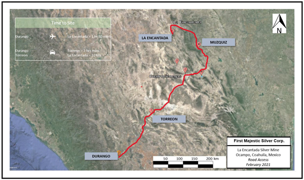
Note: Figure prepared by First Majestic, First Majestic August 2025.
| 28 | September 2025 |
| La Encantada Silver Mine Coahuila, Mexico NI 43-101 Technical Report on Mineral Resource and Mineral Reserve Estimates |
|
| 5.2. | Physiography |
La Encantada is located in the northern part of the Sierra Madre Oriental (SMO) physiographic province in a mountain range that corresponds to a symmetrical anticline (La Encantada Range). The La Encantada mountain range runs for about 45 km in the northwest–southeast direction and has elevations that vary from about 1,500 m to over 2,400 m.
| 5.3. | Climate |
La Encantada lies within a semi-hot and dry desert region and annual average temperatures typically range from 10–22°C, reaching highs of 30°C and lows of 2°C. Days with recorded freezing temperatures range from 20 to 40 days during the year. Annual average rainfall varies from 10–400 mm with most of the rain occurring during the summer months in short rainstorms. The predominant wind direction is from the northeast.
| 5.4. | Local Resources and Infrastructure |
La Encantada’s remote location has required the construction of substantial infrastructure, which has been developed during an extended period of active operation by First Majestic and the mine’s previous owners, Peñoles and Compañía Minera Los Angeles, S.A. de C.V. (Compañía Minera Los Angeles).
Power supply to the mine, processing facilities and camp site is from diesel and liquified natural gas generators operated for First Majestic by a contractor. First Majestic also provides the potable water supply. First Majestic has installed a satellite communication system with internet. Handheld radios are carried by supervisors, managers, and vehicle operators for communication. Most f the supplies and labour required for the operation are sourced from the cities of Múzquiz, Sabinas and Monclova Coahuila, or directly from suppliers.
Additional information on the Project infrastructure is provided in Section 18 of this Technical Report.
| 29 | September 2025 |
| La Encantada Silver Mine Coahuila, Mexico NI 43-101 Technical Report on Mineral Resource and Mineral Reserve Estimates |
|
| 6. | HISTORY |
Exploration activities in the Encantada were initiated in 1956 by Compañía Minera Los Angeles. In 1956, the San José and Guadalupe deposits located to the north of the Escondida breccia pipe deposit were discovered and developed, and the related underground operation was known as the El Plomo mine. At the end of 1956, the San Francisco Vein was discovered, and in 1957 mining commenced on the 800, El Socorro and 8-de-Enero deposits. In 1963, the of the Prieta complex deposits were discovered as well as areas of the San Javier complex.
In 1967, Peñoles and Tormex established a joint venture partnership (Minera La Encantada) to acquire and develop La Encantada. A magnetic-separation plant was installed in July 1973 and replaced five years later by a flotation processing plant. The Cuerpo 660 high-grade silver massive lens replacement zone between the 635 and 710 levels was discovered in the Prieta complex in 1967, together with irregular replacement bodies and vein-type deposits.
In July 2004, Peñoles awarded a contract to operate the La Encantada mine, including the processing plant and all mine infrastructure facilities, to Desmin. Desmin operated the mine and processing plant at approximately 25% capacity until November 1, 2006, when First Majestic purchased all the outstanding shares of Desmin. Subsequently, First Majestic reached an agreement to acquire all the outstanding shares of MLE from Peñoles.
From November 2006 to June 2010, First Majestic operated a 1,000 tpd flotation plant which was refurbished after the Desmin purchase. All production during this period was from the flotation plant and was in the form of a lead–silver concentrate.
Construction of a 3,750 tpd cyanidation plant commenced in July 2008. Full production capacity was reached in the fourth quarter of 2010. During 2011, several modifications were made to the cyanidation plant increasing its capacity to 4,000 tpd. Commencing in November 2009, the cyanidation plant began producing precipitates and silver doré bars. The flotation circuit was placed on care-and-maintenance in June 2010, except for the crushing and grinding areas, which remain in operation. Since that time, the La Encantada operation has been producing only doré bars.
In December 2014, First Majestic began a plant expansion initiative to increase the crushing and grinding capacity to 3,000 tpd. A new ball mill, a tertiary crusher, two vibrating screens and a series of conveyor belts were installed. The plant expansion was completed by the end of May 2015 allowing for the ramp up to 3,000 tpd in July 2015.
The Esperanza decline was excavated to access the Prieta complex since the caving method that was to be used in the area was expected to damage the old Peñoles shaft and isolate the mining area from surface. In March 2018, the first caving blast was performed, and a constant production was achieved in the end of third quarter of 2018. The Esperanza ramp reached the Prieta complex in October 2018 and mining continues there today.
| 30 | September 2025 |
| La Encantada Silver Mine Coahuila, Mexico NI 43-101 Technical Report on Mineral Resource and Mineral Reserve Estimates |
|
| 6.1. | Production History |
Mine production figures since 2014 in tonnes and ounces of silver are presented in Figure 6-1.
Figure 6-1: Mine and Silver Production since 2014
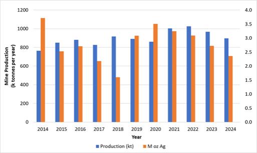
Note: Figure prepared by First Majestic, April 2025.
| 31 | September 2025 |
| La Encantada Silver Mine Coahuila, Mexico NI 43-101 Technical Report on Mineral Resource and Mineral Reserve Estimates |
|
| 7. | GEOLOGICAL SETTING AND MINERALIZATION |
| 7.1. | Regional Geology and Stratigraphy |
La Encantada is located in the Sierra La Encantada, a northwest-trending mountain range, located in the northern part of Coahuila within the Sierra Madre Oriental fold and thrust belt. The SMO extends in a south–southeasterly direction for about 1,500 km, between longitudes 101°W and 108°W from the U.S.–Mexican border in the north to latitude 20°N in the south. In Coahuila, the SMO encompasses wide flat alluvial plains separated by long narrow north–south to west–northwest-trending ranges.
The tectonic and stratigraphic basement consists of a mosaic of tectono-stratigraphic terranes bounded by mapped and interpreted shears or sutures. The names “Coahuila” or “Coahuiltecano” terrane were proposed by Campa and Coney (1983) and Sedlock et al. (1993), respectively, for the Paleozoic basement of the northeastern portion of Mexico beneath most of the states of Coahuila, Nuevo León, and Tamaulipas. Figure 7-1 shows the SMO province and the Coahuiltecano terrane and other terranes of Mexico as defined by Sedlock et al. (1993).
Figure 7-1: Map of Mexico Showing the SMO Physiography and location of La Encantada Silver Mine
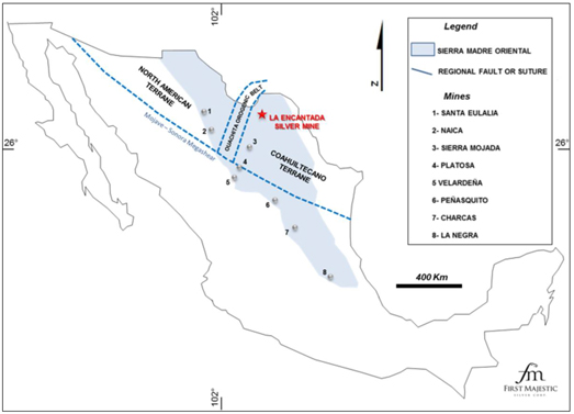
Note: Regional mines shown are operated by third parties. Figure prepared by First Majestic, April 2025.
| 32 | September 2025 |
| La Encantada Silver Mine Coahuila, Mexico NI 43-101 Technical Report on Mineral Resource and Mineral Reserve Estimates |
|
The Coahuiltecano terrane consists of Paleozoic low-grade metamorphic rocks, and Paleozoic arc-derived flysch and arc-related volcanic rocks that were intruded by Triassic calc-alkalic plutons and overlapped by Late Jurassic and Cretaceous platform rocks that cover most of the terrane.
Paleogeographic features that were relevant for the post-Paleozoic stratigraphic and tectonic evolution of the region include the Burro-Peyotes Peninsula, the Coahuila Block, and the Sabinas Basin. The Sabinas Basin is a graben limited by the Coahuila Block to the south, and the Burro–Peyotes peninsula to the north. Formation of the Sabinas Basin began in the Permo–Triassic during the Ouachita–Maraton orogeny. Reactivation of the San Marcos fault in the Late Jurassic accommodated north–northeast crustal extension and contributed to the development and growth of the basin (Chavez-Cabello et al., 2007). The San Marcos fault is a 300 km long crustal structure that separates the Coahuila block from the Coahuila fold belt.
During the Jurassic and Cretaceous, development of the Sabinas Basin, a ~6,000 m-thick sequence of siliciclastic, carbonate, and evaporite sediments were deposited unconformably on the Coahuiltecano terrane (González-Sánchez et al., 2009). Sabinas Basin carbonate rocks, including the Lower-Upper Cretaceous Cupido, La Peña and Aurora Formations, host mineralization at La Encantada and other mines and prospects in the region.
Northeast–southwest oriented compression during the Cretaceous to early Tertiary Laramide Orogeny deformed the Mesozoic sedimentary rocks into a series of north–northwest-trending folds and faults, which gave rise to the SMO, i.e., the Mexican fold thrust belt. Extension in the mid to late Tertiary reactivated and reopened Laramide age and older faults, including the structures bounding the Coahuila platform and the Burro-Peyotes peninsula (San Marcos and La Babia faults, respectively), and developed further northwest–southeast oriented faults.
The mid-Tertiary extensional deformation was accompanied by widespread magmatism, with the related fault zones acting as conduits for the emplacement of shallow level intrusive rocks within the carbonate sedimentary sequence (granitic, monzonitic and granodioritic stocks). Some intrusions produced skarn-related mineralization where in contact with Cretaceous limestones and were later exposed by erosion due to widespread uplift and block faulting during the Pliocene.
| 7.2. | Regional Structure |
The SMO is made up of north- and northwest-trending anticlinal ranges and faults that formed during the Laramide Orogeny between the Late Cretaceous and Early Tertiary. Pre-existing structures cutting through the Paleozoic basement of Northern Mexico were probably reactivated during the Laramide Orogeny and during post-Laramide, Eocene–Oligocene extensional tectonics. Two major crustal structures were important in the formation and growth of the Sabinas Basin: the northwest-trending San Marcos fault to the south, separating the Coahuila block from the Sabinas Basin, and the northwest-trending La Babia fault to the north, which separated the Burro-Peyotes peninsula from the basin (Figure 7-2).
| 33 | September 2025 |
| La Encantada Silver Mine Coahuila, Mexico NI 43-101 Technical Report on Mineral Resource and Mineral Reserve Estimates |
|
Figure 7-2: Map of Northern Coahuila Showing the Sabinas Basin and the Regional La Babia and San Marcos Faults
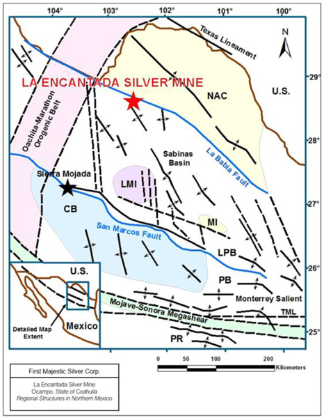
Note: Figure prepared by First Majestic, April 2025.
Crustal scale structures are interpreted as favorable structural settings for the localization of mineral deposits, and La Encantada lies along the projection of the La Babia fault-lineament. Examples of other deposits along the major crustal faults include Sierra Mojada, which lies right on the San Marcos Fault, and Platosa lying along a major northwest-trending structure on the western margin of the Coahuila block (Stockhausen, 2012, Megaw et al., 1988). Other important districts such as Santa Eulalia and Naica lie in a similar structural setting within the Chihuahua trough (Ruiz et al., 1986; Megaw et al., 1988).
| 34 | September 2025 |
| La Encantada Silver Mine Coahuila, Mexico NI 43-101 Technical Report on Mineral Resource and Mineral Reserve Estimates |
|
| 7.3. | Local Geology and Stratigraphy |
The stratigraphic section at La Encantada consists of marine sedimentary rocks that were deposited in the Sabinas Basin between the Lower Cretaceous and the Upper Cretaceous. The base of the stratigraphic section consists of the Early Aptian age Cupido Formation. The Cupido Formation consists of thin-bedded limestones and dolostones that have rarely been intersected by deep drill holes. The formation crops out outside the Project area in the La Vasca range approximately 30 km northwest of the mine.
The approximately 200 m thick La Peña Formation of Late Aptian age overlays the Cupido Formation and consists of thin-bedded black shales interlayered with black bituminous carbonaceous limestones (Lozano, 1981).
Conformably overlying the La Pena Formation is the 452 m thick Early-Middle Albian Aurora Formation, which is the primary host rock for mineralization at La Encantada. The lower unit consists of medium to massive bedded calcilutites and minor calcarenites, becoming more distinctively medium-bedded calcispaerula bearing to locally cherty calcisiltites in the upper section (Lozej and Beals, 1977; Lozano, 1981). The middle of the limestone sequence consists of dense, thick-bedded, grayish calcilutite, which forms distinctive cliff faces at La Encantada. The upper Aurora Formation consists of medium to thin bedded limestone. Figure 7-3 shows a view of the Encantada range front exposures of the Aurora Formation.
Figure 7-3: Panoramic View of La Encantada Range Front Exposing the Aurora Formation
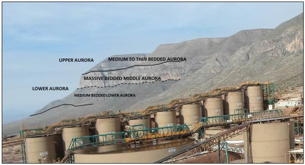
Note: Looking North. Figure prepared by First Majestic, April 2025.
| 35 | September 2025 |
| La Encantada Silver Mine Coahuila, Mexico NI 43-101 Technical Report on Mineral Resource and Mineral Reserve Estimates |
|
Conformably overlying the Aurora Formation is the middle Albian-lower Cenomanian age Cuesta del Cura Formation. This distinctive thin-bedded limestone consists of 250–350 metres of oolitic limestones with abundant chert nodules and lenses.
Thin-bedded alternating shales and limestones of the Del Rio Formation, and medium-bedded limestones correlating to the Buda Formation conformably overlie the Cuesta del Cura Formation; their precise thicknesses in the mine area are unknown, but estimated thicknesses are approximately 45 m for the Del Rio Formation and 100 m for the Buda Formation (Diaz, 1987). Figure 7-4 is a property geological map showing the main outcropping units and structures, and Figure 7-5 is a stratigraphic column for the area.
Figure 7-4: Geological Map of La Encantada Property
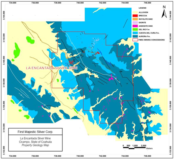
Note: Figure prepared by First Majestic, April 2025.
| 36 | September 2025 |
| La Encantada Silver Mine Coahuila, Mexico NI 43-101 Technical Report on Mineral Resource and Mineral Reserve Estimates |
|
Figure 7-5: Stratigraphic Column for La Encantada
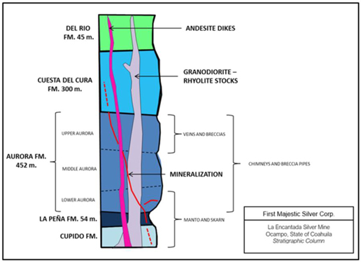
Note: Figure prepared by First Majestic, April 2025. FM = formation.
A granodiorite stock and rhyolite to basalt dikes of Eocene–Oligocene age intrude the Cretaceous carbonate rocks. The granodiorite is intersected in drill-holes within the La Prieta complex and in underground developments and drill holes at the San Javier–Milagros complex. The intrusion consists of feldspar, quartz, and ferromagnesian minerals (hornblende), and commonly shows retrograde alteration consisting of epidote, chlorite and tremolite along fractures and disseminated in the matrix. Localized silicification and higher temperature potassic alteration has been also observed, affecting the matrix.
Intrusion-related alteration of the wall rocks produced irregular skarn, hornfels and marble aureoles in the Prieta complex. Because of its spatial relationship to the skarn alteration and mineralization, it is believed that the intrusion is genetically linked to the polymetallic mineralization. Whole-rock K/Ar dating of hydrothermally altered granodiorite yielded a chronological age of 27 Ma (Diaz, 1987). The K/Ar age reported by Diaz (1987) should be interpreted as a minimum age of intrusion emplacement. Age determinations by the K/Ar method in a fresh quartz monzonite intrusion from the La Vasca prospect located 30 km northwest from La Encantada gave a 52 Ma age date, whereas other intrusions in northern Coahuila had ages between 30–35 Ma (Kiyokawa, 1977). The Eocene–Oligocene age range of the intrusions in northern Coahuila suggest that magmatic and hydrothermal activity prevailed in the region for at least 25 million years.
| 37 | September 2025 |
| La Encantada Silver Mine Coahuila, Mexico NI 43-101 Technical Report on Mineral Resource and Mineral Reserve Estimates |
|
| 7.4. | Structural Geology |
La Encantada lies on the southwestern flank of the northwest-trending Sierra de La Encantada anticlinorium and the silver deposits occur along a series of northeast-trending faults and fractures that cut obliquely across the regional north–northwest-trending anticlinorium. Multiple phases of fracturing associated with uplift and igneous intrusions has added complexity to the structural regime.
Structural data at La Encantada appear to fit with the tectonic evolution defined in other parts of northern Mexico, which is likely to comprise four deformation events (Starling, 2014):
| 1. | East–northeast–west–southwest compression (D1) related to the early stages of the Laramide orogeny (~80–60 Ma) produced north–northwest-trending open upright folds and low-angle shearing sub-parallel to bedding. The D1 event is likely to have generated the initial structural pattern in the La Encantada district, with the northeast fault zones developed as steep tear/transfer faults that appear to have been initially dextral in shear sense. North–northwest structures control the position of some shoots of mineralization. |
| 2. | North–northeast–south–southwest oriented compression and contractional deformation (D2) occurred during the opening of the Atlantic basin (~60–40 Ma). D2 marked the change from “thin-skinned” (i.e., cover rocks only) fold–thrust deformation to “thick-skinned” deformation (including the basement) that reactivated basement structures and terranes. The open fractures that host the northeast-trending vein systems were developed during D2. |
| 3. | Post-Laramide orogenic relaxation in the form of north–northeast–south–southwest regional extension (D3), which is seen throughout Mexico and the southern USA. |
| 4. | Early- to main-stage Basin-and-Range east–northeast–west–southwest extension (D4) that produced north–northwest-trending normal faults and tilting in the regions of higher degrees of crustal thinning. |
The most important ore-controlling structures at La Encantada are northeast-trending normal faults and fractures that control the formation of breccia pipes and vein shoots at the intersection with northwest-trending cross structures. Major northwest- to north–northwest-trending faults such as the main La Encantada front-range fault do not appear to be mineralized.
| 7.5. | Mineralization |
| 7.5.1. | Overview |
Deposits at La Encantada are examples of polymetallic, high-temperature, intrusion-related carbonate-replacement and minor skarn-hosted deposits. The carbonate-replacement deposits are hosted by the Jurassic–Cretaceous Aurora Formation (Megaw et al., 1988).
Carbonate replacement deposits are characterized by irregularly shaped pods, massive lenses, and tabular masses of oxides. Some replacement deposits and mineralization are associated with skarn alteration also hosted by the sedimentary carbonate rocks.
| 38 | September 2025 |
| La Encantada Silver Mine Coahuila, Mexico NI 43-101 Technical Report on Mineral Resource and Mineral Reserve Estimates |
|
Discordant, near-vertical deposits with irregular elongate shapes proximal to main intrusions are referred to as chimneys and breccia pipes, such as the San Javier, Milagros, and Prieta breccia deposits.
Tabular sub-vertical replacement deposits are referred to as veins and can contain richer mineral shoots or small chimneys at the intersection of northwest-trending faults and fractures. Steeply dipping, tabular deposits of the Vein systems have a northeast orientation and are commonly distal to main intrusions. Narrow andesitic dikes are hosted along some northeast-trending vein/faults, and some host silver mineralization, e.g., the Dique San Francisco.
Massive lens replacement zones of the Prieta complex are proximal to a granodiorite source intrusion and formed adjacent to skarn alteration. Contact metamorphic features (recrystallization to marble, development of hornfels and skarnoid) normally occurs peripheral to the skarn zone.
Intrusive contacts and intrusion-related faults are the most important controls in the skarn-related deposits, whereas skarn-related alteration, faults, folds, and fracture systems are dominant controls on breccia pipes, massive lenses, and veins.
The mineral deposits have been grouped into four geological mine areas: the Prieta complex, the San Javier–Milagros complex, the Vein systems, and Filtered Tailings Storage Facility No.4. Figure 7-6 is a location map.
| 39 | September 2025 |
| La Encantada Silver Mine Coahuila, Mexico NI 43-101 Technical Report on Mineral Resource and Mineral Reserve Estimates |
|
Figure 7-6: Mineral Deposits at La Encantada. Plan View.
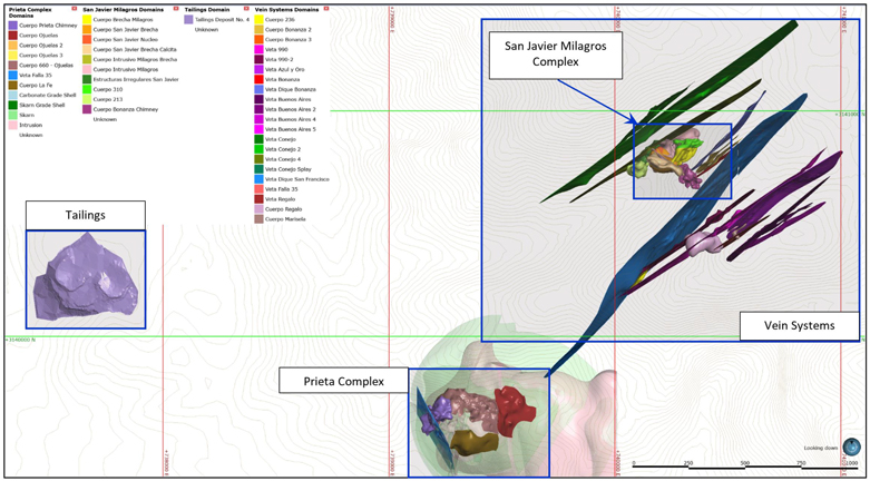
Note: Figure prepared by First Majestic, April 2025.

|
Note: When used for plan maps and figures, this compass symbol is a graphical representation of grid north, with the black triangle marking north. All map scales are in meters. |
| 40 | September 2025 |
| La Encantada Silver Mine Coahuila, Mexico NI 43-101 Technical Report on Mineral Resource and Mineral Reserve Estimates |
|
Mineralization at La Encantada consists of secondary oxide minerals that are the products of the strong supergene oxidation of primary sulphides, extending to >500 m depth. The most common oxide minerals are hematite, goethite, jarosite, argento-jarosite, cerussite, anglesite, zincite, pyrolusite, hemimorphite, smithsonite, willemite, malachite and brochanthite. Native silver occurs as the oxidation product of the silver sulphide mineral acanthite.
Native silver and oxide minerals also occur with sulphides in skarn and carbonate replacement zones where sulphides are partially converted to oxide minerals. The sulphide minerals acanthite, pyrite, magnetite, marmatite (iron-rich sphalerite), galena, chalcopyrite, and covellite occur in the Prieta and San Javier–Milagros complexes.
Filtered Tailings Storage Facility No.4 consists of cyanidation circuit filtered tailings from previously processed ore that has been stacked on the surface close to process Plant No. 2.
| 7.5.2. | Prieta Complex |
The Prieta complex silver, lead, and zinc polymetallic deposits consist primarily of massive lens-type and breccia pipe carbonate replacement deposits that formed adjacent to the limits of skarn alteration in Aurora Formation limestones. The skarn alteration also hosts silver, lead, zinc, and gold mineralization in a dome shaped halo that surrounds a granitic intrusion (Figure 7-7).
Figure 7-7: Plan View and Vertical Section of the Prieta Complex.
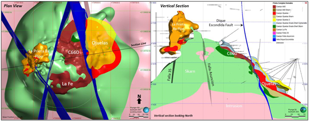
Note: Figure prepared by First Majestic, April 2025.
The massive lens type deposits include Ojuelas, Cuerpo 660, and La Fe. Together, these deposits form a nearly continuous carbonate replacement zone encircling the skarn alteration, between 1,425–1,675 m elevation, which has lateral dimensions of approximately 550 by 350 m. The Ojuelas deposit is positioned on the east side of the skarn alteration and is fault offset from the Cuerpo 660 deposit to deeper structural levels by the Dike Escondida normal fault. The La Fe deposit is positioned on the south side of the skarn alteration between 1,550 and 1,650 m elevation with lateral dimensions of approximately 300 by 150 m.
| 41 | September 2025 |
| La Encantada Silver Mine Coahuila, Mexico NI 43-101 Technical Report on Mineral Resource and Mineral Reserve Estimates |
|
Skarn-hosted mineralization and irregular carbonate replacement deposits are found surrounding the massive lens deposits. Locally the carbonate replacement mineralization appears to conform to the bedding of the limestone, but in other areas the mineralization crosscuts bedding. Structurally above the Ojuelas deposit the Aurora Formation is intensively fractured, with hematite staining along fractures.
The Prieta breccia pipe is a high-grade, polymetallic silver, lead, zinc deposit that formed on the west side of the complex adjacent to and structurally above the skarn alteration. The breccia body is an irregular chimney-shaped deposit that extends from 1,600–1,800 m in elevation with lateral extents of 100 by 100 m. The deposit is intensely oxidized and comminuted, obscuring primary textures. It is believed to have had a massive to semi-massive sulfide matrix originally.
Fault zones associated with the development of the Prieta breccia pipe and the massive lens carbonate replacement deposits also host polymetallic silver mineralization. The Falla 35 fault strikes northwest, crosscuts the Prieta breccia pipe and hosts vein-style mineralization to the southeast of the breccia, extending to the La Fe deposit. The Falla Asuncion fault strikes northeast and crosscuts both Cuerpo 660 to the north and La Fe to the south. Falla Asuncion can show silver and higher levels of gold as this structure is hosted primarily within skarn alteration, which contains disseminated gold.
| 7.5.3. | San Javier–Milagros Complex |
The San Javier–Milagros complex consists of a quartz monzonite stock bounded by two silver breccia pipe deposits and associated chimney-shaped, silver-bearing, carbonate replacement deposits. These are the San Javier and the Milagros breccias with the adjacent Nucleo and Cuerpo 310 replacement deposits. The Milagros intrusion also hosts lesser silver mineralization near its margins. The San Javier-Milagros complex extends from the 1,400 m elevation to surface at the 2,000 m elevation and has lateral extents of approximately 400 by 175 m.
The San Javier breccia is a poorly consolidated and predominantly clast-supported, chimney-shaped breccia consisting of sub-rounded limestone fragments (monomictic breccia) ranging in size from tens of centimetres to several metres. Some of the clasts are recrystallized or replaced by iron and manganese oxides, and the matrix is usually fine-grained oxidized and comminuted rock. In contrast, the Milagros breccia is a matrix-supported, chimney-shaped breccia consisting of limestone and intrusive clasts (polymictic breccia) varying in size from centimetres to tens of centimetres. The matrix of the Milagros breccia is made up of fine-grained and oxidized and comminuted rock. Most rock fragments in this breccia are rounded to sub-rounded. Figure 7-8 shows vertical and level plan views of the complex and Figure 7-9 shows examples of the Milagros breccia.
| 42 | September 2025 |
| La Encantada Silver Mine Coahuila, Mexico NI 43-101 Technical Report on Mineral Resource and Mineral Reserve Estimates |
|
Figure 7-8: Vertical Section and Plan View of the San Javier Milagros Complex
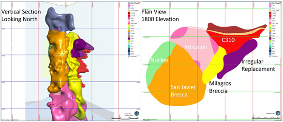
Note: Figure prepared by First Majestic, April 2025.
Figure 7-9: The Milagros Breccia Visible at the 1660 UG Level
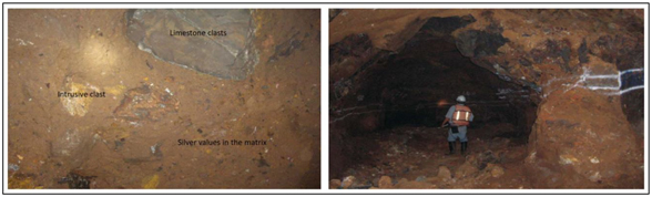
Note: Figure prepared by First Majestic, April 2025.
| 7.5.4. | Vein Systems |
The silver mineralization in the Vein systems consists of numerous, steeply-dipping, tabular-shaped deposits with open space-filling and carbonate replacement developed along northeast-trending faults and fractures. From north to south, are the Conejo, Bonanza, Dique San Francisco, 990, 990-2, Regalo, Azul y Oro and Buenos Aires vein systems (Figure 7-10).
| 43 | September 2025 |
| La Encantada Silver Mine Coahuila, Mexico NI 43-101 Technical Report on Mineral Resource and Mineral Reserve Estimates |
|
Figure 7-10: Plan View and Vertical Section of the Vein Systems.

Note: Figure prepared by First Majestic, April 2025.
Northwest-trending cross-faults intersect the northeast-trending veins, which occasionally favors the development of pipe-like chimneys or vein-hosted mineral shoots. Mineralogically, the veins consist of siderite, manganiferous calcite, calcite, hematite, goethite, pyrolusite, acanthite and native silver. Vein mineralization occurs commonly between 1,750– 1,950 metres elevation although greater vertical extents are encountered particularly at the intersections of the veins with the northwest-trending structures. The entire system has been recognized over an area that is approximately 2000 by 750 m. Veins typically pinch and swell and vein thickness varies between a few centimetres to several metres in the case of the Conejo and 990 vein systems. The Dique San Francisco is over 1,700 m in strike length and the vein structure contains an oxidized and argillic altered andesitic dike that has been mineralized along with the carbonate replacement adjacent to the dike.
| 44 | September 2025 |
| La Encantada Silver Mine Coahuila, Mexico NI 43-101 Technical Report on Mineral Resource and Mineral Reserve Estimates |
|
| 8. | DEPOSIT TYPES |
The principal mineral deposits at La Encantada are examples of high-temperature, carbonate-hosted silver-lead-zinc replacement deposits. According to Megaw (1988) and Plumlee (1995), polymetallic vein and replacement deposits are hosted in thick carbonate sedimentary sequences, they are commonly intimately associated with igneous intrusions, and they are controlled by local and regional structures. Vein and carbonate hosted silver-lead-zinc replacement deposits are characterized by irregular shaped pods, lenses, and roughly tabular mantos. Some carbonate replacement deposits (CRD) are associated with skarn alteration and mineralization also hosted by the sedimentary carbonate rocks.
Geochemical data indicate temperatures ranging from 200° to 500°C. The hotter solutions are typically from skarn zones adjacent to intrusions. The wide range of mineralization styles possessed by these deposits reflects different responses to intrusions, depth of emplacement, host-rock characteristics, structural control, and geochemical evolution.
The host carbonate rocks are often altered, recrystallized, or bleached, and in some deposits the carbonate minerals are replaced by calc-silicate skarn minerals such as epidote, garnet, and pyroxene in proximity to igneous intrusions. Mineralization may be hosted in the intrusions as well. Mineralization is present in mantos or massive lenses, pipes, and veins, and some massive ore contains > 50% sulfide minerals. A district may contain a series of orebodies controlled by both structures and stratigraphic features.
Discordant near vertical deposits with irregular elongate shapes proximal to main intrusions are referred to as chimneys and breccia pipes, such a San Javier, Milagros, and Prieta breccia deposits.
Tabular sub-vertical replacement deposits are referred to as veins, and they can contain richer mineral shoots or small chimneys at the intersection of northwest-trending faults and fractures. Steeply dipping, tabular deposits of the Vein Systems have a northeast orientation, and they are commonly distal to main intrusions. Narrow andesitic dikes are hosted along some northeast-trending vein/faults, and some host silver mineralization, e.g., the Dique San Francisco.
Massive lens replacements of the Prieta Complex are proximal to a granodiorite source intrusion, and they formed adjacent to skarn alteration. Contact metamorphic features (recrystallization to marble, development of hornfels and skarnoid) normally occurs peripheral to the skarn zone.
Figure 8-1 shows a schematic model of the polymetallic silver deposit types observed at La Encantada adapted from Megaw, 1988.
| 45 | September 2025 |
| La Encantada Silver Mine Coahuila, Mexico NI 43-101 Technical Report on Mineral Resource and Mineral Reserve Estimates |
|
Figure 8-1: Schematic of Carbonate Replacement Deposit Model.
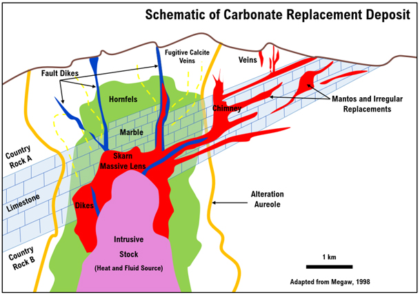
Note: Figure prepared by First Majestic, April 2025.
Exploration programs that use a CRD model are considered appropriate for the La Encantada area.
| 46 | September 2025 |
| La Encantada Silver Mine Coahuila, Mexico NI 43-101 Technical Report on Mineral Resource and Mineral Reserve Estimates |
|
| 9. | EXPLORATION |
Surface exploration work completed by First Majestic at La Encantada includes geological mapping, geochemical sampling, natural source audio-frequency magnetotellurics (NSAMT) geophysical survey, acquisition and processing of regional aeromagnetic data, an isotopic study, and core drilling. Surface geological mapping and sample geochemistry was completed at El Camello, Anomaly B, La Escalera and El Plomo, El Monje and La Esquina. Surface drilling has been carried out at Ojuelas in the Prieta complex, El Camello, El Plomo, Conejo Extension, Brecha Encanto, Veta Sucia, Veta Pajaritos, El Venado Bx and other areas with surface rock chip anomalies and/or other proxies to exploration prospectivity (Figure 9-1).
Figure 9-1: Location Map of Exploration Areas Showing Surface Rock Chip sample results.
Note: Figure prepared by First Majestic, April 2025.
| 47 | September 2025 |
| La Encantada Silver Mine Coahuila, Mexico NI 43-101 Technical Report on Mineral Resource and Mineral Reserve Estimates |
|
Underground exploration primarily consists of a combination of drilling and mine development, sampling, and mapping along structures due to the complexity of the mineralized bodies.
| 9.1. | Geophysical Surveys |
| 9.1.1. | Magnetic Surveys |
In 1994, Peñoles completed an aeromagnetic survey that identified five different magnetic highs. One of the magnetic anomalies lies over the Prieta complex. The other four anomalies were referred to by Peñoles as the A, B, C and D anomalies and occur within 4 km of the mine along a north–northwest trend. Mapping and geochemical surveys were conducted by Peñoles’ geologists on those anomalies.
In 2009, First Majestic acquired regional aeromagnetic data from Servicio Geológico Mexicano and retained the services of Instituto Potosino de Investigación Cientifica y Tecnología to perform data processing. The digital data were collected between 1975 and 1976 with flight lines-oriented northeast–southwest, line spacing of 1,000 m and altitude of 450 m with respect to the terrain. The study produced a reduction to pole (RTP) magnetic anomaly map showing sharp magnetic highs over intrusions in the region. In general, magnetic highs were identified over regional intrusions and magnetic lineaments could be distinguished along regional structures outside of the Project area.
In 2016, First Majestic contracted R.B. Ellis to conduct a local aeromagnetic survey over the La Encantada property. Analytic signal and RTP were successful in detecting intrusive bodies in the Prieta and San Javier Milagros complex areas. As a result, the methods, were recommended to be used in other areas to identify alignment of magnetic anomalies and linear features that could represent structures and intrusion sources. Figure 9-2 shows the RTP magnetic anomaly map and exploration areas.
| 48 | September 2025 |
| La Encantada Silver Mine Coahuila, Mexico NI 43-101 Technical Report on Mineral Resource and Mineral Reserve Estimates |
|
Figure 9-2: RTP Map Showing Magnetic Highs in Exploration Areas of Interest
Note: Figure prepared by First Majestic, April 2025.
| 9.1.2. | Natural Source Audio Magneto Telluric Survey |
In 2008, First Majestic hired Zonge Engineering and Research Organization (Zonge) to conduct a NSAMT survey) over the A, B, C and D magnetic highs, the La Escalera breccia and the Plomo anomaly. The study comprised 28 east-west oriented lines totaling 30 line-km with a station spacing of either 25 or 50 m.
The primary goal of the NSAMT survey was to assess the subsurface resistivity structure in the area east of the La Encantada mine. Except for one area (El Camello), survey data from six other sites, including Anomaly A, Anomaly B, Anomaly C, Anomaly D, Escalera, and El Plomo was of sufficient quality and resolution to provide reasonable geological interpretations from the observed resistivity models. Figure 9-3 shows the location of the NSAMT lines surveyed over the magnetic highs defined by Peñoles in 1994.
| 49 | September 2025 |
| La Encantada Silver Mine Coahuila, Mexico NI 43-101 Technical Report on Mineral Resource and Mineral Reserve Estimates |
|
Figure 9-3: Map Showing the Location of the NSAMT Survey Lines
Note: Figure prepared by First Majestic, April 2025.
Over Anomaly A, the study identified a low-angle structure cut intermittently by narrow vertical conductive features indicative of vertical faults or fractures in the shallow and mid depth range (Figure 9-4).
| 50 | September 2025 |
| La Encantada Silver Mine Coahuila, Mexico NI 43-101 Technical Report on Mineral Resource and Mineral Reserve Estimates |
|
Figure 9-4: NSAMT Section Across Anomaly A
Note: Figure prepared by First Majestic, April 2025.
Two core drill holes were completed to test the anomaly. The holes did not intercept silver mineralization but did intercept andesitic dikes and breccias.
The survey outlined a steep vertical gradient over Anomaly B, together with a change in resistivity character that may indicate a major fault (Figure 9-5).
| 51 | September 2025 |
| La Encantada Silver Mine Coahuila, Mexico NI 43-101 Technical Report on Mineral Resource and Mineral Reserve Estimates |
|
Figure 9-5: NSAMT Section Across Anomaly B
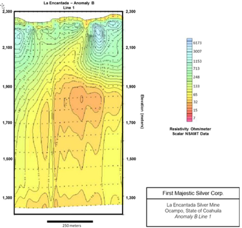
Note: Figure prepared by First Majestic, April 2025.
Two holes were drilled for a total of 1,263 m were drilled to test this area, but the results were negative.
Lines over Anomaly C near La Palma revealed a resistivity structure similar to that observed at Anomaly A
Three holes were drilled for a total of 1,476 m and intercepted a limestone clast-supported breccia with anomalous silver, lead, zinc, and mercury values.
Lines over the El Plomo anomaly indicate a subsurface resistivity structure similar to that observed at Anomaly B, and a feature of interest is located at about Station 475 on Line 2.
Here a narrow high resistivity dike-like feature is inferred from deep in the section extending upward to the near surface. A total of six holes were drilled totalling 2056 m at El Plomo and the holes indicate that the resistivity anomaly corresponds to a quartz-siderite vein hosted in a fault zone.
At La Escalera the data show a consistent subsurface resistivity anomaly, with a moderately conductive shallow layer (20–50 m thick) and a thick mid-depth range resistor (from about 100 m depth to 600–800
| 52 | September 2025 |
| La Encantada Silver Mine Coahuila, Mexico NI 43-101 Technical Report on Mineral Resource and Mineral Reserve Estimates |
|
m depth). Below the thick resistor is a thin, very conductive layer or contact (5–25 ohm-m) that grades into low to moderate resistivity to the base of the model sections.
A total of 1,240 m were drilled at La Escalera area in three holes but the results were negative.
| 9.2. | Stable Isotope Analysis |
In 2018 First Majestic completed an 18O and 13C stable isotope analysis over the intrusion-related San Javier–Milagros complex to test the ability of the method to identify buried intrusive rocks. Exploration geologists collected 33 surface samples from limestone outcrops along two different lines oriented northeast and northwest. The northwest orientation line revealed a decay in isotopic composition from samples close to the projection of Milagros intrusion (Figure 9-6).
| 53 | September 2025 |
| La Encantada Silver Mine Coahuila, Mexico NI 43-101 Technical Report on Mineral Resource and Mineral Reserve Estimates |
|
Figure 9-6: Location Map of Isotope Sampling and Results of d18O for the northwest line
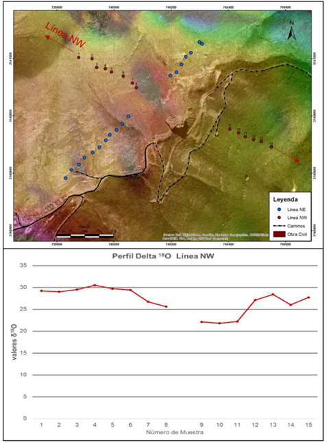
Note: Figure prepared by First Majestic, April 2025.
Based on the results from this investigation, additional studies are planned over areas where strong magnetic anomalies have been observed to test for the presence of possible intrusive rocks.
| 54 | September 2025 |
| La Encantada Silver Mine Coahuila, Mexico NI 43-101 Technical Report on Mineral Resource and Mineral Reserve Estimates |
|
| 10. | DRILLING |
From 2008–2011, drilling at La Encantada consisted of small diameter delineation drill holes used to support mine development. From 2011–2024, First Majestic conducted core drilling programs to explore the Project area and to support geological interpretations, modeling, and mineral resource estimates. No reverse circulation (RC) drilling has been carried out by First Majestic. Channel sampling from underground mine developments was completed to support mine production and Mineral Resource estimation.
Drilling can be separated into three distinct types per its objectives: Exploration drilling aiming to find new mineralization or extensions of known mineralization; Resource Upgrade, Infill drilling aiming to convert Inferred Resources into Indicated Resources; and Delineation drilling often times completed as “OPEX” and aiming to convert Indicated to Measured Resources derisking mining plans.
| 10.1. | Exploration and Infill Drilling |
Core drilling typically recovered HQ size core (63.5 mm core diameter) from surface and underground, and NQ size core (47.6 mm) was used where ground conditions required a reduction in core size to drill deeper. Between March 2011 and December 2024, several core drilling campaigns were completed. Total drilling during this period amounts to approximately 139,000 m across the mine areas and 193 m from 10 hollow stem auger drillholes in the Filtered Tailings Storage Facility No.4. Table 10-1 shows a summary of the drill holes completed and Figure 10-1 is a location map of the drill holes.
Table 10-1: Drill Holes Completed by First Majestic, La Encantada
| Drilling Year |
Company |
Drill Holes |
Meters Drilled |
|||||||
| 2011 |
First Majestic | 19 | 3,272 | |||||||
| 2012 |
First Majestic | 15 | 2,513 | |||||||
| 2013 |
First Majestic | 43 | 5,440 | |||||||
| 2014 |
First Majestic | 94 | 16,457 | |||||||
| 2015 |
First Majestic | 63 | 8,049 | |||||||
| 2016 |
First Majestic | 56 | 10,785 | |||||||
| 2017 |
First Majestic | 89 | 15,491 | |||||||
| 2018 |
First Majestic | 106 | 19,955 | |||||||
| 2019 |
First Majestic | 66 | 17,724 | |||||||
| 2020 |
First Majestic | 58 | 17,756 | |||||||
| 2021 |
First Majestic | 57 | 16,127 | |||||||
| 2022 |
First Majestic | 26 | 10,021 | |||||||
| 2023 |
First Majestic | 9 | 3,812 | |||||||
| 2024 |
First Majestic | 12 | 5,513 | |||||||
|
|
|
|
|
|||||||
| Grand Total |
713 | 152,914 | ||||||||
|
|
|
|
|
|||||||
| 55 | September 2025 |
| La Encantada Silver Mine Coahuila, Mexico NI 43-101 Technical Report on Mineral Resource and Mineral Reserve Estimates |
|
Figure 10-1: Drill Hole Location Map, La Encantada
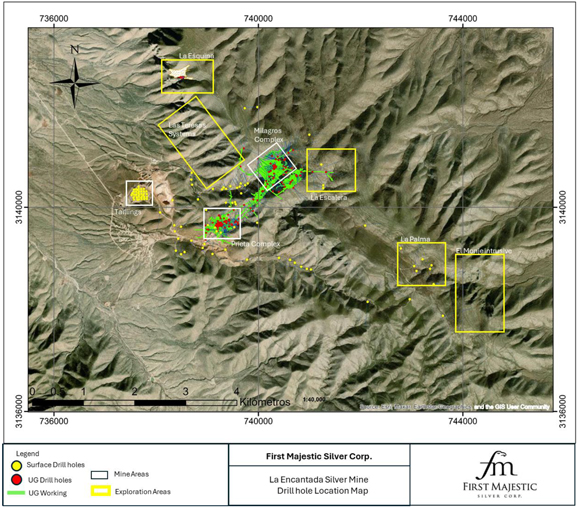
Note: Figure prepared by First Majestic, April 2025.
| 56 | September 2025 |
| La Encantada Silver Mine Coahuila, Mexico NI 43-101 Technical Report on Mineral Resource and Mineral Reserve Estimates |
|
| 10.2. | Core Handling and Storage |
The standard practice followed by First Majestic’s drillers and contractors under First Majestic supervision is:
| 1. | Extract the core every 3.05 m (length of one drilling rod or run), place the core onto a sample collector that matches the length of the run; |
| 2. | Break the core when necessary to ensure pieces match the length of the core box; |
| 3. | Mark the core using a coloured pencil at the place where it was broken; |
| 4. | Place the core into the core boxes, and then place a wooden block at the end of the run with the total depth of the hole and core length recovered in the run; |
| 5. | Mark hole ID and box number on the core boxes and lids, then once full, the core box is closed with a top lid and stacked for transportation. |
Core boxes from underground drilling are transported and delivered to the core shed by drillers at the end of every shift (drillers work 12-hour shifts). The core boxes are properly closed, and the box lids are secured with raffia fiber or rubber bands to prevent core from falling out of the box during transportation. The condition of the boxes, metre blocks and core are checked by one of the exploration geologists prior to core logging. Once the core boxes have been checked, the exploration technicians wash the core and inspect for out-of-sequence core pieces, mark every metre on the core, and labels depth intervals on core boxes and lids. Next the core is logged (recovery, rock quality designation (RQD), geotechnical and lithological logging), sampled, photographed, and afterward the core boxes are placed on racks within the secure environment of the core shed. Upon acquisition of La Encantada, First Majestic built a new core shed with an approximate capacity of 100,000 metres of core and rebuilt an old core shed originally built by Peñoles increasing the capacity to a total of approximately 130,000 m of core.
| 10.2.1. | Data Collection |
Data collected at La Encantada include collar surveys, downhole surveys, logging (lithology, alteration, mineralization, structure, veins, sampling, etc.), specific gravity (SG), and geotechnical information. The data collection practices employed by First Majestic are consistent with mining industry standard exploration and operational practices.
| 10.2.2. | Collar Survey |
Drill hole collars from campaigns prior to 2014 were surveyed by First Majestic surveyors using a Trimble S3 total station with accuracy of 2” in angular measurements, and 3 mm in distance. In late 2013, First Majestic hired Topografía y Construcción (Topcon) to survey the mine and hole-collars. Between late 2013 and 2014, Topcon re-surveyed some historic hole-collars, most of the collars from the 2013 drilling campaign, and surveyed all the collars from the 2014 drilling campaign. Topcon used a Sokkia 630 RK total station with accuracy of 6” in angular measurements, and 3 mm in distance. From 2015 to 2020, collars
| 57 | September 2025 |
| La Encantada Silver Mine Coahuila, Mexico NI 43-101 Technical Report on Mineral Resource and Mineral Reserve Estimates |
|
were surveyed by First Majestic surveyors using a Trimble S3, S5 and Sokkia total station. Since 2021 a Trimble S5, Trimble S7 and Leica TS06 total station have been used for collar surveys. In all cases, the collar information includes X, Y, Z coordinates, azimuth, and dip angle. Surveyors prepare certificates with collar data that are further archived and made available to users in the mine server.
| 10.2.3. | Down-hole Survey |
Down-hole trajectory data for holes drilled between 2013 and 2019 were measured using multi-shot DeviToolTM PeeWee and single-shot FLEXITTM surveying instruments. Since 2019, a DeviShot multi-shot instrument from Devico has been used for down-hole surveys. Each of these devices report measured depth in metres, azimuth in degrees, dip in degrees, temperature in Celsius, and magnetic field in nanoteslas. Measurements were collected every 25 m on average. The typical precision for these instruments is ± 0.25° for dip and ± 0.35° for azimuth. A correction to the east is added each year to every azimuth reading to compensate for changing magnetic declination. The observed average deviation in dip and azimuth for holes was less than 3° in both cases. Down-hole surveys were carried out by the drillers under the supervision of First Majestic geologists.
| 10.2.4. | Logging and Sampling |
First Majestic geologists complete core logging and sampling. Prior to core logging and sampling, the geologists make sure that all the core pieces are in place and in the correct order, check depth intervals on core boxes and lids and verify the wooden metre blocks (depth markers) are set at the appropriate depth in the core box. The geologists then describe geology (lithology, mineralogy, alteration, structures, etc.), mark sample intervals on the core as well as on core boxes and fill out pre-printed sample tags. For the selected sample intervals, a cutting line is marked along the core axis to ensure that the core is cut so that the half core sampled and the half core retained in the box are similar.
Sample tags for analytical quality control samples are added to the core boxes to preserve a continuous series of sample numbers. Quality control samples consisting of coarse blanks, pulp blanks, field duplicates, coarse duplicates, pulp duplicates and pulp standards with different silver grades were inserted in the sample stream prior to shipping to the primary laboratory. Pulp checks and coarse checks were also sent to a secondary laboratory (check assays).
After the geologists mark the sample locations and interval depths for SG on the core, technicians take core photographs.
Finally, the core is cut and sampled.
| 58 | September 2025 |
| La Encantada Silver Mine Coahuila, Mexico NI 43-101 Technical Report on Mineral Resource and Mineral Reserve Estimates |
|
| 10.2.5. | Specific Gravity and Bulk Density |
Since 2013, La Encantada geologists collect SG measurements from 15 cm average whole HQ or NQ core from mineralized zones and from wall rocks on either side of mineralized zones. SG is determined using a plastic-sealed water immersion method. In the plastic-sealed water immersion method, the samples are dried first in air, weighed, wrapped with plastic, and weighed again. The sample is then suspended in water and weighed again. Control samples such as duplicates, checks and standards are included. The SG is calculated using the following formula:
Where:
Wdry: Sample weight in dry
Wkp air: Wrapped sample weight
Wkp water: Sample weight – sample immerse in water
Kp density: plastic density
A total of 4,882 SG measurements were collected from 2011 to 2024 drill holes. Table 10-2 summarizes the SG results.
Table 10-2: Summary of SG Results
| Drilling Year |
Number of SG Samples |
Average SG |
||||||
| 2011 |
198 | 2.56 | ||||||
| 2012 |
179 | 2.51 | ||||||
| 2013 |
874 | 2.53 | ||||||
| 2014 |
1,376 | 2.57 | ||||||
| 2015 |
205 | 2.67 | ||||||
| 2016 |
272 | 2.59 | ||||||
| 2017 |
351 | 2.63 | ||||||
| 2018 |
408 | 2.47 | ||||||
| 2019 |
333 | 2.51 | ||||||
| 2020 |
258 | 2.58 | ||||||
| 2021 |
228 | 2.77 | ||||||
| 2022 |
103 | 2.63 | ||||||
| 2023 |
47 | 2.51 | ||||||
| 2024 |
50 | 2.58 | ||||||
|
|
|
|
|
|||||
| Grand Total |
4,882 | 2.57 | ||||||
|
|
|
|
|
|||||
Bulk density was also determined for partially consolidated fragments of tailings material. Consolidated fragments were coated with wax and the density was determined by the water immersion method at the
| 59 | September 2025 |
| La Encantada Silver Mine Coahuila, Mexico NI 43-101 Technical Report on Mineral Resource and Mineral Reserve Estimates |
|
Central Laboratory that is operated by First Majestic. The method consists of drying and weighing consolidated fragments of tailings material, then coating the samples with wax, and weighing again. The weight and volume of the coating wax is estimated to account for it in the final calculation of the bulk density. The bulk density is determined by the water immersion method by collecting and weighting the volume of water displaced by the sample, the volume of the coating wax is subtracted from the volume of displaced water to determine the sample volume, and the bulk density is determined using the following formula:
First Majestic performed a field experiment on the tailings deposit as a check to the previous method by obtaining one cubic metre of tailings material and weighting the sample. Then the sample weight (tonnes) was divided by the volume (1 m3). Sample humidity was determined to be 7.6% and was accounted for in the calculation of the bulk density. A bulk density of 1.98 t/m3 was determined with this experiment which is slightly lower than the average 2.05 g/cm3 determined with the water immersion method described above. The QP considers that 1.98 t/m3 is a minimum since the sample was collected from the top layer of material which is expected to be less consolidated than the rest of the material at depth, therefore the 2.05 g/cm3 was selected as the preferred value for bulk density.
| 10.2.6. | Core Recovery and Geotechnical Logging |
Core recoveries are estimated by First Majestic’s geologists and technicians at the core shed. The process consists of reassembling pieces of core, measuring the real core length recovered and then recording the recovered lengths per drill run. Since 2018 all recoveries are recorded directly into LogChief software. Previously recoveries were recorded on paper and then the information was transcribed into a spreadsheet template where the percent recoveries were estimated by dividing the measured length of core recovered over the length of the drill run.
Core recovery and RQD is estimated for every drill-hole. From 2015 to 2023, First Majestic implemented a more detailed core logging procedure that includes determination of rock hardness, fracture density, fracture orientation, and other conditions of the fractures such as spacing of fracture planes (Js) and roughness of planes (Jc), to calculate the rock mass rating (RMR)as defined by Bieniawski(1989). First Majestic staff determined the resistance of the rock to compression, or intact rock strength (IRS). Geotechnical core logging and determination of RMR and IRS values were performed for all the holes drilled in 2015, and for holes drilled in 2014 in the Ojuelas and Milagros areas. The logged data were initially recorded in hard-copy format and then transcribed into electronic spreadsheets for estimation of rock quality. Point load tests (PLT) were carried out on 19 core samples from the Ojuelas area at Cesia Ingeniería, in Hermosillo, Mexico.
| 60 | September 2025 |
| La Encantada Silver Mine Coahuila, Mexico NI 43-101 Technical Report on Mineral Resource and Mineral Reserve Estimates |
|
| 11. | SAMPLE PREPARATION, ANALYSES AND SECURITY |
| 11.1. | Core Sampling |
Pre-2013, mine geologists logged and sampled drill core in the core logging facility located at the La Encantada mine site. There is limited documentation regarding the core logging and sampling procedures for this period. Intervals recorded in 2012 lithology logs indicate that mineralization was visually identified, sampled, and assayed. Half of the core was sent for analysis at the La Encantada Laboratory, and the other half was retained for further investigations.
Sampling interval selections are currently based on First Majestic guidance to respect lithology and mineralization boundaries. On average, 25% of each hole is sampled. Sample intervals range from 0.2–2 m in mineralized areas. Shorter and longer lengths occur and are usually related to geological contacts in narrow mineralized structures (shorter lengths) or zones that are visibly barren or homogeneous in terms of lithology and alteration (longer lengths), or in fault zones with poor recoveries. All drill core intervals selected for sampling are cut in half along a designated cutting line using a diamond blade saw. One half of the core is retained in the core box and the other half is placed in sample bags for shipment to the laboratory. Sample tickets displaying the sample number are stapled into the core box beside the sampled interval, and a copy is placed in the sample bag. Sample bags are sealed to prevent contamination during handling and transportation. From 2013 to 2015 and from 2021 to 2022, core samples were shipped to the SGS laboratory in Durango, Durango, Mexico (SGS Durango). From 2016 to June 2023, core samples were shipped to First Majestic’s Central Laboratory (Central Laboratory) in San Jose La Parilla, Durango, Mexico. After Central Laboratory relocation in September 2023, core samples were submitted to the Central Laboratory at the current location in Santa Elena Silver/Gold Mine, Sonora, Mexico. Since August 2024, all core exploration samples are shipped to SGS Durango.
| 11.2. | Underground Production Channel Sampling |
Three-meter spaced production channel samples are used for geological models, grade control, and to support Mineral Resource estimation. The channel sample intervals range from 0.30–1.5 m and respect vein/wall contacts and textural or mineralogical features. Underground mine geologists use a hammer and hand chisel samples from a 10 cm to 20 cm wide swath along a sample line drawn on development faces. The chips are collected on a tarpaulin and fragments larger than 3 cm are broken into smaller pieces. A 1.0 kg sub-sample is bagged and labelled with sample number and location details. Sketches are collected of the sampled face, showing the location and length of each sample. Technicians mark the sample ID on the washed rock face for photography. The location coordinates from each sample line are surveyed using a total station survey method. Samples are dispatched to the La Encantada Laboratory.
From 2014 to 2015, 12-m spaced sawn channel samples were also collected to support Mineral Resource estimation. Samples were chipped from a 6 cm wide and 4 cm deep sawn channel. These samples were sent to SGS Durango.
| 61 | September 2025 |
| La Encantada Silver Mine Coahuila, Mexico NI 43-101 Technical Report on Mineral Resource and Mineral Reserve Estimates |
|
| 11.3. | Analytical Laboratories |
The laboratories used for sample preparation and analysis are summarized in Table 11-1.
Table 11-1: Analytical Laboratories
| Laboratory | Drilling Period | Certification | Independent | Comments | ||||
| SGS Durango | 2013–2015 | ISO/IEC 17025, ISO 9001 | Yes | Primary laboratory for drill core and sawn-channel samples. Secondary laboratory for check samples after 2018. | ||||
|
2018–2020 |
Sample preparation and analysis at the Durango, Mexico laboratory. |
|||||||
| 2021-2022 | ||||||||
| 2024 | ||||||||
| Bureau Veritas | 2014–2015 | ISO 9001, ISO/IEC 17025 | Yes | Secondary laboratory for check samples. | ||||
|
Sample preparation at the Durango, Mexico laboratory (formerly Inspectorate de Mexico). |
||||||||
|
Sample analysis at the Bureau Veritas Vancouver, Canada laboratory (formerly ACME laboratories). |
||||||||
| Central Laboratory | 2014–2023 | ISO 9001:2008 in June 2015, and ISO 9001:2015 in June 2018 | No | Primary laboratory for drill core and sawn-channel samples. | ||||
|
Located in Santa Elena Mine, Sonora, Mexico. |
||||||||
|
Sample preparation and analysis. |
||||||||
| La Encantada Laboratory | 1995–2024 | ISO 9001:2015 in December 2022 | No | Primary laboratory for underground drill core, ore control and production channel samples. Located at La Encantada mine. | ||||
|
Sample preparation and analysis. |
||||||||
| Managed by Central Laboratory |
| 11.4. | Sample Preparation and Analysis |
| 11.4.1. | SGS Durango |
Since 2013, drill core samples are dried at 105°C, crushed to 75% passing 2 mm, split to a 250 g sub-sample, and pulverized to 85% passing 75 µm.
Samples are analyzed for silver using a 2 g, three-acid digestion atomic absorption (AAS) method. Samples returning greater than 100 g/t Ag are reanalyzed for silver by a 30 g fire assay/gravimetric method. The overlimit values have changed over time, from 270 g/t in 2014 and 2015, 300 g/t in 2015, to 100 g/t
| 62 | September 2025 |
| La Encantada Silver Mine Coahuila, Mexico NI 43-101 Technical Report on Mineral Resource and Mineral Reserve Estimates |
|
starting in 2018. Gold is analyzed by a 30 g fire assay atomic absorption (AA) method. There have been no overlimit results for gold.
All samples are analyzed for 34 elements using an 0.25 g, aqua regia digestion inductively coupled plasma optical emission spectroscopy (ICP OES) or atomic emission spectroscopy (ICP AES) method. Over limit results of manganese, lead and zinc are analyzed by sodium peroxide fusion and by a titration method.
Since 2018, SGS Durango has only been used as an umpire laboratory for channel samples primary analyzed at La Encantada Laboratory and for core samples previously analyzed at Central Laboratory. Check samples submitted to SGS Durango are analyzed for silver using 2 g, four-acid digestion with AA finish. Samples returning greater than 100 g/t Ag are reanalyzed for silver by 30 g fire assay gravimetric method.
| 11.4.2. | Central Laboratory |
From 2015 to 2023, drill core samples were dried at 100 °C ± 5°C, crushed to 85% passing 2 mm, split to a 250 g sub-sample, and pulverized to 85% passing 75 µm. Since 2019, the crushing and pulverizing thresholds have been changed to 85% passing 2 mm and 85% passing 75 µm in an effort to improve precision.
All samples were analyzed for 34 elements by a two-acid digestion ICP method. All drill core and channel samples were also analyzed for silver by a 2 g, three-acid digestion, AA method. Samples returning greater than 200 g/t Ag were reanalyzed for silver by a 30 g, fire assay/gravimetric method. Gold was analyzed by 20 g fire assay with an AAS finish method. There have been no overlimit results for gold.
| 11.4.3. | Bureau Veritas |
At Bureau Veritas, samples were crushed in a jaw crusher to 70% passing 2 mm and split to a 250 g sub-sample and pulverized to 85% passing 75 µm.
All samples were analyzed for 33 elements using 0.5 g, and aqua regia digestion with an ICP finish. All samples were analyzed for silver by a 0.5 g aqua-regia digestion/ICP finish and four-acid digestion/AAS finish. Samples returning >1,000 g/t Ag were reanalyzed for silver by a 30 g fire assay/gravimetric finish. Gold was analyzed by 30 g fire assay with an AA finish. There have been no overlimit results for gold.
| 11.4.4. | La Encantada Laboratory |
From 2008 to 2014, samples were dried, weighed, crushed to 3/8”, split to 300 g and pulverized. Silver was analyzed using 10 g fire assay gravimetric finish. Iron, zinc, lead, copper, cadmium, and manganese were analyzed using a 1 g three-acid digest with an AAS finish. Since 2015, samples are dried at 105oC, crushed to 80% passing 2 mm, split to 200 g and pulverized to 80% passing 75 µm. Samples are analyzed
| 63 | September 2025 |
| La Encantada Silver Mine Coahuila, Mexico NI 43-101 Technical Report on Mineral Resource and Mineral Reserve Estimates |
|
for silver by a 20 g fire assay/gravimetric finish method. Copper, iron, lead, manganese, and zinc are analyzed by a 0.1 g 2-acid digestion/AA finish.
Analytical methods used by the SGS Durango, Central, Bureau Veritas and the La Encantada mine laboratories are shown in Table 11-2.
Table 11-2: Laboratory Analytical Methods
| SGS Durango | ||||||
| Code | Element | Limits | Description | |||
| GE AAS33E50 | Ag g/t | 0.3–100 | 2 g, 3-acid digestion, AAS finish. | |||
| GO FAG37V | Ag g/t | >10 | 30 g, fire assay, gravimetric finish. | |||
| GE AAS42E | Ag g/t | 0.3–100 | 2 g, 4-acid digest, AAS finish. | |||
| GE ICP21B20 | Ag ppm | 2–100 | 0.25 g, aqua-regia digestion ICP-OES finish. | |||
| GE FAA30V5 | Au g/t | 0.005–10 | 30 g, fire assay, AAS finish. | |||
| GE ICP21B20 | 34 elements | various | 0.25 g, aqua-regia digestion ICP-OES finish. | |||
| GO ICP90Q100 | Mn, Pb, Zn | various | 0.20 g, sodium peroxide fusion/ICP-AES finish. | |||
| GO CONV12V | Pb, Zn | various | Titration | |||
| Central Laboratory | ||||||
| Code | Element | Limits | Description | |||
| AAG-13 | Ag g/t | 0.5–200 | 2 g, 3-acid digest, AAS finish. | |||
| ASAG-12 | Ag g/t | >5 | 20 g, fire assay gravimetric finish. | |||
| AUAA-13 | Au g/t | 0.01-10 | 20 g, fire assay AAS finish. | |||
| ICP34BM | 34 elements | various | 0.25 g, 2-acid digestion ICP | |||
| Bureau Veritas Mineral Laboratories (check laboratory) | ||||||
| Code | Element | Limits | Description | |||
| AQ300 | Ag g/t | 0.3–100 | 0.5 g aqua-regia digestion ICP-ES finish | |||
| MA402 | Ag g/t | 1–1,000 | 4 -acid AAS finish | |||
| FA530 | Ag g/t | >50 | 30 g, fire assay gravimetric finish | |||
| FA430 | Au g/t | 0.005-10 | Fire assay AAS finish. | |||
| AQ300 | Multi-element | various | Aqua-regia digestion ICP-ES analysis | |||
| La Encantada Laboratory | ||||||
| Code | Element | Limits | Description | |||
| ASAG-12 | Ag g/t | >5 | 30 g by fire assay gravimetric finish | |||
| AWA-100 | Pb, Zn, Cu, Mn | Multi-element | 2-acid digestion atomic absorption finish | |||
| 64 | September 2025 |
| La Encantada Silver Mine Coahuila, Mexico NI 43-101 Technical Report on Mineral Resource and Mineral Reserve Estimates |
|
| 11.5. | Quality Control and Quality Assurance |
| 11.5.1. | Materials and Insertion Rates |
There is limited information regarding quality assurance and quality control (QA/QC) practices prior to 2013.
Since 2013 samples submitted to the primary laboratories include standard reference materials (SRMs) and certified reference materials (CRMs), coarse and pulp blanks, and field, coarse and pulp duplicates. Check samples sent to a secondary laboratory were introduced in 2014 and became a customary practice by 2018. Approximately one standard, one blank and one duplicate were inserted in a batch of 50 samples submitted to SGS Durango, Central and La Encantada Laboratories. Between 1% to 7% percent checks were submitted to Bureau Veritas and SGS Durango laboratories.
First Majestic prepared five SRMs using material from the La Parrilla Silver Mine, Durango and three SRMs using material from La Encantada. These SRMs underwent round robin analysis to identify expected values and were used from 2013 to 2019. As the SRMs were depleted, they were replaced with commercially available CRMs purchased from CDN Laboratories. Since 2020, only CRMs have been used in the channel and core sample-stream.
Before 2013, unused fusion crucibles were used periodically for pulp and coarse blank materials. From 2013 to 2018, the coarse blank material was obtained from limestone collected from creek banks near La Encantada. Pulp blanks were obtained from industrial silica sand used at the La Encantada process plant. Since 2018, First Majestic uses industrial coarse and pulp blanks and are purchased from Sonora Naturals, a provider of laboratory material in Hermosillo.
| 11.5.2. | Transcription and Sample Handling Errors |
In preliminary stages of the QA/QC program, there were a large amount of transcription errors identified at each laboratory. Procedures were changed and subsequently no significant transcriptions errors or sample handling issues have been identified.
| 11.5.3. | Accuracy Assessment |
First Majestic assesses accuracy in terms of bias of the mean values returned for the SRMs or CRMs relative to the expected value. A bias between ± 5 % is considered acceptable. The SRM and CRM results are plotted on time sequence performance charts. Sample swaps and transcription errors are removed before assessing bias. Results from standards within mineralized zones with greater than the mean ± three times the standard deviation are re-assayed.
| 65 | September 2025 |
| La Encantada Silver Mine Coahuila, Mexico NI 43-101 Technical Report on Mineral Resource and Mineral Reserve Estimates |
|
| 11.5.3.1. | Central Laboratory |
Between 2014 to 2018, four different SRMs were submitted with samples sent to the Central Laboratory. The results indicate no significant bias for silver results.
Between 2019 and 2023, four different SRMs and nine different CRMs were submitted with samples sent to the Central Laboratory. The results indicate no significant bias for silver results. An example of the time sequence plot for the 2021–2022 standard assessment for the Central Laboratory is shown in Figure 11-1.
Figure 11-1: Central Laboratory High Grade CRM Standard Control Chart
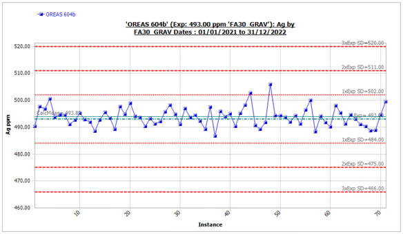
Total =71, # Outliers=0, Expected Val=493, Mean=493.83, SD=3.53, CV=0.0168, Bias of Mean=0.17%, 95%confint=0.82
Note: Figure prepared by First Majestic, April 2025.
| 11.5.3.2. | SGS |
From 2013 to 2018, thirteen different SRMs were submitted with core samples sent to SGS Durango. The SRM results indicate no significant bias for silver except for results from one standard indicating a marginal but acceptable positive bias.
From 2021 to 2022 and in 2024, five different CRMs were submitted with core samples sent to SGS Durango. The CRMs results show no significant bias for silver except for one standard showing a marginal but acceptable bias.
| 11.5.3.3. | La Encantada Laboratory |
There are insufficient SRMs results to assess accuracy at the La Encantada Laboratory before 2016. The SRMs and CRMs results from 2016 to 2024 indicate no significant bias for silver.
| 66 | September 2025 |
| La Encantada Silver Mine Coahuila, Mexico NI 43-101 Technical Report on Mineral Resource and Mineral Reserve Estimates |
|
| 11.5.4. | Contamination Assessment |
First Majestic assesses contamination in terms of the values of blank control samples. Coarse blanks returning results less than twice the detection limit value 80% of the time, and pulp blanks returning results less than twice the detection limit value 90% of the time are considered acceptable. Blank results are plotted in a time-sequence blank performance chart. Outliers related to sample swaps or transcription errors are removed before calculating the frequency. Batches with excessive blank failure rates are re-assayed.
SGS Laboratory
From 2013 to 2018, from 2021 to 2022 and in 2024, more than 90% of the coarse and pulp blanks silver values were less than two times the detection limit. The results indicate no significant contamination for silver.
Central Laboratory
From 2014 to 2023, more than 90% of the coarse and pulp blanks silver values were less than two times the detection limit. The results indicate no significant contamination for silver.
La Encantada Laboratory
There is no information supporting contamination assessment before 2014. From 2014–2024, 100% of the coarse and pulp blanks silver values were less than two times the detection limit. The results indicate no contamination for silver. An example of blank sequence performance charts for La Encantada Laboratory silver results is shown in Figure 11-2.
| 67 | September 2025 |
| La Encantada Silver Mine Coahuila, Mexico NI 43-101 Technical Report on Mineral Resource and Mineral Reserve Estimates |
|
Figure 11-2: Time Sequence Pulp Blank Performance Chart, La Encantada Laboratory Silver Results 2019-2024
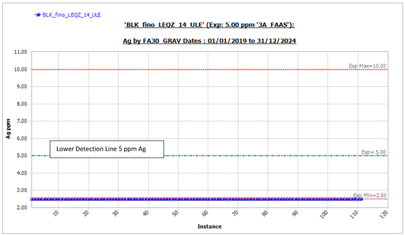
Note: Figure prepared by Fist Majestic, April 2025.
| 11.5.5. | Precision Assessment |
First Majestic assesses precision in terms of frequency of absolute relative difference (ARD) of paired duplicate values. The target precision is between 85% and 90% frequency of ARD <30%, 20% and 10% for field, coarse and pulp duplicates. Sample swaps and transcription errors are removed before assessing precision. Paired duplicate results, excluding outliers, are plotted on ARD versus frequency charts to visually inspect the sample frequency meeting the precision target. Duplicate precision is continually monitored and if precision targets are not met, the laboratories are consulted.
SGS
From 2013 to 2018, field duplicate silver ARD results were close to but did not meet the precision target. Precision began to improve in 2016. From 2021 to 2022 and in 2024, field duplicate silver results met precision target. From 2013 to 2018, 2021 to 2023 and in 2024, coarse and pulp duplicate silver results met the precision targets.
Central Laboratory
From 2014 to 2018, field duplicate silver results were close but did not meet the precision target. Precision began to improve in 2019. From 2019 to 2023, field duplicates met the precision target. Before 2019, coarse and pulp silver results were close to the target precision. After 2019, coarse and pulp silver results met precision targets.
| 68 | September 2025 |
| La Encantada Silver Mine Coahuila, Mexico NI 43-101 Technical Report on Mineral Resource and Mineral Reserve Estimates |
|
La Encantada Laboratory
There is no information supporting precision assessment before 2011.
From 2011 to 2013, field duplicate silver results did not meet the precision target. Since 2018, field, coarse and pulp duplicate silver results have met the precision targets.
| 11.5.6. | Between-Laboratory Bias Assessment |
First Majestic assesses between-laboratory bias in terms of the slope of a reduced major axis (RMA) line. Paired primary and secondary laboratory results are plotted on an x-y scatterplot and an RMA line is estimated after excluding outliers such as paired results with below detection values and paired results with significant ARD. An RMA line slope between 0.95–1.05 is considered an acceptable between laboratory bias.
From 2014 to 2024, the RMA analysis of samples submitted to all secondary laboratories indicate no significant bias between the primary laboratory and the secondary laboratory.
Control samples submitted with the checks samples from all sample periods showed no material precision, accuracy, or contamination issues.
A summary of between laboratory biases is shown in Table 11-3. An example of laboratory bias chart between La Encantada Laboratory and SGS Durango from check results from 2019–2024 is shown in Figure 11-3.
Table 11-3: Summary Between Laboratory Bias. Silver Results
| Primary Laboratory | SGS | FMCL | FMCL | ULE | ||||||||||||
| Check Laboratory | BV | SGS | SGS | SGS | ||||||||||||
| Assessment Period |
2014-2015 | 2017-2018 | 2019-2024 | 2019-2024 | ||||||||||||
| Check Type |
Coarse |
Pulp |
Coarse |
Pulp |
Pulp |
Pulp |
||||||||||
| Ag | Ag | Ag | Ag | Ag | Ag | |||||||||||
| Primary Method |
3-acid AAS |
3-acid AAS | 3-acid AAS | 3-acid AAs | FAGRAV | 3 Acid AAS | FAGRAV | FAGRAV | ||||||||
| Check Method |
4-acid AAS |
4-acid AAS | 3-acid AAS | 3-acid AAs | FAGRAV | 3Acid AAS | FAGRAV | FAGRAV | ||||||||
| Number of samples |
182 | 182 | 105 | 176 | 64 | 139 | 112 | 157 | ||||||||
| Insertion Rate % |
2% | 2% | 1% | 2% | 1% | 2% | 2% | 3% | ||||||||
| Excluded Outliers % |
1% | 3% | 4% | 4% | 5% | 7% | 5% | 1% | ||||||||
| Slope |
0.99 | 0.99 | 1.05 | 1 | 1.03 | 1.03 | 1.03 | 1.04 | ||||||||
Note: SGS = SGS Durango, BV = Bureau Veritas, FMCL = Central Laboratory, ULE = La Encantada laboratory, FAGRAV = fire assay/gravimetric.
| 69 | September 2025 |
| La Encantada Silver Mine Coahuila, Mexico NI 43-101 Technical Report on Mineral Resource and Mineral Reserve Estimates |
|
Figure 11-3: RMA Plot Ranges Above 100 ppm Ag. La Encantada Laboratory 2019–2024 Check Results
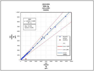
Note: Figure prepared by First Majestic, April 2025.
| 11.6. | Databases |
La Encantada drill hole and production channel data are stored in a secured SQL database, based on the Maxwell GeoServices database scheme. First Majestic received the assay data from the laboratories via emails in comma-separated value (CSV) data files. These files are compiled and imported using Maxwell’s DataShed™, a database management software. The import process includes a series of built-in checks for errors. After data are imported, visual checks are done to ensure that data were imported properly.
| 11.7. | Sample Security |
| 11.7.1. | Production Channel Samples |
Throughout historical and current mine operations, production channel samples were sent from the sampling areas to the La Encantada Laboratory by First Majestic personnel, where they are kept in a secured and fenced area. After analysis, the samples are disposed of in the processing plant.
All sawn channel samples sent off site were securely sealed and chain-of-custody documents issued for all shipments. After analysis, samples were returned to La Encantada mine and stored at the core storage warehouse.
| 70 | September 2025 |
| La Encantada Silver Mine Coahuila, Mexico NI 43-101 Technical Report on Mineral Resource and Mineral Reserve Estimates |
|
| 11.7.2. | Core Samples |
Throughout historical and current drilling periods, drill core was transported from drilling areas to the core storage warehouse by drilling contractors, where they are kept in a secured and fenced area.
Since 2013, core samples were transported from the La Encantada core storage warehouse to the SGS Durango by First Majestic personnel using company trucks. From 2016 to 2024, core samples were transported from the La Encantada core storage warehouse to the Central Laboratory by First Majestic personnel using company trucks.
All samples are securely sealed, and chain-of-custody documents issued for all shipments. After analysis, pulp and coarse reject samples are returned to La Encantada where they are stored in the secure core storage warehouse.
| 11.8. | Author’s Opinion |
Sample preparation, analysis and quality control measures used at the primary and secondary laboratories meet current industry standards and are providing reliable silver and lead results. Sample security procedures used for transporting channel samples and drill core to the core warehouse and from the core warehouse to the laboratories are in accordance with industry standards. The database management procedure used to receive, and record results are providing reliable integrity to the samples results.
The absence of a QA/QC program supporting channel and drill core sample analysis at La Encantada laboratory before 2016 is mitigated by the following:
| • | Pre-2016 drill core samples assayed at the La Encantada Laboratory represent less than 2% of the total resource database samples; |
| • | In 2013, a resampling program of 2011 and 2012 drill holes supports that no significant difference between SGS and La Encantada Laboratory results; |
| • | Starting in 2013, under Central Laboratory management, the La Encantada Laboratory received new equipment for sample preparation, revised sample preparation and analysis procedures, and conducted employee training. |
Since 2016, the La Encantada Laboratory uses LIMS, a laboratory information management system for receiving and reporting assay results and all sample batches include laboratory quality control samples. In December 2022, the laboratory obtained the ISO 9001:2015.
Production channel samples used to support grade estimation were assessed for laboratory accuracy and laboratory precision. The field sampling procedure for production channel samples has some risk of introducing sampling bias but any potential bias has not yet been fully assessed.
| 71 | September 2025 |
| La Encantada Silver Mine Coahuila, Mexico NI 43-101 Technical Report on Mineral Resource and Mineral Reserve Estimates |
|
| 12. | DATA VERIFICATION |
The data verification included data entry error checks, visual inspections of data collected between 2013 and2024 and a review of QA/QC assay results was completed. Several site visits were completed as part of the data verification process.
| 12.1. | Data Entry Error Checks |
The data entry error checks consisted of comparing data recorded in the database with original collar survey reports, lithology logs and assay reports, and investigation of gaps, overlaps and duplicate intervals in the sample and lithology tables.
No significant data entry errors were observed in a 5% random selection of the drill collar locations of the verification dataset. The error check consisted of a comparison of the verification dataset collar locations with survey reports issued by First Majestic’s planning department.
No significant data entry errors were observed in a 5% random selection of the lithology records of the verification dataset. The error check consisted of a comparison of the verification dataset lithology records with records exported from the logging software.
No significant data entry errors were observed in a 5% random selection of the silver assay results of the verification dataset. The error check consisted of a comparison of the verification dataset assays with original electronic copies and final laboratory certificates issued by SGS Durango, Central and the La Encantada Laboratories.
The inspection for gaps, overlap, and duplicates for all lithology and sample records identified no issues.
SG measurements were verified for transcription errors and for errors in the SG measurement procedure. The error check consisted of a comparison of the verification dataset with original SG logs. SG formulas used in the calculations were also verified.
No significant data entry errors were observed in the SG sample intervals or during the measurement procedure.
| 12.2. | Visual Data Inspection |
Visual inspection consisted of verifying the position of collars relative to the underground workings, down-hole deviation, lithology, and assay intervals relative to the three-dimensional (3D) geological models. The visual inspection also included comparison of lithology and assay intervals with core photos.
A 5% random selection of drill hole collar and channel locations in the verification dataset indicated no significant position errors.
| 72 | September 2025 |
| La Encantada Silver Mine Coahuila, Mexico NI 43-101 Technical Report on Mineral Resource and Mineral Reserve Estimates |
|
A 5% random selection of drill hole traces revealed no unusual kinks or bends.
A 5% random selection of the drill hole lithology intervals indicated no significant position errors relative to the three-dimension geological models.
A 5% random selection of lithology intervals of the verification datasets were visually inspected using core photos. Observed lithology, mineralogy, sample lengths and sample numbers were compared to the logged data. No significant differences were observed.
| 12.3. | Review QA/QC Assay Results |
Verification of assay accuracy and contamination is provided in Section 11 of this Technical Report.
| 12.4. | Author’s Opinion |
The data verification identified no significant issues with data entry, grade accuracy, precision, or contamination. The visual inspection in 3D of drill hole and channel samples identified no issues with drill hole and sample locations. The database is considered sufficiently free of error and adequate to support Mineral Resource estimation.
Data verification for transcription errors was not completed on pre-2013 drill hole data due to limited or missing original supporting data. Pre-2013 drill hole data represents less than 6% of the database and less than 2% of the pre-2013 drill holes were used to support the current Mineral Resource estimate.
| 73 | September 2025 |
| La Encantada Silver Mine Coahuila, Mexico NI 43-101 Technical Report on Mineral Resource and Mineral Reserve Estimates |
|
| 13. | MINERAL PROCESSING AND METALLURGICAL TESTING |
| 13.1. | Overview |
The La Encantada mine is an operating mine and the metallurgical testwork data supporting the initial plant design has been proven and reinforced by plant operating results through the years of operation combined with more recent metallurgical studies.
| 13.2. | Metallurgical Testing |
Metallurgical testing and mineralogical investigations are conducted regularly at the on-site Metallurgical Laboratory. The plant continuously performs testwork aimed at optimizing silver recovery and reducing operating costs, even when results fall within expected performance parameters. These efforts support operational improvements such as fine-tuning reagent consumption, maintaining target grind sizes, adjusting the backwash circuit, and evaluating alternative reagents. Monthly composite samples are analyzed to assess the metallurgical response of the ore processed, while geometallurgical studies are carried out to understand variability and similarities in future feed material scheduled for mining.
| 13.2.1. | Mineralogy |
The most abundant mineralogical species of the La Encantada deposits, both metallic and non-metallic include:
| • | Metallic minerals (in order of abundance): goethite (FeO(OH)), hematite (Fe2O3), cerussite (PbCO3), anglesite (PbSO4), galena (PbS), other lead oxides, smithsonite (ZnCO3), Mn oxides, pyrolusite (MnO2), Cu carbonates, acanthite/argentite (Ag2S), embolite (AgCl), electrum. |
| • | Non-metallic minerals (in order of abundance): calcite (CaCO3), quartz (SiO2), garnet ((Ca,Fe,Mg,Mn)3(Al,Fe,Mn,Cr,Ti,V)2(SiO4)3), K-feldspar (KAlSi3O8 – NaAlSi3O8 – CaAl2Si2O8), swelling clay, dolomite (CaMg(CO3)2, kaolinite (Al2Si2O5(OH)4), chlorite ((Mg,Fe)3(Si,Al)4O10(OH)2-(Mg,Fe) 3(OH)6). |
The typical mineralogy of the La Encantada deposits is provided in Figure 13-1.
| 74 | September 2025 |
| La Encantada Silver Mine Coahuila, Mexico NI 43-101 Technical Report on Mineral Resource and Mineral Reserve Estimates |
|
Figure 13-1: Typical Distribution of Minerals, La Encantada
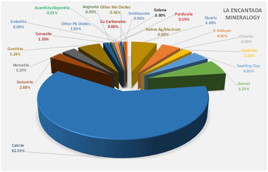
Note: Figure prepared by First Majestic, April 2025.
| 13.2.2. | Monthly Composite Samples |
Daily and per-shift samples are collected from the mill feed based on the tonnage processed, with representative portions retained to create a monthly composite. This composite is prepared by the plant metallurgist in coordination with the La Encantada metallurgy team. One key objective of the program is to build a database that correlates laboratory-scale metallurgical test results with the actual performance of the cyanidation plant.
| 13.2.3. | Sample Preparation |
Samples submitted to the on-site Metallurgical Laboratory are first dried, then crushed to either -10 or -6 mesh, depending on the specific testwork requirements.
| 13.3. | Comminution Evaluations |
Since January 2013, First Majestic has routinely conducted Bond Ball Work Index (BWi) tests on monthly composite samples. Table 13-1 presents the results of these Bond ball mill grindability tests, conducted between January 2016 and January 2025, using 150- and 200-mesh closing screens on run-of-mine (ROM) mineralized material.
| 75 | September 2025 |
| La Encantada Silver Mine Coahuila, Mexico NI 43-101 Technical Report on Mineral Resource and Mineral Reserve Estimates |
|
Table 13-1: Grindability Test Results for Different Composite Samples of La Encantada Mine
| Sample ID | BWi (kWh/t) |
Sample ID | BWi (kWh/t) |
|||||||
| 2016 | January Composite | 10.6 | 2018 | April Composite | 10.5 | |||||
| February Composite | 10.6 | May Composite | 10.7 | |||||||
| March Composite | 10.3 | June Composite | 10.4 | |||||||
| April Composite | 9.0 | July Composite | 8.0 | |||||||
| May Composite | 10.3 | August Composite | 11.4 | |||||||
| June Composite | 7.9 | September Composite | 10.0 | |||||||
| July Composite | 10.7 | 2019 | January Composite | 9.9 | ||||||
| August Composite | 10.5 | March Composite | 10.2 | |||||||
| September Composite | 11.5 | April Composite | 8.9 | |||||||
| October Composite | 10.2 | 2020 | February Composite | 9.6 | ||||||
| November Composite | 11.0 | December Composite | 9.1 | |||||||
| December Composite | 10.0 | 2021 | January Composite | 10.1 | ||||||
| 2017 | January Composite | 11.1 | 2022 | August Composite | 11.3 | |||||
| February Composite | 11.5 | September Composite | 10.6 | |||||||
| March Composite | 11.9 | October Composite | 11.8 | |||||||
| April Composite | 12.0 | 2024 | May Composite | 9.6 | ||||||
| May Composite | 11.1 | November Composite | 7.9 | |||||||
| July Composite | 12.0 | 2025 | January Composite | 10.4 | ||||||
| August Composite | 10.3 | |||||||||
| October Composite | 10.9 | |||||||||
| Average | 10.4 | |||||||||
| Standard Deviation | 1.1 | |||||||||
| Minimum | 7.9 | |||||||||
| 10th Percentile | 9.0 | |||||||||
| Median | 10.4 | |||||||||
| 90th Percentile | 11.6 | |||||||||
| Maximum | 12.0 | |||||||||
The BWi results demonstrate a relatively low level of variability with 80% of the values ranging from 9.4–12.1 kWh/t and averaging 10.8 kWh/t.
| 13.4. | Cyanidation, Reagent and Grind Size Evaluations |
In addition to evaluating the repeatability of silver metallurgical recovery for each monthly composite, targeted testwork is also conducted to investigate specific operational challenges or requirements identified in the lead-up to sample collection. These tests may include:
| • | Standard cyanidation under plant-like conditions (e.g., grind size, reagent addition, and leach residence time); |
| 76 | September 2025 |
| La Encantada Silver Mine Coahuila, Mexico NI 43-101 Technical Report on Mineral Resource and Mineral Reserve Estimates |
|
| • | Cyanidation trials with varying grinding sizes. |
Results from these tests are shared with plant operations teams to inform continuous improvement initiatives. As part of ongoing performance tracking, Figure 13-2 compares actual monthly plant silver recovery with corresponding laboratory test results on monthly composites. Over the period evaluated, plant performance has shown strong alignment with lab-scale outcomes.
Figure 13-2: Comparison of Ag Extraction Between Mill and Laboratory Performances
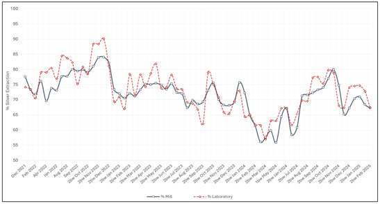
Note: Figure prepared by First Majestic, April 2025.
| 13.5. | Cyanidation with Lead Nitrate |
Lead nitrate addition was initially evaluated at laboratory scale under controlled cyanidation conditions, demonstrating a consistent improvement in silver dissolution kinetics. Based on these positive results, the practice was implemented at the plant level. Since its application, the plant has observed a 1–2% increase in silver recovery, aligning with laboratory expectations and supporting its continued use as a beneficial process enhancement.
| 77 | September 2025 |
| La Encantada Silver Mine Coahuila, Mexico NI 43-101 Technical Report on Mineral Resource and Mineral Reserve Estimates |
|
Figure 13-3: Lead Nitrate Test Results
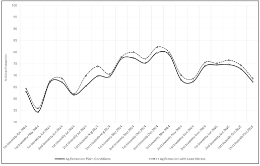
Note: Figure prepared by First Majestic, April 2025.
| 13.6. | Cyanidation Higher pH Range |
Leaching tests conducted at higher pH levels in the on-site Metallurgical Laboratory demonstrated improved silver recovery during the agitation stage. Following these findings, operational changes were made to target a higher pH range in the leach circuit.
| 78 | September 2025 |
| La Encantada Silver Mine Coahuila, Mexico NI 43-101 Technical Report on Mineral Resource and Mineral Reserve Estimates |
|
Figure 13-4: La Encantada Silver Recovery for Higher pH Range
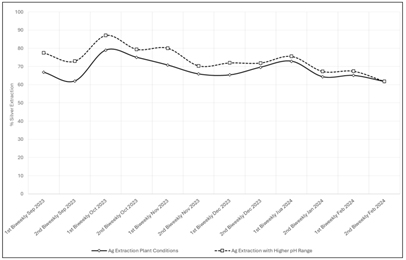
Note: Figure prepared by First Majestic, April 2025.
As a result, average silver recovery increased from 68.2% to 73.6%, consistent with the behavior observed in laboratory testing. This improvement is illustrated in the accompanying box plot.
Figure 13-5: La Encantada Box Plot of Silver Recovery for Higher pH Range
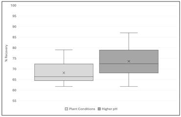
Note: Figure prepared by First Majestic, April 2025.
| 13.7. | Roasting and Cyanidation |
Manganese oxides significantly hinder silver recovery due to their chemical and physical properties. Minerals such as romanechite, pyrolusite, and hetaerolite are highly reactive and tend to consume cyanide and oxygen, reducing the effectiveness of leaching. These oxides often occur with iron oxides like hematite and goethite, forming dense networks that create impermeable barriers and encapsulate silver-
| 79 | September 2025 |
| La Encantada Silver Mine Coahuila, Mexico NI 43-101 Technical Report on Mineral Resource and Mineral Reserve Estimates |
|
bearing minerals. This results in poor mineral liberation and limited solubility, even at ultra-fine grind sizes.
Reflected light microscopy studies have identified freibergite as the dominant silver mineral, followed by argentojarosite, acanthite, electrum, and cerargyrite. Approximately 52% of these silver minerals are associated with lead minerals such as cerussite and galena, which also show poor response to cyanidation due to limited solubility.
To address these issues, thermal treatment through roasting and the use of reducing agents like sodium sulfite and sodium chloride have been proposed. These methods aim to alter the chemical structure of manganese and lead phases, converting them into more soluble forms and enhancing silver recovery.
Figure 13-6 illustrates that recoveries below 25%, even after intensive treatments such as ultra-fine grinding to 8 microns, are consistent with the mineralogical limitations identified in these studies. However, roasting significantly improves these values ranging from 55% to 70%.
Figure 13-6: Tailings “High Manganese” Test Results
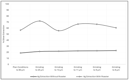
Note: Figure prepared by First Majestic, April 2025.
| 13.8. | Ojuelas Geometallurgical Testing |
Metallurgical testwork conducted on mineralized material from Ojuelas indicates silver recoveries ranging from 60% to 70%. The testing used the same operating conditions as the La Encantada processing plant, including the standard flowsheet and typical reagent additions. Higher recoveries are generally associated with material from the upper portion of the deposit, while lower recoveries are expected in the lower zones. The test flowsheet is shown in Figure 13-7, and detailed recovery results are presented in Figure 13-8.
| 80 | September 2025 |
| La Encantada Silver Mine Coahuila, Mexico NI 43-101 Technical Report on Mineral Resource and Mineral Reserve Estimates |
|
Figure 13-7: Flowsheet Sequence – Ojuelas Metallurgical Testing Investigation
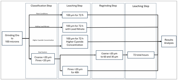
Note: Figure prepared by First Majestic, April 2025.
Figure 13-8: Silver Extraction from Ojuelas Mine
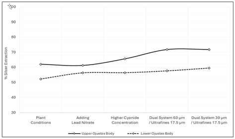
Note: Figure prepared by First Majestic, April 2025.
| 13.9. | Geometallurgical Investigations |
Metallurgical variability has been incorporated into the life-of-mine (LOM) plan by assigning recovery projections to each geological domain. For areas currently in operation, such as the San Javier–Milagros breccia complex and the Veta Dique San Francisco, projected recoveries are based on actual plant performance. For zones scheduled for future extraction, including Ojuelas, Conejo, and other veins, recovery estimates are informed by laboratory test work results.
| 81 | September 2025 |
| La Encantada Silver Mine Coahuila, Mexico NI 43-101 Technical Report on Mineral Resource and Mineral Reserve Estimates |
|
Figure 13-9: La Encantada Box Plot of Silver Head Grades 2024
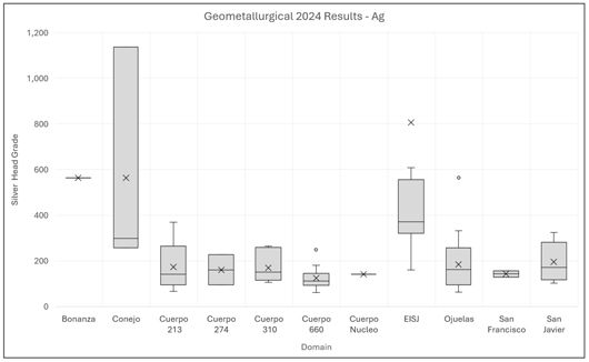
Note: Figure prepared by First Majestic, April 2025.
Figure 13-10: La Encantada Box Plot of Silver Recoveries Grades 2024
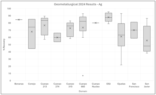
Note: Figure prepared by First Majestic, April 2025.
| 82 | September 2025 |
| La Encantada Silver Mine Coahuila, Mexico NI 43-101 Technical Report on Mineral Resource and Mineral Reserve Estimates |
|
| 13.10. | Recovery Estimates |
Table 13-2 summarizes typical metal recoveries for La Encantada plant-feed, showing an average silver recovery of 73.2% from 2021 to 2024.
Table 13-2: Metallurgical Recoveries by Year
| Year |
Production |
Recovery |
||||||
| 2021 |
1,004 | 77.4 | % | |||||
| 2022 |
1,025 | 76.4 | % | |||||
| 2023 |
966 | 72.5 | % | |||||
| 2024 |
897 | 66.6 | % | |||||
| Yearly Average |
973 | 73.2 | % | |||||
The silver recovery estimates for the LOM plan are based on the assumed metallurgical recoveries for the different domains as listed in Table 13-3.
Table 13-3: Metallurgical Recoveries by Domain
| Domain |
Ag Recovery |
|||
| Veta Dique San Francisco |
70.0 | % | ||
| Conejo |
50.0 | % | ||
| Veins Systems (990, BA, VAYO, Bonanza) |
55.0 | % | ||
| Breccias, Chimneys, Mantos - Milagros |
70.8 | % | ||
| Breccias, Chimneys, Mantos - C660-Ojuelas |
59.0 | % | ||
| Tailings No. 4 - Reprocessing |
66.7 | % | ||
| Tailings No. 4 - Roaster |
65.0 | % | ||
The average yearly silver recovery projected in the LOM plan range from 60% to 70%.
| 13.11. | Deleterious Elements |
The doré silver content ranges from 60–85% due to the presence of copper, lead, and zinc. This relatively low concentration of silver is addressed in the sales agreement. A representative treatment charge was included in the cut-off grade calculation and in the LOM plan economic evaluations.
| 83 | September 2025 |
| La Encantada Silver Mine Coahuila, Mexico NI 43-101 Technical Report on Mineral Resource and Mineral Reserve Estimates |
|
Figure 13-11: Monthly Dore Purity 2021 -2024
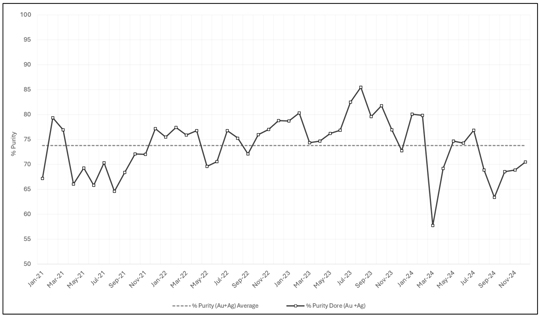
Note: Figure prepared by First Majestic, April 2025.
Although the lead content in the doré has tripled in 2024 compared to the 2021–2023 period, this increase is attributed to the implementation of a higher pulp pH, a measure adopted to improve recovery. As previously mentioned, this is addressed in the sales agreement.
Figure 13-12: La Encantada Box Plot of Lead Dore Concentration 2021- 2024
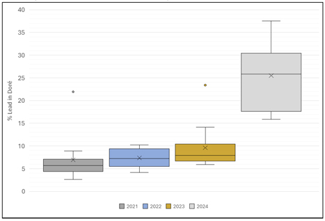
Note: Figure prepared by First Majestic, April 2025.
| 84 | September 2025 |
| La Encantada Silver Mine Coahuila, Mexico NI 43-101 Technical Report on Mineral Resource and Mineral Reserve Estimates |
|
| 14. | MINERAL RESOURCE ESTIMATES |
| 14.1. | Introduction |
This section describes the resource estimation methodology and summarizes key assumptions considered by First Majestic for the Mineral Resource estimates for the La Encantada mine. The Mineral Resource estimates are prepared in accordance with CIM Estimation of Mineral Resource and Mineral Reserve Best Practice Guidelines (November 2019) and follow the CIM Definition Standards for Mineral Resources and Mineral Reserves (May 2014), that are incorporated by reference in NI 43-101.
The geological modelling, data analysis, and block model resource estimates for La Encantada were completed by Karla Michelle Calderon Guevara, CPG, a First Majestic employee.
| 14.2. | Mineral Resource Estimation Process |
The block model Mineral Resource estimates are based on the database of exploration drill holes and production channel samples, underground level geological mapping, geological interpretations and models, as well as surface topography and underground mining development wireframes available as of the December 31, 2024, the cut-off date for scientific and technical data supporting the estimates.
Geostatistical analysis, analysis of semi-variograms, and validation of the model blocks were completed with Leapfrog EDGE. Stope analysis to determine reasonable prospects for eventual economic extraction was completed with Deswik Stope Optimizer.
The process followed for the estimation of Mineral Resources included:
| • | Database compilation and verification. |
| • | Review of data quality for primary and interpreted data and QAQC. |
| • | Setup of the resource project with sample database, surface topography, and mining depletion wireframes and inspection in 3D space. |
| • | Three-dimensional geological interpretation, modelling, and definition of the Mineral Resource estimation domains. |
| • | Exploratory data and boundary analysis of the resource estimation domains. |
| • | Sample data preparation (compositing and capping) for variography and block model estimation. |
| • | Trend and spatial analysis: variography. |
| • | Bulk density review. |
| • | Block model resource estimation. |
| • | Validation and classification of the block model resource estimates. |
| • | Depletion of the Mineral Resource estimates due to mining. |
| • | Development of appropriate economic parameters and assessment of reasonable prospects for eventual economic extraction. |
| • | Summary compilation of the Mineral Resource estimates. |
| 85 | September 2025 |
| La Encantada Silver Mine Coahuila, Mexico NI 43-101 Technical Report on Mineral Resource and Mineral Reserve Estimates |
|
| 14.2.1. | Sample Database |
The combined drill hole and channel sample database for La Encantada was reviewed and verified by the resource geologists and supports that the QA/QC program was reasonable. The sample data used in Mineral Resource estimation has a cut-off date of December 31, 2024, and consists of exploration core drill holes and production channel samples.
| 86 | September 2025 |
| La Encantada Silver Mine Coahuila, Mexico NI 43-101 Technical Report on Mineral Resource and Mineral Reserve Estimates |
|
Table 14-1 and
| 87 | September 2025 |
| La Encantada Silver Mine Coahuila, Mexico NI 43-101 Technical Report on Mineral Resource and Mineral Reserve Estimates |
|
Table 14-2 summarize the drill hole and production channel sample data in the resource domains used in the Mineral Resource estimation. Figure 14-1 shows the relative location of the sample data with respect to the mine zones in section and plan view.
| 88 | September 2025 |
| La Encantada Silver Mine Coahuila, Mexico NI 43-101 Technical Report on Mineral Resource and Mineral Reserve Estimates |
|
Table 14-1: Drill Hole Sample Data by Domain, La Encantada
| Resource Domains |
Resource Domain Code | No. of Drill Holes | No. of Samples | Interval Length (m) | ||||||||||
| Cuerpo 310 |
C310 | 13 | 225 | 251 | ||||||||||
| Cuerpo 236 |
C236 | 9 | 120 | 81 | ||||||||||
| Cuerpo 660 Limestone |
C660 | 16 | 185 | 119 | ||||||||||
| Cuerpo 660 Skarn |
C660_Skn | 16 | 148 | 117 | ||||||||||
| Cuerpo Asuncion Falla |
CASNF | 41 | 608 | 388 | ||||||||||
| Cuerpo Bonanza 2 |
CBN2 | 16 | 250 | 119 | ||||||||||
| Cuerpo Bonanza 3 |
CBN3 | 16 | 309 | 142 | ||||||||||
| Cuerpo Falla 35 |
CF35 | 8 | 45 | 33 | ||||||||||
| Cuerpo Intrusivo Milagros |
CMLI | 54 | 2,449 | 2,440 | ||||||||||
| Cuerpo Intrusivo Milagros Brecha |
CBXI | 22 | 1,099 | 1,268 | ||||||||||
| Cuerpo La Fe |
CLFE | 32 | 327 | 197 | ||||||||||
| Cuerpo Marisela |
CMAR | 2 | 42 | 35 | ||||||||||
| Cuerpo Milagros Brecha |
CMLX | 27 | 923 | 1,057 | ||||||||||
| Cuerpo Ojuelas 2 |
COJ2 | 55 | 512 | 432 | ||||||||||
| Cuerpo Ojuelas Limestone |
COJU | 57 | 1,148 | 964 | ||||||||||
| Cuerpo Ojuelas Skarn |
COJU_Skn | 16 | 153 | 128 | ||||||||||
| Cuerpo Regalo |
CREG | 11 | 255 | 277 | ||||||||||
| Gradeshell Limestone |
KaGS | 48 | 537 | 460 | ||||||||||
| Gradeshell Skarn |
SknGS | 45 | 978 | 792 | ||||||||||
| Tailings |
TLN4 | 41 | 523 | 1,068 | ||||||||||
| Veta 990 |
V990 | 67 | 249 | 164 | ||||||||||
| Veta 990-2 |
V990-2 | 66 | 353 | 260 | ||||||||||
| Veta Azul y Oro |
VAYO | 19 | 60 | 125 | ||||||||||
| Veta Bonanza |
VBNZ | 27 | 220 | 92 | ||||||||||
| Veta Buenos Aires |
VBNA | 35 | 170 | 118 | ||||||||||
| Veta Buenos Aires 2 |
VBN2 | 25 | 84 | 64 | ||||||||||
| Veta Buenos Aires 4 |
VBN4 | 4 | 14 | 11 | ||||||||||
| Veta Buenos Aires 5 |
VBN5 | 15 | 25 | 14 | ||||||||||
| Veta Conejo |
VCNJ | 50 | 348 | 220 | ||||||||||
| Veta Conejo 2 |
VCN2 | 92 | 880 | 477 | ||||||||||
| Veta Conejo 4 (Ojitos) |
VOJS | 94 | 229 | 117 | ||||||||||
| Veta Conejo Splay |
VCNS | 16 | 25 | 11 | ||||||||||
| Veta Dique Bonanza |
VDBN | 28 | 110 | 76 | ||||||||||
| Veta Dique Escondida |
VDESC | 57 | 373 | 278 | ||||||||||
| Veta Dique San Francisco |
VDSF | 96 | 368 | 206 | ||||||||||
| Veta El Regalo |
VREG | 30 | 54 | 26 | ||||||||||
|
|
|
|
|
|
|
|||||||||
| Grand Total |
1,266 | 14,398 | 12,626 | |||||||||||
|
|
|
|
|
|
|
|||||||||
| 89 | September 2025 |
| La Encantada Silver Mine Coahuila, Mexico NI 43-101 Technical Report on Mineral Resource and Mineral Reserve Estimates |
|
Table 14-2: Production Channel Sample Data by Domain, La Encantada
| Resource Domains |
Resource Domain Code | No. of Channels | No. of Samples | Interval Length (m) | ||||||||||
| Cuerpo 310 |
C310 | 1,739 | 5,306 | 7,604 | ||||||||||
| Cuerpo 236 |
C236 | 105 | 388 | 296 | ||||||||||
| Cuerpo 660 Skarn |
C660_Skn | 7 | 24 | 22 | ||||||||||
| Cuerpo Intrusivo Milagros |
CMLI | 253 | 616 | 898 | ||||||||||
| Cuerpo Intrusivo Milagros Brecha |
CBXI | 20 | 68 | 70 | ||||||||||
| Cuerpo Marisela |
CMAR | 51 | 179 | 145 | ||||||||||
| Cuerpo Milagros Brecha |
CMLX | 625 | 1,710 | 2,730 | ||||||||||
| Cuerpo Ojuelas Limestone |
COJU | 21 | 74 | 80 | ||||||||||
| Cuerpo Regalo |
CREG | 232 | 1,399 | 1,306 | ||||||||||
| Gradeshell Limestone |
KaGS | 16 | 42 | 42 | ||||||||||
| Gradeshell Skarn |
SknGS | 6 | 36 | 36 | ||||||||||
| Veta 990 |
V990 | 397 | 1,241 | 1,091 | ||||||||||
| Veta 990—2 |
V990-2 | 216 | 621 | 541 | ||||||||||
| Veta Azul y Oro |
VAYO | 249 | 572 | 424 | ||||||||||
| Veta Bonanza |
VBNZ | 66 | 149 | 121 | ||||||||||
| Veta Buenos Aires |
VBNA | 236 | 822 | 730 | ||||||||||
| Veta Buenos Aires 2 |
VBN2 | 236 | 486 | 342 | ||||||||||
| Veta Buenos Aires 4 |
VBN4 | 34 | 131 | 115 | ||||||||||
| Veta Buenos Aires 5 |
VBN5 | 60 | 165 | 129 | ||||||||||
| Veta Conejo |
VCNJ | 247 | 762 | 661 | ||||||||||
| Veta Conejo 2 |
VCN2 | 72 | 241 | 230 | ||||||||||
| Veta Conejo 4 (Ojitos) |
VOJS | 16 | 20 | 12 | ||||||||||
| Veta Conejo Splay |
VCNS | 59 | 91 | 66 | ||||||||||
| Veta Dique Bonanza |
VDBN | 51 | 128 | 88 | ||||||||||
| Veta Dique Escondida |
VDESC | 17 | 33 | 28 | ||||||||||
| Veta Dique San Francisco |
VDSF | 541 | 1,216 | 961 | ||||||||||
| Veta El Regalo |
VREG | 208 | 421 | 308 | ||||||||||
|
|
|
|
|
|
|
|||||||||
| Grand Total |
5,780 | 16,941 | 19,077 | |||||||||||
|
|
|
|
|
|
|
|||||||||
| 90 | September 2025 |
| La Encantada Silver Mine Coahuila, Mexico NI 43-101 Technical Report on Mineral Resource and Mineral Reserve Estimates |
|
Figure 14-1: Drill Hole and Channel Locations, Resource Domains, and Mine Areas: Plan View
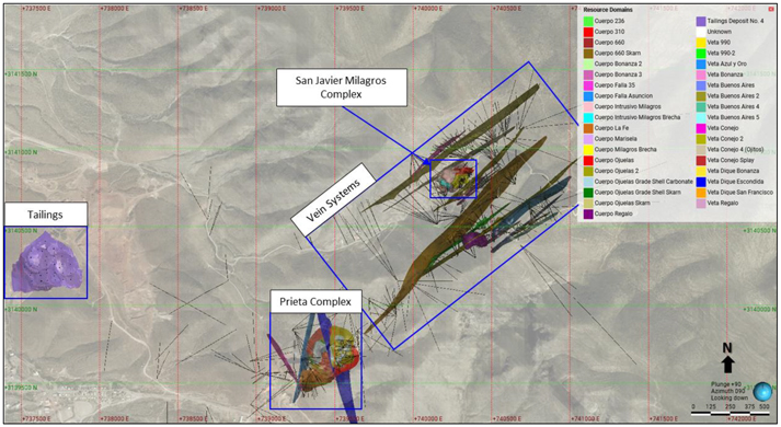
Note: Figure prepared by First Majestic, May 2025.
| 91 | September 2025 |
| La Encantada Silver Mine Coahuila, Mexico NI 43-101 Technical Report on Mineral Resource and Mineral Reserve Estimates |
|
| 14.2.2. | Geological Interpretation and Modeling |
The Mineral Resource estimates for the deposits at La Encantada are constrained by 3D geological interpretation and geological domain models. The domains are constructed from core logs, drill hole and production channel sample assay intervals, and underground geological mapping. Silver estimates are restricted to the domain models of tabular veins, mantos, massive lenses, breccia pipes, and irregular replacement zones. The domain model boundaries strictly adhere to the vein and breccia contacts with the surrounding country rock to produce reasonable representations of the mineralization locations and volumes. Table 14-3 lists the 40 domains modeled within the four mine areas at La Encantada.
Table 14-3: Mine Area, Ore Nature, Host-Rock, Resource Domains and Codes, La Encantada
| ID | Area | Ore Nature | Host | Resource Domains | Code | |||||
| 1 | Prieta Complex | Irregular Replacement | Carbonate-Hosted | Cuerpo Ojuelas Grade Shell Carbonate | KaGS | |||||
| 2 | Prieta Complex | Irregular Replacement | Skarn-Hosted | Cuerpo Ojuelas Grade Shell Skarn | SknGS | |||||
| 3 | Prieta Complex | Massive Lens - Replacement | Carbonate-Hosted | Cuerpo 660 | C660 | |||||
| 4 | Prieta Complex | Massive Lens - Replacement | Skarn-Hosted | Cuerpo 660 Skarn | C660_Skn | |||||
| 5 | Prieta Complex | Massive Lens - Replacement | Carbonate-Hosted | Cuerpo Ojuelas | COJU | |||||
| 6 | Prieta Complex | Massive Lens - Replacement | Skarn-Hosted | Cuerpo Ojuelas Skarn | COJU_SKn | |||||
| 7 | Prieta Complex | Massive Lens - Replacement | Carbonate-Hosted | Cuerpo Ojuelas 2 | COJ2 | |||||
| 8 | Prieta Complex | Massive Lens - Replacement | Carbonate-Hosted | Cuerpo La Fe | CLFE | |||||
| 9 | Prieta Complex | Vein | Carbonate-Hosted | Cuerpo Falla 35 | CF35 | |||||
| 10 | Prieta Complex | Vein | Skarn-Hosted | Cuerpo Falla Asuncion | CASNF | |||||
| 11 | Prieta Complex | Vein | Carbonate-Hosted | Veta Dique Escondida | VDESC | |||||
| 12 | Prieta Complex | Vein | Carbonate-Hosted | Veta Dique Escondida Splay | VDESD | |||||
| 13 | San Javier Milagros Complex | Breccia Pipe | Carbonate-Hosted | Cuerpo Milagros Brecha | CMLX | |||||
| 14 | San Javier Milagros Complex | Pipe | Carbonate-Hosted | Cuerpo 310 | C310 | |||||
| 15 | San Javier Milagros Complex | Pipe | Igneous-Hosted | Cuerpo Intrusivo Milagros | CMLI | |||||
| 16 | San Javier Milagros Complex | Pipe | Igneous-Hosted | Cuerpo Intrusivo Milagros Brecha | CBXI | |||||
| 17 | Vein System | Irregular Replacement | Carbonate-Hosted | Cuerpo 236 | C236 | |||||
| 18 | Vein System | Irregular Replacement | Carbonate-Hosted | Cuerpo Bonanza 2 | CBN2 | |||||
| 19 | Vein System | Irregular Replacement | Carbonate-Hosted | Cuerpo Bonanza 3 | CBN3 | |||||
| 20 | Vein System | Irregular Replacement | Carbonate-Hosted | Cuerpo Marisela | CMAR | |||||
| 21 | Vein System | Irregular Replacement | Carbonate-Hosted | Cuerpo Regalo | CREG | |||||
| 22 | Vein System | Vein | Carbonate-Hosted | Veta 990 | V990 | |||||
| 23 | Vein System | Vein | Carbonate-Hosted | Veta 990-2 | V990-2 | |||||
| 24 | Vein System | Vein | Carbonate-Hosted | Veta Azul y Oro | VAYO | |||||
| 92 | September 2025 |
| La Encantada Silver Mine Coahuila, Mexico NI 43-101 Technical Report on Mineral Resource and Mineral Reserve Estimates |
|
| ID | Area | Ore Nature | Host | Resource Domains | Code | |||||
| 25 | Vein System | Vein | Carbonate-Hosted | Veta Bonanza | VBNZ | |||||
|
26 |
Vein System |
Vein |
Carbonate-Hosted |
Veta Buenos Aires |
VBNA |
|||||
|
27 |
Vein System |
Vein |
Carbonate-Hosted |
Veta Buenos Aires 2 |
VBN2 |
|||||
|
28 |
Vein System |
Vein |
Carbonate-Hosted |
Veta Buenos Aires 4 |
VBN4 |
|||||
|
29 |
Vein System |
Vein |
Carbonate-Hosted |
Veta Buenos Aires 5 |
VBN5 |
|||||
|
30 |
Vein System |
Vein |
Carbonate-Hosted |
Veta Conejo |
VCNJ |
|||||
|
31 |
Vein System |
Vein |
Carbonate-Hosted |
Veta Conejo 2 |
VCN2 |
|||||
|
32 |
Vein System |
Vein |
Carbonate-Hosted |
Veta Conejo 4 (Ojitos) |
VOJS |
|||||
|
33 |
Vein System |
Vein |
Carbonate-Hosted |
Veta Conejo Splay |
VCNS |
|||||
|
34 |
Vein System |
Vein |
Carbonate-Hosted |
Veta Dique Bonanza |
VDBN |
|||||
|
35 |
Vein System |
Vein |
Carbonate-Hosted |
Veta Dique San Francisco |
VDSF |
|||||
|
36 |
Vein System |
Vein |
Carbonate-Hosted |
Veta Regalo |
VREG |
|||||
|
37 |
Tailings |
Tailings |
Tailings |
Tailings Deposit No. 4 |
TLN4 |
Figure 14-1 showed the mineral deposit and resource domains that were grouped by deposit type and mine area location. Figure 14-2 to Figure 14-5 display the modelled resource domains for the four mine areas: the Prieta complex, the San Javier–Milagros complex, the Vein systems, and the Tailings Deposit No. 4.
Figure 14-2: Vertical Section and Plan View Location of the San Javier–Milagros Complex Domains
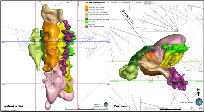
Vertical section is full projection. Note: Figure prepared by First Majestic, April 2025.
| 93 | September 2025 |
| La Encantada Silver Mine Coahuila, Mexico NI 43-101 Technical Report on Mineral Resource and Mineral Reserve Estimates |
|
Figure 14-3: Plan View Location and Vertical Section of the Vein Systems Domains
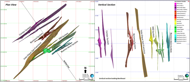
Note: Figure prepared by First Majestic, April 2025.
Figure 14-4: Plan View Location and Vertical Section of the Prieta Complex Domains

Note: Figure prepared by First Majestic, April 2025.
| 94 | September 2025 |
| La Encantada Silver Mine Coahuila, Mexico NI 43-101 Technical Report on Mineral Resource and Mineral Reserve Estimates |
|
Figure 14-5: Vertical Section and Plan View Location of the Tailings Deposit No. 4 Domain
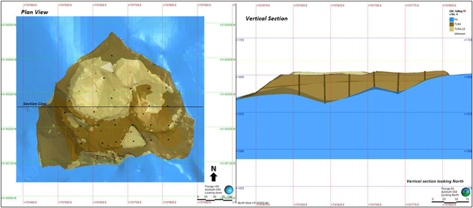
Note: Figure prepared by First Majestic, April 2025.
| 14.2.3. | Exploratory Sample Data Analysis |
Exploratory data analysis was completed to assess the statistical and spatial character of the sample data. Data were examined in 3D to understand the spatial distribution of mineralized intervals. The sample assay data statistics were analyzed within each domain to ensure the sample population is a good representation of the domain.
| 14.2.4. | Boundary Analysis |
Boundary analysis was completed for each of the domains to review the change in metal grade across the domain contacts using boundary plots. There is a sharp grade change across the contact and hard boundary conditions are observed for most deposits. Some sub-domains within the Ojuelas C660 and San Javier Milagros complex display semi-soft conditions and distance-restricted soft boundaries were used for those domains. Figure 14-6 and
Note: Prepared by First Majestic, May 2025.
Figure 14-7 show examples of hard and soft boundary conditions for the Veta Conejo and Cuerpo Ojuelas, respectively.
| 95 | September 2025 |
| La Encantada Silver Mine Coahuila, Mexico NI 43-101 Technical Report on Mineral Resource and Mineral Reserve Estimates |
|
Figure 14-6: Example of Hard Boundary Silver Conditions for the Veta Conejo
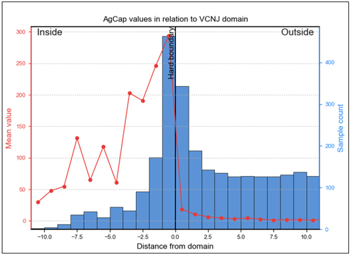
Note: Prepared by First Majestic, May 2025.
Figure 14-7: Example of Soft Boundary Silver Conditions Between Cuerpo Ojuelas Sub-Domains: Carbonate Replacement against Skarn Alteration
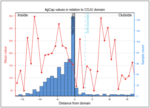
Note: Figure prepared by First Majestic, May 2025.
Hard boundaries were used during the construction of sample composite samples and during Mineral Resource estimation. Composite samples were restricted to their respective resource domain except for those modified soft boundary conditions applied for certain domains in the San Javier–Milagros complex.
| 96 | September 2025 |
| La Encantada Silver Mine Coahuila, Mexico NI 43-101 Technical Report on Mineral Resource and Mineral Reserve Estimates |
|
| 14.2.5. | Compositing |
To select an appropriate composite sample length, the assay sample intervals were reviewed for each domain. The composite length selected varies by domain, with short residual composite samples left at the end of the vein intersection added to the previous interval. Composites generally were 1 m or 2 m lengths. Composite sample lengths are detailed in Table 14-4 and Figure 14-8 shows an example of sample interval lengths before and after compositing for the Cuerpo Ojuelas domain.
Table 14-4: Composite Sample Preparation, La Encantada
| Area | Resource Domain Code | Composite Length (m) | Minimum Residual Length (m) |
Residual End Length Treatment |
||||
| Prieta Complex | KaGS | 2.0 | 0.5 | Add to Previous Interval | ||||
| Prieta Complex | SknGS | 2.0 | 0.5 | |||||
| Prieta Complex | C660 | 2.0 | 0.5 | |||||
| Prieta Complex | C660_Skn | 2.0 | 0.5 | |||||
| Prieta Complex | COJU | 2.0 | 0.5 | |||||
| Prieta Complex | COJU_SKn | 2.0 | 0.5 | |||||
| Prieta Complex | COJ2 | 2.0 | 0.5 | |||||
| Prieta Complex | CLFE | 1.0 | 0.3 | |||||
| Prieta Complex | CF35 | 1.0 | 0.3 | |||||
| Prieta Complex | CASNF | 1.0 | 0.3 | |||||
| Prieta Complex | VDESC | 2.0 | 0.5 | |||||
| Prieta Complex | VDESD | 2.0 | 0.5 | |||||
| San Javier Milagros Complex | CMLX | 2.0 | 0.7 | |||||
| San Javier Milagros Complex | C310 | 2.0 | 0.7 | |||||
| San Javier Milagros Complex | CMLI | 2.0 | 0.7 | |||||
| San Javier Milagros Complex | CBXI | 2.0 | 0.7 | |||||
| Vein System | C236 | 1.0 | 0.3 | |||||
| Vein System | CBN2 | 1.0 | 0.3 | |||||
| Vein System | CBN3 | 1.0 | 0.3 | |||||
| Vein System | CMAR | 1.0 | 0.3 | |||||
| Vein System | CREG | 1.0 | 0.3 | |||||
| Vein System | V990 | 1.0 | 0.3 | |||||
| Vein System | V990-2 | 1.0 | 0.3 | |||||
| Vein System | VAYO | 1.0 | 0.3 | |||||
| Vein System | VBNZ | 1.0 | 0.3 | |||||
| Vein System | VBNA | 1.0 | 0.3 | |||||
| Vein System | VBN2 | 1.0 | 0.3 | |||||
| Vein System | VBN4 | 1.0 | 0.3 | |||||
| Vein System | VBN5 | 1.0 | 0.3 | |||||
| Vein System | VCNJ | 1.0 | 0.3 | |||||
| Vein System | VCN2 | 1.0 | 0.3 | |||||
| Vein System | VOJS | 1.0 | 0.3 | |||||
| Vein System | VCNS | 1.0 | 0.3 | |||||
| Vein System | VDBN | 1.0 | 0.3 | |||||
| Vein System | VDSF | 1.0 | 0.3 | |||||
| Vein System | VREG | 1.0 | 0.3 | |||||
| Tailings | TLN4 | 3.0 | 1.0 | |||||
| 97 | September 2025 |
| La Encantada Silver Mine Coahuila, Mexico NI 43-101 Technical Report on Mineral Resource and Mineral Reserve Estimates |
|
Figure 14-8: Sample Interval Lengths, Composited vs. Uncomposited – Cuerpo Ojuelas Domain
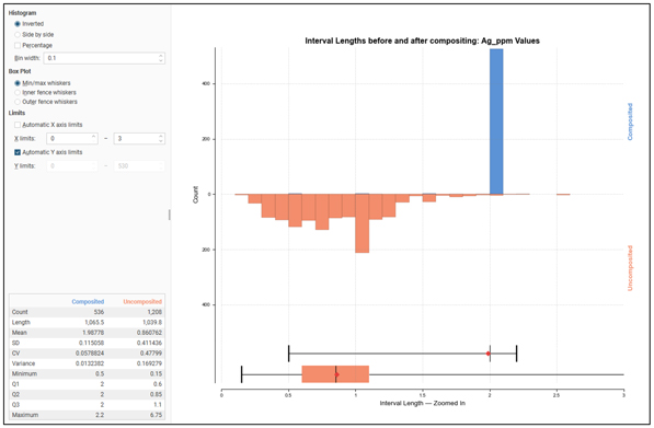
Note: Figure prepared by First Majestic, May 2025.
| 14.2.6. | Evaluation of Composite Sample Outlier Values |
Drill hole and channel composite samples were evaluated for high-grade outliers and those outliers were capped to values considered appropriate for estimation. Outlier values at the high end of the grade distributions were identified for silver from analysis of histograms, log cumulative probability, mean variance, and cumulative metal plots. The spatial distribution of outlier values was also considered. Figure 14-9 is an example of outlier value analysis for Cuerpo Ojuelas. To quantify the impact of capping, the estimate was evaluated to assess the change in metal content for the estimation due to capping. Table 14-5 to Table 14-7 show the declustered composite statistics for outlier value capping.
| 98 | September 2025 |
| La Encantada Silver Mine Coahuila, Mexico NI 43-101 Technical Report on Mineral Resource and Mineral Reserve Estimates |
|
Figure 14-9: Example of Global Analysis of Outlier Values, Cuerpo Ojuelas
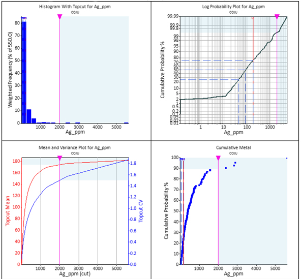
Note: Figure prepared by First Majestic, May 2025.
Table 14-5: Declustered Composite Sample Capping Statistics by Domain, Prieta Complex
| Assay |
Ag g/t | |||||||||||||||||||||||||||||||||||||||||||||||
| Resource Domain |
COJU | COJU_Skn | COJ2 | C660 | C660_Skn | CASNF | CF35 | CLFE | VDESC | VDESD | KaGS | SknGS | ||||||||||||||||||||||||||||||||||||
| Number of Samples |
550 | 71 | 235 | 66 | 88 | 399 | 35 | 201 | 146 | 48 | 287 | 439 | ||||||||||||||||||||||||||||||||||||
| Maximum Value |
5623 | 902 | 3401 | 2664 | 1471 | 814 | 742 | 2138 | 2212 | 760 | 408 | 1653 | ||||||||||||||||||||||||||||||||||||
| Mean |
170 | 112 | 143 | 200 | 149 | 33 | 140 | 131 | 78 | 62 | 45 | 62 | ||||||||||||||||||||||||||||||||||||
| Number Capped |
4 | 3 | 6 | 2 | 1 | 3 | 2 | 6 | 4 | 3 | 2 | 5 | ||||||||||||||||||||||||||||||||||||
| Capping Value |
2000 | 600 | 800 | 800 | 850 | 450 | 500 | 600 | 650 | 400 | 300 | 650 | ||||||||||||||||||||||||||||||||||||
| Mean Capped |
163 | 109 | 115 | 165 | 146 | 32 | 127 | 107 | 64 | 54 | 45 | 60 | ||||||||||||||||||||||||||||||||||||
| Mean Change % |
-5 | % | -3 | % | -19 | % | -17 | % | -2 | % | -1 | % | -9 | % | -19 | % | -17 | % | -13 | % | -1 | % | -3 | % | ||||||||||||||||||||||||
Note: Domains with relatively few samples are sensitive to value capping.
| 99 | September 2025 |
| La Encantada Silver Mine Coahuila, Mexico NI 43-101 Technical Report on Mineral Resource and Mineral Reserve Estimates |
|
Table 14-6: Declustered Composite Sample Capping Statistics by Domain, San Javier Milagros Complex
| Assay |
Ag g/t | |||||||||||||||
| Resource Domain |
C310 | CMLX | CMLI | CBXI | ||||||||||||
| Number of Samples |
4447 | 2001 | 1626 | 676 | ||||||||||||
| Maximum Value |
31608 | 8140 | 4763 | 896 | ||||||||||||
| Mean |
516 | 268 | 82 | 77 | ||||||||||||
| Number Capped |
22 | 14 | 9 | 0 | ||||||||||||
| Capping Value |
7000 | 3000 | 2000 | 896 | ||||||||||||
| Mean Capped |
494 | 259 | 77 | 77 | ||||||||||||
| Mean Change % |
-4 | % | -3 | % | -6 | % | 0 | % | ||||||||
Table 14-7: Declustered Composite Sample Capping Statistics by Domain, Vein Systems and Tailings
| Assay |
Ag g/t | |||||||||||||||||||||||||||||||||||||||||||
| Resource Domain |
VCNJ | VCN2_W | VCN2_E | VCNS | VOJS | CBN2 | CBN3 | VBNZ | VDBN | VDSF | VAYO | |||||||||||||||||||||||||||||||||
| Number of Samples |
950 | 312 | 421 | 103 | 177 | 125 | 145 | 237 | 174 | 1275 | 534 | |||||||||||||||||||||||||||||||||
| Maximum Value |
20658 | 684 | 9552 | 2019 | 1164 | 346 | 323 | 1000 | 514 | 5110 | 2547 | |||||||||||||||||||||||||||||||||
| Mean |
243 | 40 | 134 | 181 | 92 | 68 | 59 | 115 | 43 | 172 | 174 | |||||||||||||||||||||||||||||||||
| Number Capped |
65 | 2 | 6 | 1 | 4 | 5 | 3 | 7 | 2 | 11 | 4 | |||||||||||||||||||||||||||||||||
| Capping Value |
1200 | 300 | 2800 | 1200 | 800 | 225 | 250 | 600 | 400 | 2000 | 1500 | |||||||||||||||||||||||||||||||||
| Mean Capped |
169 | 38 | 112 | 180 | 91 | 64 | 58 | 112 | 43 | 167 | 171 | |||||||||||||||||||||||||||||||||
| Mean Change % |
-30 | % | -3 | % | -17 | % | -1 | % | -1 | % | -5 | % | -2 | % | -2 | % | 0 | % | -3 | % | -2 | % | ||||||||||||||||||||||
| Resource Domain |
C236 | CMAR | CREG | V990 | V990-2 | VREG | VBNA | VBN2 | VBN4 | VBN5 | TLN4 | |||||||||||||||||||||||||||||||||
| Number of Samples |
406 | 187 | 1621 | 1355 | 860 | 391 | 895 | 471 | 131 | 167 | 386 | |||||||||||||||||||||||||||||||||
| Maximum Value |
5092 | 2254 | 17167 | 9803 | 2762 | 4761 | 3250 | 11531 | 2109 | 3754 | 248 | |||||||||||||||||||||||||||||||||
| Mean |
96 | 120 | 234 | 235 | 132 | 341 | 142 | 325 | 158 | 240 | 112 | |||||||||||||||||||||||||||||||||
| Number Capped |
3 | 2 | 9 | 12 | 5 | 3 | 2 | 5 | 3 | 1 | 3 | |||||||||||||||||||||||||||||||||
| Capping Value |
830 | 1000 | 5000 | 4000 | 1400 | 3300 | 2500 | 7500 | 1500 | 1800 | 156 | |||||||||||||||||||||||||||||||||
| Mean Capped |
90 | 114 | 221 | 227 | 129 | 336 | 141 | 318 | 153 | 231 | 111 | |||||||||||||||||||||||||||||||||
| Mean Change % |
-6 | % | -4 | % | -6 | % | -4 | % | -2 | % | -2 | % | 0 | % | -2 | % | -3 | % | -4 | % | -1 | % | ||||||||||||||||||||||
Capping of composite sample values was limited to a select few extreme values. To reduce bias from additional high-grade samples, those outlier values were range restricted. Samples above a specified high-grade threshold value are used at full value out to a specified distance from the sample. Beyond the specified distance the samples are reduced in value to a stated high-grade threshold value.
| 14.2.7. | Composite Sample Statistics |
To assess the statistical character of the composite samples within each of the domains, the data were declustered by a cell declustering method. The silver declustered statistics of composite samples for all estimation domains are presented in Figure 14-10 and Table 14-8 for the Prieta complex, in Figure 14-11 and Table 14-9 for the San Javier-Milagros complex, and in Figure 14-12 and Table 14-10 for the Vein systems and the Tailings Deposit No 4.
| 100 | September 2025 |
| La Encantada Silver Mine Coahuila, Mexico NI 43-101 Technical Report on Mineral Resource and Mineral Reserve Estimates |
|
Figure 14-10: Ag Box Plots of Declustered Composite Sample Statistics by Domain, Prieta Complex
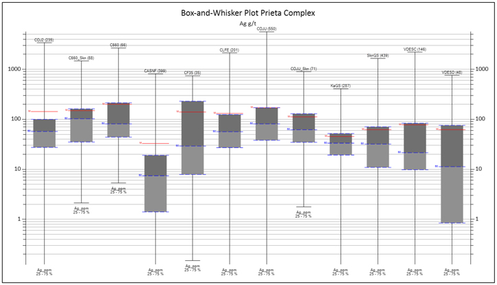
Note: Figure prepared by First Majestic, May 2025.
Table 14-8: Ag Declustered Composite Sample Statistics by Domain, Prieta Complex
| Assay |
Ag g/t | |||||||||||||||||||||||||||||||||||||||||||||||
| Resource Domain |
COJU | COJU_Skn | COJ2 | C660 | C660_Skn | CASNF | CF35 | CLFE | VDESC | VDESD | KaGS | SknGS | ||||||||||||||||||||||||||||||||||||
| Number of Samples |
550 | 71 | 235 | 66 | 88 | 399 | 35 | 201 | 146 | 48 | 287 | 439 | ||||||||||||||||||||||||||||||||||||
| Minimum Value |
0.125 | 1.77 | 0.125 | 5.35 | 2.13 | 0.125 | 0.150 | 0.125 | 0.125 | 0.125 | 0.125 | 0.125 | ||||||||||||||||||||||||||||||||||||
| Maximum Value |
5623 | 902 | 3401 | 2664 | 1471 | 814 | 742 | 2138 | 2212 | 760 | 408 | 1653 | ||||||||||||||||||||||||||||||||||||
| Mean |
170 | 112 | 143 | 200 | 149 | 33 | 140 | 131 | 78 | 62 | 45 | 62 | ||||||||||||||||||||||||||||||||||||
| Standard deviation |
335 | 136 | 331 | 358 | 176 | 71 | 202 | 271 | 214 | 127 | 48 | 106 | ||||||||||||||||||||||||||||||||||||
| CV |
1.96 | 1.21 | 2.31 | 1.79 | 1.18 | 2.15 | 1.44 | 2.06 | 2.75 | 2.04 | 1.07 | 1.71 | ||||||||||||||||||||||||||||||||||||
| Variance |
112066 | 18522 | 109454 | 127989 | 30834 | 4992 | 40670 | 73191 | 45595 | 16165 | 2336 | 11280 | ||||||||||||||||||||||||||||||||||||
| 101 | September 2025 |
| La Encantada Silver Mine Coahuila, Mexico NI 43-101 Technical Report on Mineral Resource and Mineral Reserve Estimates |
|
Figure 14-11: Ag Box Plot of Declustered Composite Sample Statistics by Domain, San Javier-Milagros Complex
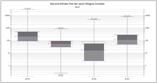
Note: Figure prepared by First Majestic, May 2025.
Table 14-9: Ag Declustered Composite Sample Statistics by Domain, San Javier Milagros Complex
| Assay |
Ag g/t | |||||||||||||||
| Resource Domain |
C310 | CMLX | CMLI | CBXI | ||||||||||||
| Number of Samples |
4447 | 2001 | 1626 | 676 | ||||||||||||
| Minimum Value |
0.125 | 0.125 | 0.125 | 0.250 | ||||||||||||
| Maximum Value |
31608 | 8140 | 4763 | 896 | ||||||||||||
| Mean |
516 | 268 | 82 | 77 | ||||||||||||
| Standard deviation |
1130 | 492 | 264 | 83 | ||||||||||||
| CV |
2.19 | 1.84 | 3.21 | 1.09 | ||||||||||||
| Variance |
1276068 | 241845 | 69778 | 6929 | ||||||||||||
Figure 14-12: Ag Box Plot of Declustered Composite Sample Statistics by Domain, Vein Systems and Tailings
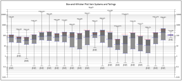
Note: Figure prepared by First Majestic, April 2025.
| 102 | September 2025 |
| La Encantada Silver Mine Coahuila, Mexico NI 43-101 Technical Report on Mineral Resource and Mineral Reserve Estimates |
|
Table 14-10: Ag Declustered Composite Sample Statistics by Domain, Vein Systems and Tailings
| Assay |
Ag g/t | |||||||||||||||||||||||||||||||||||||||||||
| Resource Domain |
VCNJ | VCN2_W | VCN2_E | VCNS | VOJS | CBN2 | CBN3 | VBNZ | VDBN | VDSF | VAYO | |||||||||||||||||||||||||||||||||
| Number of Samples |
950 | 312 | 421 | 103 | 177 | 125 | 145 | 237 | 174 | 1275 | 534 | |||||||||||||||||||||||||||||||||
| Minimum Value |
0.125 | 0.125 | 0.125 | 0.125 | 0.125 | 0.125 | 0.624 | 0.125 | 0.125 | 0.125 | 0.125 | |||||||||||||||||||||||||||||||||
| Maximum Value |
20658 | 684 | 9552 | 2019 | 1164 | 346 | 323 | 1000 | 514 | 5110 | 2547 | |||||||||||||||||||||||||||||||||
| Mean |
243 | 40 | 134 | 181 | 92 | 68 | 59 | 115 | 43 | 172 | 174 | |||||||||||||||||||||||||||||||||
| Standard deviation |
809 | 69 | 567 | 280 | 166 | 71 | 65 | 137 | 77 | 323 | 252 | |||||||||||||||||||||||||||||||||
| CV |
3.34 | 1.74 | 4.23 | 1.55 | 1.79 | 1.04 | 1.11 | 1.20 | 1.81 | 1.88 | 1.45 | |||||||||||||||||||||||||||||||||
| Variance |
654743 | 4708 | 321207 | 78560 | 27465 | 5014 | 4271 | 18898 | 6001 | 104164 | 63347 | |||||||||||||||||||||||||||||||||
| Resource Domain |
C236 | CMAR | CREG | V990 | V990-2 | VREG | VBNA | VBN2 | VBN4 | VBN5 | TLN4 | |||||||||||||||||||||||||||||||||
| Number of Samples |
406 | 187 | 1621 | 1355 | 860 | 391 | 895 | 471 | 131 | 167 | 386 | |||||||||||||||||||||||||||||||||
| Minimum Value |
0.125 | 0.125 | 0.125 | 0.125 | 0.125 | 0.125 | 0.125 | 0.125 | 6.8 | 0.125 | 64.7 | |||||||||||||||||||||||||||||||||
| Maximum Value |
5092 | 2254 | 17167 | 9803 | 2762 | 4761 | 3250 | 11531 | 2109 | 3754 | 248 | |||||||||||||||||||||||||||||||||
| Mean |
96 | 120 | 234 | 235 | 132 | 341 | 142 | 325 | 158 | 240 | 112 | |||||||||||||||||||||||||||||||||
| Standard deviation |
198 | 218 | 692 | 547 | 213 | 528 | 279 | 924 | 232 | 367 | 21 | |||||||||||||||||||||||||||||||||
| CV |
2.06 | 1.82 | 2.96 | 2.33 | 1.61 | 1.55 | 1.96 | 2.84 | 1.47 | 1.53 | 0.19 | |||||||||||||||||||||||||||||||||
| Variance |
39136 | 47395 | 478466 | 299716 | 45491 | 278813 | 77808 | 854392 | 53698 | 134790 | 428 | |||||||||||||||||||||||||||||||||
| 14.2.8. | Metal Trend and Spatial Analysis: Variography |
The dominant trends for silver mineralization were identified based on the 3D numeric models for the metal in each domain. Model variograms for silver composite values were developed along the trends identified and the nugget values were established from downhole variograms. Figure 14-13 displays an example of variogram plots for silver together with the variogram-oriented ellipsoid for the Cuerpo Ojuelas domain.
| 103 | September 2025 |
| La Encantada Silver Mine Coahuila, Mexico NI 43-101 Technical Report on Mineral Resource and Mineral Reserve Estimates |
|
Figure 14-13: Ag Variogram Models for Cuerpo Ojuelas
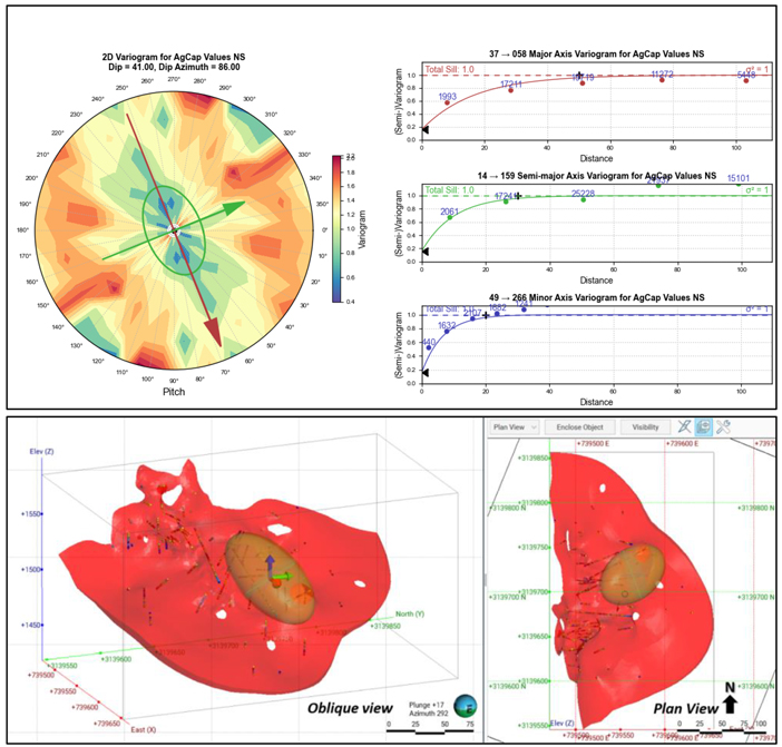
Note: Rotated View of Cuerpo Ojuelas with Silver Grade Trend and Variogram Ellipsoid Orientation. Figure prepared by First Majestic, May 2025.
| 14.2.9. | Bulk Density |
Bulk density for the mineral deposits at La Encantada were derived from SG core measurements. Bulk density for the resource domains was either estimated into the block models from the SG data or the mean SG value was assigned. The SG statistics for the Mineral Resource domains tabulated in Table 14-11.
| 104 | September 2025 |
| La Encantada Silver Mine Coahuila, Mexico NI 43-101 Technical Report on Mineral Resource and Mineral Reserve Estimates |
|
Table 14-11: SG Statistics by Resource Domain
| Resource Domains |
Resource Domain Code |
Count | Mean | Standard Deviation |
Coefficient of Variation |
Minimum | Median | Maximum | ||||||||||||||||||||||
| Cuerpo 310 |
C310 | 12 | 2.51 | 0.14 | 0.06 | 2.29 | 2.56 | 2.68 | ||||||||||||||||||||||
| Cuerpo 236 |
C236 | 4 | 2.42 | 0.11 | 0.05 | 2.29 | 2.43 | 2.56 | ||||||||||||||||||||||
| Cuerpo 660 Limestone |
C660 | 11 | 2.77 | 0.31 | 0.11 | 2.20 | 2.69 | 3.29 | ||||||||||||||||||||||
| Cuerpo 660 Skarn |
C660_Skn | 17 | 2.97 | 0.35 | 0.12 | 2.43 | 2.90 | 3.82 | ||||||||||||||||||||||
| Cuerpo Asuncion Falla |
CASNF | 21 | 2.72 | 0.30 | 0.11 | 2.16 | 2.77 | 3.55 | ||||||||||||||||||||||
| Cuerpo Bonanza 2 |
CBN2 | 13 | 2.38 | 0.32 | 0.13 | 1.67 | 2.49 | 2.85 | ||||||||||||||||||||||
| Cuerpo Bonanza 3 |
CBN3 | 17 | 2.57 | 0.25 | 0.10 | 2.18 | 2.55 | 3.18 | ||||||||||||||||||||||
| Cuerpo Intrusivo Milagros |
CMLI | 269 | 2.53 | 0.24 | 0.10 | 1.86 | 2.55 | 3.45 | ||||||||||||||||||||||
| Cuerpo Intrusivo Milagros Brecha |
CBXI | 65 | 2.63 | 0.43 | 0.16 | 1.65 | 2.60 | 3.61 | ||||||||||||||||||||||
| Cuerpo La Fe |
CLFE | 18 | 2.70 | 0.41 | 0.15 | 2.01 | 2.67 | 3.45 | ||||||||||||||||||||||
| Cuerpo Milagros Brecha |
CMLX | 112 | 2.55 | 0.27 | 0.11 | 1.96 | 2.53 | 3.67 | ||||||||||||||||||||||
| Cuerpo Ojuelas 2 |
COJ2 | 16 | 2.60 | 0.23 | 0.09 | 2.10 | 2.64 | 3.13 | ||||||||||||||||||||||
| Cuerpo Ojuelas Limestone |
COJU | 48 | 2.83 | 0.46 | 0.16 | 2.03 | 2.73 | 4.14 | ||||||||||||||||||||||
| Cuerpo Ojuelas Skarn |
COJU_Skn | 7 | 3.00 | 0.42 | 0.14 | 2.45 | 2.93 | 3.80 | ||||||||||||||||||||||
| Cuerpo Regalo |
CREG | 39 | 2.50 | 0.27 | 0.11 | 2.04 | 2.51 | 3.19 | ||||||||||||||||||||||
| Gradeshell Limestone |
KaGS | 11 | 2.89 | 0.38 | 0.13 | 2.43 | 2.71 | 3.50 | ||||||||||||||||||||||
| Gradeshell Skarn |
SknGS | 67 | 3.05 | 0.35 | 0.11 | 2.12 | 3.04 | 3.89 | ||||||||||||||||||||||
| Veta 990 |
V990 | 34 | 2.46 | 0.16 | 0.06 | 2.14 | 2.47 | 2.93 | ||||||||||||||||||||||
| Veta 990-2 |
V990-2 | 31 | 2.44 | 0.21 | 0.09 | 1.58 | 2.48 | 2.71 | ||||||||||||||||||||||
| Veta Azul y Oro |
VAYO | 15 | 2.53 | 0.13 | 0.05 | 2.38 | 2.51 | 2.90 | ||||||||||||||||||||||
| Veta Bonanza |
VBNZ | 23 | 2.41 | 0.30 | 0.13 | 1.79 | 2.39 | 3.24 | ||||||||||||||||||||||
| Veta Buenos Aires |
VBNA | 36 | 2.46 | 0.14 | 0.06 | 1.96 | 2.50 | 2.85 | ||||||||||||||||||||||
| Veta Buenos Aires 2 |
VBN2 | 25 | 2.48 | 0.23 | 0.09 | 1.83 | 2.51 | 3.21 | ||||||||||||||||||||||
| Veta Buenos Aires 4 |
VBN4 | 5 | 2.49 | 0.08 | 0.03 | 2.41 | 2.49 | 2.58 | ||||||||||||||||||||||
| Veta Buenos Aires 5 |
VBN5 | 11 | 2.50 | 0.11 | 0.04 | 2.33 | 2.49 | 2.78 | ||||||||||||||||||||||
| Veta Conejo |
VCNJ | 27 | 2.48 | 0.17 | 0.07 | 2.06 | 2.51 | 3.07 | ||||||||||||||||||||||
| Veta Conejo 2 East |
VCN2_E | 48 | 2.59 | 0.26 | 0.10 | 2.10 | 2.58 | 3.02 | ||||||||||||||||||||||
| Veta Conejo 2 West |
VCN2_W | 52 | 2.48 | 0.21 | 0.09 | 1.89 | 2.46 | 3.37 | ||||||||||||||||||||||
| Veta Conejo 4 (Ojitos) |
VOJS | 28.00 | 2.55 | 0.24 | 0.09 | 2.10 | 2.50 | 3.18 | ||||||||||||||||||||||
| Veta Dique Bonanza |
VDBN | 19 | 2.53 | 0.35 | 0.14 | 2.13 | 2.41 | 3.61 | ||||||||||||||||||||||
| Veta Dique Escondida |
VDESC | 7 | 2.77 | 0.38 | 0.14 | 2.37 | 2.54 | 3.32 | ||||||||||||||||||||||
| Veta Dique Escondida Splay |
VDESD | 4 | 2.62 | 0.14 | 0.05 | 2.51 | 2.56 | 2.80 | ||||||||||||||||||||||
| Veta Dique San Francisco |
VDSF | 52 | 2.43 | 0.18 | 0.08 | 1.92 | 2.45 | 2.93 | ||||||||||||||||||||||
| Veta El Regalo |
VREG | 16 | 2.45 | 0.24 | 0.10 | 1.96 | 2.38 | 2.82 | ||||||||||||||||||||||
| 14.2.10. | Block Model Setup |
A total of nine block models were used to estimate the resources. The block models were rotated so that the x and y axes lie parallel to the resource domain trend and the minimum-z direction is perpendicular to the trend. A sub-blocked model type was created that consists of primary parent blocks that are sub-divided into smaller sub-blocks whenever triggering surfaces intersect the parent blocks. The resource estimation domains and depletion boundaries served as such triggers. The size of the parent block considered the drill hole sample spacing and the mining methods. Silver grades were estimated into the
| 105 | September 2025 |
| La Encantada Silver Mine Coahuila, Mexico NI 43-101 Technical Report on Mineral Resource and Mineral Reserve Estimates |
|
parent blocks and resource domains were evaluated into the sub-blocks. The parameters for La Encantada block models are provided in Table 14-12.
Table 14-12: Block Model Parameters
| Parameters |
Azul y Oro |
Bonanza |
Buenos Aires |
Conejo |
990 |
|||||
| Base point: |
741040, 3140800, 2020 | 740075, 3140645, 2250 | 740530, 3140230, 1573 | 740870, 3141350, 2310 | 740050, 3140030, 1460 | |||||
| Parent block size (m): |
10 x 10 x 2 | 10 x 10 x 2 | 10 x 10 x 2 | 10 x 10 x 2 | 10 x 10 x 2 | |||||
| Sub-block mode: |
Octree | Octree | Octree | Octree | Octree | |||||
| Sub-blocking size (m): |
8 x 8 x 16 | 8 x 8 x 16 | 8 x 8 x 16 | 8 x 8 x 32 | 8 x 8 x 16 | |||||
| Minimum sub-block size (m): |
1.25, 1.25, 0.125 | 1.25, 1.25, 0.125 | 1.25, 1.25, 0.125 | 1.25, 1.25, 0.0625 | 1.25, 1.25, 0.125 | |||||
| Boundary size: |
690, 450, 126 | 840, 710, 214 | 670, 500, 186 | 1430, 830, 236 | 1400, 630, 212 | |||||
| Azimuth: |
146° | 322° | 321° | 141° | 324° | |||||
| Dip: |
82° | 87° | -90° | 86° | -90° | |||||
| Pitch: |
0° | 0° | 0° | 0° | 0° |
| Parameters |
Veta Dique San Francisco |
La Prieta Complex: Ojuelas-C660 |
La Prieta Complex: Other |
San Javier Milagros | Tailings | |||||||||||||||
| Base point: |
740870, 3141130, 2270 | 739290, 3139520, 1680 | 739060, 3139390, 1950 | 740030, 3140670, 2150 | 737400, 3140040, 1675 | |||||||||||||||
| Parent block size (m): |
10 x 10 x 2 | 5 x 5 x 5 | 5 x 5 x 5 | 5 x 5 x 5 | 12 x 12 x 16 | |||||||||||||||
| Sub-block mode: |
Octree | Octree | Octree | Octree | Octree | |||||||||||||||
| Sub-blocking size (m): |
8 x 8 x 16 | 8 x 8 x 8 | 8 x 8 x 8 | 4 x 4 x 8 | 4 x 4 x 8 | |||||||||||||||
| Minimum sub-block size (m): |
1.25, 1.25, 0.125 | 0.625, 0.625, 0.625 | 0.625, 0.625, 0.625 | 1.25, 1.25, 0.625 | 3, 3, 0.75 | |||||||||||||||
| Boundary size: |
1810, 860, 160 | 400, 365, 290 | 620, 430, 575 | 400, 280, 850 | 528, 456, 96 | |||||||||||||||
| Azimuth: |
133 | ° | 0 | ° | 0 | ° | 0 | ° | 0 | ° | ||||||||||
| Dip: |
78 | ° | 0 | ° | 0 | ° | 0 | ° | 0 | ° | ||||||||||
| Pitch: |
0 | ° | 0 | ° | 0 | ° | 0 | ° | 0 | ° | ||||||||||
| 14.2.11. | Block Model Estimation |
Silver estimates were completed for all domains at La Encantada. All block grades were estimated from composite samples captured within the respective resource domains. Following contact analysis, most domain contacts were treated as hard boundaries with some modified soft boundaries used for San Javier–Milagros domains.
Block grades were estimated primarily by inverse distance squared (ID2) and less commonly by ordinary kriging (OK). After inspection of the estimated gold and silver grades, many of the block models were judged to perform better with ID2 than with OK. The method selected in each case considered the characteristics of the domain, data spacing, variogram quality, and which method produced the best representation of grade continuity.
| 106 | September 2025 |
| La Encantada Silver Mine Coahuila, Mexico NI 43-101 Technical Report on Mineral Resource and Mineral Reserve Estimates |
|
All channel samples that were used during construction of the geological models were reviewed. Only those channels that completely cross the deposit were used during grade estimation. Channel samples that cross only a portion of the deposit were excluded as non-representative samples.
The production channel sampling method has some risk of non-representative sampling that could produce local grade bias. However, the substantial number of samples collected and used in the estimation may compensate for this issue and provide accurate results. There remains a risk that the channel samples could suffer from a systematic sampling issue that could also result in poor accuracy. These risks are recognized and addressed during resource grade estimation by eliminating the undue influence of channel samples over drill hole samples for blocks estimated at longer distances.
The grade estimation process was run in two successive passes whenever production channel samples were present. The first pass used all composites, including production channel samples, and only estimated blocks within a restricted short distance from the channel samples. Pass two applied less restrictive criteria using only drill hole composite samples. The silver estimation parameters for each of the estimation domains are presented in
| 107 | September 2025 |
| La Encantada Silver Mine Coahuila, Mexico NI 43-101 Technical Report on Mineral Resource and Mineral Reserve Estimates |
|
Table 14-13 to Table 14-16. Figure 14-14 shows an example of the two-pass estimation strategy using channel and drill hole composite samples for the Conejo domain.
| 108 | September 2025 |
| La Encantada Silver Mine Coahuila, Mexico NI 43-101 Technical Report on Mineral Resource and Mineral Reserve Estimates |
|
Table 14-13: Summary of Ag Estimation Parameters for the Prieta Complex Block Models
| Area |
Resource Domain Code |
Metal |
Estimator Name and |
Estimate Type |
Kriging Discretisation |
Ellipsoid Ranges | Ellipsoid Orientation |
No. of Samples |
Outlier Restrictions | Drillhole Limit | ||||||||||||||||||||||||||
| X | Y | Z | Maximum | Intermediate | Minimum | Variable Orientation |
Min | Max | Method | Distance | Threshold | Max Samples per Hole |
Apply Drillhole Limit per Sector |
|||||||||||||||||||||||
| Ojuelas- C660 |
COJU | Ag g/t | Ag: COJU, OK P1 | OK | 3 | 3 | 3 | 50 | 40 | 15 | VO COJU | 7 | 19 | Clamp | 50 | 1500 | 6 | FALSE | ||||||||||||||||||
| COJU | Ag g/t | Ag: COJU, OK P2 | OK | 3 | 3 | 3 | 100 | 80 | 20 | VO COJU | 4 | 19 | Clamp | 25 | 1500 | 6 | TRUE | |||||||||||||||||||
| COJU_Skn | Ag g/t | Ag: COJU_Skn, OK P1 | OK | 3 | 3 | 3 | 50 | 40 | 15 | VO COJU | 7 | 19 | Clamp | 50 | 500 | 6 | FALSE | |||||||||||||||||||
| COJU_Skn | Ag g/t | Ag: COJU_Skn, OK P2 | OK | 3 | 3 | 3 | 100 | 80 | 20 | VO COJU | 3 | 19 | Clamp | 25 | 500 | 6 | TRUE | |||||||||||||||||||
| COJ2 | Ag g/t | Ag: COJ2, OK P1 | OK | 3 | 3 | 3 | 50 | 40 | 15 | VO COJ2 | 7 | 19 | Clamp | 40 | 300 | 6 | FALSE | |||||||||||||||||||
| COJ2 | Ag g/t | Ag: COJ2, OK P2 | OK | 3 | 3 | 3 | 100 | 80 | 20 | VO COJ2 | 3 | 19 | Clamp | 20 | 300 | 6 | TRUE | |||||||||||||||||||
| C660 | Ag g/t | Ag: C660, OK P1 | OK | 3 | 3 | 3 | 75 | 50 | 20 | VO C660 | 7 | 19 | Clamp | 30 | 500 | 6 | TRUE | |||||||||||||||||||
| C660 | Ag g/t | Ag: C660, OK P2 | OK | 3 | 3 | 3 | 110 | 90 | 30 | VO C660 | 3 | 19 | Clamp | 20 | 500 | 6 | TRUE | |||||||||||||||||||
| C660_Skn | Ag g/t | Ag: C660_Skn, OK P1 | OK | 3 | 3 | 3 | 75 | 50 | 20 | VO C660 | 7 | 19 | Clamp | 30 | 500 | 6 | TRUE | |||||||||||||||||||
| C660_Skn | Ag g/t | Ag: C660_Skn, OK P2 | OK | 3 | 3 | 3 | 110 | 90 | 30 | VO C660 | 3 | 19 | Clamp | 20 | 500 | 6 | TRUE | |||||||||||||||||||
| VDESC | Ag g/t | Ag: VDESC, OK P1 | OK | 3 | 3 | 3 | 50 | 50 | 30 | VO VDESC | 7 | 19 | Clamp | 25 | 450 | 6 | TRUE | |||||||||||||||||||
| VDESC | Ag g/t | Ag: VDESC, OK P2 | OK | 3 | 3 | 3 | 100 | 100 | 40 | VO VDESC | 3 | 19 | Clamp | 25 | 450 | 6 | TRUE | |||||||||||||||||||
| VDESD | Ag g/t | Ag: VDESD, OK P1 | OK | 3 | 3 | 3 | 50 | 50 | 30 | VO VDESD | 7 | 20 | Clamp | 25 | 200 | 6 | TRUE | |||||||||||||||||||
| VDESD | Ag g/t | Ag: VDESD, OK P2 | OK | 3 | 3 | 3 | 100 | 100 | 40 | VO VDESD | 2 | 20 | Clamp | 30 | 200 | 4 | TRUE | |||||||||||||||||||
| KaGS | Ag g/t | Ag: KaGS, ID2 P1 | ID2 | 50 | 40 | 20 | VO KaGS | 7 | 15 | Clamp | 50 | 150 | 6 | FALSE | ||||||||||||||||||||||
| KaGS | Ag g/t | Ag: KaGS, ID2 P2 | ID2 | 100 | 80 | 30 | VO KaGS | 3 | 19 | Clamp | 25 | 150 | 6 | TRUE | ||||||||||||||||||||||
| SknGS | Ag g/t | Ag: SknGS, ID2 P1 | ID2 | 50 | 50 | 20 | VO SknGS | 7 | 19 | Clamp | 50 | 400 | 6 | TRUE | ||||||||||||||||||||||
| SknGS | Ag g/t | Ag: SknGS, ID2 P2 | ID2 | 100 | 100 | 40 | VO SknGS | 2 | 19 | Clamp | 25 | 400 | 6 | TRUE | ||||||||||||||||||||||
| Prieta Complex: Other |
CASNF | Ag g/t | Ag: CASNF, ID2 | ID2 | 120 | 100 | 40 | VO CASNF | 6 | 18 | Clamp | 30 | 200 | 5 | TRUE | |||||||||||||||||||||
| CF35 | Ag g/t | Ag: CF35, ID2 | ID2 | 70 | 60 | 40 | VO CF35 | 2 | 18 | Clamp | 30 | 150 | 6 | TRUE | ||||||||||||||||||||||
| CLFE | Ag g/t | Ag: CLFE, ID2 | ID2 | 120 | 100 | 20 | VO CLFE | 2 | 18 | Clamp | 25 | 200 | 6 | TRUE | ||||||||||||||||||||||
Note: P1 = Pass 1, P2 = Pass 2.
| 109 | September 2025 |
| La Encantada Silver Mine Coahuila, Mexico NI 43-101 Technical Report on Mineral Resource and Mineral Reserve Estimates |
|
Table 14-14: Summary of Ag Estimation Parameters for the San Javier Milagros Complex Block Models
| Area |
Resource Domain Code |
Metal |
Estimator Name and |
Estimate Type |
Capping Value |
Ellipsoid Ranges | Ellipsoid Directions |
Ellipsoid Orientation |
No. of Samples |
Outlier Restrictions | Drillhole Limit | |||||||||||||||||||||||||||
| Maximum | Intermediate | Minimum | Dip | Dip Azi. |
Pitch | Variable Orientation |
Min | Max | Method | Distance | Threshold | Max Samples per Hole |
Apply Drillhole Limit per Sector |
|||||||||||||||||||||||||
| San Javier Milagros Complex |
C310_MIL | Ag g/t | Ag: C310_DMIL, ID2 | ID2 | 9000 | 50 | 40 | 30 | 86 | 358 | 85 | None | 7 | 21 | Clamp | 20 | 5200 | None | TRUE | |||||||||||||||||||
| C310_N | Ag g/t | Ag: C310N, ID2 | ID2 | 12000 | 70 | 45 | 30 | 86 | 358 | 85 | None | 5 | 21 | Clamp | 20 | 5200 | None | TRUE | ||||||||||||||||||||
| C310_S | Ag g/t | Ag: C310S, ID2 | ID2 | 12000 | 70 | 40 | 30 | 86 | 358 | 85 | None | 7 | 21 | Clamp | 20 | 6000 | None | TRUE | ||||||||||||||||||||
| CBXI | Ag g/t | Ag: CBXI, ID2 | ID2 | 600 | 70 | 50 | 30 | 80 | 30 | 90 | None | 6 | 24 | Clamp | 20 | 420 | None | TRUE | ||||||||||||||||||||
| CMIL | Ag g/t | Ag: CMLI_Min, ID2 | ID2 | 2000 | 80 | 60 | 40 | 90 | 329 | 85 | None | 3 | 21 | Clamp | 20 | 1200 | None | TRUE | ||||||||||||||||||||
| CMLX | Ag g/t | Ag: CMLX, ID2 | ID2 | 2600 | 60 | 50 | 30 | 90 | 128 | 90 | None | 6 | 24 | None | None | TRUE | ||||||||||||||||||||||
Note: C310 estimated by three sub-domains with modified soft boundaries.
Table 14-15: Summary of Ag Estimation Parameters for Vein Systems Block Models
| Area |
Resource Domain Code |
Metal |
Estimator Name and |
Estimate Type |
Kriging Discretisation |
Ellipsoid Ranges | Ellipsoid Directions |
Ellipsoid Orientation |
No. of Samples |
Outlier Restrictions | Drillhole Limit | |||||||||||||||||||||||||||||||||
| X | Y | Z | Maximum | Intermediate | Minimum | Dip | Dip Azi. |
Pitch | Variable Orientation |
Min | Max | Method | Distance | Threshold | Max Samples per Hole |
Apply Drillhole Limit per Sector |
||||||||||||||||||||||||||||
| Azul y Oro |
VAYO | Ag g/t | Ag: VAYO, ID2 P1 ALL | ID2 | 20 | 20 | 20 | VO VAYO | 3 | 24 | None | None | None | 6 | FALSE | |||||||||||||||||||||||||||||
| VAYO | Ag g/t | Ag: VAYO, ID2 P2 DDH | ID2 | 100 | 100 | 70 | VO VAYO | 1 | 20 | Clamp | 20 | 500 | 4 | TRUE | ||||||||||||||||||||||||||||||
| Bonanza |
CBN2 | Ag g/t | Ag CBN2: ID2 | ID2 | 90 | 70 | 20 | VO CBN2 | 2 | 20 | None | 5 | FALSE | |||||||||||||||||||||||||||||||
| CBN3 | Ag g/t | Ag CBN3: ID2 | ID2 | 80 | 80 | 40 | VO CBN3 | 2 | 20 | None | 5 | FALSE | ||||||||||||||||||||||||||||||||
| VBNZ | Ag g/t | Ag VBNZ: ID2 P1 ALL | ID2 | 25 | 25 | 20 | VO VBNZ | 2 | 20 | Clamp | 20 | 450 | 5 | FALSE | ||||||||||||||||||||||||||||||
| VBNZ | Ag g/t | Ag VBNZ: ID2 P2 DDH | ID2 | 100 | 100 | 40 | VO VBNZ | 2 | 18 | Clamp | 20 | 350 | 4 | TRUE | ||||||||||||||||||||||||||||||
| VDBN | Ag g/t | Ag VDBN: ID2 P1 ALL | ID2 | 25 | 25 | 20 | VO VDBN | 2 | 20 | None | 5 | FALSE | ||||||||||||||||||||||||||||||||
| VDBN | Ag g/t | Ag VDBN: ID2 P2 DDH | ID2 | 90 | 90 | 20 | VO VDBN | 2 | 16 | Clamp | 25 | 250 | 5 | TRUE | ||||||||||||||||||||||||||||||
| Buenos Aires |
VBNA | Ag g/t | Ag: VBNA, ID2 P1 ALL | ID2 | 35 | 20 | 30 | VO VBNA | 8 | 31 | None | None | None | 7 | FALSE | |||||||||||||||||||||||||||||
| VBNA | Ag g/t | Ag: VBNA, ID2 P2 DDH | ID2 | 75 | 75 | 40 | VO VBNA | 1 | 20 | Clamp | 30 | 600 | TRUE | |||||||||||||||||||||||||||||||
| VBN2 | Ag g/t | Ag: VBN2, ID2 P1 ALL | ID2 | 25 | 15 | 25 | VO VBN2 | 3 | 20 | None | None | None | 7 | TRUE | ||||||||||||||||||||||||||||||
| VBN2 | Ag g/t | Ag: VBN2, ID2 P2 DDH | ID2 | 75 | 50 | 30 | VO VBN2 | 2 | 20 | None | None | None | 6 | TRUE | ||||||||||||||||||||||||||||||
| VBN4 | Ag g/t | Ag: VBN4, ID2 P1 ALL | ID2 | 15 | 15 | 25 | VO VBN4 | 5 | 25 | None | None | None | 6 | FALSE | ||||||||||||||||||||||||||||||
| VBN4 | Ag g/t | Ag: VBN4, ID2 P2 DDH | ID2 | 70 | 70 | 30 | VO VBN4 | 1 | 20 | None | None | None | TRUE | |||||||||||||||||||||||||||||||
| VBN5 | Ag g/t | Ag: VBN5, ID2 P1 ALL | ID2 | 30 | 30 | 30 | VO VBN5 | 6 | 18 | None | None | None | 5 | TRUE | ||||||||||||||||||||||||||||||
| VBN5 | Ag g/t | Ag: VBN5, ID2 P2 DDH | ID2 | 100 | 100 | 40 | VO VBN5 | 1 | 20 | None | None | None | TRUE | |||||||||||||||||||||||||||||||
| 110 | September 2025 |
| La Encantada Silver Mine Coahuila, Mexico NI 43-101 Technical Report on Mineral Resource and Mineral Reserve Estimates |
|
| Area |
Resource Domain Code |
Metal |
Estimator Name and |
Estimate Type |
Kriging Discretisation |
Ellipsoid Ranges | Ellipsoid Directions |
Ellipsoid Orientation |
No. of Samples |
Outlier Restrictions | Drillhole Limit | |||||||||||||||||||||||||||||||
| X | Y | Z | Maximum | Intermediate | Minimum | Dip | Dip Azi. |
Pitch | Variable Orientation |
Min | Max | Method | Distance | Threshold | Max Samples per Hole |
Apply Drillhole Limit per Sector |
||||||||||||||||||||||||||
| Conejo |
VCNJ | Ag g/t | Ag VCNJ: ID2, P1 ALL | ID2 | 20 | 20 | 20 | VO VCNJ | 7 | 30 | None | None | None | 6 | FALSE | |||||||||||||||||||||||||||
| VCNJ | Ag g/t | Ag VCNJ: ID2, P2 DDH | ID2 | 90 | 70 | 40 | VO VCNJ | 1 | 20 | None | None | None | 6 | TRUE | ||||||||||||||||||||||||||||
| VCN2_E | Ag g/t | Ag VCN2_FEE: ID2, P1 ALL | ID2 | 25 | 25 | 20 | VO VCN2 | 7 | 24 | None | None | None | 6 | FALSE | ||||||||||||||||||||||||||||
| VCN2_E | Ag g/t | Ag VCN2_FEE: ID2, P2 DDH | ID2 | 80 | 60 | 30 | VO VCN2 | 1 | 20 | Clamp | 28 | 2000 | 6 | TRUE | ||||||||||||||||||||||||||||
| VCN2_W | Ag g/t | Ag VCN2_FEW: ID2 | ID2 | 80 | 80 | 40 | VO VCN2 | 1 | 20 | None | None | None | 6 | TRUE | ||||||||||||||||||||||||||||
| VOJS | Ag g/t | Ag VOJS: ID2 P1 ALL | ID2 | 25 | 15 | 10 | VO VOJS | 5 | 20 | None | None | None | 3 | TRUE | ||||||||||||||||||||||||||||
| VOJS | Ag g/t | Ag VOJS: ID2 P2 DDH | ID2 | 160 | 120 | 40 | VO VOJS | 1 | 20 | Clamp | 20 | 550 | 6 | TRUE | ||||||||||||||||||||||||||||
| VCNS | Ag g/t | Ag VCNS: ID2, P1 ALL | ID2 | 18 | 15 | 15 | VO VCNS | 7 | 30 | None | None | None | 6 | FALSE | ||||||||||||||||||||||||||||
| VCNS | Ag g/t | Ag VCNS: ID2, P2 DDH | ID2 | 90 | 70 | 40 | VO VCNS | 1 | 20 | Clamp | 20 | 600 | 6 | TRUE | ||||||||||||||||||||||||||||
| 990 |
C236 | Ag g/t | Ag: C236, ID2 P1 ALL | ID2 | 25 | 25 | 25 | VO C236 | 6 | 18 | None | None | None | 6 | TRUE | |||||||||||||||||||||||||||
| C236 | Ag g/t | Ag: C236, ID2 P2 DDH | ID2 | 70 | 70 | 20 | VO C236 | 1 | 18 | Clamp | 30 | 400 | 6 | TRUE | ||||||||||||||||||||||||||||
| CMAR | Ag g/t | Ag: CMAR, ID2 P1 ALL | ID2 | 50 | 50 | 40 | 0 | 0 | 90 | None | 1 | 18 | Clamp | 40 | 400 | 6 | TRUE | |||||||||||||||||||||||||
| CREG | Ag g/t | Ag: CREG, ID2 P1 ALL | ID2 | 35 | 35 | 35 | 90 | 324 | 100 | None | 5 | 25 | None | None | None | TRUE | ||||||||||||||||||||||||||
| CREG | Ag g/t | Ag: CREG, ID2 P2 DDH | ID2 | 100 | 100 | 40 | 90 | 324 | 100 | None | 1 | 20 | None | None | None | TRUE | ||||||||||||||||||||||||||
| V990 | Ag g/t | Ag: V990, Kr P1 ALL | OK | 3 | 3 | 3 | 35 | 35 | 35 | VO V990 | 6 | 24 | None | None | None | 5 | TRUE | |||||||||||||||||||||||||
| V990 | Ag g/t | Ag: V990, Kr P2 DDH | OK | 3 | 3 | 3 | 110 | 100 | 40 | VO V990 | 1 | 18 | Clamp | 25 | 800 | 6 | TRUE | |||||||||||||||||||||||||
| V990-2 | Ag g/t | Ag: V990-2, Kr P1 ALL | OK | 3 | 3 | 3 | 35 | 35 | 35 | VO V990-2 | 8 | 24 | None | None | None | 6 | FALSE | |||||||||||||||||||||||||
| V990-2 | Ag g/t | Ag: V990-2, Kr P2 DDH | OK | 3 | 3 | 3 | 75 | 75 | 30 | VO V990-2 | 1 | 20 | None | None | None | 6 | TRUE | |||||||||||||||||||||||||
| VREG | Ag g/t | Ag: VREG, ID2 P1 ALL | ID2 | 35 | 35 | 35 | VO VREG | 8 | 30 | None | None | None | 6 | FALSE | ||||||||||||||||||||||||||||
| VREG | Ag g/t | Ag: VREG, ID2 P2 DDH | ID2 | 100 | 100 | 40 | VO VREG | 1 | 18 | Clamp | 30 | 600 | 6 | TRUE | ||||||||||||||||||||||||||||
| San Francisco |
VDSF | Ag g/t | Ag VDSF, Kr P1 ALL | OK | 3 | 3 | 3 | 28 | 28 | 20 | VO VDSF | 6 | 18 | None | None | None | 5 | FALSE | ||||||||||||||||||||||||
| VDSF | Ag g/t | Ag VDSF, Kr P2 DDH | OK | 3 | 3 | 3 | 110 | 100 | 30 | VO VDSF | 1 | 20 | Clamp | 20 | 1000 | 6 | TRUE | |||||||||||||||||||||||||
Note: VCN2 consists of FEE and FEW sub-domains. P1 = Pass 1, P2 = Pass 2.
| 111 | September 2025 |
| La Encantada Silver Mine Coahuila, Mexico NI 43-101 Technical Report on Mineral Resource and Mineral Reserve Estimates |
|
Table 14-16: Summary of Ag Estimation Parameters for the Tailings Block Model
| Area |
Resource Domain Code |
Metal | Estimator Name and Pass |
Estimate Type |
Capping Value |
Kriging Discretisation |
Ellipsoid Ranges | Ellipsoid Directions |
Ellipsoid Orientation |
No. of Samples |
Outlier Restrictions | Drillhole Limit | ||||||||||||||||||||||||||||||||||
| X | Y | Z | Maximum | Intermediate | Minimum | Dip | Dip Azi. |
Pitch | Variable Orientation |
Min | Max | Method | Distance | Threshold | Max Samples per Hole |
Apply Drillhole Limit per Sector |
||||||||||||||||||||||||||||||
| Tailings No.4 |
TLN4_L | Ag g/t | Ag: Tailings_Lower |
OK | 156 | 3 | 3 | 3 | 125 | 125 | 30 | 5 | 280 | 82 | None | 4 | 20 | None | None | None | 4 | TRUE | ||||||||||||||||||||||||
| TLN4_U | Ag g/t | Ag: Tailings_Upper |
OK | 156 | 3 | 3 | 3 | 125 | 125 | 30 | 5 | 280 | 82 | None | 4 | 20 | None | None | None | 4 | TRUE | |||||||||||||||||||||||||
| 112 | September 2025 |
| La Encantada Silver Mine Coahuila, Mexico NI 43-101 Technical Report on Mineral Resource and Mineral Reserve Estimates |
|
Figure 14-14: An Example of 2-Pass Estimation Strategy used for the VCNJ Domain,
Vertical Section with Plan View Reference to the Right
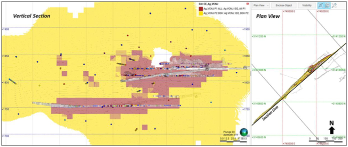
Note: Composite samples densely arrayed horizontally are production channel samples from underground mine developments. Pass 1 in red, Pass 2 in yellow. Figure prepared by First Majestic, May 2025.
| 14.2.12. | Block Model Validation |
Validation of the silver estimation was completed for each of the domains. The procedure was conducted as follows:
| • | Comparison of wireframe domain volumes to block model volumes for the domains; |
| • | Visual inspection comparing the composite sample grades to the estimated block values; |
| • | Comparison of the silver grades in “well-informed” parental blocks to the average sample values of the composited samples contained within those blocks using scatter plots; |
| • | Comparison of the global mean declustered composite sample grades to the block model mean grade for each resource domain and review of the impact from clustering in the composite sample data set; |
| • | Comparison of local block grade trends to composited sample grades along the three block model axes (i.e., easting, northing, and elevation) with swath grade trend plots. |
The silver block grades were visually inspected in vertical section. This review showed that the supporting composite sample grades closely match the estimated block values. Figure 14-15 and Figure 14-16 show examples of the estimated block model silver grades together with the composite sample grades for the Cuerpo Ojuelas and Tailings Deposit No. 4 domains.
| 113 | September 2025 |
| La Encantada Silver Mine Coahuila, Mexico NI 43-101 Technical Report on Mineral Resource and Mineral Reserve Estimates |
|
Figure 14-15: Visual Inspection of Cuerpo Ojuelas Ag Block Model Estimates and Composite Sample Values, Vertical Section and Plan View
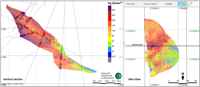
Note: Figure prepared by First Majestic, April 2025.
Figure 14-16: Visual Inspection of Tailings Deposit No. 4 Ag Block Model Estimate and Composite Sample Values, Vertical Section and Plan View
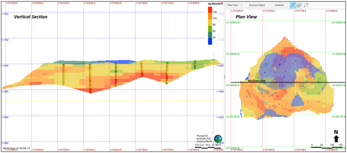
Note: Figure prepared by First Majestic, April 2025.
Estimated block grades display conditional bias with higher grades underestimated, lower grades over-estimated, and estimated extreme grades tending to be smoother. Scatterplot comparison of the estimated grades in “well-informed” parent blocks to the average composite sample values contained within those blocks illustrates the conditional bias for the estimate. The scatterplot example from the Cuerpo Milagros Breccia domain in Figure 14-17 demonstrates that the estimated block grades correlate well with the composite sample grades, and that the estimated grades are variable and not overly smooth.
| 114 | September 2025 |
| La Encantada Silver Mine Coahuila, Mexico NI 43-101 Technical Report on Mineral Resource and Mineral Reserve Estimates |
|
Figure 14-17: Conditional Bias Scatterplot of Ag Composite and Estimated Ag Block Values, Cuerpo Milagros Breccia
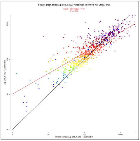
Note: Figure prepared by First Majestic, May 2025.
The global estimated mean grades were checked for bias by comparing the estimated grade of the resource domains to the supporting composite data. The mean estimated block model grades are a close match to the declustered mean value for the capped composite samples, and the block model estimates show reasonable bias. Figure 14-18 is an example of a bar plot for mean estimated block and composite grades for the resource domains in the Prieta complex.
| 115 | September 2025 |
| La Encantada Silver Mine Coahuila, Mexico NI 43-101 Technical Report on Mineral Resource and Mineral Reserve Estimates |
|
Figure 14-18: Global Mean Ag Grade Bias Check for Resource Domains of the Prieta Complex Comparing Raw Assay to Declustered Composite Mean Grades and Mean Block Grades
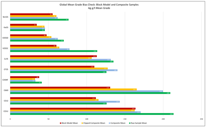
Note: Raw composite mean is not declustered. Composite and clipped (capped) composite means are declustered.
COJU = Cuerpo Ojuelas. Figure prepared by First Majestic, April 2025.
The block model estimates were also validated by comparing the estimated block grades for silver to nearest neighbour block estimates (NN) and to the composite sample values in swath plots oriented in three directions (composite samples averages are not declustered). The mean estimated block grades, NN grades, and composite sample grades are similar in all directions for all resource domains. The swath plots for Cuerpo Ojuelas silver grades in y and z directions are shown in Figure 14-19.
| 116 | September 2025 |
| La Encantada Silver Mine Coahuila, Mexico NI 43-101 Technical Report on Mineral Resource and Mineral Reserve Estimates |
|
Figure 14-19: Ag Mean Value Swath Plot Across Cuerpo Ojuelas in Y and Z
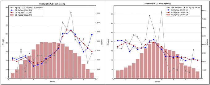
Note: Gray line is clipped composite sample values. Figure prepared by First Majestic, April 2025.
Overall, the block model validations demonstrate that the current resource estimates are a reasonable representation of the primary input sample data.
| 14.2.13. | Mineral Resource Classification |
Block model resource estimates were classified according to the 2014 “CIM Definition Standards for Mineral Resources & Mineral Reserves” using industry best practices as outlined in the 2019 “CIM Estimation of Mineral Resources and Mineral Reserves Best Practice Guidelines”. Best practices in the industry recommend that the classification of resources should consider the resource geologist’s confidence in the geological interpretation and model; confidence in the grade continuity for the mineralized domains; and the measure of sample support along with the quality of the sample data. Appropriate classification strategy integrates these concepts to delineate areas of similar confidence and risk.
Mineral Resources were classified into Indicated or Inferred categories based on the following factors:
| • | Confidence in the geological interpretation and models; |
| • | Confidence in the continuity of metal grades; |
| • | The sample support for the estimation and reliability of the sample data; |
| • | Areas that were mined producing reliable production channel samples and detailed geological control. |
The method used to measure the sample support used for the Mineral Resource classification was the nominal drill hole spacing. The nominal drill hole spacing was produced by an estimation pass for each block in the model that used three composite samples with a maximum of one sample per drill hole, which requires three separate drill holes. The average distance for each block to the three closest drill holes was
| 117 | September 2025 |
| La Encantada Silver Mine Coahuila, Mexico NI 43-101 Technical Report on Mineral Resource and Mineral Reserve Estimates |
|
estimated, and then the nominal drill hole spacing was estimated by dividing the average distance to drill holes by 0.7.
The blocks for all resource domains were flagged to be considered for either Indicated or Inferred categories if the nominal drill hole spacing for the block was less than a specified distance, which was selected to reflect the geologist’s confidence in the geological and grade continuity. The minimum distance threshold to the nearest drill hole was also used to include blocks surrounding drill holes on the perimeter of a region flagged by nominal drill hole spacing. Generally, blocks were flagged of the Indicated class if the drill hole spacing was less than 35-45 m and flagged for Inferred class if the drill hole spacing was less than 60-70 m. The presence of underground mining and mapping also supported Indicated category classification.
Wireframes were constructed to encompass block model zones for Indicated and Inferred categories. This process allowed for review of the geological confidence for the estimates, together with drill hole support, and expanded certain areas but excluded others from the classification. Blocks were finally assigned to a classification category by the respective wireframe if the centroid of the block fell inside the wireframe. Figure 14-20 is a long section showing an example of Indicated and Inferred Mineral Resource categories for the Veta Dique San Francisco domain.
Figure 14-20: Indicated and Inferred Mineral Resource Categories, Veta Dique San Francisco Domain
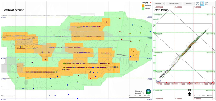
Note: Composite samples used for the estimation and underground mine developments are also shown. Section and plan views. Figure prepared by First Majestic, April 2025.
14.2.14. Reasonable Prospects for Eventual Economic Extraction
The Mineral Resource estimates were evaluated for reasonable prospects for eventual economic extraction by application of input parameters based on mining and processing information from the last
| 118 | September 2025 |
| La Encantada Silver Mine Coahuila, Mexico NI 43-101 Technical Report on Mineral Resource and Mineral Reserve Estimates |
|
12 months of mining operations. Economic parameters including operating costs, metallurgical recovery, metal prices and other parameters were used as follows:
• Direct mining cost: dependent on mining method; |
||
• Cut-and-fill |
$65.08/t; | |
• Longhole stoping |
$47.38/t; | |
• Sub-level inclined caving |
$32.46/t; | |
• G&A and indirect mining cost |
$13.44/tonne; | |
• Sustaining cost |
$6.47/tonne; | |
• Ag metallurgical recovery |
66.2%; | |
• Ag payable |
99.6%; | |
• Ag metal price |
US$28.00/oz; | |
These economic parameters result in a silver cut-off grade of:
| • | 150 g/t Ag for narrow thickness veins expected to be extracted by cut-and-fill; |
| • | 105 g/t Ag for medium thickness veins expected to be extracted by longhole stoping; |
| • | 80 g/t Ag for breccia pipes and massive lens deposits expected to be extracted by sub-level inclined caving. |
The economic parameters including operating costs, metallurgical recovery, metal prices and other parameters for the Tailings Deposit No. 4 are as follows:
• Direct mining cost: |
$45.69/t |
|
• G&A and indirect mining cost |
$2.49/t; |
|
• Ag metallurgical recovery |
70.0%; |
|
• Ag payable |
99.6%; |
|
• Ag metal price |
US$28.00 /oz. |
These economic parameters for Tailings Deposit No. 4 result in an Ag cut-off grade of 108 g/t Ag.
Deswik Stope Optimizer software was used to identify the blocks that represent underground mineable volumes that exceed the cut-off value while complying with the aggregate of economic parameters. This tool allows blocks to be aggregated into the minimum stope dimensions and eliminate outliers that do not comply with these conditions. A similar approach was set up for the Vein Systems following a methodology based on a set of calculations in the block model. The variables used were the true thickness from each vein, the minimum mining width, and the cut-off grade depending on the mining method. Results from this methodology were validated against the stope optimization in Deswik and were found to produce near identical results.
| 119 | September 2025 |
| La Encantada Silver Mine Coahuila, Mexico NI 43-101 Technical Report on Mineral Resource and Mineral Reserve Estimates |
|
| 14.2.15. | Mining Depletion |
Models of the underground mining excavations were evaluated into the block models for all domains. These modeled volumes were used to deplete the block model Mineral Resource estimates prior to reporting the resources. Regions within the mine such as unmined pillars that are in situ but judged to be un-mineable were also removed from the estimates. Figure 14-21 shows an example for underground mining excavations at the Prieta Complex, C660 area.
Figure 14-21: Block Model Example of Underground Mining Excavations at the Prieta Complex, C660 Area
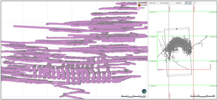
Note: 3D view looking south and plan view. Figure prepared by First Majestic, April 2025.
| 120 | September 2025 |
| La Encantada Silver Mine Coahuila, Mexico NI 43-101 Technical Report on Mineral Resource and Mineral Reserve Estimates |
|
| 14.3. | Statement of Mineral Resource Estimates |
Mineral Resources are reported assuming underground mining methods except for the Tailings Deposit No. 4. Cut-off grades appropriate for the selected mining method are assigned to each domain. All Mineral Resources are reported using the 2014 CIM Definition Standards with an effective date of December 31, 2024.
| 121 | September 2025 |
| La Encantada Silver Mine Coahuila, Mexico NI 43-101 Technical Report on Mineral Resource and Mineral Reserve Estimates |
|
Table 14-17 summarizes the reporting groups for the resource domains included in the Mineral Resource estimate and the selected mining method for each domain.
| 122 | September 2025 |
| La Encantada Silver Mine Coahuila, Mexico NI 43-101 Technical Report on Mineral Resource and Mineral Reserve Estimates |
|
Table 14-17: Mineral Resource Estimate Statement Reporting Groups for La Encantada with Associated Mining Method
| Reporting Groups | Resource Domains | Resource Domain Code |
Mining Method | |||
|
Prieta Complex: Ojuelas-C660 |
Cuerpo 660 Limestone | C660 | Sub-level inclined caving | |||
| Cuerpo 660 Skarn | C660_Skn | Sub-level inclined caving | ||||
| Cuerpo Ojuelas Limestone | COJU | Sub-level inclined caving | ||||
| Cuerpo Ojuelas Skarn | COJU_Skn | Sub-level inclined caving | ||||
| Cuerpo Ojuelas 2 | COJ2 | Sub-level inclined caving | ||||
| Gradeshell Limestone | KaGS | Sub-level inclined caving | ||||
| Gradeshell Skarn | SknGS | Sub-level inclined caving | ||||
| Veta Dique Escondida | VDESC | Sub-level inclined caving | ||||
|
Prieta Complex: Other |
Cuerpo La Fe | CLFE | Longhole stoping | |||
| Cuerpo Falla 35 | CF35 | Longhole stoping | ||||
| Cuerpo Asuncion Falla | CASNF | Longhole stoping | ||||
|
Vein Systems |
Cuerpo 236 | C236 | Longhole stoping | |||
| Cuerpo Bonanza 2 | CBN2 | Longhole stoping | ||||
| Cuerpo Bonanza 3 | CBN3 | Longhole stoping | ||||
| Cuerpo Marisela | CMAR | Sub-level inclined caving | ||||
| Cuerpo Regalo | CREG | Sub-level inclined caving | ||||
| Veta 990 | V990 | Cut and fill | ||||
| Veta 990-2 | V990-2 | Cut and fill | ||||
| Veta Azul y Oro | VAYO | Cut and fill | ||||
| Veta Bonanza | VBNZ | Longhole stoping | ||||
| Veta Buenos Aires | VBNA | Cut and fill | ||||
| Veta Buenos Aires 2 | VBN2 | Cut and fill | ||||
| Veta Buenos Aires 4 | VBN4 | Cut and fill | ||||
| Veta Buenos Aires 5 | VBN5 | Cut and fill | ||||
| Veta Conejo | VCNJ | Cut and fill | ||||
| Veta Conejo 2 | VCN2 | Cut and fill | ||||
| Veta Conejo 4 (Ojitos) | VOJS | Cut and fill | ||||
| Veta Conejo Splay | VCNS | Cut and fill | ||||
| Veta Dique Bonanza | VDBN | Cut and fill | ||||
| Veta Dique San Francisco | VDSF | Sub-level inclined caving | ||||
| Veta El Regalo | VREG | Cut and fill | ||||
|
San Javier Milagros Complex |
Cuerpo 310 | C310 | Sub-level inclined caving | |||
| Cuerpo Milagros Brecha | CMLX | Sub-level inclined caving | ||||
| Cuerpo Intrusivo Milagros | CMLI | Sub-level inclined caving | ||||
| Cuerpo Intrusivo Milagros Brecha | CBXI | Sub-level inclined caving | ||||
|
Tailings Deposit No.4 |
Tailings Deposit No.4 | TLN4 | Tailings | |||
The consolidated Indicated and Inferred Mineral Resource estimates for La Encantada are provided in Table 14-18 and Table 14-19 respectively. Indicated Mineral Resources are reported inclusive of Mineral Reserves. Mineral Resources that are not Mineral Reserves do not have demonstrated economic viability.
| 123 | September 2025 |
| La Encantada Silver Mine Coahuila, Mexico NI 43-101 Technical Report on Mineral Resource and Mineral Reserve Estimates |
|
Table 14-18: La Encantada Mineral Resource Estimate Statement, Indicated Category
(effective date December 31, 2024)
| Category / Area |
Mineral Type |
Tonnage | Grades | Metal Content | ||||||||||||||
| k tonnes | Ag (g/t) | Ag (k Oz) | Ag-Eq (k Oz) | |||||||||||||||
| Indicated Ojuelas & Cuerpo 660 (UG) |
Oxides + Mixed | 1,100 | 193 | 6,830 | 6,830 | |||||||||||||
| Indicated Veins Systems (UG) |
Oxides | 892 | 273 | 7,820 | 7,820 | |||||||||||||
| Indicated San Javier Milagros Complex (UG) |
Oxides | 1,125 | 118 | 4,280 | 4,280 | |||||||||||||
| Indicated Tailings Deposit No. 4 |
Oxides | 2,773 | 118 | 10,510 | 10,510 | |||||||||||||
| Total Indicated (UG + Tailings) |
All Mineral Types | 5,890 | 155 | 29,440 | 29,440 | |||||||||||||
Table 14-19: La Encantada Mineral Resource Estimate Statement, Inferred Category
(effective date December 31, 2024)
| Category / Area |
Mineral Type | Tonnage | Grades | Metal Content | ||||||||||||||||
| k tonnes | Ag (g/t) | Ag (k Oz) | Ag-Eq (k Oz) | |||||||||||||||||
| Inferred Ojuelas & Cuerpo 660 (UG) |
Oxides + Mixed | 293 | 160 | 1,510 | 1,510 | |||||||||||||||
| Inferred Prieta Complex (UG) |
Oxides | 207 | 192 | 1,280 | 1,280 | |||||||||||||||
| Inferred Veins Systems (UG) |
Oxides | 1,260 | 237 | 9,610 | 9,610 | |||||||||||||||
| Inferred San Javier Milagros Complex (UG) |
Oxides | 219 | 96 | 670 | 670 | |||||||||||||||
| Inferred Tailings Deposit No. 4 |
Oxides | 458 | 117 | 1,730 | 1,730 | |||||||||||||||
| Total Inferred (UG + Tailings) |
All Mineral Types | 2,438 | 189 | 14,800 | 14,800 | |||||||||||||||
| (1) | Mineral Resource estimates are classified per CIM Definition Standards (2014) and NI 43-101. |
| (2) | Mineral Resource estimates are based on internal estimates with an effective date of December 31, 2024. |
| (3) | Mineral Resource estimates were supervised or reviewed by Karla Michelle Calderon Guevara, CPG, Internal Qualified Person for First Majestic, per NI 43-101. |
| (4) | The Silver-equivalent grade (Ag-Eq) equals the silver grade (Ag). |
| (5) | Metal price for mineral resource estimates was $28.0/oz Ag. |
| (6) | The cutoff grades used to constrain the Mineral Resource estimates are 80 g/t Ag for sub-level caving at Ojuelas, 150 g/t Ag for cut and fill at Conejo, 135 g/t Ag for cut and fill at Vein System (Buenos Aires, 990, Azul y Oro), 105 g/t Ag for bodies in the Vein System (Cuerpo El Regalo, Cuerpo Marisela), 105 g/t Ag for Longhole at Vein System (Bonanza, C236), 70 g/t Ag for bodies at Veta Dique San Francisco, 70 g/t for bodies at San Javier and Milagros Breccias, and 108 g/t Ag for Tailings Deposit No. 4. |
| (7) | Mineral Resources are reported within mineable stope shapes using the cutoff grade calculated using the stated metal prices and metal recoveries. |
| (8) | No dilution was applied to the Mineral Resource which are reported on an in-situ basis. |
| (9) | Tonnage is expressed in thousands of tonnes; metal content is expressed in thousands of ounces. Totals may not add up due to rounding. |
| (10) | Measured and Indicated Mineral Resources are reported inclusive of Mineral Reserves. Mineral Resources that are not Mineral Reserves do not have demonstrated economic viability. |
| 14.4. | Factors that May Affect the Mineral Resource Estimates |
Risk factors that could materially impact the Mineral Resource estimates include:
| • | Metal price and exchange rate assumptions; |
| • | Changes to the assumptions used to generate the silver cut-off grade (metallurgical recovery and cost assumptions); |
| 124 | September 2025 |
| La Encantada Silver Mine Coahuila, Mexico NI 43-101 Technical Report on Mineral Resource and Mineral Reserve Estimates |
|
| • | Changes in the interpretations of mineralization geometry and continuity of mineralized zones; |
| • | Changes to geological and mineralization shape and geological and grade continuity assumptions; |
| • | Changes to geotechnical and mining method assumptions; |
| • | Changes to the assumptions related to the continued ability to access the site, retain mineral and surface rights titles, maintain environment and other regulatory permits, and maintain the social license to operate; |
| • | The production channel sampling method has some risk of non-representative sampling that could result in poor accuracy locally. In addition, there is potential for the substantial number of channel samples to overwhelm samples from the drill holes in some areas. This is recognized and addressed during resource estimation by restricting the area of influence related to these samples to short ranges. |
| 14.5. | Comments on Section 14 |
The QP is of the opinion that the Mineral Resource estimates for La Encantada were estimated using industry best practices and conform to the 2014 CIM Definition Standards for Mineral Resources.
To the extent currently known, there are no environmental, permitting, legal, title, taxation, socio-economic, marketing, political, or other factors or risks that could materially affect the development of the mineral resources. Mineral Resources that are not Mineral Reserves do not have demonstrated economic viability.
| 125 | September 2025 |
| La Encantada Silver Mine Coahuila, Mexico NI 43-101 Technical Report on Mineral Resource and Mineral Reserve Estimates |
|
| 15. | MINERAL RESERVES ESTIMATES |
The Mineral Reserve estimates were prepared by Rebeca Barja, a First Majestic Senior Mining Engineer, under the supervision of Mr. Andrew Pocock, P.Eng., Director of Reserves for First Majestic. Mr. Pocock is the QP for these estimates.
| 15.1. | Mineral Reserves Estimation Methodology |
The Mineral Reserve estimation process involves converting Indicated Mineral Resources to Probable Mineral Reserves by identifying material that exceeds the mining cut-off grades and conforms to the geometrical constraints defined by the selected mining method. Modifying factors, such as mining methods, mining recovery, dilution, sterilization, depletion, cutoff grades, geotechnical conditions, metallurgical factors, infrastructure, operability, safety, environmental, regulatory, saleability of products, social and legal factors were considered. These factors were applied to produce mineable stope shapes.
Initial considerations for the conversion of Mineral Resources into Mineral Reserves include a review of the following aspects:
| • | Status of the mining concessions, and surface land agreements for access and operation; |
| • | Environmental aspects and permits in place that enable mining and processing of the mineralized material; |
| • | Condition and availability of the existing infrastructure and coordination for supplies delivery and transportation of products and goods; |
| • | Status of the selling contract(s) for the doré produced; |
| • | Status of the social license and community relations that enable the continuity of the operation; |
| • | Assessment of the relations with local and state governments in support of the continuity of the operation. |
If the Indicated Mineral Resources comply with these constraints, Indicated Resource estimates may be converted to Probable Mineral Reserves using the following procedures:
| • | Selection of a viable mining method for each of the geological domains, considering geometry of the deposit, geotechnical and geohydrological conditions, metal grade distribution as observed during the investigation of the block model and other mine design criteria; |
| • | Review of metal price assumptions approved by First Majestic’s senior management for Mineral Resource and Mineral Reserve estimates to be considered reasonable and following the “2020 CIM Guidance on Commodity Pricing and Other Issues related to Mineral Resource and Mineral Reserve Estimation and Reporting”; |
| • | Calculate the net smelter return (NSR) and silver cut-off grade (COG), based on the assumed metal price guidance, assumed cost data, metallurgical recoveries, and smelting and refining terms as per the selling contracts; |
| 126 | September 2025 |
| La Encantada Silver Mine Coahuila, Mexico NI 43-101 Technical Report on Mineral Resource and Mineral Reserve Estimates |
|
| • | Prepare the block models ensuring Inferred Mineral Resources are not considered in the Mineral Reserves constraining process; |
| • | Compile relevant mine design parameters such as stope dimensions, minimum mining widths and pillar dimensions; |
| • | Compile modifying factors such as dilution from blasting overbreak and geotechnical conditions as well as mining loss considering benchmarking from actual surveys and underground observations; |
| • | Outline potentially mineable shapes from the block model based on Indicated Mineral Resource estimates that exceed the COG; |
| • | Create potentially mineable shapes using stope optimization mining software to account for vein widths, minimum mining widths, dilution assumptions and economic factors; |
| • | Refine potentially mineable shapes by removing permanent sill and rib pillars, removing areas identified as inaccessible or unmineable due to geotechnical or stability conditions; |
| • | Design mine development and mine infrastructure required to access the potentially mineable shapes; |
| • | Conduct an economic analysis for groups of mineable shapes, such as sublevels or contiguous groups of shapes, removing areas that are isolated from contiguous mining areas that will not cover the cost of development to reach those areas; |
| • | Set the mining sequence and define the production rates for each relevant area to produce the production schedule; |
| • | Estimate capital and operating costs required to extract this material and produce saleable product; |
| • | Estimate expected revenue after discounting selling costs; |
| • | Validate the economic viability of the overall plan with a discounted cash flow model. |
Once these steps are completed and a positive cash flow is demonstrated, the Mineral Reserve statement is prepared.
| 15.2. | NSR and Cut-off Grade Estimation |
The Net Smelter Return (NSR) is calculated to determine the value of each block based on the recoverable metal content and expected revenue, after deducting the relevant processing, transportation, and refining costs. The NSR is then applied during the silver cut-off grade (COG) estimation.
Table 15-1 shows the assumptions used to calculate the NSR which was then applied to the realized silver value to be used in the estimation of the COG.
| 127 | September 2025 |
| La Encantada Silver Mine Coahuila, Mexico NI 43-101 Technical Report on Mineral Resource and Mineral Reserve Estimates |
|
Table 15-1: Assumptions for NSR Calculation
| Parameter |
Value | Unit | ||||
| Ag Metal Price |
26.00 | USD $/oz | ||||
| Ag Payable |
99.60 | % | ||||
| Ag Processing Recovery—Prieta Complex: Ojuelas |
58.95 | % | ||||
| Ag Processing Recovery—San Javier Milagros Complex |
70.80 | % | ||||
| Ag Processing Recovery—Veins Systems |
55.00 | % | ||||
| Ag Minimum Deductible |
0.000 | grams / DMT | ||||
| Transport |
0.022 | $ / oz Dore | ||||
| Loading & Representation |
0.022 | $ / oz Dore | ||||
| Insurance |
0.028 | $ / oz Dore | ||||
| Ag Refining Charges (R/C) |
0.151 | $ / oz | ||||
A multiple cut-off grade (COG) approach was applied for each mining method within each domain consisting of general, incremental, and marginal COGs.
The general COG is applied to evaluate the economic viability of developing a new sublevel. The calculation of the general COG considers the following cost components:
| • | Mining development and production; |
| • | Haulage to plant; |
| • | Processing; |
| • | Indirect costs; |
| • | General and administrative (G&A); |
| • | Sustaining capital costs. |
The incremental and marginal COGs are applied to areas where the operation has already invested in development or where pre-existing development is in place, allowing for the extraction of lower-grade material without the need for additional investment cost. The incremental and marginal COGs are also used where lower-grade material must be mined to access the higher-grade zones while still covering the costs of incremental haulage, processing, and G&A costs.
Table 15-2 shows the assumptions considered during the calculation of the incremental and marginal COGs. Metallurgical recoveries for each domain applied during the calculation of the Reserve COG are listed in Table 15-3, and the calculated Reserve COGs for each domain and mining method assumed are listed in Table 15-4.
| 128 | September 2025 |
| La Encantada Silver Mine Coahuila, Mexico NI 43-101 Technical Report on Mineral Resource and Mineral Reserve Estimates |
|
Table 15-2: Assumptions for COG Calculation
| Parameter |
Value | Unit | ||
| Mining Costs—Caving |
8.46 | US$ / t milled | ||
| Mining Costs—Longhole Stoping |
24.96 | US$ / t milled | ||
| Mining Costs—Cut & Fill |
42.66 | US$ / t milled | ||
| Haulage to Plant |
3.85 | US$ / t milled | ||
| Processing Cost |
20.69 | US$ / t milled | ||
| Indirect Costs |
13.41 | US$ / t milled | ||
| General and Administrative Costs |
0.03 | US$ / t milled | ||
| Sustaining Mine Equipment (PPE) |
1.03 | US$ / t milled | ||
| Sustaining Plant and Infrastructure |
2.49 | US$ / t milled | ||
| Sustaining Development—Caving |
1.88 | US$ / t milled | ||
| Sustaining Development—Longhole Stoping |
1.88 | US$ / t milled | ||
| Sustaining Development—Cut & Fill |
1.88 | US$ / t milled | ||
| Infill Exploration, Mining Rights, Technical Services |
0.05 | US$ / t milled | ||
| Closure Cost Allocation |
1.03 | US$ / t milled |
Table 15-3: Silver Recoveries by Domain for COG Calculation
| Domain |
Metallurgical Recovery Ag | |
| Prieta Complex: Ojuelas |
59.0% | |
| San Javier Milagros Complex |
70.8% | |
| Veins Systems—San Francisco |
70.0% | |
| Veins Systems—Conejo |
50.0% | |
| Veins Systems—990 |
55.0% | |
| Veins Systems—Buenos Aires |
55.0% | |
| Veins Systems—Bonanza |
55.0% | |
| Veins Systems—Azul y Oro |
55.0% | |
| Veins Systems (weighted average) |
61.6% |
| 129 | September 2025 |
| La Encantada Silver Mine Coahuila, Mexico NI 43-101 Technical Report on Mineral Resource and Mineral Reserve Estimates |
|
Table 15-4: Run of Mine COGs by Domain and Mining Method
| Run of Mine Cutoff Grade | ||||||||||||
| Domain Type |
Mining Method | General | Incremental | Marginal | Units | |||||||
| Prieta Complex: Ojuelas |
Sublevel Caving | 105 | 85 | 65 | g/t Ag | |||||||
| San Javier Milagros Complex |
Sublevel Caving | 90 | 75 | 55 | g/t Ag | |||||||
| Veins Systems—San Francisco |
Longhole | 95 | 75 | 55 | g/t Ag | |||||||
| Veins Systems—Conejo |
Cut & Fill | 205 | 160 | 75 | g/t Ag | |||||||
| Veins Systems—All Other Veins |
Longhole | 145 | 115 | 65 | g/t Ag | |||||||
| Veins Systems—All Other Veins |
Cut & Fill | 185 | 145 | 65 | g/t Ag | |||||||
| 15.3. | Block Model Preparation |
The Mineral Resource block model provided the foundation for the stope optimization and Reserve estimation process. The model includes silver grades, density, classification categories, and the Reasonable Prospects for Eventual Economic Extraction (RPEEE) limits, which were defined by incorporating the required economic parameters.
As part of the Reserve estimation process, the block model was validated for internal consistency and visually reviewed using grade shells and sectional views. A filter was then applied to ensure that only blocks meeting all Reserve evaluation criteria were included in the stope optimization process. This filter retained only in-situ blocks that lie within the RPEEE limits and are classified as Measured or Indicated.
The filtered block model was subsequently reviewed visually with grade shells and interrogated to confirm that the correct mineralized zones were identified and ready for input into the stope optimization phase.
| 15.4. | Mining Modifying Factors – Dilution and Mining Loss |
Mining modifying factors are the combination of dilution and mining loss that impact the quality and quantity of the material extracted from a mining operation. Dilution refers to waste material that enters the ore stream during mining. It typically has two negative impacts:
| • | Increased operational costs, (mining, processing, treatment, and tailings storage); |
| • | Reduced mineralized material recovery (due to lower grades processed and decreased mining/processing efficiencies). |
Dilution can originate from multiple sources, which are generally assigned to the following three categories: internal dilution, planned dilution, and unplanned dilution. The dilution equation and definitions below demonstrate how these categories are used during the Mineral Reserve estimation process.
Total Mining Dilution = Internal Dilution + Planned Dilution + Unplanned Dilution
| • | Internal Dilution: Waste material contained within the mineralized zone and enclosed by the stope boundaries; |
| 130 | September 2025 |
| La Encantada Silver Mine Coahuila, Mexico NI 43-101 Technical Report on Mineral Resource and Mineral Reserve Estimates |
|
| • | Planned Dilution: Additional waste that is intentionally mined along with the mineralized material. This material is located on the hanging wall and/or footwall and is required to meet the minimum mining width of the selected mining method. This material reduces overall grade but enables full recovery of the mineralized zone. |
| • | Unplanned Dilution: Waste material that unintentionally enters the ore stream during extraction and can be from a variety of sources such as: |
| • | Overbreak during drilling and blasting; |
| • | Unintentional mucking of waste, backfill or road base material during the mucking of mineralized material; |
| • | Backfill dilution from adjacent stopes. |
Unplanned dilution is estimated by assuming an average of 5% waste material introduced during mucking and an additional 3% during material rehandling for a total of 8% of unplanned waste material.
An example with planned and unplanned dilution is shown in Figure 15-1.
Figure 15-1: Schematic of Planned and Unplanned Dilution
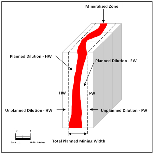
Note: Figure prepared by First Majestic, April 2025.
Mining loss of 5% has been assumed in the estimate. Mining loss refers to the proportion of mineralized material above the cut-off grade (COG) that is included within the mine designs but is not ultimately delivered to the plant for processing due to various operational constraints. This loss may result from operational factors such as underbreak caused by poor blasting practices and directly impacts the economics of the operation by reducing the volume of recoverable material and consequently, the
| 131 | September 2025 |
| La Encantada Silver Mine Coahuila, Mexico NI 43-101 Technical Report on Mineral Resource and Mineral Reserve Estimates |
|
potential revenue. Figure 15-2 and Figure 15-3 are schematic examples of dilution and mining loss in longhole and cut-and-fill mining.
Figure 15-2: Schematic Example of Dilution and Mining Loss in Longhole Mining
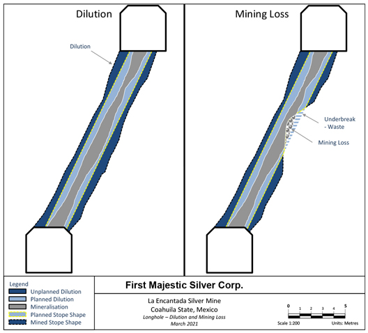
Note: Figure prepared by Entech Mining Consultants Ltd. for First Majestic, March 2021.
| 132 | September 2025 |
| La Encantada Silver Mine Coahuila, Mexico NI 43-101 Technical Report on Mineral Resource and Mineral Reserve Estimates |
|
Figure 15-3: Schematic Example of Dilution and Mining Loss in Cut & Fill Mining
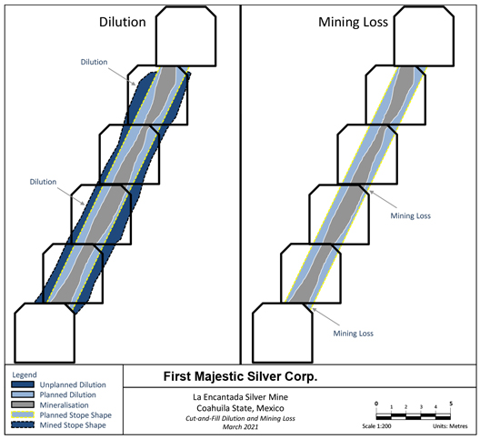
Note: Figure prepared by Entech Mining Consultants Ltd. for First Majestic, March 2021.
A sublevel caving mining method was selected to mine the Ojuelas deposit. Sublevel caving is a bulk mining method that inherently includes internal dilution within the caving extraction column design. Run-of-mine (ROM) material from Ojuelas is expected to include an estimated 14% internal dilution from waste material enclosed within the caving extraction columns as well as an estimated 5% unplanned dilution resulting from mucking and rehandling activities.
For the Vein System deposits, longhole stoping or cut-and-fill mining methods were selected across the various domains, depending on geometry and geotechnical conditions. For longhole stoping, a minimum mining width of 1.3 m was designed. This is based on a minimum vein width of 1.0 m, plus an allowance for 0.15 m on both the hanging wall and footwall. This 0.15 m of planned dilution is applied regardless of the vein width, to ensure that the mineable shapes include a reasonable amount of planned dilution. For cut-and-fill, a minimum mining width of 3.0 m was designed to accommodate jumbo drilling equipment. Where cut-and-fill is employed, the waste surrounding the vein will be slashed out to the width of the drift to provide a stable working floor for subsequent lifts and to ensure sufficient maneuverability for the jumbo. Table 15-5 shows an example calculation of planned and unplanned dilution for each mining method.
| 133 | September 2025 |
| La Encantada Silver Mine Coahuila, Mexico NI 43-101 Technical Report on Mineral Resource and Mineral Reserve Estimates |
|
Table 15-5: Example Calculation of Planned and Unplanned Dilution for Vein Systems
| Veins Systems |
Mining Dilution Parameters | |||||
| Parameters |
Longhole | Cut & Fill | Unit | |||
| Minimum Vein Width |
1.00 | 3.00 | meter | |||
| Planned Dilution—HW |
0.15 | 0.00 | meter | |||
| Planned Dilution—FW |
0.15 | 0.00 | meter | |||
| Total Planned Mining Width |
1.30 | 3.00 | meter | |||
| Planned Dilution—HW |
12 | 0% | ||||
| Planned Dilution—FW |
12 | 0% | ||||
| Total Planned Mining Width |
23 | 0% | ||||
| Unplanned Dilution |
||||||
| Unplanned Dilution—Mucking |
5 | 5% | ||||
| Unplanned Dilution—Rehandling |
3 | 3% | ||||
| Total Unplanned Dilution |
8 | 8% | ||||
| Total Dilution |
||||||
| Planned + Unplanned Dilution |
31 | 8% | ||||
| 15.5. | Potentially Mineable Shapes and Mine Design |
Deswik Stope Optimizer software was used to generate potentially mineable stope shapes based on Indicated Mineral Resources. The optimization process applied a range of design parameters, including orebody azimuth and dip, stope dimensions (length and height), minimum mining width, planned dilution, and the applicable cut-off grade. The selection of these parameters is conducted in consultation with the mine geotechnical team ensuring that geotechnical constraints are respected. Once defined, the parameters were configured within the Stope Optimizer to produce preliminary mineable stope shapes. Table 15-6 shows the modifying factors that are considered for each mining method.
Table 15-6: Parameters for Creation of Potentially Minable Stope Shapes
| Parameter |
Value | Unit | ||
| Crosscut Spacing, Ring Burden, Height—Caving Ojuelas |
12.5 x 2 x 22 | meter | ||
| Sublevel Spacing—Caving Ojuelas |
15 | meter | ||
| Minimum Mining Width—Longhole Stoping |
1.00 | meter | ||
| Minimum Mining Width—Cut & Fill |
3.00 | meter | ||
| Planned Dilution—HW / FW—Longhole Stoping |
0.30 | meter | ||
| Planned Dilution—HW / FW—Cut & Fill |
0.00 | meter |
The resulting stope shapes honour all defined constraints and include attributes required for economic evaluation, such as the resource classification, diluted silver grade and tonnage. The potentially minable stope shapes were visually reviewed and validated to confirm alignment with geological continuity, mining method geometry, and geotechnical stability criteria. Mine designs are then created to estimate the lateral and vertical development needed to access the potentially mineable stope shapes. An economic evaluation is then conducted to determine which areas or sublevels yield a positive cash flow. Only those areas or sublevels that generate a positive cash flow are used to create the LOM plan and included in the Mineral Reserve statement.
| 134 | September 2025 |
| La Encantada Silver Mine Coahuila, Mexico NI 43-101 Technical Report on Mineral Resource and Mineral Reserve Estimates |
|
| 15.6. | Mineral Reserves Estimate |
Mineral Reserves are reported using the 2014 CIM Definition Standards and have an effective date of December 31, 2024. The Qualified Person for the estimate is Mr. Andrew Pocock, P. Eng., a First Majestic employee. The Mineral Reserves estimate for La Encantada is provided in Table 15-7.
Table 15-7: La Encantada Mineral Reserves Statement (Effective Date December 31, 2024)
| Category / Area |
Mineral Type | Tonnage | Grades | Metal Content | ||||||||
| k tonnes | Ag (g/t) | Ag-Eq (g/t) | Ag (k Oz) | Ag-Eq (k Oz) | ||||||||
| Prieta Complex: Ojuelas |
Oxides | 1,106 | 154 | 154 | 5,469 | 5,469 | ||||||
| Milagros Breccia |
Oxides | 1,742 | 88 | 88 | 4,935 | 4,935 | ||||||
| Veins Systems |
Oxides | 540 | 258 | 258 | 4,479 | 4,479 | ||||||
| Total Probable |
Oxides | 3,388 | 137 | 137 | 14,883 | 14,883 | ||||||
| (1) | Mineral Reserves are classified per CIM Definition Standards (2014) and NI 43-101. |
| (2) | Mineral Reserves are effective December 31, 2024, are derived from Measured & Indicated Resources, account for depletion to that date, and are reported with a reference point of mined ore delivered to the plant. |
| (3) | Reserve estimates were supervised or reviewed by Andrew Pocock, P.Eng., Internal Qualified Person for First Majestic per NI 43-101 |
| (4) | Silver-equivalent grade (Ag-Eq) is silver grade and is included for consistency across all material properties. |
| (5) | Metal prices considered for Mineral Reserves estimates were $26.00/oz Ag. Other key assumptions and parameters include: metallurgical recoveries of 59% for Prieta Complex: Ojuelas, weighted average of 55% for Veins Systems and 70.8% for Milagros Breccia; costs ($/t): direct mining $44.4 cut & fill, $26.7 longhole stoping, $11.77 sub level caving, processing $20.69 mill feed, indirect/G&A $13.41, and sustaining of $6.47. |
| (6) | A two-step cutoff approach was used per mining method: A general cutoff grade defines mining areas covering all associated costs; and a 2nd pass incremental cutoff includes adjacent material covering only its own costs, excluding shared general development access & infrastructure costs which are covered by the general cutoff material. |
| (7) | Modifying factors for conversion of resources to reserves include but are not limited to consideration for mining methods, mining recovery, dilution, sterilization, depletion, cutoff grades, geotechnical conditions, metallurgical factors, infrastructure, operability, safety, environmental, regulatory, social, and legal factors. These factors were applied to produce mineable stope shapes. |
| (8) | Tonnage in thousands of tonnes, metal content in thousands of ounces, prices/costs in USD. Numbers are rounded per guidelines; totals may not sum due to rounding. |
| 15.7. | Factors that May Affect the Mineral Reserve Estimates |
Factors which may materially affect the Mineral Reserve estimates for the La Encantada mine include fluctuations in commodity prices and exchange rate assumptions used; material changes in the underground stability due to geotechnical conditions which could increase unplanned dilution and mining loss; unexpected variations in equipment productivity; material reduction in the capacity to process the mineralized material at the planned throughput and unexpected reduction of the metallurgical recoveries; higher than anticipated geological variability; cost escalation due to external economic factors; changes in the taxation considerations; the ability to maintain constant access to all working areas; changes to the assumed permitting and regulatory environment under which the mine plan was developed; the ability to maintain mining concessions and/or surface rights; the ability to renew agreements with the different surface owners in the La Encantada area; and the ability maintain the social and environmental licenses to operate.
| 135 | September 2025 |
| La Encantada Silver Mine Coahuila, Mexico NI 43-101 Technical Report on Mineral Resource and Mineral Reserve Estimates |
|
| 16. | MINING METHODS |
| 16.1. | Overview |
Beginning in 2007, First Majestic started producing from both the Prieta and San Javier–Milagros mining areas using cut-and-fill and room-and-pillar mining. In 2010, with the addition of the cyanide plant, the mine processed fresh material from underground and old tailings until 2014. From 2014 to 2018, the mine produced a mixture of material from the old Peñoles low-grade stockpiles, high-grade ore from veins, and recovery of backfill and pillar materials using a hybrid caving method. In 2018, First Majestic activated the San Javier sublevel caving mining to offset production from the Peñoles low-grade stockpiles. Production increased in 2019 with the start of the Prieta cave mining. In 2022 the La Encantada started development of the Ojuelas caving project achieving production in 2023.
| 16.2. | Mining Environment |
| 16.2.1. | Hydrogeological Considerations |
The La Encantada mine is in an arid region without surface water sources and scarce rainfall during the year. Therefore, the mine is dependent on groundwater for operations. Wells G5 and La Chata have supplied water for mining since before First Majestic’s ownership of the mine. G5 was redrilled in 2017 and the Pista well was drilled in 2018. In 2020, G5 and La Chata water supply declined, reaching critical levels impacting mine and plant operations in 2023. In 2024, two new wells were drilled, G-8 and G-11 which stabilized the water supply, enabling full operations. A 10-year water supply history is visible in Figure 16-1.
Figure 16-1: La Encantada 10 Year Water Supply History
Note: Well G8 had 1575 m3/month in 2024 and has not been producing in 2025.
Figure prepared by First Majestic, April 2025.
| 136 | September 2025 |
| La Encantada Silver Mine Coahuila, Mexico NI 43-101 Technical Report on Mineral Resource and Mineral Reserve Estimates |
|
Wells are monitored and tested periodically to ensure consistent supply and avoid overdrawing the aquifer. The main inflow of water comes from surface filtration during the rainy season, and water from drilling during mining operations.
| 16.2.2. | Geotechnical Considerations |
Geotechnical data is primarily collected through geotechnical core logging and underground mapping at La Encantada which is recorded in company databases. Geotechnical core logging is performed on diamond drill core after geological logging, using standard methods to collect parameters for Q (Barton et al., 1974), Rock Mass Rating (RMR) (Bieniawski, Z.T., 1989) or Geological Strength Index (GSI) (Hoek, et al., 1997) systems. Underground geotechnical mapping is conducted by a ground control engineer (or delegate) using scan line, window, and frontal mapping techniques. This aims to collect parameters for Q, RMR, or GSI classification.
Rock mass quality is evaluated by geotechnical domain, typically aligned with lithological boundaries using the GSI classification system, supplemented by estimates of elastic properties such as Young’s modulus and Poisson’s ratio. This methodology facilitates a structured understanding of prevailing ground conditions, enabling characterization of the rock mass as strong and brittle, weak and faulted, or highly jointed. Where hydrogeological factors are present and deemed relevant to stability, their influence is incorporated into the classification process. A summary of the principal geotechnical units is presented in Table 16-1.
Table 16-1 Rock Characteristics by Zone
| La Prieta | La Encantada | |||||||||||||||||||||||||||||||||||||||||||||||||||||||||||||||||||||||||||||||||||||||||||||||||||||||||||
| Domain_Name |
Litho- Limestone (HOST) |
Litho- Cuerpo 660 |
Litho- Cuerpo Asuncion |
Litho- Cuerpo Escondida |
Litho- Cuerpo Fallas 35 |
Litho- Cuerpo La Fe |
Litho- Cuerpo La Prieta |
Litho- Cuerpo Ojuelas |
Litho- Cuerpo San Francisco |
Litho- CAVE |
Litho- Skarn |
Faults | Lithology- Cuerpo_ EIMIL_ Orebody |
Lithol ogy-Cuerpo_ Nucleo_ Orebody |
Lithology- Cuerpo_ EISJ_ Orebody |
Lithology- Cuerpo_ Milagros_ Breccia_ Orebody |
Lithology- Cuerpo _San_Javier_ Brecc ia_Orebody |
Lithology- Cu erpo_ MIlagros_ Intrusive_ MIN_Orebody |
Lithology- Cuerpo_ MIlagros_ Intrusive_ Orebody |
Lithology- Veta_Dyke_ Bonanza_ Orebody |
Lithology- C uerpo_213_ Orebody |
Lithology- Cuerpo_274_ Orebody |
Lithology- Cuerpo_310_ Orebody |
Lithology- Cuerpo_Bonanza_ Orebody |
Lithology- Cuerpo_EIBZ_ Orebody |
Lithology - Ka (Limestone) |
Faults | |||||||||||||||||||||||||||||||||||||||||||||||||||||||||||||||||||||||||||||||||
| Density (t/m3) |
2.7 | 2.7 | 2.7 | 3 | 2.7 | 2.65 | 2.9 | 2.85 | 2.7 | 2.7 | 3 | 2.7 | 2.9 | 2.9 | 2.9 | 2.9 | 0 | 2.9 | 0 | 2.9 | 2.9 | 2.9 | 2.9 | 2.9 | 2.9 | 2.7 | 2.7 | |||||||||||||||||||||||||||||||||||||||||||||||||||||||||||||||||||||||||||||||||
| Ei (Mpa x 1000) |
40 | 12 | 12 | 15 | 12 | 12 | 12 | 12 | 12 | 16 | 40 | 16 | 12 | 12 | 12 | 12 | 12 | 15 | 15 | 12 | 12 | 12 | 12 | 12 | 12 | 40 | 16 | |||||||||||||||||||||||||||||||||||||||||||||||||||||||||||||||||||||||||||||||||
| GSI |
55 | 35 | 20 | 30 | 20 | 35 | 40 | 35 | 35 | 20 | 60 | 25 | 30 | 30 | 30 | 30 | 30 | 30 | 30 | 30 | 30 | 30 | 30 | 30 | 30 | 55 | 25 | |||||||||||||||||||||||||||||||||||||||||||||||||||||||||||||||||||||||||||||||||
| mi_max |
12 | 8 | 8 | 8 | 8 | 8 | 18 | 12 | 8 | 8 | 16 | 10 | 12 | 12 | 12 | 12 | 12 | 12 | 12 | 12 | 12 | 12 | 12 | 12 | 12 | 12 | 10 | |||||||||||||||||||||||||||||||||||||||||||||||||||||||||||||||||||||||||||||||||
| UCS (MPa) |
115 | 25 | 35 | 25 | 18 | 25 | 80 | 45 | 25 | 20 | 120 | 25 | 30 | 30 | 30 | 30 | 30 | 25 | 25 | 30 | 30 | 30 | 30 | 30 | 30 | 115 | 25 | |||||||||||||||||||||||||||||||||||||||||||||||||||||||||||||||||||||||||||||||||
| 137 | September 2025 |
| La Encantada Silver Mine Coahuila, Mexico NI 43-101 Technical Report on Mineral Resource and Mineral Reserve Estimates |
|
Site personnel conduct routine evaluations of underground stability, focusing on critical elements such as stope performance, crown pillar integrity, backfill behavior, and excavation dimensions. These assessments are integral to maintaining both the safety and efficiency of ongoing mining activities. A combined methodology is employed, incorporating empirical stability analysis and advanced numerical modeling. In particular, the Improved Unified Constitutive Model (IUCM) (Itasca Consulting Group, 2016), implemented via FLAC3D (Itasca Consulting Group, Inc., 2011), is utilized to capture the complex response of the rock mass under varying stress regimes. This robust analytical framework supports informed decision-making related to ground support design, mine sequencing, and overall geotechnical risk management.
Ground surface displacement related to caving-induced subsidence is systematically monitored using a combination of surface survey monuments, multi-point borehole extensometers (MPBX), and high-resolution aerial imagery acquired via drone surveys. These complementary monitoring methods provide continuous, spatially accurate data to detect and quantify ground movement over time.
To anticipate and manage the potential impacts of subsidence on key capital infrastructure, predictive modeling is conducted using the IUCM within the FLAC3D numerical modeling framework. This advanced approach allows for the simulation of rock mass behavior under evolving stress conditions, offering improved accuracy in forecasting surface and subsurface deformation. The integration of monitoring data with numerical simulations supports proactive risk management and the timely implementation of mitigation measures.
The ground support systems implemented at La Encantada incorporate a range of conventional support elements—including rock bolts, welded wire mesh, shotcrete, and cable bolts—applied in various configurations depending on local geotechnical conditions. Standardized ground support designs have been developed to address the diverse geological and structural settings encountered across the operation. These designs are consistently applied to ensure underground stability and worker safety, while remaining adaptable to site-specific requirements Figure 16-2 illustrates a representative ground support standard, detailing the typical layout and application for common excavation scenarios.
| 138 | September 2025 |
| La Encantada Silver Mine Coahuila, Mexico NI 43-101 Technical Report on Mineral Resource and Mineral Reserve Estimates |
|
Figure 16-2: Typical Ground Support Standard
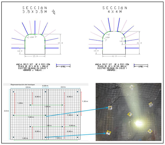
Note: Figure prepared by First Majestic, April 2025.
Risk assessment and hazard identification at La Encantada involve systematic evaluation of mining activities, locations, and systems to identify and manage potential geotechnical risks. The Ground Control Management Plan (GCMP) is reviewed and updated at least annually, or earlier if significant changes to mine design, mining methods, or equipment occur. Updates are performed by an authorized individual or designated team and are made available to relevant stakeholders upon request.
A defined two-way communication process is in place to ensure all personnel are informed of expected ground conditions, can recognize early warning signs, and can respond effectively to changing geotechnical conditions. Communication tools include inspection logs, daily and weekly meetings, geotechnical reports, and documented procedures.
Instances of non-conformance are identified, recorded, and managed through a formalized corrective action process. Each case is assigned clear responsibilities, deadlines, and remedial actions. The status of these actions is monitored and reviewed regularly, typically as part of monthly planning meetings. The rock mechanics supervisor maintains detailed records to ensure accountability and continuous improvement.
Ground conditions and support systems are monitored through regular inspections conducted by miners, supervisors, and technical personnel to ensure continued safety and effectiveness. Miners are responsible
| 139 | September 2025 |
| La Encantada Silver Mine Coahuila, Mexico NI 43-101 Technical Report on Mineral Resource and Mineral Reserve Estimates |
|
for performing daily workplace inspections, which are verified by supervisors, who also inspect development and production faces. Supervisors and technical staff jointly conduct weekly inspections of ramps and haul roads to identify any emerging geotechnical issues.
All identified ground control concerns, incidents, and corrective actions are documented in a centralized logbook and reflected on updated geotechnical plans. This facilitates efficient communication and reference during operational and planning meetings.
Over-excavation is systematically tracked, with a particular focus on reducing dilution—especially in areas utilizing long-hole stoping methods along narrow veins.
Data collected through the over-excavation monitoring program, along with leading indicators such as the extent of rehabilitation, shotcrete cracking, visible deformation, and fill dilution, are used to assess the performance and effectiveness of the GCMP. This feedback loop supports continuous improvement of ground control strategies.
| 16.3. | Mining Methods |
| 16.3.1. | Design Parameters |
First Majestics staff reviewed the geotechnical parameters, and a total of 13 geotechnical domains were created for the La Encantada mine. Using these domains, it is possible to design support guidelines for the underground mine’s different working areas. An example of some of the rock types can be seen in Figure 16-3.
| 140 | September 2025 |
| La Encantada Silver Mine Coahuila, Mexico NI 43-101 Technical Report on Mineral Resource and Mineral Reserve Estimates |
|
Figure 16-3: Example Geotechnical Domains for La Encantada
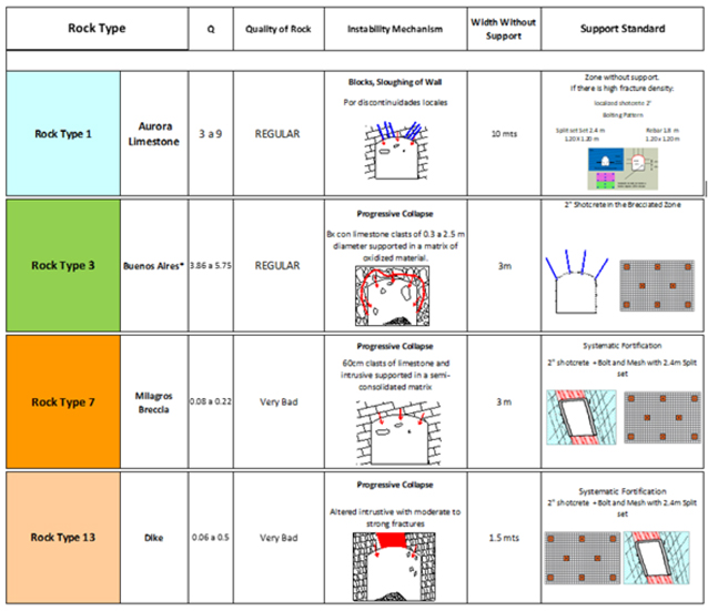
Note: Geotechnical domains are referred to as Rock Type 1-13. Figure prepared by First Majestic, April 2025.
Due to the different types of deposits and the related geotechnical characteristics, production is a mix of caving, longhole and cut-and-fill with the development-type widths and support standards shown in Table 16-2.
| 141 | September 2025 |
| La Encantada Silver Mine Coahuila, Mexico NI 43-101 Technical Report on Mineral Resource and Mineral Reserve Estimates |
|
Table 16-2: Development Types and Support Standards for La Encantada
| Development Type | Width (m) | Height (m) | Support | |||
| Ramps | 4 | 4.5 | Localized Support | |||
| Access | 3.5 | 3.5 | Localized Support | |||
| Footwall Drift | 3.5 | 3.5 | Localized Support | |||
| Drawpoint | 3.5 | 3.5 | Shotcrete and Bolting | |||
| Sublevel | 3 | 3.5 | Bolt and Mesh | |||
| Truck Loading bay | 4.5 | 4.5 | Localized Support | |||
| Ventilation Access | 3 | 3.5 | Localized Support | |||
| Conventional Raise | 1.8 | 1.8 | No Support | |||
| Robbins Raise | 1.8 | diam | No Support | |||
| Stock | 3.5 | 4 | Localized Support | |||
All development by caving into the mineralized breccia deposits has 4.0 x 4.0 m dimensions and is supported with a primary coat of 2” fibre shotcrete with bolts and mesh, followed by a secondary 2” coat of shotcrete to prevent unravelling of the weak rock matrix.
| 16.3.2. | Sublevel Caving |
Given the variable geometry of the deposit, sublevel caving has been selected to reduce dilution and improve recovery. Figure 16-4 presents a conceptual schematic model of the sublevel caving mining method.
| 142 | September 2025 |
| La Encantada Silver Mine Coahuila, Mexico NI 43-101 Technical Report on Mineral Resource and Mineral Reserve Estimates |
|
Figure 16-4: Sublevel Caving Schematic Model
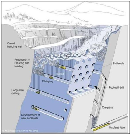
Note: Adapted from Atlas Copco Rock Drills AB, 2000. Figure prepared by Dassault Systèmes Geovia.
The diagram illustrates the primary infrastructure required, including haulage levels, ore passes, sublevels, and production drifts. The typical production cycle—longhole drilling, charging, blasting, and mucking—is depicted in sequence. Rock fragmentation and progressive cave propagation are also shown. Sublevel caving is currently being applied at the Ojuelas deposit.
| 16.3.3. | Longhole Stoping |
The steeply dipping veins at La Encantada range in width from 0.5 to 8.0 meters. Longhole stoping is applied in areas where the veins exhibit a near-vertical dip, consistent strike length, and are hosted in competent wall rock. The method supports the site’s bulk mining strategy and is prioritized wherever geological and geotechnical conditions allow.
For the current Mineral Reserves update, all veins within the Vein System, including the Veta Dique San Francisco deposit, were evaluated for longhole stoping. The evaluation focused on maximizing bulk extraction potential across the deposit. A minimum mining width of 1.0 meter was applied, with planned dilution of 0.15 meters incorporated on both the hanging wall and footwall sides through the Stope Optimizer.
| 143 | September 2025 |
| La Encantada Silver Mine Coahuila, Mexico NI 43-101 Technical Report on Mineral Resource and Mineral Reserve Estimates |
|
Stopes were designed using two standard height configurations, 20 meters and 10-15 meters, depending on the continuity and geometry of the vein in each zone. These configurations were applied across all longhole-evaluated veins to adapt to variations in geological confidence and structural conditions.
Many of the evaluated areas were historically mined and have significant preexisting development. Longhole stoping was applied to in situ zones that remain unmined and are accessible via existing infrastructure. In areas not yet reached by development, access design leveraged historical workings to propose optimal ramp and drift layouts.
The host rock is competent limestone with favorable geotechnical characteristics. Veins are accessed via footwall ramps, and development is extended through the economic zone and supported as required. Production holes are drilled along strike, with stope lengths governed by hydraulic radius calculations. Waste pillars are left in place where required to maintain stope stability. Figure 16-5 presents a schematic of the longhole stoping configuration.
Figure 16-5: Longhole Open Stoping Schematic Model
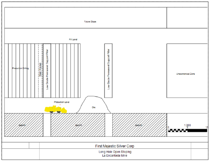
Note: Figure prepared by First Majestic, April 2025.
| 144 | September 2025 |
| La Encantada Silver Mine Coahuila, Mexico NI 43-101 Technical Report on Mineral Resource and Mineral Reserve Estimates |
|
After completing the extraction of a given level, the stope is subsequently backfilled, allowing the sequence to continue. This allows for higher production rates while maintaining a lower operating cost.
| 16.3.4. | Cut-and-Fill |
The Conejo vein is currently mined using a drift-and-fill variant of the cut-and-fill (CAF) method, carried out with mechanized jumbos. This method has been adopted due to the vein’s highly variable thickness across short distances, which makes it less suitable for bulk mining approaches in certain areas.
For the current Mineral Reserves update, the Conejo vein complex was evaluated for both CAF (jumbo) and longhole stoping methods. This dual evaluation was completed to provide operational flexibility and align with La Encantada’s bulk mining strategy wherever conditions permit. The selected mining method in each area is based on key variables such as vein thickness and the level of geological continuity and confidence. In zones where confidence in geometry and continuity is lower, CAF (jumbo) has been applied to ensure control and adaptability. In more continuous and better-defined areas, longhole stoping has been selected to allow for more efficient bulk extraction.
In the brecciated veins such as Regalo, 990, 990-2 and Buenos Aires, mechanized cut-and-fill is used due to poorer ground conditions and strong alteration in the hanging wall and footwall. This method utilizes a jumbo drill to perform horizontal drilling along the dip direction, followed by blasting in retreat. Once blasted, the broken material is mucked out, and then the access is pivoted. The drift is then backfilled with waste material to prepare for the subsequent cut. The ramp is developed in the footwall and the initial access drift is driven at -15% gradient. After extraction, the drift is then pivoted to +15% gradient to allow for maximum extraction from each access. Figure 16-6 illustrates the fundamental design of the cut-and-fill method.
| 145 | September 2025 |
| La Encantada Silver Mine Coahuila, Mexico NI 43-101 Technical Report on Mineral Resource and Mineral Reserve Estimates |
|
Figure 16-6: Cut-and-fill Mining Method Schematic Model
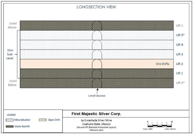
Note: Figure prepared by Entech Mining Consultants Ltd. for First Majestic, April 2021.
The minimum planned mining width for cut-and-fill is 3.0 meters, consistent with the standard drift width required for mechanized CAF mining using a jumbo drill. This width is incorporated into the design using the Stope Optimizer. Mining is carried out through horizontal development and is typically transferred to stock bays and subsequently loaded into 20-tonne rigid axle trucks for haulage to the surface stockpile.
| 16.4. | Mine Layout-Ojuelas |
In 2023, a trade-off study was conducted to evaluate the most practical mining method for the Ojuelas deposit. This marked a strategic transition point for the operation, as mining activity at the Prieta Complex, located within Mina La Prieta, was approaching depletion. The Ojuelas deposit, also located within Mina La Prieta, was identified as the next primary caving target to sustain bulk production. Historically mined using caving methods, the Prieta Complex had been a key production area.
The objective of the study was twofold: to compare inclined caving versus sublevel caving, and to validate the in-house SLC design initially developed. The study was conducted by the Block Caving Unit at Dassault Systèmes GEOVIA and incorporated inputs from the block model, geological model, rock mechanics parameters, and economic assumptions. The study concluded that sublevel caving was the most viable method for Ojuelas. This decision was supported by the operation’s existing experience with the method in the Prieta Complex and San Javier–Milagros orebodies, as well as the confirmation that the proposed
| 146 | September 2025 |
| La Encantada Silver Mine Coahuila, Mexico NI 43-101 Technical Report on Mineral Resource and Mineral Reserve Estimates |
|
15-meter-high sublevels were appropriate for the geotechnical conditions and orebody geometry. Dassault Systèmes GEOVIA also provided recommendations to further refine and improve the mine layout.
The Ojuelas deposit is currently mined using a sublevel caving (SLC) method, following the comprehensive design and validation process. As the geological model was refined, the mine design was updated accordingly. The current layout includes sublevels developed at 15-meter vertical intervals, from 1540m RL down to 1435m RL. Crosscuts are spaced at 12.5 meters between draw points, and drilling is performed with a ring height of 22 meters and a burden of 2 meters.
Cave initiation began at the 1525m RL level, and cave propagation is progressing through the hanging wall. Ore draw is executed using a structured draw strategy to manage cave propagation and control dilution. Draw point performance is monitored closely to ensure optimal recovery. Ground movement is tracked through extensometers and microseismic monitoring. The operation continues to monitor key performance indicators to optimize draw sequencing, minimize dilution, and maintain long-term production sustainability.
Figure 16-7 and Figure 16-8 show the elevations where the mineralized zone and hanging wall initiate self caving.
Figure 16-7: Plan View of Ojuelas 1480 Level Layout
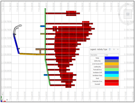
Note: Figure prepared by First Majestic, April 2025.
| 147 | September 2025 |
| La Encantada Silver Mine Coahuila, Mexico NI 43-101 Technical Report on Mineral Resource and Mineral Reserve Estimates |
|
Figure 16-8: Plan View of Ojuelas 1465 Level Layout
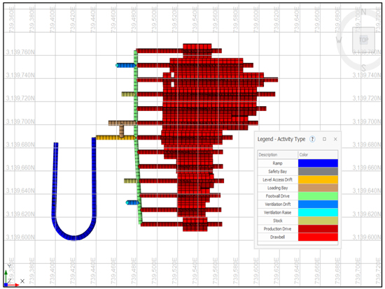
Note: Figure prepared by First Majestic, April 2025.
Figure 16-9 shows a cross section of the Ojuelas sublevel cave design and Figure 16-10 shows a long section of the Ojuelas cave design.
| 148 | September 2025 |
| La Encantada Silver Mine Coahuila, Mexico NI 43-101 Technical Report on Mineral Resource and Mineral Reserve Estimates |
|
Figure 16-9: Cross Section of the Ojuelas Sublevel Cave Design
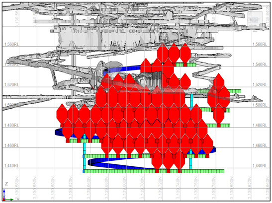
Note: Figure prepared by First Majestic, April 2025.
Figure 16-10: Long Section of the Ojuelas Sublevel Cave Design looking North
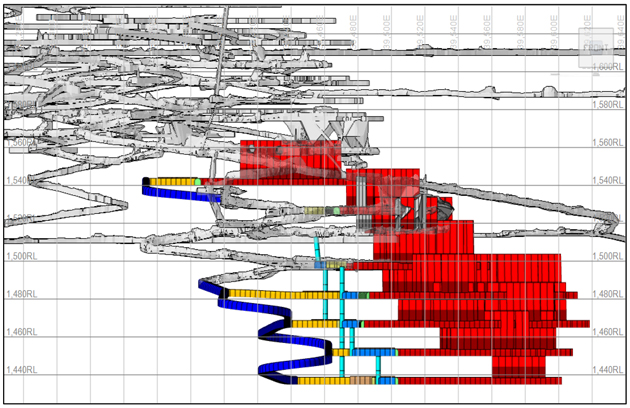
Note: Figure prepared by First Majestic, April 2025.
| 149 | September 2025 |
| La Encantada Silver Mine Coahuila, Mexico NI 43-101 Technical Report on Mineral Resource and Mineral Reserve Estimates |
|
The total mine design for Ojuelas includes 7.23 km of development over three years. Production began at the 1525m RL elevation, and production levels extend down to 1435m RL, with a total production of over 1 million tonnes over three years. Longhole drilling is performed using pneumatic drills and will require a total of three drill rigs.
All development in the mineralized zone is supported with two 2-inch coats of fiber- reinforced shotcrete, with a layer of rebar and mesh installed between each shotcrete application. Steel arches are installed at the contact between the skarn and the mineralized zone to reinforce the draw point access areas. During the development of ore drive crosscuts, challenges were encountered when crossing a wide fault zone. Geotechnical controls and support designs were adjusted to manage these conditions and ensure safe access to the mineralized areas.
Material is extracted from draw points using 3.5 yd3 LHD (scoops) and transported to truck loading bays located near each sublevel access. From there, the material is hauled to the surface stockpile in 20-tonne ridged axle trucks. Ventilation will be injected down the main ramp and exhausted out each footwall drift to a raise that will connect to historical workings. Individual draw-points will be ventilated with auxiliary fans.
| 16.5. | Mine Layout Vein-type Deposits |
The Vein systems deposits will be mined using a combination of cut-and-fill and longhole stoping methods. Longhole stoping will be applied the Veta Dique San Francisco deposit, due to the good continuity of mineralization along both dip and strike. Although the vein is highly altered and of poor geotechnical quality, it is contained by competent limestone. Vein widths in this area range from 1–8 meters. Using the Rock mass rating (RMR) assessments and numerical stress simulations have been used to evaluate the stability of open stopes under the expected ground conditions. An example of a stress cross-section for the Veta Dique San Francisco area can be seen in Figure 16-11.
| 150 | September 2025 |
| La Encantada Silver Mine Coahuila, Mexico NI 43-101 Technical Report on Mineral Resource and Mineral Reserve Estimates |
|
Figure 16-11: Section View of the simulated stresses for the Veta Dique San Francisco Stope, Looking North
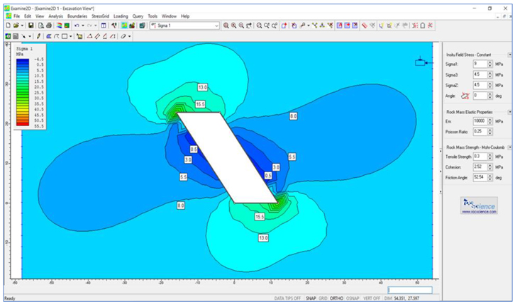
Note: Figure prepared by First Majestic, April 2025.
To determine stope stability in the Veta Dique San Francisco deposit, the critical hydraulic radius was calculated for the mineralized zone, hanging wall and footwall. The analysis indicated that both the hanging wall and footwall are stable, with only blast-related damage expected. However, the mineralized zone was assessed as geotechnically unstable. To provide additional support, all developments in the Veta Dique San Francisco deposit will be supported with a two 2-inch coat of fiber-reinforced shotcrete layer, followed by rebar and mesh, and then a second 2-inch layer of shotcrete. Longhole stoping will primarily use downhole drilling, except for the final stope, which will be recovered using uphole drilling. Low-grade pillars will be left in place where necessary to improve stope stability and reduce dilution. For dilution estimation, an additional 0.2 meters of overbreak was applied on the hanging and footwall in the Stope Optimizer design.
The Veta Dique San Francisco area benefits from significant existing development. Sublevel access is planned through a combination of auxiliary ramps and historical ramp infrastructure, minimizing the amount of development required to extract the Mineral Reserves. Ventilation and material movement are expected to make use of historical raises and ore passes. A cross section illustrating the planned development and stopes can be seen in Figure 16-12.
| 151 | September 2025 |
| La Encantada Silver Mine Coahuila, Mexico NI 43-101 Technical Report on Mineral Resource and Mineral Reserve Estimates |
|
Figure 16-12: Cross Section View of Mine Plan for the Veta Dique San Francisco Deposit
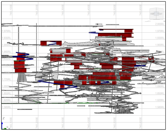
Note: Figure prepared by First Majestic, April 2025.
A total of 7.5 km of development is planned to prepare the longhole stopes. The mining sequence will begin at the lower elevations and progress upwards, allowing each stope to be backfilled before mining the level above. Unconsolidated development waste will be used as backfilled material for the longhole stopes.
| 16.6. | Dilution and Mining Loss |
For longhole stoping, the planned dilution has been incorporated into the stope designs for each orebody using the Stope Optimizer. Additional dilution assumptions, specific to each mining method, are applied as discussed in Section 15.4.
Mining recovery factors have been applied based on historical performance and expected efficiency of each mining method. For sublevel caving, mining recovery is influenced by draw point spacing, cave propagation behavior, and dilution control strategies. Recovery assumptions were based on guidance from the Dassault Systèmes GEOVIA Block Caving Unit, who provided a typical range of expected recovery values informed by their experience evaluating similar deposits. These assumptions will be further refined as the Ojuelas operation progresses and reconciliation data becomes available.
| 152 | September 2025 |
| La Encantada Silver Mine Coahuila, Mexico NI 43-101 Technical Report on Mineral Resource and Mineral Reserve Estimates |
|
| 16.7. | Development and Production Schedule |
Time in motion studies were conducted to establish a baseline for scheduling and equipment selection. Table 16-3 summarizes the projected development schedule.
Table 16-3: Development Schedule for La Encantada
| Type |
Size (m) | 2025 | 2026 | 2027 | Total | |||||||||||||||
| Main Access Ramp |
4.0 x 4.5 | 2,142 | 1,886 | 1,284 | 5,312 | |||||||||||||||
| Main Level Access |
4.0 x 4.0 | 678 | 597 | 407 | 1,683 | |||||||||||||||
| Ancillary |
4.0 x 4.0 | 3,668 | 3,230 | 2,199 | 9,097 | |||||||||||||||
| Ventilation Raises |
2.5 diam | 119 | 104 | 71 | 294 | |||||||||||||||
|
|
|
|
|
|
|
|
|
|||||||||||||
| Total Waste Development |
6,607 | 5,817 | 3,961 | 16,385 | ||||||||||||||||
|
|
|
|
|
|
|
|
|
|||||||||||||
| Ore Development |
4.0 x 4.0 | 2,297 | 1,621 | 1,414 | 5,332 | |||||||||||||||
|
|
|
|
|
|
|
|
|
|||||||||||||
| Total Development |
8,904 | 7,438 | 5,375 | 21,717 | ||||||||||||||||
|
|
|
|
|
|
|
|
|
|||||||||||||
The mine plan assumes an advance rate of 24 meters per day in 2025, decreasing to 20 meters per day in 2026, and 15 meters per day in 2027. Currently, two DD210 and two DD311 jumbos are utilized for horizontal development and ground support activities. A third jumbo is available on standby and is expected to provide sufficient capacity to meet annual development targets. Bolting operations are conducted using one DS311 and one Cannon bolter. The mobile equipment fleet includes 14 LH307 loaders and one LH410 loader, supporting mucking and material movement in both development and production areas. Longhole drilling is performed using one Stope Mate, one Cmac, and one DL2710 drill rig. Haulage is supported by two EJC 417 and two TH 315 trucks, while two Carmix mixers and two LS400 shotcrete sprayers are used for concrete batching and to support shotcreting.
| 16.7.1. | Vertical Development |
Vertical ventilation raises are excavated either by conventional jackleg drill-and-blast methods or using a raise-bore machine, with a typical diameter of 2.5 meters. Slot raises for both longhole stoping and sublevel caving will be developed using production drill rigs.
| 16.7.2. | Longhole Drilling |
Longhole drilling productivity varies between vein systems and sublevel caving areas. In the vein zones, where ground conditions are more competent, longhole drills achieve an average of 70–100 meters per shift. The caving zones present highly fractured ground, requiring every hole to be cased to prevent squeezing or collapse. As a result, drilling advance in these areas averages approximately 50 meters per shift.
The current fleet of loaders and haul trucks move an average of 4,000 tpd of run-of-mine (ROM) material and 1,000 tpd of waste. Haulage is conducted using a combination of owner-operated and contractor-supplied trucks. The in-house fleet consists of four units, two EJC 417 and two TH 315 trucks, while
| 153 | September 2025 |
| La Encantada Silver Mine Coahuila, Mexico NI 43-101 Technical Report on Mineral Resource and Mineral Reserve Estimates |
|
additional haulage capacity is provided by two contractor partners currently supplying a combined fleet of nine trucks. This arrangement ensures sufficient capacity to meet the haulage requirements of sublevel caving operations as well as vein system areas.
Table 16-4: Equipment Types
| Equipment Type |
Model | Quantity | ||||||
| LHD |
LH 203 | 4 | ||||||
| LHD |
LH 307 | 14 | ||||||
| LHD |
LH 410 | 1 | ||||||
| Haul Truck |
TH 417 | 2 | ||||||
| Haul Truck |
TH 315 | 2 | ||||||
| 16.7.3. | Life of Mine Production Schedule |
The projected LOM production schedule, including annual material movement of ore and waste is presented in Figure 16-13.
Figure 16-13: Mine Production Material Movement
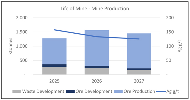
Note: Figure prepared by First Majestic, April 2025.
| 154 | September 2025 |
| La Encantada Silver Mine Coahuila, Mexico NI 43-101 Technical Report on Mineral Resource and Mineral Reserve Estimates |
|
Table 16-5 shows the LOM production schedule plan.
| 155 | September 2025 |
| La Encantada Silver Mine Coahuila, Mexico NI 43-101 Technical Report on Mineral Resource and Mineral Reserve Estimates |
|
Table 16-5: Production Schedule
| Life of Mine - La Encantada |
Unit | TOTAL | 2025 | 2026 | 2027 | |||||||||||||||
| La Prieta |
Tonnes Ore | kt | 1,126 | 384 | 380 | 362 | ||||||||||||||
| Grade Ag | g/t | 154 | 143 | 164 | 157 | |||||||||||||||
| Ounces Ag Mined | koz | 5,586 | 1,760 | 2,001 | 1,824 | |||||||||||||||
| Met. Recovery Ag | % | 59 | % | 59 | % | 59 | % | 59 | % | |||||||||||
| Ounces Ag Recovered | koz | 3,293 | 1,038 | 1,180 | 1,075 | |||||||||||||||
| La Encantada |
Tonnes Ore | kt | 2,280 | 531 | 882 | 869 | ||||||||||||||
| Grade Ag | g/t | 128 | 168 | 120 | 112 | |||||||||||||||
| Ounces Ag Mined | koz | 9,417 | 2,871 | 3,407 | 3,139 | |||||||||||||||
| Met. Recovery Ag | % | 67 | % | 62 | % | 67 | % | 68 | % | |||||||||||
| Ounces Ag Recovered | koz | 6,209 | 1,787 | 2,280 | 2,142 | |||||||||||||||
| MLAP + MLAE |
Tonnes Ore | kt | 3,406 | 915 | 1,262 | 1,231 | ||||||||||||||
| Grade Ag | g/t | 137 | 157 | 133 | 125 | |||||||||||||||
| Ounces Ag Mined | koz | 15,003 | 4,631 | 5,409 | 4,963 | |||||||||||||||
| Met. Recovery Ag | % | 63 | % | 61 | % | 64 | % | 65 | % | |||||||||||
| Ounces Ag Recovered | koz | 9,502 | 2,825 | 3,460 | 3,217 | |||||||||||||||
| 16.8. | Mine Services |
| 16.8.1. | Ore and Waste Handling |
Ore is mucked from stopes, caving draw points, or development headings to the nearest remuck bay, where it is loaded into either an underground mine truck or a contractor supplied 20 tonne rigid axle haul truck at a designated truck loadout station. Waste used for backfill is transported to empty stopes, while excess waste is hauled to the surface storage facility. Mineralized material is hauled to the surface via a ramp system. High grade ore is stockpiled at the San Francisco stockpile, while medium to low grade ore is placed at the Cañadas stockpile. A front-end loader then loads a 40-tonne articulated trucks with blended material from both stockpiles to meet the processing plant’s monthly planned feed grade.
| 16.8.2. | Ventilation |
The La Encantada mine is separated into two working areas: the Prieta complex mine with a 400hp main fan and the La Encantada mine with a 350hp main fan.
The main circuit of La Prieta mine has a total extraction capacity at the Maria Isabel shaft of 195,105 cfm which is regulated down to 113,000 cfm to meet mine requirements. Air intake is via the mine portal and the 660 raise. Figure 16-14 shows the ventilation circuit for the Prieta complex mine.
| 156 | September 2025 |
| La Encantada Silver Mine Coahuila, Mexico NI 43-101 Technical Report on Mineral Resource and Mineral Reserve Estimates |
|
Figure 16-14: Ventilation Circuit for Prieta Complex Mine Area
Note: Figure prepared by First Majestic, April 2025.
In the La Encantada mine area, a total of 145,000 cfm is used for the ventilation of the working areas with a booster fan in the La Joroba raise which adds 66,500 cfm. Fresh air enters via the El Plomo area and Guadalupe mine portal and is exhausted through the main vent raise. Figure 16-15 shows the ventilation circuit for the La Encantada mine area.
Figure 16-15: Ventilation Circuit for La Encantada Mine Area
Note: Figure prepared by First Majestic, April 2025.
| 157 | September 2025 |
| La Encantada Silver Mine Coahuila, Mexico NI 43-101 Technical Report on Mineral Resource and Mineral Reserve Estimates |
|
| 16.8.3. | Mine Dewatering |
La Encantada mine is a dry mine with the only inflow of water being surface filtration during the rainy season and from water used for mining activities. The mine has one dewatering pump located in the Prieta mine area at the 1509 elevation with a capacity of 4.5 gallons per minute. This pumps water up the Maria Isabel shaft which fills the water tanks located at the Guadalupe portal. This water is used in the mining process.
| 16.8.4. | Compressed Air and Services Water |
Mine compressed air is supplied by two Ingersoll Rand surface compressors, with 400 HP and 500 HP motors each, which supply 4,600 cfm at a pressure of 120 psi. Three reservoirs on surface store the compressed air. Compressed air is supplied to the mine through an 8” pipeline from surface to the 1790 level. From a secondary reservoir on the 1790 level, the air is supplied to the working areas in the Milagros mine. A secondary 6” pipeline goes down the Maria Isabel shaft to the 1600 working area in the Prieta mine to be supplied to the working areas.
Water is supplied to the San Javier-Milagros mine by a 10,000 L tank located above the Guadalupe portal. A larger tank of 230,000 L, located behind the mine offices, supplies water to the Prieta mine. The water for the mine is supplied by the dewatering pump located at the 1509 elevation.
| 16.9. | Equipment and Manpower Requirements |
| 16.9.1. | Manpower |
The La Encantada mine contains a camp where both contractors and company employees live during their rotation. The mine maintains a rotation of 14-days in, seven-days out with an eleven-hour work shift.
The current staff on site is sufficient for the planned development and production.
| 16.9.2. | Equipment |
Jumbos are used in the Ojuelas area, and for development at Veta Dique San Francisco, while jacklegs are used for the development of the veins that will be mined using cut-and-fill. The current development and loader fleet is sufficient to meet development and extraction targets of the LOM plan. Additional haul trucks will need to be contracted as the caving extraction increases in 2022. The mine site currently has two longhole rigs on site. Four drill rigs will be required for the mine production, one in the Veta Dique San Francisco longhole and three will be in Ojuelas. Table 16-6 shows the equipment needed during the LOM plan.
| 158 | September 2025 |
| La Encantada Silver Mine Coahuila, Mexico NI 43-101 Technical Report on Mineral Resource and Mineral Reserve Estimates |
|
Table 16-6: Required Equipment for the LOM plan.
| Equipment Type |
Model | Quantity | ||||
| Loader |
LH 307 | 14 | ||||
| Loader |
LH 410 | 1 | ||||
| Jumbos |
DD 210 | 2 | ||||
| Jumbos |
DD 311 | 2 | ||||
| Bolter |
DS 311 | 1 | ||||
| Bolter |
Cannon | 1 | ||||
| Long Hole Rig |
Stope Mate | 1 | ||||
| Long Hole Rig |
Cmac | 1 | ||||
| Long Hole Rig |
DL2710 | 1 | ||||
| Haul Trucks |
EJC 417 | 2 | ||||
| Haul Trucks |
TH 315 | 2 | ||||
| Carmix |
ONE | 2 | ||||
| Shotcrete Sprayer |
LS 400 | 2 | ||||
| 16.9.3. | Mine Contractors |
The mine site employs contractors for haulage, projects, mine development, core drilling, site security, food preparation, and environmental. The current onsite contractors are not expected to increase for the production schedule planned.
| 159 | September 2025 |
| La Encantada Silver Mine Coahuila, Mexico NI 43-101 Technical Report on Mineral Resource and Mineral Reserve Estimates |
|
17. RECOVERY METHODS
| 17.1. | Introduction |
The La Encantada processing plant, which has operated for many years, utilizes cyanide tank leaching followed by Merrill-Crowe processing to recover silver from ground run-of-mine (ROM) ore, producing silver doré bars. The plant is designed with a crushing and grinding capacity of 3,400 tonnes per day (tpd) and a leaching circuit capacity of 4,500 tpd. The facility is divided into two sections: Plant No. 1, which houses the crushing and grinding circuits, and Plant No. 2, which includes the leaching and recovery circuits.
Plant No. 1 features a three-stage crushing system with a primary jaw crusher, secondary and tertiary crushers in closed circuit with vibrating screens, and a grinding area with three ball mills operating in closed circuit with hydrocyclones. Plant No. 2 includes seventeen agitated cyanide leach tanks, a four-stage counter-current decantation (CCD) system, a Merrill-Crowe circuit with precipitate handling and smelting, and a tailings management system with three press filters and associated conveyors.
Additionally, a roasting circuit is installed and in care and maintenance, consisting of a dryer/pre-heater, rotary kiln, cooler, and a pulverized coal injection plant.
| 17.2. | Process Flowsheet |
Figure 17-1 illustrates the comminution and grinding flowsheet, while Figure 17-2 details the downstream processing flowsheet, beginning with the cyclone overflow from the ball mill circuit and continuing through to doré bar production and tailings management.
| 160 | September 2025 |
| La Encantada Silver Mine Coahuila, Mexico NI 43-101 Technical Report on Mineral Resource and Mineral Reserve Estimates |
|
Figure 17-1: La Encantada Schematic Comminution Plant Flowsheet, Plant No. 1
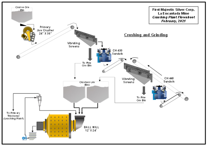
Note: Figure prepared by First Majestic, April 2025.
| 161 | September 2025 |
| La Encantada Silver Mine Coahuila, Mexico NI 43-101 Technical Report on Mineral Resource and Mineral Reserve Estimates |
|
Figure 17-2: La Encantada Processing Plant Flowsheet
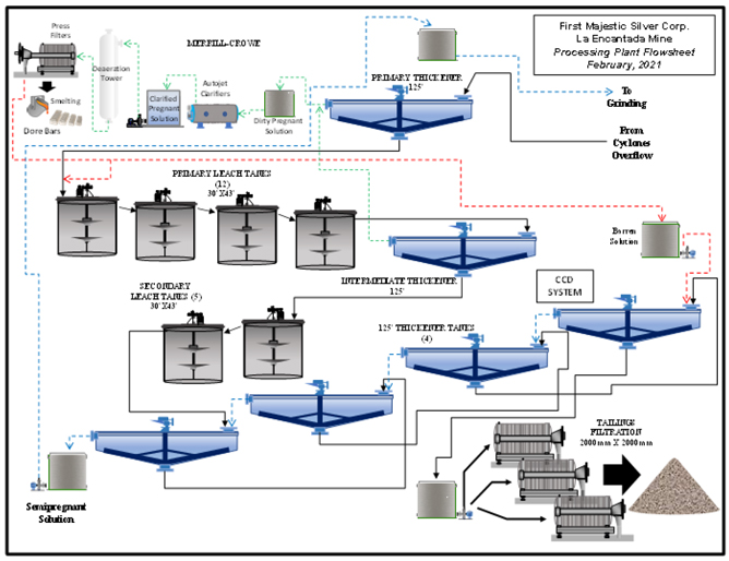
Note: Figure prepared by First Majestic, April 2025.
| 17.3. | Process Plant Configuration |
| 17.3.1. | Plant Feed |
Run-of-mine (ROM) material from the underground mine is delivered to a 300-tonne capacity steel coarse ore bin, which is topped with a steel rail grizzly featuring 12” x 12” openings. Oversized material retained on the grizzly is broken down using a hydraulic hammer. At the bottom of the bin, a vibrating grizzly feeder with 4” openings regulates the feed to the crushing circuit.
| 17.3.2. | Crushing |
Oversized material from the grizzly screen (–12” to +4”) is fed into a 24” x 36” primary jaw crusher, where it is reduced to a product size of approximately –3” to –31⁄2”. This product is then combined with the grizzly
| 162 | September 2025 |
| La Encantada Silver Mine Coahuila, Mexico NI 43-101 Technical Report on Mineral Resource and Mineral Reserve Estimates |
|
undersize and transported via a 30” wide belt conveyor to two single-deck primary vibrating screens with 3⁄8” x 3⁄8” apertures. The screen undersize, containing 80–90% passing 1⁄4”, is conveyed to a 3,000-tonne capacity steel fine-ore bin. The oversize is directed to a Sandvik CH430 secondary crusher, which reduces the material to –1” before discharging it onto a 30” wide conveyor. The fine-ore feed, averaging 3–4% moisture, also contains 80–90% passing 1⁄4”. The crushing plant operates 18 hours per day with a total capacity of 3,400 tpd.
| 17.3.3. | Grinding |
The grinding circuit is centered around a 12’ diameter x 24’ effective grinding length Metso ball mill powered by an 1,800 HP motor with a variable frequency drive. Fine ore is delivered via three chutes to a 36” wide conveyor equipped with a Ramsey cell to monitor feed tonnage to the mill. Grinding media consists of three ball sizes—21⁄2”, 2”, and 11⁄2”—to optimize grinding efficiency. The circuit includes a D-26” Krebs cyclone classification system and two 10” x 8” pumps rated at 250 HP, with one operating and the other on standby. Typical solids content through the circuit is 78% at mill discharge, 81% at the coarse ore cyclone, and 35% at the fine ore cyclone. The final grind achieves approximately 75% passing 200 mesh (P80 ~90 µm). The ground slurry is pumped to Plant No. 2 using an 8” x 6” 200 HP pump and fed into the primary thickener. Additionally, two ball mills are available and can be brought online as required to support operational flexibility or increased throughput. The nominal capacity of the grinding section is 3,400 tpd.
| 17.3.4. | Sampling |
An automatic dry-sample cutter is installed on the conveyor belt feeding fine ore to the grinding circuit, collecting samples every 15 minutes. These are composited into two-hour intervals for analysis. In addition, slurry samples are collected at multiple points throughout the circuit. All samples are prepared and assayed at the La Encantada Laboratory. This data is used to perform a daily metallurgical balance, providing silver grades and metal content for plant feed, tailings, and both pregnant and barren solutions.
Manual sampling is performed at key points in the process to monitor performance and ensure metallurgical control. These points include:
| • | Cyclone overflow; |
| • | Grinding products; |
| • | Pregnant leach solution (PLS); |
| • | Barren solution; |
| • | Final tailings (filter-press cake); |
| • | Each individual leach tank; and, |
| • | Solution recovered from the tailings filtering system and recirculated to the plant. |
| 163 | September 2025 |
| La Encantada Silver Mine Coahuila, Mexico NI 43-101 Technical Report on Mineral Resource and Mineral Reserve Estimates |
|
| 17.3.5. | Cyanide Leaching Circuit |
The following reagents are introduced into the process: cyanide, added as briquettes in leach tanks #1 and #6; and lime, prepared as a slurry in a stirred tank and added at the primary thickener. Cyclone overflow from the grinding circuit is pumped to Plant No. 2 and directed to a 125’ diameter primary thickener. The thickener underflow is transferred to twelve 30’ x 43’ agitated leach tanks, providing a 50-hour retention time for the first leaching stage. The overflow from the 12th leach tank feeds an intermediate thickener, which separates the pregnant solution (sent to the Merrill-Crowe system) and underflow, which is pumped into a second leaching stage comprising five additional 30’ x 43’ agitated tanks for a further 22 hours of leaching. A significant portion of the intermediate thickener’s overflow is recycled to the primary thickener to maintain silver recovery efficiency. The slurry from the final leach tank advances to a four-stage counter-current decantation (CCD) circuit using four 125’ thickeners in series. The underflow from the last CCD thickener feeds a storage tank that meters the slurry to three tailings pressure filters. The CCD overflow, containing residual cyanide and dissolved silver, is returned to the grinding circuit in Plant No. 1 for reagent and water reuse.
| 17.3.6. | Counter Current Decantation System |
Slurry from the final agitated leach tank is directed to a counter-current decantation (CCD) circuit composed of four 125’ diameter thickeners operating in series. The underflow from CCD thickener #4 is transferred to a final tailings storage tank before being fed to the press filters. The overflow from thickener #4 is recycled to the feed of thickener #3, where it mixes with the underflow from thickener #2; this stage also receives barren solution recovered from the press filters.
Overflow from thickener #2 is similarly routed to the feed of thickener #1, combining with the slurry from the final leach tank, while underflow from thickener #1 is sent forward to thickener #2. The overflow from thickener #1, now enriched with dissolved silver, flows to the pregnant solution pond, where it is combined with overflow solutions from the intermediate and primary thickeners prior to entering the Merrill-Crowe circuit.
| 17.3.7. | Merrill Crowe and Precipitate Handling |
The Pregnant Leach Solution (PLS) is first directed to a 1,200 m³ storage tank before undergoing filtration and clarification through three Autojet pressure clarifiers. The clean, clarified PLS is then stored in a separate 1,200 m³ tank before being pumped through two deaerator cylinders to remove dissolved oxygen.
Following deaeration, the PLS is transferred to three 1,500 mm press-filters, with zinc dust added prior to pumping to initiate the precipitation reaction. The daily production of PLS is approximately 18,000 m³, with an average grade of 17 g/t Ag.
| 164 | September 2025 |
| La Encantada Silver Mine Coahuila, Mexico NI 43-101 Technical Report on Mineral Resource and Mineral Reserve Estimates |
|
The resulting precipitate is dried and smelted in two induction furnaces, producing 23-kg doré bars with a silver purity range of 60–85%. The Merrill-Crowe system is capable of processing up to 550 kg of doré per day.
| 17.3.8. | Roasting Circuit |
In 2018, a roasting circuit was installed at Plant No. 2 to support the reprocessing of refractory tailings material through thermal treatment. During industrial-scale testing, a number of operational challenges were encountered, particularly related to material handling at the feed and product discharge points, inadequate cooling of the calcined product, and deficiencies in dust collection and control systems. The facility is currently in care and maintenance.
The rotary kiln roasting circuit is designed to enhance silver recovery by enabling the re-leaching of refractory tailings. Under operational conditions, the circuit would maintain a reducing atmosphere with a target bed temperature of approximately 850 degrees Celsius. These thermal and chemical conditions are intended to facilitate the breakdown of refractory minerals and produce a porous calcine product with improved leachability. Bench and pilot-scale tests indicated that this treatment would result in significantly higher silver extraction rates.
Tailings material would be loaded and hauled from the storage area to the roaster feed zone. A coarse dry screening unit is envisioned to be installed upstream of the feed belt to remove oversized particles and deleterious materials that may impact process stability. The undersize fraction would report to the feed conveyor, where chemical reagents, including sodium sulfite (Na₂SO₃) and sodium chloride (NaCl), would be applied to the material.
Material from the feed belt would be transferred via a bucket elevator to a screw conveyor and then introduced into the preheater. In the preheater, water would be sprayed onto the material, and heated air—recirculated from the cooler—would be introduced to initiate thermal conditioning. Preheated material would then be fed into the rotary kiln, where it would be further heated to the target temperature and held under reducing conditions to achieve calcination.
Following roasting, the calcine product would be transferred to a cooling system designed to reduce the material temperature to below 100 degrees Celsius. During earlier test campaigns, this cooling system did not perform as intended, and upgrades would be required before the system could be operated commercially. The cooled calcine would be slurried and pumped to the existing leach circuit. However, the roasting process generates agglomerates that can resist breakdown during slurrying. For this reason, the inclusion of a mechanical deagglomeration step is recommended in the final process flowsheet.
The primary fuel source for the roaster is mineral coal. Coal would be delivered to site, crushed, pulverized, and stored in a metering system prior to injection into the kiln burner. Dust and hot gases generated at various stages of the process, including the cooler and preheater, would be directed to a dust collection system. Collected dust would be reintroduced into the process stream, and cleaned
| 165 | September 2025 |
| La Encantada Silver Mine Coahuila, Mexico NI 43-101 Technical Report on Mineral Resource and Mineral Reserve Estimates |
|
exhaust gases would be vented to the atmosphere. Further improvements to dust control infrastructure are anticipated to mitigate environmental risk and meet applicable air quality standards.
Figure 17-3: Aerial View of the Roaster Circuit
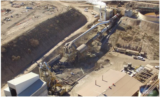
Note: Image taken by First Majestic, 2019.
| 166 | September 2025 |
| La Encantada Silver Mine Coahuila, Mexico NI 43-101 Technical Report on Mineral Resource and Mineral Reserve Estimates |
|
Figure 17-4: 3D-Model of Proposed Improvements for the Roaster Circuit

Note: Image prepared by Hatch for First Majestic, December 2020.
| 17.4. | Processing Plant Requirements |
The key requirements essential to the operation of the processing plant, as outlined in the LOM plan presented in this Technical Report, have been estimated. The projected consumption for these resources is summarized in
| 167 | September 2025 |
| La Encantada Silver Mine Coahuila, Mexico NI 43-101 Technical Report on Mineral Resource and Mineral Reserve Estimates |
|
Table 17-1 and includes the following consumables: electrical energy, fresh water, grinding media, cyanide, lime, flocculant, and zinc dust. All of these consumables are regularly supplied to the La Encantada mine, with existing purchase agreements in place as of the report’s effective date to support the production plan.
| 168 | September 2025 |
| La Encantada Silver Mine Coahuila, Mexico NI 43-101 Technical Report on Mineral Resource and Mineral Reserve Estimates |
|
Table 17-1: Processing Plant Requirements for the LOM Plan
| La Encantada Processing Plant | Consumption per year |
|||||||||||||
|
Consumables KPI Units |
2021 | 2022 | 2023 | 2024 | ||||||||||
| Power Consumption | 39 | kWh/t | MWh/yr | 11,481 | 21,381 | 19,082 | 5,977 | |||||||
|
Water consumption (fresh water usage) |
0.22 | m3/t | ‘000 m3/yr | 64.8 | 120.6 | 107.6 | 33.7 | |||||||
| Cyanide | 1.3 | Kg/t | t/yr | 383 | 713 | 636 | 199 | |||||||
|
Griding media (steel balls) |
0.17 | Kg/t | t/yr | 50 | 93.2 | 83.2 | 26.1 | |||||||
| Lime | 1.85 | Kg/t | t/yr | 545 | 1,014 | 905 | 284 | |||||||
| Flocculant | 35 | g/t | t/yr | 10.3 | 19.2 | 17.1 | 5.4 | |||||||
| Zinc dust | 1 | kg Zn/Kg Ag | t/yr | 45.5 | 64.2 | 53.2 | 16.2 | |||||||
| 169 | September 2025 |
| La Encantada Silver Mine Coahuila, Mexico NI 43-101 Technical Report on Mineral Resource and Mineral Reserve Estimates |
|
| 18. | INFRASTRUCTURE |
The existing infrastructure at La Encantada can support current mining and mineral processing activities and the LOM plan.
| 18.1. | Local Infrastructure |
Most of the operation’s support facilities are located near Plant No. 1 and include administrative offices, a medical clinic, warehouse, assay laboratory, core shed, fuel storage facilities, mine compressor building, surface maintenance shop, mine dry, water storage tanks and contractor offices. The mine camp is located approximately 1 km west of Plant No. 1 and the First Majestic-owned airstrip is approximately 6 km west of the mine camp.
Plant No. 2 is located 2 km northwest of Plant No. 1 and holds the leaching and roasting processing facilities, including the tailings filter-press plant. The Filtered Tailings Storage Facilities (FTSF) are located south and southwest of the Plant No. 2. The liquified natural gas (LNG) power generation plant is adjacent to Plant No. 2. Figure 18-1 shows the local infrastructure layout.
| 170 | September 2025 |
| La Encantada Silver Mine Coahuila, Mexico NI 43-101 Technical Report on Mineral Resource and Mineral Reserve Estimates |
|
Figure 18-1: Aerial Photo Showing Local Infrastructure at La Encantada
Note: Figure prepared by First Majestic, April 2025.
| 18.2. | Transportation and Logistics |
Operations personnel are transported by passenger buses from the city of Muzquiz and the town of Ocampo. All equipment, supplies and materials are brought in by road.
| 18.3. | Waste Rock Storage Facilities |
The Waste Rock Storage Facilities (WRSF) consists of eight different storage locations. Waste Rock Storage Facilities No. 1 to 6 are active and located south, the Waste Rock Storage Facility No. 7 is inactive and located north, and Waste Rock Storage Facility No. 8 is active and located between the other locations. Figure 18-2 shows the location of the WRSF No. 1 to 8
| 171 | September 2025 |
| La Encantada Silver Mine Coahuila, Mexico NI 43-101 Technical Report on Mineral Resource and Mineral Reserve Estimates |
|
Figure 18-2: Waste Rock Storage Facilities
Note: Figure prepared by First Majestic, April 2025.
| 18.4. | Filtered Tailings Storage Facilities |
The FTSF consists of two different storage areas. Filtered Tailings Storage Facility No. 5 (FTSF-5) which is currently in operation and Filtered Tailings Storage Facility No.4 (FTSF-4) which is inactive. Figure 18-3 shows the location of the FTSF-5 and FTSF-4.
The embankment construction of FTSF-5 follows an ascending terracing design with a standardized filtered tailings compaction method. Filtered tailings are transported by an overland belt conveyor system to the facility´s principal platform and deposited either with a series of radial stackers to spread over the crest with track dozers or with articulated trucks, then compacted and graded for erosion control and slope stability in the buttressing platform.
Rainwater management includes two main diversion channels, one located east of the FTSF parallel to the road, draining from south to north, and the second west, draining from north to south. In addition, the leveling of the front platform north of the facility diverts water towards the northeast contact water pond.
| 172 | September 2025 |
| La Encantada Silver Mine Coahuila, Mexico NI 43-101 Technical Report on Mineral Resource and Mineral Reserve Estimates |
|
The current storage capacity of the FTSF 5 is 1.9 Mt which represents 1.5 years at the current throughput rates. A MIA for an expansion for FTSF 5 was received in late 2024, however, which adds 7.1 Mt taking the total to 7.4 years of capacity, which is sufficient to support the LOM plan. The expansion project is currently in development.
Figure 18-3: Tailings Storage Facilities
Note: Figure prepared by First Majestic, April 2025.
| 18.5. | Camps and Accommodation |
First Majestic’s facilities include a camp previously constructed by Peñoles. These facilities were significantly improved in 2020 and include 160 housing units for workers and staff with 440 beds, a new 180-person kitchen/dinning area for salaried staff, accommodations for contractor managers and visitors, offices for the union representatives, an elementary school, a chapel, a grocery store, and recreational facilities. As part of the recent improvements, approximately 7.5 km of new drainage pipelines have been installed.
| 173 | September 2025 |
| La Encantada Silver Mine Coahuila, Mexico NI 43-101 Technical Report on Mineral Resource and Mineral Reserve Estimates |
|
| 18.6. | Electrical Power |
The electric power for the operation and supporting infrastructure is generated on-site. Additional rental portable generators are installed on an as needed basis. Power demand is currently 7.3 MW per month, which is being supplied by seven natural gas generators. Four 1.1 MW MTU units, one 1.9 MW CAT unit, and two 0.8 MW Siemens units.
Figure 18-4: LNG Power Generation Plant
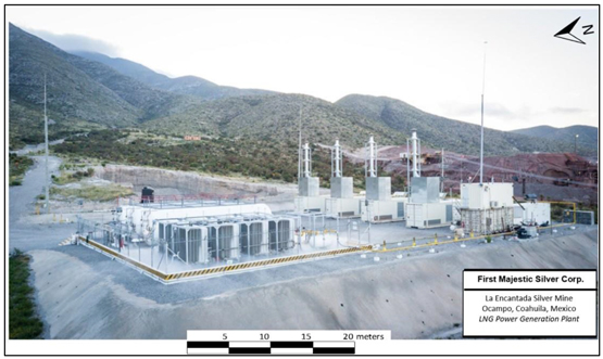
Note: Figure prepared by First Majestic, April 2025.
| 18.7. | Communications |
Communications to and from La Encantada use a satellite system, both for wireless data transfer and for the voice system. La Encantada has a site radio system enabling communications between supervisors, site management, and surface vehicle operators.
| 18.8. | Water Supply |
Fresh water for the offices and employee housing is obtained from a well located in the underground mine.
Industrial water for the mine and plant is obtained from a series of wells located 25 km from the La Encantada mine. This water is pumped to site and stored in a series of storage tanks located throughout the plant and mine facilities.
| 174 | September 2025 |
| La Encantada Silver Mine Coahuila, Mexico NI 43-101 Technical Report on Mineral Resource and Mineral Reserve Estimates |
|
| 19. | MARKET CONSIDERATION AND CONTRACTS |
The end product from the La Encantada mine comes in the form of silver doré bars. The physical silver doré bars contain approximately 60–85% silver in weight, plus other impurities. Doré bars are delivered to refineries where they are refined to commercially marketable 99.9% pure silver.
| 19.1. | Market Considerations |
Silver is considered a global and liquid commodity. Silver is predominantly traded on the London Bullion Market Association (LBMA) and COMEX in New York. The LBMA is the global hub of over-the-counter trading in silver and is this metal’s main physical market. ICE Benchmark Administration (IBA) provides the auction platform, methodology, as well as the overall administration and governance for the LBMA. Silver is quoted in US dollars per troy ounce.
| 19.2. | Commodity Price Guidance |
First Majestic has established a standard procedure to determine the medium- and long-term silver metal price guidance to be used for Mineral Resource and Mineral Reserves estimates. This procedure considers the consensus of future metal price forecasts from various sources including major Canadian and global banks, projections from financial analysts specializing in the mining and metals industry, and metal price forecasts used by peer mining companies in public disclosures.
Based on the above information, a recommendation as to acceptable consensus pricing is put forward by First Majestic’s QP to the company executives, and a decision is made to set the metal price guidance for Mineral Resource and Mineral Reserve estimates. This guidance is updated at least annually, or on an as-required basis.
The metal prices used for the December 2024 Mineral Resource and Mineral Reserve estimates were US$28.00/oz silver for Resources and US$26.00/oz for Reserves.
Foreign exchange rates used in the cost estimates and in the LOM model were and USD: MXN 19.50.
| 19.3. | Product and Sales Contracts |
First Majestic sells silver produced at the La Encantada mine through a select group of international metal brokers who serve as intermediaries between the Company and the London Bullion Market Association (LBMA). First Majestic delivers its production to a number of refineries, and once they have refined the silver to commercial grade, the refineries then transfer the silver to the physical market for consumption. First Majestic transfers risk at the time it delivers its doré from the processing plant to the armoured truck services that are under contract to the refineries. First Majestic normally receives up to 97% of the value
| 175 | September 2025 |
| La Encantada Silver Mine Coahuila, Mexico NI 43-101 Technical Report on Mineral Resource and Mineral Reserve Estimates |
|
of its sales of doré on delivery to the refinery, depending on the timing of sales with the metals broker, with final settlements upon out-turn of the refined metals, less processing costs.
Contracts with refining companies as well as metals brokers and traders are tendered periodically and re-negotiated as required. First Majestic continually reviews its cost structures and relationships with refining companies and metal traders to maintain the most competitive pricing possible.
| 19.4. | Royalty Agreement |
First Majestic has a royalty agreement with Metalla Royalty & Streaming for 100% of gold production on the first 1,000 payable ounces annually at La Encantada.
| 19.5. | Deleterious Elements |
The silver doré bars purity has been historically between 60–85%. Current production projections are showing concentration of silver in the doré in the lower part of that range, due to the presence of base metals such as copper, lead, and zinc. Considering the characteristics of the mineralized material, the processing practice, and the selling agreement in place, it is reasonable to expect that the La Encantada mine will be able to maintain the ability to sale its silver doré bars with its current purchaser.
| 19.6. | Supply and Services Contracts |
Contracts and agreements are currently in place for the supply of goods and services necessary for the mining operations. These include, but are not limited to, contracts for diamond drilling services, mine development, waste and ore haulage, maintenance service for the mining equipment, specialized maintenance service for plant equipment, supply of diesel for mobile equipment operation, supply of LNG for power generation, supply of explosives, supply of process reagents including sodium cyanide, and transportation and logistics services including infrastructure maintenance, catering and personnel transportation.
| 19.7. | Comments on Section 19 |
The doré produced by the mine is readily marketable.
Metal prices are set corporately for Mineral Resource and Mineral Reserve estimation. The QP has reviewed the consensus future metal price forecasts and the internal analysis results and considers them reasonable to support the metal price assumptions used in this Technical Report.
In the opinion of the QP, the terms, rates and charges set in the relevant service contracts and supply agreements for the mining operation are within industry practice in Mexico.
| 176 | September 2025 |
| La Encantada Silver Mine Coahuila, Mexico NI 43-101 Technical Report on Mineral Resource and Mineral Reserve Estimates |
|
The QP has reviewed commodity pricing assumptions, marketing assumptions and the current major contract areas, and considers the information acceptable for use in estimating Mineral Reserves and in the economic analysis that supports the Mineral Reserves.
| 177 | September 2025 |
| La Encantada Silver Mine Coahuila, Mexico NI 43-101 Technical Report on Mineral Resource and Mineral Reserve Estimates |
|
| 20. | ENVIRONMENTAL STUDIES, PERMITTING, AND SOCIAL OR COMMUNITY IMPACT |
In February 2024, the La Encantada mine was distinguished as a Socially Responsible Company (ESR) by the Mexican Center for Philanthropy (CEMEFI) for the third consecutive year. The ESR award is given to companies operating in Mexico that achieve high performance and commitment to sustainable economic, social, and environmentally positive impact in all corporate life areas, including business ethics, engagement with the community, and preservation of the environment. La Encantada completed the review process successfully by CEMEFI, which included an evaluation of policies, practices, procedures, and management systems to conduct business and community relations sustainably.
| 20.1. | Environmental Aspects, Studies and Permits |
| 20.1.1. | General |
First Majestic’s operating practices are governed by the principles set out in its Health and Safety Policy, Environmental Management Policy, Code of Business Conduct and Ethics, and other similar policies related to responsible business and mining. First Majestic’s Board of Directors and senior management team are committed to transparent disclosures of our sustainability management and performance, which included issuing our first biennial sustainability report in 2020, and a subsequent commitment to annual reporting beginning in early 2024.
| 20.1.2. | Environmental Compliance in Mexico |
Mining in Mexico is primarily regulated by Federal laws, though some areas require state or local approval. The principal agency promulgating environmental standards and regulating environmental matters in Mexico is Ministry of Environment and Natural Resources (SEMARNAT), alongside Federal delegations or state agencies of SEMARNAT.
An Environmental Impact Manifestation (MIA) must be prepared for submittal to SEMARNAT before applying for a license for a mining operation. The MIA must include an analysis of local climate, air quality, water, soil, vegetation, wildlife, and cultural resources in the project area, as well as a socioeconomic impact assessment. The Unique Environmental License (LAU) is based on an approved MIA and is required before the start of an industrial operation.
A permit must also be obtained from SEMERNAT for Risk Analysis (RA). A study must be conducted to identify and assess the potential environmental releases and risks, and to develop a plan to prevent and mitigate risks, and to respond to potential environmental emergencies. A strong emphasis is placed on the storage and handling of hazardous materials such as chemical reagents, fuel, and tailings.
The Federal Attorney for Environmental Protection (PROFEPA) is the responsible body for enforcement, public participation, and environmental education. After receiving an operation license, an agreement is
| 178 | September 2025 |
| La Encantada Silver Mine Coahuila, Mexico NI 43-101 Technical Report on Mineral Resource and Mineral Reserve Estimates |
|
setup between the operating company and the PROFEPA in order to follow-up on obligations, commitments, and monitoring of preventive activities.
A division of SEMARNAT, the National Water Commission (CONAGUA) is the authority for all water-related matters including activities that may impact surface water supply or quality, such as water use permits and fees, diversion of surface waters, constructions in significant drainages, or water discharge.
In Mexico, all land has a designated use. The majority of the land covering the La Encantada concessions is designated as agricultural or forest land. A Change of Land Use (CUS) permit is required for all production areas, and for potential areas of expanded production. The CUS study is based on federal forestry laws and regulations and requires an in-depth analysis of the current land use, the native flora and fauna, and an evaluation of the current and proposed uses of the land and their impact on the environment. The study requires that agreements exist with all affected surface rights holders, and that an acceptable reclamation and restoration plan is in place.
Mexican regulations require that the National Institute of Anthropology and History (INAH) reviews project plans prior to construction and inspects the project area for historical and archeological resources.
| 20.1.3. | Existing Environmental Conditions |
La Encantada is a mine with a long production history. Mining activity started in the 1950s and since that time several enterprises have operated in the area. As such, the vicinity had been affected by mining industrial activity before First Majestic began operations in the area in late 2006, including: vacant surface mine infrastructure in the form of old mining camps, areas of surface subsidence above historical mined areas, and low-grade mineralized stockpiles.
Environmental liabilities for the current operation are typical of those associated with an operating underground precious metals mine, including the future closure and reclamation of mine portals and ventilation infrastructure, access roads, processing facilities, power lines, low-grade TMFs, and all surface infrastructure that supports the operations.
| 20.1.4. | Relevant Environmental Impact Aspects |
| 20.1.4.1. | Wastewater Discharge |
The La Encantada mine does not discharge residual water to the environment, therefore, there are no wastewater discharge concession titles. Sanitary water is conducted through pipelines to a treatment plant built by First Majestic in 2010. From the treatment plant, water is pumped to the cyanidation process in Plant No. 2. The wastewater treatment and water control are necessary to comply with the maximum limits established by the Mexican norm. As water is limited in the region, wastewater control at La Encantada is a positive factor and helps to reduce the freshwater requirements for the process.
| 179 | September 2025 |
| La Encantada Silver Mine Coahuila, Mexico NI 43-101 Technical Report on Mineral Resource and Mineral Reserve Estimates |
|
| 20.1.4.2. | Processed Water Management |
The operation of tailings press filters allows for the recycling of up to 90% of the water utilized in the mill process. There is no underground water discharge, and an underground water well is used to supply potable water to the mine camp and offices for domestic services.
| 20.1.4.3. | Filtered Tailings Storage Facility No. 4 |
The Filtered Tailings Storage Facility No. 4 was constructed in 2008 when First Majestic expanded processing capacity. This facility is inactive at the report effective date. This facility was constructed by hauling filtered tailings with an overland belt conveyor system to the principal platform and depositing with a series of radial stackers to spread over the crest with track dozers. The potential landslide failure of the dam is considered low risk due to the low water content of the filtered tailings and the compaction gained by the spreading process. A local failure could occur only if torrential rain enters directly into the deposit and is not deflected by the diversion channel system. Nevertheless, a failure could impact seasonal creeks; therefore, First Majestic periodically reinforces the starter dam and executes maintenance on the pluvial channels to increase stability according to the geotechnical design. The environmental permit in place allows an eventual reclaiming of the tailings for reprocessing. Reclamation plans include geometric stabilization, covering the top and slopes with topsoil to promote reforestation in medium term, and final reforestation prior to the site closure.
| 20.1.4.4. | Filtered Tailings Storage Facility No. 5 |
The Filtered Tailings Storage Facility No. 5 started operations in 2014 and is currently active. FMSC recently received environmental permits for an expansion which adds 7.1 Mt representing 5.9 years and total capacity of 7.4 years, which is sufficient to support the LOM plan. The updated design of the FTSF 5 expansion included water surface management improvements with a diversion channel at the East of the watershed at maximum capacity elevation and a contact water pond at the Northeast. Finally, an instrumentation system was installed during the last geotechnical exploration which includes piezometers to monitor the phreatic level and monoliths to evaluate the deformation (if any).
| 20.1.4.5. | Plant No. 1 |
Plant No. 1 was built and operated as a flotation circuit plant. The flotation circuit is not currently in use, and only the crushing and milling sections and pumping systems are operating. If not reactivated, the flotation circuit will be required to be included in the closure and reclamation plans.
| 20.2. | Summary of Relevant Environmental Obligations |
The following is a description of the principal obligations relating to environmental matters for the La Encantada mine.
| 180 | September 2025 |
| La Encantada Silver Mine Coahuila, Mexico NI 43-101 Technical Report on Mineral Resource and Mineral Reserve Estimates |
|
| • | Yearly operation report (COA): A report submitted annually, which contains environmental information on the impact of the operation of the mine in regard to water, air, waste discharge, materials, and production. |
| • | Hazardous waste declaration: Records of the handling, storage, and final disposal of hazardous materials from the mining and processing operations. |
| • | Water usage right: A quarterly record and rights payment for water usage. |
| • | Monitoring plan for water, air, waste discharge and noise: This plan is prepared in accordance with the different authorizations and conditions set in the official Mexican norms. |
| • | Power generation record: A monthly report on electricity generation, as well as an annual fee for supervision of the Energy Regulatory Commission. |
| 20.3. | Permitting |
The La Encantada mine holds major environmental permits and licenses required by the Mexican authorities to carry out mineral extracting activities and has the necessary permits for current mining and processing operations, such as an operating license for mining and mineral processing activities, a mine water use permit, an EIA for the La Encantada mine, processing plants and TMF, and a permit for power generation.
On May 8, 2023, the Mexican Government enacted a decree amending several provisions of the Mining Law, the Law on National Waters, the Law on Ecological Equilibrium and Environmental Protection and the General Law for the Prevention and Integral Management of Waste (the “Decree”), which became effective on May 9, 2023. The Decree amends the mining and water laws, including: (i) the duration of the mining concession titles, (ii) the process to obtain new mining concessions (through a public tender), (iii) imposing conditions on water use and availability for the mining concessions, (iv) the elimination of “free land and first applicant” scheme; (iv) new social and environmental requirements in order to obtain and keep mining concessions, (v) the authorization by the Mexican Ministry of Economy of any mining concession’s transfer, (vi) new penalties and cancellation of mining concessions grounds due to non-compliance with the applicable laws, (vii) the automatic dismissal of any application for new concessions, and (viii) new financial instruments or collaterals that should be provided to guarantee the preventive, mitigation and compensation plans resulting from the social impact assessments, among other amendments. Additionally, on March 18, 2025, the new legislative framework for the hydrocarbon sector in Mexico was published in the Federal Official Gazette. This framework introduces specific permitting requirements for various hydrocarbons, including diesel.
These amendments are expected to have an impact on our current and future exploration activities and operations in Mexico, and the extent of such impact is yet to be determined but could be material for the Company. On June 7, 2023, the Senators of the opposition parties (PRI, PAN, and PRD) filed a constitutional action against the Decree, which is pending to be decided by Plenary of the Supreme Court of Justice.
During the second quarter of 2023, the Company filed various amparo lawsuits, challenging the constitutionality of the Decree. As of the date of this Technical Report, these amparos filed by First
| 181 | September 2025 |
| La Encantada Silver Mine Coahuila, Mexico NI 43-101 Technical Report on Mineral Resource and Mineral Reserve Estimates |
|
Majestic, along with numerous amparos in relation to the Decree that have been filed by other companies, are still pending before the District or Collegiate Courts. On July 15, 2024, the Supreme Court of Justice in Mexico suspended all ongoing amparo lawsuits against the Decree whilst the aforementioned constitutional action is being considered by the Supreme Court. As of the date of this Technical Report, the Supreme Court has not yet rendered an official ruling on the constitutional action against the Decree that was brought by the opposition parties within the Mexican government.
Certain revisions were made in 2023 to Mexican laws affecting the mining sector. This TRS reflects the Company’s understanding of the laws that affect the Company in light of these revisions. It should be noted that the current and revised laws are subject to ongoing interpretation and that in many instances the revised laws require implementing regulations, which have not yet been promulgated, for their impact to be fully assessed.
| 20.3.1. | Current Permits |
La Encantada is an operating mine, and as such it currently holds all major environmental permits and licenses required by the Mexican authorities to conduct mineral extracting activities. Table 20-1 lists relevant permits granted to La Encantada.
Table 20-1: Major Permits granted to La Encantada
| Permit | Date Granted | Document No. | Status | Expiration Date |
||||
| Environmental Licence (LAU) | Dec., 2020 | LAU-05-023-047 | Current | Permanent | ||||
| Groundwater use permit | Oct., 2008 | BOO.E.21.1.-2470/2008 | Current | Permanent | ||||
| Permit for electrical power generation | Aug., 2013 | E/134/GEN/99 | Current | Permanent | ||||
| EIA, TMFs | Mar., 2015 | S.G.P.A./496/COAH/2015 | Current | 2027 | ||||
| EIA, TMF-5 Expansion | Oct., 2024 | S.G.P.A./1214/COAH/2024 | Current | 2035 | ||||
| CUS, TMF-5 Expansion | Feb., 2025 | SGPA-UARN/207/COAH/2025 | Current | 2036 | ||||
| EIA, Roasting | Nov., 2017 | S.G.P.A./2045/COAH/2017 | Current | 2032 | ||||
| EIA, Exploration | Aug., 2020 | S.G.P.A./618/COAH/2020 | Current | 2026 | ||||
| 20.3.2. | Permits in Process |
The following is a list of the permits in process for La Encantada Silver Mine:
| • | A Preventive Report (IP) for exploration drilling of a secondary water well. |
To the extent known, there is no indication that this permit will not be granted, as the application is following its due course.
| 182 | September 2025 |
| La Encantada Silver Mine Coahuila, Mexico NI 43-101 Technical Report on Mineral Resource and Mineral Reserve Estimates |
|
| 20.4. | Mine Closure Aspects |
The plan for restoration and closure of the La Encantada mining site is based on the policies and terms documented in the commitments established in the Asset Retirement Obligations (ARO). The restoration plan includes an estimate of the investment that will be required for the support and execution of those works and activities that will return the land to a predetermined state once the activities associated with the mining operation have ceased.
First Majestic records a decommissioning liability for the estimated reclamation and closure of the Property, including site rehabilitation and long-term treatment and monitoring costs, discounted to net present value (NPV).
The NPV is determined using the liability-specific risk-free interest rate. The estimated NPV of reclamation and closure cost obligations is re-measured on an annual basis or when changes in circumstances occur and/or new material information becomes available. Increases or decreases to the obligations arise due to changes in legal or regulatory requirements, the extent of environmental remediation required, cost estimates and the discount rate applied to the obligation. The NPV of the estimated cost of these changes is recorded in the period in which the change is identified and quantifiable. Reclamation and closure cost obligations relating to operating mine and development projects are recorded with a corresponding increase to the carrying amounts of related assets.
As of December 31, 2024, an amount of $11.38 M has been recorded as a decommissioning liability for La Encantada and is based on the following considerations:
| • | Sealing underground mines and associated installations; |
| • | Reclaiming the processing plant and above ground associated installations; |
| • | Closing, sealing, and reclaiming the TMFs; |
| • | Ancillary service buildings (offices, general service infrastructure, warehouse); |
| • | Reclaiming the waste-rock management facilities. |
| 20.5. | Social and Community Aspects |
To the extent known, there are no social issues that could materially impact MLS’ ability to conduct exploration and mining activities in the property. To maintain ongoing social support of the operation, First Majestic relies on its relationship with the local communities, labour unions, and the government regulators, which are presently businesslike and amicable.
The surface land litigation presented in Section 4.3 of this Technical Report is not believed to compromise the ability to operate but could result in negotiations which may imply a payment for the land if the litigation resolution is not in favor of the Company’s interests.
| 183 | September 2025 |
| La Encantada Silver Mine Coahuila, Mexico NI 43-101 Technical Report on Mineral Resource and Mineral Reserve Estimates |
|
21. CAPITAL AND OPERATING COST
First Majestic has operated the La Encantada mine since November 2006 and maintains a well-established cost management system and a good understanding of operating costs. Key-performance indicators (KPI’s) are compiled and analyzed on a monthly basis to monitor operational performance, assess financial results, and support economic projections. Key costs elements include:
| • | Staff and Labour costs; |
| • | Power and fuel consumption costs; |
| • | Explosives consumption and costs; |
| • | Drilling steel consumption and costs; |
| • | Contractor costs for development and production; |
| • | Ore and waste haulage costs; |
| • | Grinding media consumption and costs; |
| • | Reagents consumption and costs; |
| • | Maintenance parts and costs; |
| • | General overhead and administration related costs. |
| 21.1. | Sustaining Capital Costs |
Sustaining capital expenditures are budgeted on an as-needed basis, based on actual operating conditions at the mine and processing plant. The LOM plan includes estimates for sustaining capital to support ongoing mining and processing activities.
Sustaining capital will primarily be allocated to on-going waste development, infill drilling, mine equipment rebuilding, equipment overhauls or replacements, plant maintenance and on-going refurbishing, and the expansion of filtered tailings storage facilities (FTSF) as needed.
Sustaining capital expenditures have been estimated for the LOM plan based on anticipated operational requirements. The extent of exploration conducted to find new targets, with the objective of replacing and/or expanding the Mineral Resources will be dependent on the success of exploration and core drilling programs. Due to the uncertainty of the exploration success, the potential new sources of mineralization are not included in the LOM plan. Sustaining capital is focused on maintaining current operational capacities, plant infrastructure, and equipment performance, while expansionary capital is focused on expanding new sources of mineralization. Table 21-1 presents the summary of the sustaining and expansionary capital expenditures.
| 184 | September 2025 |
| La Encantada Silver Mine Coahuila, Mexico NI 43-101 Technical Report on Mineral Resource and Mineral Reserve Estimates |
|
Table 21-1: La Encantada Mining Capital Costs Summary (Sustaining Capital)
|
Type (M USD) |
Total | 2025 | 2026 | 2027 | ||||||||||||
| Mine Development |
$ | 16.6 | $ | 5.6 | $ | 5.6 | $ | 5.4 | ||||||||
| Property, Plant & Equipment |
$ | 12.4 | $ | 4.2 | $ | 4.2 | $ | 4.0 | ||||||||
| Other Sustaining Costs |
$ | 4.1 | $ | 1.3 | $ | 1.6 | $ | 1.2 | ||||||||
|
|
|
|
|
|
|
|
|
|||||||||
| Total Sustaining Capital Costs |
$ | 33.0 | $ | 11.0 | $ | 11.4 | $ | 10.7 | ||||||||
|
|
|
|
|
|
|
|
|
|||||||||
| Near Mine Exploration |
$ | 1.5 | $ | 0.5 | $ | 0.5 | $ | 0.5 | ||||||||
|
|
|
|
|
|
|
|
|
|||||||||
| Total Capital Costs |
$ | 34.6 | $ | 11.5 | $ | 11.9 | $ | 11.2 | ||||||||
|
|
|
|
|
|
|
|
|
|||||||||
| 21.2. | Operating Costs |
The cost inputs in the economic model supporting the LOM are based on site actuals and contractor quotes, the majority of which are priced in Mexican pesos and converted to US dollars (e.g., labour, various supplies, etc.). While some variance may occur between the estimated and actual costs, the total mining and processing costs are expected to be within ±15% of the estimates. Given the current level of detail and operating experience at La Encantada, these estimates are considered sufficient to support the Mineral Reserves stated.
A summary of the La Encantada operating costs resulting from the LOM plan and the associated economic model used for assessing economic viability is presented in Table 21-2. A summary of the annual operating expenses is provided in Table 21-3.
Table 21-2: La Encantada Operating Costs
| Type |
$/tonne milled | |||
| Mining Cost |
15 | |||
| Processing Cost |
20.7 | |||
| Indirect Costs |
13.4 | |||
|
|
|
|||
| Total Production Cost |
49.1 | |||
|
|
|
|||
| Selling Cost |
0.8 | |||
|
|
|
|||
| Total Cash Cost |
49.9 | |||
|
|
|
|||
Table 21-3: La Encantada Annual Operating Costs
|
Type (M USD) |
Total | 2025 | 2026 | 2027 | ||||||||||||
| Mining Cost |
$ | 52.8 | $ | 17.7 | $ | 17.9 | $ | 17.2 | ||||||||
| Processing Cost |
$ | 72.7 | $ | 24.4 | $ | 24.6 | $ | 23.7 | ||||||||
| Indirect Costs |
$ | 47.2 | $ | 15.8 | $ | 16.0 | $ | 15.4 | ||||||||
|
|
|
|
|
|
|
|
|
|||||||||
| Total Production Cost |
$ | 172.7 | $ | 58.0 | $ | 58.4 | $ | 56.3 | ||||||||
|
|
|
|
|
|
|
|
|
|||||||||
| Selling Costs |
$ | 2.7 | $ | 0.9 | $ | 0.9 | $ | 0.9 | ||||||||
|
|
|
|
|
|
|
|
|
|||||||||
| Total Cash Cost |
$ | 175.5 | $ | 58.9 | $ | 59.3 | $ | 57.2 | ||||||||
|
|
|
|
|
|
|
|
|
|||||||||
| 185 | September 2025 |
| La Encantada Silver Mine Coahuila, Mexico NI 43-101 Technical Report on Mineral Resource and Mineral Reserve Estimates |
|
22. ECONOMIC ANALYSIS
First Majestic is using the provision for producing issuers, whereby producing issuers may exclude the information required under Item 22 for technical reports on properties currently in production and where no material expansion of current production is planned.
An economic analysis to support presentation of Mineral Reserves was conducted. Under the assumptions presented in this Technical Report, the operations show a positive cash flow, and can support Mineral Reserve estimation.
| 186 | September 2025 |
| La Encantada Silver Mine Coahuila, Mexico NI 43-101 Technical Report on Mineral Resource and Mineral Reserve Estimates |
|
23. ADJACENT PROPERTIES
This section is not relevant to this Technical Report.
| 187 | September 2025 |
| La Encantada Silver Mine Coahuila, Mexico NI 43-101 Technical Report on Mineral Resource and Mineral Reserve Estimates |
|
24. OTHER RELEVANT DATA AND INFORMATION
This section is not relevant to this Technical Report.
| 188 | September 2025 |
| La Encantada Silver Mine Coahuila, Mexico NI 43-101 Technical Report on Mineral Resource and Mineral Reserve Estimates |
|
25. INTERPRETATION AND CONCLUSIONS
The following interpretations and conclusions are a summary of the QPs’ opinions based on the information presented in this Technical Report.
| 25.1. | Mineral Tenure, Surface Rights and Agreements |
Information provided by First Majestic technical and legal experts supports that the mining tenure held is valid and is sufficient to support declaration of Mineral Resources and Mineral Reserves; La Encantada has adequate mineral concessions and surface rights to support mining operations over the planned LOM presented in this Technical Report.
For exploration purposes, if new areas of investigation are targeted, it is expected that there will be a need to formalize agreements with surface landowners.
First Majestic has agreements with the landowners in the area and some of these agreements may be subject to renegotiation from time to time. Material changes to the existing agreements may have a significant impact on operations at La Encantada.
If First Majestic is not able to reach an agreement for the use of the land with surface owners, then First Majestic may be required to pay compensation for the land use and/or modify its operations or plans for the exploration and development of its mines.
| 25.2. | Geology and Mineralization |
The current understanding of mineralization and alteration styles, as well as the structural and lithological controls on mineralization at La Encantada are sufficient to support the Mineral Resource and Mineral Reserve estimations.
The silver mineral deposits at La Encantada are high-temperature polymetallic replacement deposits hosted in sedimentary carbonate rocks related to felsic intrusions and controlled by local and regional structures. Carbonate replacement deposits are characterized by irregularly shaped pods, pipes and massive lenses, and tabular masses of oxides. Some replacement deposits are associated with skarn alteration and mineralization can also hosted be by sedimentary carbonate rocks.
| 25.3. | Exploration and Drilling |
The exploration programs completed to date are appropriate for the mineralization styles. Sampling methods (core drill hole and channel sampling) and data collection are acceptable given the deposit dimensions, mineralization true widths, and the nature of the deposits. The programs are reflective of
| 189 | September 2025 |
| La Encantada Silver Mine Coahuila, Mexico NI 43-101 Technical Report on Mineral Resource and Mineral Reserve Estimates |
|
industry-standard practices and can be used in support of Mineral Resource and Mineral Reserve estimation.
| 25.4. | Data Analysis |
Collar, downhole survey, lithology, core recovery, specific gravity and assay data collected are considered suitable to support Mineral Resource estimation. Sample preparation, analysis, and quality-control measures meet current industry standards and provide reliable silver results.
| 25.5. | Metallurgical Testwork |
The La Encantada mine is an operational facility where the metallurgical test data supporting the initial plant design has been validated over the years through consistent plant operating results, along with more recent metallurgical studies. The analysis presented in this Technical Report is based on historical plant data, mineralogical studies, and plant performance tests. Monthly composite samples are analyzed to monitor the metallurgical performance of the material fed into the processing plant, and the test results have demonstrated good repeatability when compared to actual plant performance.
Since January 2013, First Majestic has conducted tests to estimate the Bond Work Index (BWi) of monthly composite samples. These tests, performed on Run-of-Mine (ROM) material, have shown low variability in the BWi results. In addition to standard tests under normal plant conditions, monthly composite metallurgical investigations are conducted to evaluate the impact of key processing variables. The goal of this ongoing program is to identify opportunities for optimizing silver recoveries, address operational challenges and propose solutions.
The maturity of the La Encantada processing operation, established metallurgical monitoring practices, and knowledge of the mineralized material expected in the future underpin the assumptions regarding metallurgical recoveries used in the LOM plan and the associated economic analysis supporting the Mineral Reserves. The projected average yearly silver recovery outlined in the LOM plan ranges from 60.0% to 70.0%. However, there is a risk that the assumed recovery levels may not be fully realized if the material processed in the future differs significantly from what has been treated historically.
The silver content in the doré produced at La Encantada ranges from 60% to 85%, influenced by the presence of copper, lead, and zinc. This variation in silver concentration affects the treatment charge, which is calculated based on the weight of the doré produced. A typical treatment charge has been factored into the cut-off grade and the economic evaluations used in the LOM plan.
| 190 | September 2025 |
| La Encantada Silver Mine Coahuila, Mexico NI 43-101 Technical Report on Mineral Resource and Mineral Reserve Estimates |
|
| 25.6. | Mineral Resource Estimates |
The Mineral Resource estimates for La Encantada are prepared in accordance with the 2014 CIM Definition Standards. The resource estimates are a reasonable representation of the mineralization found in the Project at the current level of sampling.
The estimates are based on the current database of exploration drill holes and production channel samples, underground level geological mapping, geological interpretation and model, surface topography, and underground mining development wireframes available as of December 31, 2024.
The Mineral Resources were classified into Indicated or Inferred confidence categories based on the following factors confidence in the geological interpretation and models, confidence in the continuity of metal grades, the sample support for the estimation and reliability of the sample data, and areas that were mined producing reliable production channel samples and detailed geological control.
Factors that may materially impact the Mineral Resource estimates include Metal price and exchange rate assumptions, changes to the assumptions used to generate the silver-equivalent grade cut-off grade, changes in local interpretations of mineralization geometry and continuity of mineralized zones, changes to geological and mineralization shape and geological and grade continuity assumptions, changes to geotechnical, mining, and metallurgical recovery assumptions, and assumptions as to the continued ability to access the site, retain mineral and surface rights titles, maintain environment and other regulatory permits, and maintain the social license to operate;
| 25.7. | Mineral Reserve Estimates |
The Mineral Reserves estimates for La Encantada include considerations for the underground mining methods in use, dilution, mining widths, mining extraction losses, metallurgical recoveries, permitting and infrastructure requirements.
Factors which may materially affect the Mineral Reserve estimates for La Encantada include fluctuations in commodity prices and exchange rates assumptions used; material changes in the underground stability due to geotechnical conditions that may increase unplanned dilution and mining loss; unexpected variations in equipment productivity; material reduction of the capacity to process the mineralized material at the planned throughput and unexpected reduction of the metallurgical recoveries; higher than anticipated geological variability; cost escalation due to external factors; changes in the taxation considerations; the ability to maintain constant access to all working areas; changes to the assumed permitting and regulatory environment under which the mine plan was developed; the ability to maintain mining concessions and/or surface rights; the ability to renew agreements with the different surface owners; and the ability to maintain the social and environmental licenses to operate.
| 191 | September 2025 |
| La Encantada Silver Mine Coahuila, Mexico NI 43-101 Technical Report on Mineral Resource and Mineral Reserve Estimates |
|
| 25.8. | Mine Plan |
Mining operations can be conducted year-round. The underground mine plan presented in this Technical Report was designed to deliver an achievable plant feed, based on the current knowledge of geological, geotechnical, geohydrological, mining and processing conditions. Production forecasts are based on current equipment and plant productivities.
In the opinion of the QP, it is reasonable to assume that if the sustaining capital expenditures expressed in the LOM plan are executed, the La Encantada mine will have the means to operate as planned.
The current mine life to 2027 is considered achievable based on the projected annual production rate and the estimated Mineral Reserves. There is upside if some or all of the Inferred Mineral Resources can be upgraded to higher confidence Mineral Resource categories.
| 25.9. | Processing |
The La Encantada process plant is in excellent operating condition, with over 20 years of successful operation. The plant’s design incorporates the comminution of Run-of-Mine (ROM) material and agitated tank-leaching, utilizing well-established technology. The plant enjoys high overall availability, and the risk of catastrophic failures or unplanned long shutdowns is minimal, thanks to the sustaining capital program outlined in the LOM plan and current budget.
In recent years, the installation of a larger ball mill has enhanced operational reliability, increasing the comminution capacity to 3,400 tonnes per day (tpd).
Further opportunities for operational expansion exist, including the potential for roasting manganese-encapsulated mineralized material, which could boost the plant’s capacity to process refractory mineralization and extend the life of the mine.
| 25.10. | Infrastructure |
La Encantada’s remote location has required the construction of substantial infrastructure, which has been developed during an extended period of active operation by First Majestic and the mine’s previous owners, Peñoles and Compañía Minera Los Angeles. Power supply to the mine, processing facilities and camp site is from diesel and natural gas generators provided by First Majestic. Potable water supply is also provided by First Majestic Most of the supplies and labour required for the operation are sourced from the city of Múzquiz, Coahuila, or directly from suppliers. The mine has all required infrastructure in place to support operations for the LOM plan presented in this Technical Report.
The capacity of the FTSF and planned FTSF expansion is sufficient to hold compacted filtered tailings generated from the production contained in the LOM plan.
| 192 | September 2025 |
| La Encantada Silver Mine Coahuila, Mexico NI 43-101 Technical Report on Mineral Resource and Mineral Reserve Estimates |
|
| 25.11. | Markets and Contracts |
The end product from the La Encantada mine is in the form of silver doré bars. The physical silver doré bars, usually containing between 60–85% silver in weight, are delivered to refineries where doré bars are refined to commercially marketable 99.9% pure silver and gold bars. The terms contained within the existing sales contracts are typical of, and consistent with, standard industry practices.
Selling costs, including freight, insurance, and representation, as well as refining charges, payable terms, deductions, and penalties terms for La Encantada doré bars, were reviewed by the QP and found to be in line with similar commercial conditions of metal producers in Mexico. All these costs have been incorporated into the long-term economic analysis.
| 25.12. | Permitting, Environmental and Social Considerations |
Permits held by First Majestic for La Encantada are sufficient to ensure that mining activities are conducted within the regulatory framework required by the Mexican government and that Mineral Resources and Mineral Reserves can be declared.
Closure provisions are appropriately considered in the mine plan and economic analysis.
| 25.13. | Capital and Operating Cost Estimates |
The capital and operating cost provisions for the LOM plan that supports La Encantada Mineral Reserves have been reviewed. The basis for the estimates is appropriate to the known mineralization, mining and production schedules, marketing plans, and equipment replacement and maintenance requirements.
Capital cost estimates include appropriate estimates for sustaining capital.
| 25.14. | Economic Analysis Supporting Mineral Reserve Declaration |
First Majestic is using the provision for producing issuers, whereby producing issuers may exclude the information required under Item 22 for technical reports on properties currently in production and where no material expansion of current production is planned.
An economic analysis to support presentation of Mineral Reserves was conducted. Under the assumptions presented in this Technical Report, the operations show a positive cash flow, and can support Mineral Reserve estimation.
| 193 | September 2025 |
| La Encantada Silver Mine Coahuila, Mexico NI 43-101 Technical Report on Mineral Resource and Mineral Reserve Estimates |
|
| 25.15. | Conclusions |
Under the assumptions used in this Technical Report, La Encantada has positive economics for the LOM plan, which supports the Mineral Reserve statement.
| 194 | September 2025 |
| La Encantada Silver Mine Coahuila, Mexico NI 43-101 Technical Report on Mineral Resource and Mineral Reserve Estimates |
|
26. RECOMMENDATIONS
The proposed work or studies presented here can be conducted concurrently with a total estimated expenditure of $21.2 to $31.2M.
| 26.1.1. | Exploration |
First Majestic has been successfully replacing depleted Mineral Resources through near-mine drilling at the La Encantada mine since acquiring the property in 2006. Mineralization remains open along strike to the northeast in the Vein systems. The La Encantada concessions cover 4,076 ha of prospective ground with some potential to host additional carbonate replacement deposits. Several brownfield prospects warrant continued exploration. Prospecting, mapping, and geochemical and geophysical surveys are expected to identify new prospects .
To maintain current and projected production levels and to potentially increase mineral resources, the following annual drilling programs are recommended.
| • | An annual 1,000 m infill sustaining drill program to support short-term production plans; |
| • | An annual 4,000 m near mine drill program to support mid-term production projections; |
| • | An annual 4,000 m brownfield surface drill program to identify additional mineralization. |
This 9,000 m annual exploration drill program is estimated to cost $1.2 M per year excluding related underground access development costs.
In addition, an annual prospect generation program consisting of prospecting, soil and rock geochemical surveys, mapping, and geophysical surveys is recommended. This annual prospect generation program is estimated to cost $200,000 per year.
The amounts and estimated cost of these recommended exploration programs should be reviewed annually as these recommendations are for an ongoing, multi-year drilling program.
| 26.1.2. | Roasting |
A study has determined that an estimated $20 million to $30 million is required for the necessary upgrades to the existing, inoperative roasting circuit. It is recommended to continue exploring opportunities to reduce capital costs and optimize the process to achieve a more cost-effective solution.
| 195 | September 2025 |
| La Encantada Silver Mine Coahuila, Mexico NI 43-101 Technical Report on Mineral Resource and Mineral Reserve Estimates |
|
| 27. | REFERENCES |
Addison, R. and Lopez L., 2009: Technical Report for the La Encantada Silver Mine, Coahuila State, Mexico. Pincock, Allen & Holt. 134 pp.
AMEC Foster Wheeler (2015): Mining Method Selection Trade-Off Study and Mine Design Revison A, prepared for First Majestic Silver Corp., 68 pp.
Barton, N., R. Lien and J. Lunde, 1974: Engineering Classification of Rock Masses for the Design of Tunnel Support. Rock Mechanics and Rock Engineering 6 (4): p. 189-236.
Bieniawski, Z.T., 1973: Engineering Classification of Jointed Rock Masses. Civil Engineering in South Africa, 15 (12), p. 335-343.
Bieniawski, Z. T., 1989. Engineering Rock Mass Classifications. New York: Wiley.
Boutilier B., Sinuhaji A., Mendoza, R., 2018: The Construction of Two Small-Scale Caving Mines at La Encantada Mine, Mexico, prepared for SME, 7 pp.
Campa, M. F., and Coney, P. J., 1983, Tectono-stratigraphic terranes and mineral resource distributions in Mexico, Canadian Journal of Earth Science, vol. 20, pp.1040 – 1051.
Canadian Institute of Mining, Metallurgy and Petroleum (CIM), 2014: CIM Definition Standards for Mineral Resources and Mineral Reserves, 9 pp.
CIM, 2019: Estimation of Mineral Resources and Mineral Reserves Best Practice Guidelines (MRMR Estimation Best Practice Guidelines), 74 pp.
CIM Mineral Resource & Mineral Reserve Committee, 2020: CIM Guidance on Commodity Pricing and Other Issues related to Mineral Resource and Mineral Reserve Estimation and Reporting., 9 pp.
Canadian Securities Administrators (CSA), 2011, National Instrument 43-101 Standards of Disclosure for Mineral Projects, 44 p.
Deere, D.U, 1989: Rock Quality Designation (RQD) after twenty years. U.S. Army Corps Engrs. Contract Report GL-89-1.
Diaz-Unzueta R., 1987, Geochemical and isotopic study of calcite stockworks at La Encantada mining district, Coahuila, Mexico: relationships with orebodies and implications for exploration, University of Arizona, Unpublished M.Sc. thesis, 121 p.
Diering, T., 2004: Combining Long Term Scheduling and Daily Draw Control for Block Cave Mines, Massmin 2004 Proceedings, Santiago, August, pp. 486-490.
Diering, T., 2004: Computational Considerations for Production Scheduling of Block Cave Mines, Massmin 2004 Proceedings, Santiago, August, pp. 135-140.
| 196 | September 2025 |
| La Encantada Silver Mine Coahuila, Mexico NI 43-101 Technical Report on Mineral Resource and Mineral Reserve Estimates |
|
González-Sánchez, F., Camprubí, A., González-Partida, E., Puente-Solís, R., Canet, C., Centeno-García, E. and Atudoréi, V., 2009, Regional stratigraphy and distribution of epigenetic stratabound celestine, fluorite, barite and Pb–Zn deposits in the MVT province of northeastern Mexico, Mineralium Deposita, Springer, vol. 44, pp. 343 – 361.
Herrera, G., Negrete, D., Sinuhaji, A., 2018: Support Elements and Monitoring Design for San Javier Breccia, Sublevel Caving Mine at La Encantada Mine. Prepared for SME, 5 pp.
Hoek, E., Kaiser P.K. and Bawden, W.F., 1995: Support of Underground Excavations in Hard Rock, Balkema. 215 pp.
Hoek, E., & Brown, E. T. (1997). Practical estimates of rock mass strength. International Journal of Rock Mechanics and Mining Sciences, 34(8), 1165–1186.
Ingeniería de Rocas LTDA (2013): Análisis Método de Explotación Mina La Encantada, October, prepared for First Majestic Silver Corp., 32 pp.
Itasca Consulting Group, Inc. (2011). FLAC—Fast Lagrangian Analysis of Continua, Ver. 7.0. Itasca Consulting Group, Inc.
Itasca Consulting Group (2020): Update of Subsidence Analysis Associated with Caving at La Encantada Silver Mine, prepared for First Majestic Silver Corp. 63 pp.
Kiyokawa M., 1977, Investigación Geológico Minera de la Porción Nor-Oriental del Estado de Coahuila, Consejo de Recursos Minerales, 34 p.
Laubscher, D.H., 1990: A geomechanics classification system for the rating of rock mass in mining. Journal of the Southern African Institute of Mining and Metallurgy, Vol. 90, no 10. pp 257-273.
Lozano, C. G., 1981, Reconocimiento estratigráfico del area La Encantada, Ocampo, Coahuila, Reporte Interno, Peñoles SA. de CV.
Lozej, G. P., and Beals, F., 1977, Stratigraphy and structure of La Encantada Mine area, Coahuila, Mexico, Geological Society of America Bulletin, vol. 88, pp. 1793 – 1807.
Megaw, P., Ruiz, J., and Titley, S., 1988, High temperature, carbonate-hosted Ag-Pb-Zn (Cu) deposits of northern Mexico, Economic Geology and the Bulletin of the Society of Economic Geologists, v. 83, pp. 1856 – 1885.
Mendoza Reyes, R., Vázquez Jaimes, M.E., Velador Beltran, J. and Oshust, P., 2015: Technical Report on Mineral Resource and Mineral Reserve Update for the La Encantada Silver Mine Ocampo, Coahuila, Mexico, 247 pp.
National Instrument 43-101 Standards of Disclosure for Mineral Projects, June 24, 2011, 44 p.
Negrete, D., 2014: Informe Tecnico Barrenacion Larga San Francisco, Internal Report prepared for First Majestic Silver Corp., 10 pp.
| 197 | September 2025 |
| La Encantada Silver Mine Coahuila, Mexico NI 43-101 Technical Report on Mineral Resource and Mineral Reserve Estimates |
|
Plumlee, G.S., Montour, M., Taylor, C.D., Wallace, A.R., and Klein, D.P., 1995, Polymetallic Vein and Replacement Deposits, in US Geological Survey, Open-File Report OFR-95-0831, Chapter 14, p. 121-129.
Ruiz, J., Sweeney, R., and Palacios, H., 1986, Geology and geochemistry of Naica, Chihuahua, Mexico, in Clark, K. F., Megaw, P. K. M., and Ruiz, J., eds., Lead-zinc-silver carbonate hosted deposits of northern Mexico, El Paso, Texas, Univ. Texas El Paso, Soc. Econ. Geologists Guidebook, pp. 305 – 310.
Sedlock, R. L., Ortega-Gutiérrez, F. and Speed, R. C., 1993, Tectonostratigraphic Terranes and Tectonic Evolution of Mexico, Geological Society of America, Special Paper 278, 153 p.
Solano B., 1991, Geology and mineralization of the La Encantada Mining District, Coahuila, Geological Society of America, The Geology of North America, vol. P-3, pp. 253 – 257.
Starling T., 2014, Structural Review of the La Encantada Mine, Coahuila, Mexico, Internal report prepared for First Majestic Silver Corp., 28 p.
Vakili, A. (2016). An improved unified constitutive model for rock material and guidelines for its application in numerical modelling. Computers and Geotechnics, 80, 261-282.
Zonge Engineering and Research Organization, Inc., 2009, Geophysical Survey Report: Natural Source AMT Survey for the La Encantada Project, La Encantada, Coahuila, Mexico, Internal Report Prepared for First Majestic Silver Corp., 35 p.
| 198 | September 2025 |
| La Encantada Silver Mine Coahuila, Mexico NI 43-101 Technical Report on Mineral Resource and Mineral Reserve Estimates |
|
| 28. | CERTIFICATES OF QUALIFIED PERSON |
| 199 | September 2025 |
CERTIFICATE OF QUALIFIED PERSON
Mr. Gonzalo Mercado, P.Geo.
Vice President Exploration and Technical Services
First Majestic Silver Corp.
Suite 1800 – 925 West Georgia Street
Vancouver, British Columbia, Canada, V6C 3L2
I, Gonzalo Mercado, P.Geo., am employed as “Vice-President, Exploration & Technical Services” with First Majestic Silver Corp. (“First Majestic”).
This certificate applies to the technical report “La Encantada Silver Mine, State of Coahuila, Mexico, NI 43-101 Technical Report on Mineral Resource and Mineral Reserve Estimates” that has an effective date of August 31, 2025 (the “Technical Report”).
I hold a degree in Geology (2004) from the Universidad Nacional de Tucuman, Argentina.
I am a Professional Geologist with Professional Geoscientists Ontario (P.Geo.), Membership #3139.
I have practiced my profession continuously for more than 20 years, and I have a considerable amount of experience in precious and base metal deposits in Mexico, the United States, Canada, Chile, and Argentina. My relevant experience in base and precious metal spans across all exploration stages as well as various aspects of the Technical Services including various corporate and senior management roles. I am currently responsible and have oversight for short and long-term mine planning, hydrogeology, rock mechanics, geotechnical engineering, topography and ventilation.
As a result of my experience and qualifications, I am a Qualified Person as defined in National Instrument 43-101 Standards of Disclosure for Mineral Projects (“NI 43-101”).
I have visited the La Encantada Mine on numerous occasions during 2021 to 2024, and my most recent site inspection occurred over the span of two days commencing on October 22nd to 23rd, 2024.
I am responsible for Chapters 2-10, 20, 23-25 and related sections of Chapters 1, 25, and 26 of the technical report.
I am not independent of First Majestic as that term is described in Section 1.5 of NI 43-101.
I have been involved with the La Encantada Silver Mine overseeing the development of Exploration since 2021 with the addition of Technical Services since mid-2023.
I have read NI 43-101, and the sections of the Technical Report for which I am responsible have been prepared in compliance with that Instrument.
As of the effective date of the Technical Report, to the best of my knowledge, information and belief, the sections of the technical report for which I am responsible contain all scientific and technical information that is required to be disclosed to make the Technical Report not misleading.
(signed) “Gonzalo Mercado”_
Gonzalo Mercado, P. Geo.
Dated: September 24, 2025
| 200 | September 2025 |
CERTIFICATE OF QUALIFIED PERSON
Karla Michelle Calderon Guevara, CPG
Senior Resource Geologist
First Majestic Silver Corp.
Suite 1800 – 925 West Georgia Street
Vancouver, British Columbia, Canada, V6C 3L2
I, Karla Michelle Calderon Guevara, CPG, am employed as “Senior Resource Geologist” with First Majestic Silver Corp. (“First Majestic”).
This certificate applies to the technical report “La Encantada Silver Mine, State of Coahuila, Mexico, NI 43-101 Technical Report on Mineral Resource and Mineral Reserve Estimates” that has an effective date of August 31, 2025 (the “Technical Report”).
I graduated from the Autonomous University of Chihuahua, Mexico with a bachelor’s degree in Geological Engineering degree in 2010.
I am a Certified Professional Geologist with the American Institute of Professional Geologists, CPG-12220.
I have practiced my profession continuously since 2010 and I have been involved in precious and base metal deposits in Mexico, the United States, and Northern Ireland. I have held various senior roles within the areas of mineral exploration, geological database administration, project management, geologic interpretation, three-dimensional geologic modeling, and resource estimation.
As a result of my experience and qualifications, I am a Qualified Person as defined in National Instrument 43-101 Standards of Disclosure for Mineral Projects (“NI 43-101”).
I worked full-time at La Encantada Silver Mine as Database Administrator and Resource Geologist from 2017 to 2020. I held this position until July 2021 when I was promoted to Senior Resource Geologist overseeing other sites with continued full responsibility and accountability for La Encantada Silver Mine. My most recent site visit was from December 3rd to December 9th, 2024.
I am responsible for Chapter 14, and related sections of Chapters 1, 25, and 26 of the Technical Report.
I am not independent of FMS as that term is described in Section 1.5 of NI 43-101.
I have been directly involved with La Encantada Silver Mine in my role as Senior Resource Geologist since 2017.
I have read NI 43-101, and the sections of the Technical Report for which I am responsible have been prepared in compliance with that Instrument.
As of the effective date of the Technical Report, to the best of my knowledge, information and belief, the sections of the technical report for which I am responsible contain all scientific and technical information that is required to be disclosed to make the Technical Report not misleading.
(signed) “Karla Michelle Calderon Guevara”_
Karla Michelle Calderon Guevara, CPG
Dated: September 24, 2025
| 201 | September 2025 |
CERTIFICATE OF QUALIFIED PERSON
María Elena Vázquez Jaimes, P.Geo.
Geological Database Manager,
First Majestic Silver Corp.
Suite 1800 – 925 West Georgia Street
Vancouver, British Columbia, Canada, V6C 3L2
I, María Elena Vázquez Jaimes, P.Geo., am employed as “Geological Database Manager” with First Majestic Silver Corp. (“First Majestic”).
This certificate applies to the technical report “La Encantada Silver Mine, State of Coahuila, Mexico, NI 43-101 Technical Report on Mineral Resource and Mineral Reserve Estimates” that has an effective date of August 31, 2025 (the “Technical Report”).
I graduated from the National Autonomous University of Mexico with a Bachelor in Geological Engineering degree in 1995 and obtained a Master of Science degree in Geology from the “Ensenada Center for Scientific Research and Higher Education”, Ensenada, BC, Mexico, in 2000.
I am a member of the Association of Professional Engineers and Geoscientists of British Columbia (P.Geo. #35815).
I have practiced my profession continuously since 1995. I have held positions working with geological databases, conducting quality assurance and quality control, performing data verification activities, supervising logging, and sampling procedures for mining companies in Canada, Mexico, Peru, Ecuador, Brazil, Colombia, and Argentina. I have served as the Geologic Database Manager for First Majestic since 2013, and I direct the QA/QC programs, sampling and assay procedures, and database verification for the Mexico mines.
As a result of my experience and qualifications, I am a Qualified Person as defined in National Instrument 43-101 Standards of Disclosure for Mineral Projects (“NI 43-101”).
I visited La Encantada Silver Mine on several occasions since 2013. My most recent site visit was from March 5th to March 9th, 2025.
I am responsible for Chapters 11, 12 and related sections of Chapters 1, 25, and 26 of the Technical Report.
I am not independent of First Majestic as that term is described in Section 1.5 of NI 43-101.
I have been directly involved with La Encantada Silver Mine in my role as the Geological Database Manager since 2013.
I have read NI 43-101, and the sections of the Technical Report for which I am responsible have been prepared in compliance with that Instrument.
As of the effective date of the Technical Report, to the best of my knowledge, information and belief, the sections of the Technical Report for which I am responsible contain all scientific and technical information that is required to be disclosed to make the Technical Report not misleading.
(signed) “María Elena Vázquez Jaimes”_
María Elena Vázquez Jaimes, P.Geo.
Dated: September 24, 2025
| 202 | September 2025 |
CERTIFICATE OF QUALIFIED PERSON
Mr. Andrew Pocock, P.Eng.
Director of Reserves
First Majestic Silver Corp.
Suite 1800 – 925 West Georgia Street
Vancouver, British Columbia, Canada, V6C 3L2
I, Andrew Pocock, P.Eng., am employed as “Director of Reserves” with First Majestic Silver Corp. (“First Majestic”).
This certificate applies to the technical report “La Encantada Silver Mine, State of Coahuila, Mexico, NI 43-101 Technical Report on Mineral Resource and Mineral Reserve Estimates” that has an effective date of August 31, 2025 (the “Technical Report”).
I hold a degree in Mining Engineering (2012) from the University of Adelaide, Australia. I am a Professional Engineer with Engineers & Geoscientists of British Columbia (EGBC), Licence # 52078. I have practiced my profession continuously for more than 14 years. I have gained relevant experience in mining operations, design & planning, projects, risk management, and studies as both an employee and consultant across precious and base metals deposits primarily in Australia, Canada, the United States, and Mexico.
As a result of my experience and qualifications, I am a Qualified Person as defined in National Instrument 43-101 Standards of Disclosure for Mineral Projects (“NI 43-101”).
I have visited the La Encantada Silver Mine once in February 2025.
I am responsible for Sections 15, 16, 18, 19, 21, 22 and related sections of Chapters 1, 25, and 26 of the Technical Report of the Technical Report.
I am not independent of First Majestic as that term is described in Section 1.5 of NI 43-101.
I have been involved with the La Encantada Silver Mine since mid-2024 overseeing mine planning, ventilation, rock mechanics, surveying, hydrogeology, and geotechnical engineering.
I have read NI 43-101, and the sections of the Technical Report for which I am responsible have been prepared in compliance with that Instrument.
As of the effective date of the Technical Report, to the best of my knowledge, information and belief, the sections of the technical report for which I am responsible contain all scientific and technical information that is required to be disclosed to make the Technical Report not misleading.
(signed) “Andrew Pocock”_
Andrew Pocock, P.Eng.
Dated: September 24, 2025
| 203 | September 2025 |
CERTIFICATE OF QUALIFIED PERSON
Michael Jarred Deal
Vice President of Metallurgy & Innovation
First Majestic Silver Corp.
Suite 1800 – 925 West Georgia Street
Vancouver, British Columbia, Canada, V6C 3L2
I, Michael Jarred Deal, RM SME, am employed as “Vice-President, Operations” with First Majestic Silver Corp. (“First Majestic”).
This certificate applies to the technical report entitled “La Encantada Silver Mine, State of Coahuila, Mexico, NI 43-101 Technical Report on Mineral Resource and Mineral Reserve Estimates” that has an effective date of August 31, 2025 (the “Technical Report”).
I graduated from the Colorado School of Mines in 2009 with a Bachelor of Science Degree in Chemical Engineering and from Arizona State University in 2024 with a Master of Business Administration. I am a Registered Member of the Society for Mining, Metallurgy, and Exploration (#4152005).
I have practiced my profession continuously since 2009 and have been involved in precious and base metal mine projects and operations in Nevada, South Carolina, New Mexico, Colorado, and Mexico. My relevant experience in base and precious metal spans across managing all types of mineral processing facilities and projects including roasting, autoclaving, heap leaching, and concentrators. I have worked in Operations Management positions along with corporate technical support roles serving as a Process and Projects Subject Matter Expert.
I have been involved with the La Encantada Mine since 2023 overseeing all processing and metallurgical activities. I visited the La Encantada mine on two occasions in 2024 with the most recent in October 2024.
As a result of my experience and qualifications, I am a Qualified Person as defined in National Instrument 43-101 Standards of Disclosure for Mineral Projects (“NI 43-101”).
I am responsible for Chapters 13, 17, and related sections of Chapters 1, 25, and 26 of the Technical Report.
I am not independent of First Majestic as that term is described in Section 1.5 of NI 43-101.
I have read NI 43-101, and the sections of the Technical Report for which I am responsible have been prepared in compliance with that Instrument.
As of the effective date of the Technical Report, to the best of my knowledge, information and belief, the sections of the technical report for which I am responsible contain all scientific and technical information that is required to be disclosed to make the Technical Report not misleading.
(signed) “Michael Jarred Deal”_
Michael Jarred Deal, RM SME
Dated: September 24, 2025
| 204 | September 2025 |