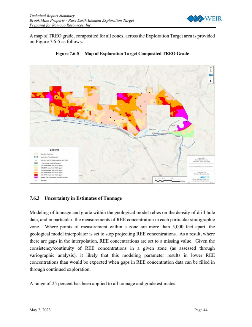
UNITED
STATES
SECURITIES AND EXCHANGE COMMISSION
Washington, D.C. 20549
FORM 8-K
CURRENT REPORT
Pursuant to Section 13 or 15(d) of the Securities Exchange Act of 1934
Date of Report (Date of earliest event reported): May 3, 2023
Ramaco Resources, Inc.
(Exact name of Registrant as specified in its Charter)
| Delaware | 001-38003 | 38-4018838 |
| (State
or other jurisdiction of incorporation) |
(Commission File Number) | (IRS Employer Identification No.) |
250 West Main Street, Suite 1900
Lexington, Kentucky 40507
(Address of principal executive offices)
Registrant’s telephone number, including area code: (859) 244-7455
Securities registered pursuant to Section 12(b) of the Act:
| Title of each class | Trading Symbol(s) | Name of each exchange on which registered |
| Common Stock, $0.01 par value | METC | NASDAQ Global Select Market |
| 9.00% Senior Notes due 2026 | METCL | NASDAQ Global Select Market |
Check the appropriate box below if the Form 8-K filing is intended to simultaneously satisfy the filing obligation of the registrant under any of the following provisions:
| ¨ | Written communications pursuant to Rule 425 under the Securities Act (17 CFR 230.425) |
| ¨ | Soliciting material pursuant to Rule 14a-12 under the Exchange Act (17 CFR 240.14a-12) |
| ¨ | Pre-commencement communications pursuant to Rule 14d-2(b) under the Exchange Act (17 CFR 240.14d-2(b)) |
| ¨ | Pre-commencement communications pursuant to Rule 13e-4(c) under the Exchange Act (17 CFR 240.13e-4(c)) |
Indicate by check mark whether the registrant is an emerging growth company as defined in Rule 405 of the Securities Act of 1933 (§ 230.405 of this chapter) or Rule 12b-2 of the Securities Exchange Act of 1934 (§240.12b-2 of this chapter).
Emerging growth company ¨
If an emerging growth company, indicate by check mark if the registrant has elected not to use the extended transition period for complying with any new or revised financial accounting standards provided pursuant to Section 13(a) of the Exchange Act. ¨
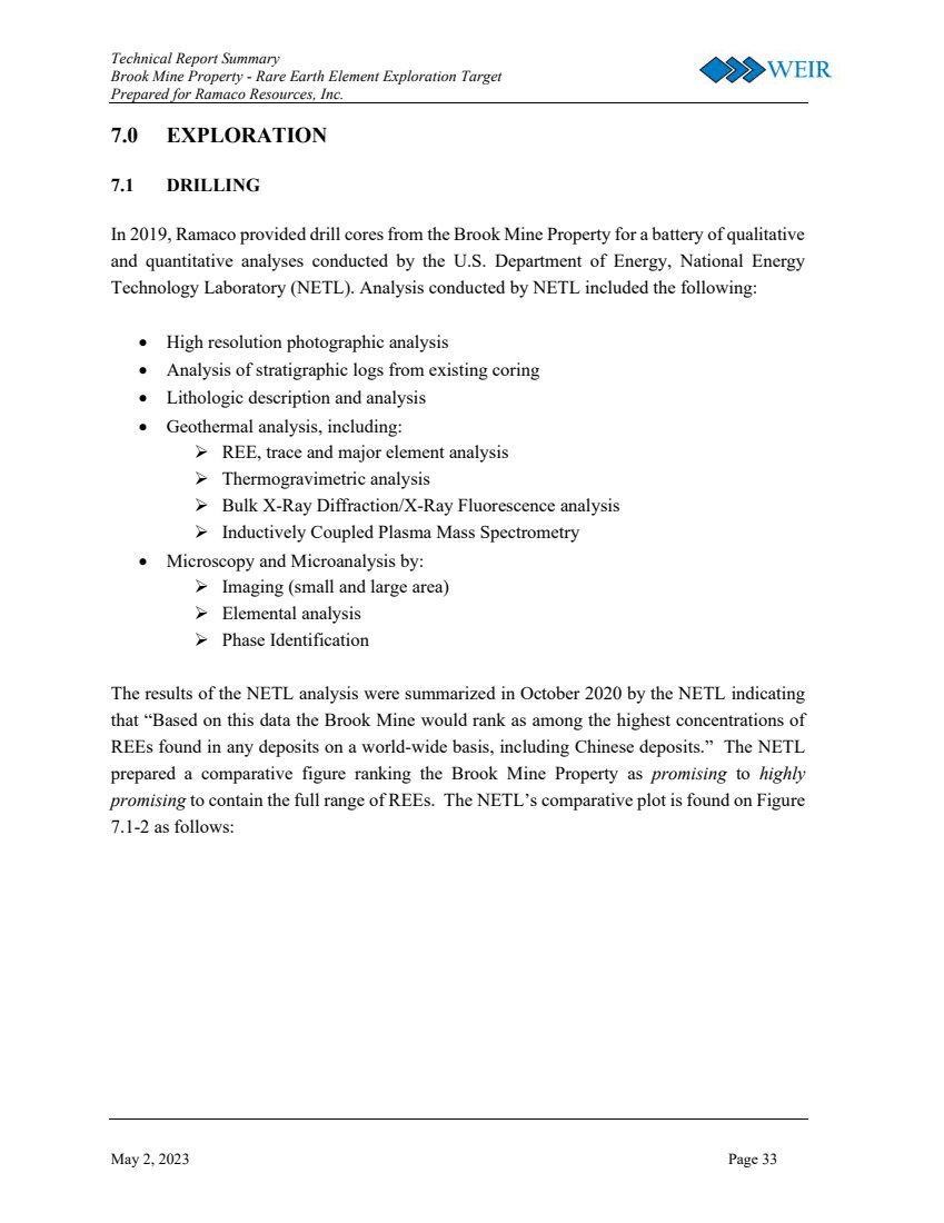
Item 2.02. Results of Operations and Financial Condition.
On May 3, 2023, Ramaco Resources, Inc. (the “Company”) issued a press release reporting its financial and operating results for the first quarter 2023 (the “Earnings Release”). A copy of the Earnings Release is attached hereto as Exhibit 99.1 to this Current Report on Form 8-K and is incorporated herein by reference.
None of the information furnished in this Item 2.02 will be deemed “filed” for the purposes of Section 18 of the Securities Exchange Act of 1934, as amended (the “Exchange Act”), or otherwise subject to the liability of that section, nor will it be deemed incorporated by reference into any filing under the Securities Act of 1933, as amended (the “Securities Act”).
Item 7.01. Regulation FD Disclosure.
On May 3, 2023, the Company issued a press release and posted a shareholders letter on its website announcing that the Company reported independent findings that its fee owned Brook Mine in Sheridan, Wyoming possesses a significant unconventional deposit of Rare Earth Elements. A copy of the press release and shareholders letter are attached hereto as Exhibits 99.2 and 99.3 to this Current Report on Form 8-K and are incorporated herein by reference
None of the information furnished in this Item 7.01 will be deemed “filed” for the purposes of Section 18 of the Exchange Act or otherwise subject to the liability of that section, nor will it be incorporated by reference into any filing under the Securities Act.
Item 9.01. Financial Statements and Exhibits.
(d) Exhibits.
| Exhibit No. |
Description | |
| 99.1 | Earnings release issued by Ramaco Resources, Inc., dated May 3, 2023. | |
| 99.2 | Press release issued by Ramaco Resources, Inc., dated May 3, 2023. | |
| 99.3 | Shareholders letter posted by Ramaco Resources, Inc., dated May 3, 2023. | |
| 104 | Cover Page Interactive Data File (formatted as Inline XBRL and contained in Exhibit 101). |
SIGNATURES
Pursuant to the requirements of the Securities Exchange Act of 1934, the registrant has duly caused this report to be signed on its behalf by the undersigned hereunto duly authorized.
| Ramaco Resources, Inc. | ||
| By: | /s/ Randall W. Atkins | |
| Name: Randall W. Atkins | ||
| Title: Chairman and Chief Executive Officer | ||
Date: May 3, 2023
Exhibit 99.1
RAMACO RESOURCES REPORTS
FIRST QUARTER 2023 RESULTS
LEXINGTON, KY., May 3, 2023 -- Ramaco Resources, Inc. (NASDAQ: METC, “Ramaco” or the “Company”), a leading operator and developer of high-quality, low-cost metallurgical coal, today reported financial results for the three months ended March 31, 2023.
FIRST QUARTER 2023 HIGHLIGHTS
| · | The Company had net income of $25.3 million (diluted EPS of $0.57) compared to $14.4 million (diluted EPS of $0.32) in the fourth quarter of 2022. Adjusted earnings before interest, taxes, depreciation, amortization, certain non-operating expenses, and equity-based compensation (“Adjusted EBITDA”), a non-GAAP measure, was $48.3 million for the three months ended March 31, 2023. This compared to $31.9 million of Adjusted EBITDA for the three months ended December 31, 2022. First quarter Adjusted EBITDA and net income were negatively affected by $3 million and $2 million respectively from the Berwind mine idle costs. (See “Reconciliation of Non-GAAP Measure” below.) |
| · | The Company stated that 2.7 million tons or 81% of 2023 forecast production is now contracted. Of this amount, 1.9 million tons is fixed price business at an average of $197 per ton, with the balance priced against a floating index. |
MARKET COMMENTARY / 2023 OUTLOOK
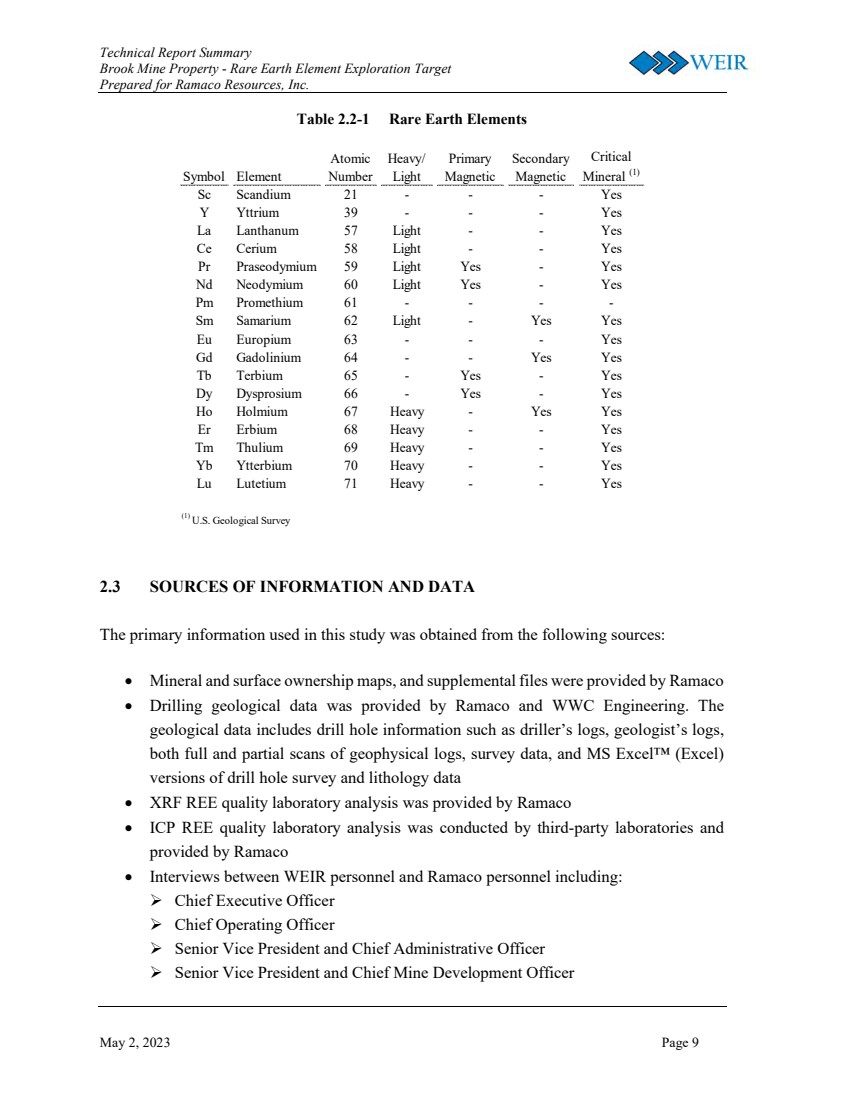
| · | In both a separate press release, and letter to shareholders, the Company reported independent findings from Weir International, Inc. (“Weir”) that its fee owned Brook Mine in Sheridan, Wyoming possesses a significant unconventional deposit of Rare Earth Elements (“REEs”) with cores exhibiting high relative concentrations of heavy REEs (“HREE”) as well as lighter REEs. These HREEs with permanent magnetic properties include Terbium (“Tb”) and Dysprosium (“Dy”). The lighter REEs with magnetic properties include Neodymium (“Nd”) and Praseodymium (“Pr”). We of course recognize that any new mine project, especially one involving emerging technology, is fraught with uncertainty. There is much technical and related work to do before we can determine the commercial feasibility of REE extraction at the Brook Mine. |
| · | The first section at the Berwind No. 1 mine has ramped production in-line with expectations since the Company began mining in March following the July 2022 ignition event. The Board of Directors recently approved advancing production in the second section of the Berwind mine to mid-2023 from 2024. Capital expenditures for this section should total approximately $3 million and it should add ~300,000 tons of incremental annualized production by late 2023. |
| · | Initial surface production recently began at the new Maben low volatile coal mine. The Company also anticipates the imminent startup of its Elk Creek preparation plant expansion project. This is expected to increase processing capacity at Elk Creek from 2 million to 3 million tons per year. |
| · | 2023 production guidance is increased from 3.0 – 3.5 million tons to 3.1 – 3.6 million tons, following strong first quarter results. 2023 sales guidance is increased from 3.2 – 3.7 million tons to 3.3 – 3.8 million tons, representing a 45% increase versus 2022 sales. |
| · | Second quarter of 2023 sales are expected to increase modestly versus first quarter of 2023 levels of 757,000 tons. By the second half of 2023, the Company expects to ramp production and sales to a run-rate of roughly 1 million tons per quarter. |
| · | U.S. metallurgical coal spot pricing is currently down almost 25% from first quarter of 2023 averages on the back of renewed global economic concerns. If indices remain at current levels for the duration of the second quarter, we anticipate our second quarter average realized pricing for company produced coal, excluding transportation charges, to fall roughly 9 – 11% from first quarter levels of $185/ton. |
MANAGEMENT COMMENTARY
Randall Atkins, Ramaco Resources’ Chairman and Chief Executive Officer commented, “Earlier this year I said that our goal in 2023 is simply to execute. After a number of operational setbacks in 2022, as well as ongoing transportation challenges, I am pleased to say that this quarter we executed better than we had expected.
In the first quarter, we achieved both record production of 834,000 tons and record sales of 757,000 tons. In addition, despite continued inflationary pressures, our non-GAAP cash cost of sales, which excludes transportation and idle mine costs, fell from $114 per ton in the fourth quarter of 2022 to $105 per ton in the first quarter of 2023. Elk Creek cash costs declined over 10% sequentially to $90 per ton in the first quarter. We also look forward to the second half production ramp at Berwind helping our overall cash mine costs to decline over the balance of the year.
Our sales team continues to aggressively increase our global footprint. After our inaugural sale to India earlier in the year, I am pleased to report that we have recently added sales to two new countries: Japan and Indonesia. Overall, the Company now has 2.7 million tons contracted, or 81% of forecasted 2023 production. Of this contracted production, 1.9 million tons have been sold at an average fixed price of $197 per ton, with the balance being export sales priced against a floating index.
While overall pricing has fallen on the back of global economic concerns, Ramaco is continuing to focus on what we can control. In terms of our continued commitment to responsibly growing production, I am pleased to note that the first section at the Berwind No. 1 mine restarted early and has been ramping production in-line with expectations. The Board recently approved pulling forward the second section of the Berwind mine to mid-2023 from 2024, which should both add ~300,000 tons of additional production on an annualized basis by late 2023 and continue to reduce overall mine costs. We also add two more milestones this quarter: the first production from our new mine at Maben and a 50% increase of Elk Creek’s preparation plant capacity from 2 to 3 million tons on an annualized basis.
Importantly, I would urge you to all read both our separate press release, as well as my letter to shareholders regarding the potentially transformative work we have been doing at our Brook Mine in Sheridan, Wyoming, to assess what may be among the most promising Rare Earth Element (“REE”) deposits on a worldwide basis. An independent assessment of the deposit has been conducted in conjunction with our reserve engineers at Weir International and the National Energy Technology Laboratory (“NETL”). Our initial conclusion is that the mine may contain one of the largest unconventional deposits of REEs discovered in the United States. Core analysis performed to date shows high relative concentrations of heavy REEs such as Terbium and Dysprosium, as well as lighter REEs with magnetic properties such as Neodymium and Praseodymium.
We of course recognize that any new mine project, especially one involving emerging technology, is fraught with uncertainty. However, given the magnitude of what we have discovered to date, we intend to pursue a thoughtful investigation of this unique opportunity. If that diligence continues on its present course perhaps Ramaco can transform its footprint into becoming both a low cost supplier of strategic REE critical materials from Wyoming as well as continuing as a producer of metallurgical coal in Central Appalachia. We intend to supply regular updates as this REE project unfolds.
Finally, as we said before, our goal for 2023 remains to execute on our objectives which are:
| · | To both increase our met coal production and processing capacity and reduce costs. |
| · | To continue to assess our potential REE deposit, with minimal initial capital outlay. |
| · | To pay down the majority of our remaining debt in order to maintain our strong balance sheet. |
| · | To pursue our dual longer-term objectives of combining an increase in profitable production with a steady growth in return of capital to our shareholders.” |
Key operational and financial metrics are presented below:
| Key Metrics | 1Q23 | 4Q22 | Change | 1Q22 | Change | |||||||||||||||
| Total Tons Sold ('000) | 757 | 675 | 12 | % | 583 | 30 | % | |||||||||||||
| Revenue ($mm) | $ | 166.4 | $ | 135.2 | 23 | % | $ | 154.9 | 7 | % | ||||||||||
| Cost of Sales ($mm) | $ | 110.5 | $ | 95.4 | 16 | % | $ | 81.3 | 36 | % | ||||||||||
| Non-GAAP Pricing of Company Produced Tons ($/Ton) | $ | 185 | $ | 182 | 2 | % | $ | 234 | (21 | )% | ||||||||||
| Non-GAAP Cash Cost of Sales - Company Produced ($/Ton)* | $ | 105 | $ | 114 | (8 | )% | $ | 106 | (1 | )% | ||||||||||
| Non-GAAP Cash Margins on Company Produced ($/Ton) | $ | 80 | $ | 68 | 18 | % | $ | 128 | (38 | )% | ||||||||||
| Net Income ($mm) | $ | 25.3 | $ | 14.4 | 76 | % | $ | 41.5 | (39 | )% | ||||||||||
| Diluted Earnings per Share | $ | 0.57 | $ | 0.32 | 75 | % | $ | 0.92 | (39 | )% | ||||||||||
| Adjusted EBITDA ($mm) | $ | 48.3 | $ | 31.9 | 51 | % | $ | 64.1 | (25 | )% | ||||||||||
| Capex ($mm) | $ | 23.5 | $ | 31.6 | (26 | )% | $ | 19.7 | 19 | % | ||||||||||
| Adjusted EBITDA less Capex ($ mm) | $ | 24.7 | $ | 0.3 | 7985 | % | $ | 44.3 | (44 | )% |
* Adjusted to include the royalty savings from the Ramaco Coal transaction for 1Q22. Excludes Berwind idle costs in 1Q23 and 4Q22.
FIRST QUARTER 2023 PERFORMANCE
In the following paragraphs, all references to “quarterly” periods or to “the quarter” refer to the first quarter of 2023, unless specified otherwise.
Year over Year Quarterly Comparison
Overall production in the quarter was 834,000 tons, up 25% from the same period of 2022. The Elk Creek complex produced 611,000 tons. Production from the Berwind and Knox Creek Mining complexes increased from 163,000 tons in the first quarter of 2022 to 223,000 tons this quarter. Overall total sales were a quarterly record of 757,000 tons, up from 583,000 tons in the first quarter of 2022. We saw a meaningful improvement in transportation service in the first quarter, and we applaud the efforts of our railroad partners.
Cash margins on Company produced coal were $80 per ton during the quarter, down 38% from the same period of 2022, based on non-GAAP revenue (FOB mine) and non-GAAP cash cost of sales. Quarterly pricing was $185 per ton of Company produced coal sold, which was 21% lower compared to the first quarter of 2022.
Company produced cash mine costs excluding transportation and idle mine costs were $105 per ton, which was 1% lower than for the same period of 2022. Cash mine costs at Elk Creek were $90 per ton during the quarter. This compared to cash mine costs at Elk Creek of $98 per ton during the same period of 2022. Elk Creek costs are expected to stay near current levels, while overall cash costs are anticipated to move lower, especially in the second half of 2023 as the Berwind Complex ramps production.
Sequential Fourth Quarter Comparison
Overall production of 834,000 tons in the first quarter of 2023 was up 139,000 tons compared with the fourth quarter of 2022, as new mines ramped up production. Total sales volume of 757,000 tons was up 12% from the fourth quarter of 2022 level of 675,000 tons.
Cash margins on Company produced coal were $80 per ton compared to $68 per ton in the fourth quarter of 2022, based on non-GAAP revenue (FOB mine) and non-GAAP cash cost of sales. The increase in margin was mainly due to lower cash costs, with first quarter cash costs of $105 per ton on company produced coal compared to $114 per ton in the fourth quarter of 2022.
BALANCE SHEET AND LIQUIDITY
As of March 31, 2023, the Company had liquidity of $65.4 million, consisting of $36.6 million of cash plus $28.8 million of availability under our revolving credit facility. This compared to liquidity of $49.1 million as of December 31, 2022.
Compared to December 31, 2022, accounts receivable increased by $29.9 million, and inventories increased by $6.0 million. We expect a meaningful decline in inventory in the second half of 2023, on the back of both improved rail service and the 50% increase in processing capacity at the Elk Creek preparation plant.
First quarter capital expenditures totaled $23.5 million. This was a decrease of 26% versus $31.6 million for the fourth quarter of 2022. The decrease was attributable to the completion of the renovation at the Berwind complex preparation plant in the fourth quarter of 2022.
The Company’s effective quarterly tax rate was 18%, excluding discrete items. For the first quarter of 2023, we recognized income tax expense of $5.5 million, as compared with $3.1 million in the fourth quarter of 2022. While the Company anticipates an overall tax rate of 20-25% in 2023, the cash tax rate in 2023 is anticipated to be just 5-10%.
In February 2023, KeyBank, N.A. ("KeyBank") led a syndicate of five banks that increased the Company's overall revolving credit facility to $175 million. Under its terms, this consists of an aggregate revolving commitment of $125 million together with an accordion feature providing an additional $50 million which would be available upon the Company’s request and subject to the terms and conditions of the facility.
The following summarizes key sales, production and financial metrics for the periods noted:
| Three months ended | ||||||||||||
| March 31, | December 31, | March 31, | ||||||||||
| In thousands, except per ton amounts | 2023 | 2022 | 2022 | |||||||||
| Sales Volume (tons) | ||||||||||||
| Company | 727 | 643 | 573 | |||||||||
| Purchased | 29 | 32 | 10 | |||||||||
| Total | 757 | 675 | 583 | |||||||||
| Company Production (tons) | ||||||||||||
| Elk Creek Mining Complex | 611 | 537 | 503 | |||||||||
| Berwind Mining Complex (includes Knox Creek) | 223 | 158 | 163 | |||||||||
| Total | 834 | 695 | 666 | |||||||||
| Company Produced Financial Metrics (a) | ||||||||||||
| Average revenue per ton | $ | 185 | $ | 182 | $ | 234 | ||||||
| Average cash costs of coal sold* | 105 | 114 | 106 | |||||||||
| Average cash margin per ton | $ | 80 | $ | 68 | $ | 128 | ||||||
| Elk Creek Financial Metrics (a) | ||||||||||||
| Average revenue per ton | $ | 194 | $ | 193 | $ | 236 | ||||||
| Average cash costs of coal sold* | 90 | 101 | 98 | |||||||||
| Average cash margin per ton | $ | 104 | $ | 92 | $ | 138 | ||||||
| Purchased Coal Financial Metrics (a) | ||||||||||||
| Average revenue per ton | $ | 245 | $ | 152 | $ | 354 | ||||||
| Average cash costs of coal sold | 209 | 119 | 300 | |||||||||
| Average cash margin per ton | $ | 36 | $ | 33 | $ | 54 | ||||||
| Capital Expenditures | $ | 23,546 | $ | 31,628 | $ | 19,742 | ||||||
| (a) | Excludes transportation. Cash costs of coal sold are defined and reconciled under “Reconciliation of Non-GAAP Measures.” |
* Adjusted to include the royalty savings from the Ramaco Coal transaction for 1Q22. Excludes Berwind idle costs in 4Q22 and 1Q23.
FINANCIAL GUIDANCE
| Full-Year | Full-Year | |||||||
| (In thousands, except per ton amounts and percentages) | 2023 Guidance | 2022 | ||||||
| Company Production (tons) | ||||||||
| Elk Creek Mining Complex | 2,200 - 2,400 | 2,033 | ||||||
| Berwind & Knox Creek Mining Complex | 900 - 1,200 | 651 | ||||||
| Total | 3,100 - 3,600 | 2,684 | ||||||
| Sales (tons) (a) | 3,300 - 3,800 | 2,450 | ||||||
| Cash Costs Per Ton - Company Produced (b) | $ | 97 - 103 | $ | 105 | ||||
| Other | ||||||||
| Capital Expenditures (c) | $ | 65,000 - 80,000 | $ | 123,012 | ||||
| Selling, general and administrative expense (d) | $ | 34,000 - 37,000 | $ | 31,810 | ||||
| Depreciation, depletion and amortization expense | $ | 48,000 - 52,000 | $ | 41,194 | ||||
| Interest expense, net | $ | 9,000 - 10,000 | $ | 6,829 | ||||
| Effective tax rate (e) | 20 - 25% | 22% | ||||||
| Cash tax rate | 5 - 10% | 11% | ||||||
| Berwind Idle Costs | $ | 3,000 | $ | 9,474 | ||||
| (a) | 2023 guidance includes a small amount of purchased coal. |
| (b) | Adjusted to include the royalty savings from the Ramaco Coal transaction for 2022. Excludes Berwind idle costs. |
| (c) | Excludes Ramaco Coal and Maben purchase price. |
| (d) | Excludes stock-based compensation. |
| (e) | Normalized, to exclude discrete items. |
Committed 2023 Sales Volume(a)
| (In millions, except per ton amounts) | Volume | Average Price | ||||||
| North America, fixed priced | 1.2 | $ | 196 | |||||
| Seaborne, fixed priced | 0.7 | $ | 200 | |||||
| Total, fixed priced | 1.9 | $ | 197 | |||||
| Indexed priced | 0.8 | |||||||
| Total committed tons | 2.7 | |||||||
| (a) | Amounts as of March 31, 2023 and includes a small amount of purchased coal. Totals may not add due to rounding. |
ABOUT RAMACO RESOURCES
Ramaco Resources, Inc. is an operator and developer of high-quality, low-cost metallurgical coal in southern West Virginia, southwestern Virginia and southwestern Pennsylvania. Its executive offices are in Lexington, Kentucky, with operational offices in Charleston, West Virginia and Sheridan, Wyoming. The Company currently has three active mining complexes in Central Appalachia and one mine not yet in production near Sheridan, Wyoming. Contiguous to the Wyoming mine, the Company operates a research and pilot facility related to the production of advanced carbon products and materials from coal. In connection with these activities, it holds a body of roughly 50 intellectual property patents, pending applications, exclusive licensing agreements and various trademarks. News and additional information about Ramaco Resources, including filings with the Securities and Exchange Commission, are available at http://www.ramacoresources.com. For more information, contact investor relations at (859) 244-7455.
FIRST QUARTER 2023 CONFERENCE CALL
Ramaco Resources will hold its quarterly conference call and webcast at 9:00 AM Eastern Time (ET) on Thursday, May 4, 2023. An accompanying slide deck will be available at https://www.ramacoresources.com/investors-center/events-calendar/ immediately before the conference call.
To participate in the live teleconference on May 4, 2023:
Domestic Live: (800) 274-8461
International Live: (203) 518-9814
Conference ID: METCQ123
Web link: Click Here
CAUTIONARY STATEMENT REGARDING FORWARD-LOOKING STATEMENTS
Certain statements contained in this news release constitute “forward-looking statements” within the meaning of the Private Securities Litigation Reform Act of 1995. These forward-looking statements represent Ramaco Resources’ expectations or beliefs concerning guidance, future events, anticipated revenue, future demand and production levels, macroeconomic trends, the development of ongoing projects, costs and expectations regarding operating results, and it is possible that the results described in this news release will not be achieved. These forward-looking statements are subject to risks, uncertainties and other factors, many of which are outside of Ramaco Resources’ control, which could cause actual results to differ materially from the results discussed in the forward-looking statements. These factors include, without limitation, risks related to the impact of the COVID-19 global pandemic, unexpected delays in our current mine development activities, the ability to successfully ramp up production at the Berwind and Know Creek complexes, the timing of the Elk Creek preparation plant to come online, failure of our sales commitment counterparties to perform, increased government regulation of coal in the United States or internationally, the further decline of demand for coal in export markets and underperformance of the railroads, the expected benefits of the Ramaco Coal and Maben acquisitions to the Company’s shareholders, and the anticipated benefits and impacts of the Ramaco Coal and Maben acquisitions. Any forward-looking statement speaks only as of the date on which it is made, and, except as required by law, Ramaco Resources does not undertake any obligation to update or revise any forward-looking statement, whether as a result of new information, future events or otherwise. New factors emerge from time to time, and it is not possible for Ramaco Resources to predict all such factors. When considering these forward-looking statements, you should keep in mind the risk factors and other cautionary statements found in Ramaco Resources’ filings with the Securities and Exchange Commission (“SEC”), including its Annual Report on Form 10-K and Quarterly Reports on Form 10-Q. The risk factors and other factors noted in Ramaco Resources’ SEC filings could cause its actual results to differ materially from those contained in any forward-looking statement.
Ramaco Resources, Inc.
Unaudited Consolidated Statements of Operations
| Three months ended March 31, | ||||||||
| In thousands, except per share amounts | 2023 | 2022 | ||||||
| Revenue | $ | 166,360 | $ | 154,882 | ||||
| Costs and expenses | ||||||||
| Cost of sales (exclusive of items shown separately below) | 110,549 | 81,253 | ||||||
| Asset retirement obligations accretion | 350 | 235 | ||||||
| Depreciation, depletion and amortization | 11,852 | 8,680 | ||||||
| Selling, general and administrative | 11,742 | 11,824 | ||||||
| Total costs and expenses | 134,493 | 101,992 | ||||||
| Operating income | 31,867 | 52,890 | ||||||
| Other income, net | 1,247 | 366 | ||||||
| Interest expense, net | (2,309 | ) | (1,130 | ) | ||||
| Income before tax | 30,805 | 52,126 | ||||||
| Income tax expense | 5,548 | 10,655 | ||||||
| Net income | $ | 25,257 | $ | 41,471 | ||||
| Earnings per common share | ||||||||
| Basic earnings per share | $ | 0.57 | $ | 0.94 | ||||
| Diluted earnings per share | $ | 0.57 | $ | 0.92 | ||||
| Basic weighted average shares outstanding | 44,281 | 44,181 | ||||||
| Diluted weighted average shares outstanding | 44,692 | 44,908 | ||||||
Ramaco Resources, Inc.
Unaudited Consolidated Balance Sheets
| In thousands, except per-share amounts | March 31, 2023 | December 31, 2022 | ||||||
| Assets | ||||||||
| Current assets | ||||||||
| Cash and cash equivalents | $ | 36,616 | $ | 35,613 | ||||
| Accounts receivable | 71,099 | 41,174 | ||||||
| Inventories | 50,971 | 44,973 | ||||||
| Prepaid expenses and other | 19,005 | 25,729 | ||||||
| Total current assets | 177,691 | 147,489 | ||||||
| Property, plant and equipment, net | 444,075 | 429,842 | ||||||
| Financing lease right-of-use assets, net | 12,443 | 12,905 | ||||||
| Advanced coal royalties | 3,277 | 3,271 | ||||||
| Other | 3,830 | 2,832 | ||||||
| Total Assets | $ | 641,316 | $ | 596,339 | ||||
| Liabilities and Stockholders' Equity | ||||||||
| Liabilities | ||||||||
| Current liabilities | ||||||||
| Accounts payable | $ | 49,850 | $ | 34,825 | ||||
| Accrued expenses | 33,070 | 41,806 | ||||||
| Asset retirement obligations | 29 | 29 | ||||||
| Current portion of long-term debt | 29,684 | 35,639 | ||||||
| Current portion of related party debt | 30,000 | 40,000 | ||||||
| Current portion of financing lease obligations | 6,114 | 5,969 | ||||||
| Insurance financing liability | 2,415 | 4,577 | ||||||
| Total current liabilities | 151,162 | 162,845 | ||||||
| Asset retirement obligations | 29,206 | 28,856 | ||||||
| Long-term debt, net | 45,567 | 18,757 | ||||||
| Long-term financing lease obligations, net | 3,980 | 4,917 | ||||||
| Senior notes, net | 32,945 | 32,830 | ||||||
| Deferred tax liability, net | 37,791 | 35,637 | ||||||
| Other long-term liabilities | 3,742 | 3,299 | ||||||
| Total liabilities | 304,393 | 287,141 | ||||||
| Commitments and contingencies | — | — | ||||||
| Stockholders' Equity | ||||||||
| Preferred stock, $0.01 par value | — | — | ||||||
| Common stock, $0.01 par value | 444 | 442 | ||||||
| Additional paid-in capital | 171,531 | 168,711 | ||||||
| Retained earnings | 164,948 | 140,045 | ||||||
| Total stockholders' equity | 336,923 | 309,198 | ||||||
| Total Liabilities and Stockholders' Equity | $ | 641,316 | $ | 596,339 | ||||
Ramaco Resources, Inc.
Unaudited Statement of Cash Flows
| Three months ended March 31, | ||||||||
| In thousands | 2023 | 2022 | ||||||
| Cash flows from operating activities | ||||||||
| Net income | $ | 25,257 | $ | 41,471 | ||||
| Adjustments to reconcile net income to net cash from operating activities: | ||||||||
| Accretion of asset retirement obligations | 350 | 235 | ||||||
| Depreciation, depletion and amortization | 11,852 | 8,680 | ||||||
| Amortization of debt issuance costs | 149 | 121 | ||||||
| Stock-based compensation | 2,937 | 1,887 | ||||||
| Deferred income taxes | 2,154 | 5,015 | ||||||
| Changes in operating assets and liabilities: | ||||||||
| Accounts receivable | (29,925 | ) | (3,194 | ) | ||||
| Prepaid expenses and other current assets | 4,779 | 1,807 | ||||||
| Inventories | (5,998 | ) | (3,752 | ) | ||||
| Other assets and liabilities | (823 | ) | (591 | ) | ||||
| Accounts payable | 13,902 | 18,653 | ||||||
| Accrued expenses | (3,272 | ) | 7,037 | |||||
| Net cash from operating activities | 21,362 | 77,369 | ||||||
| Cash flow from investing activities: | ||||||||
| Purchases of property, plant and equipment | (23,546 | ) | (19,742 | ) | ||||
| Maben acquisition bond recovery | 1,182 | — | ||||||
| Net cash from investing activities | (22,364 | ) | (19,742 | ) | ||||
| Cash flows from financing activities | ||||||||
| Proceeds from borrowings | 45,000 | 1,337 | ||||||
| Payments of dividends | (5,556 | ) | (4,998 | ) | ||||
| Repayment of borrowings | (24,145 | ) | (2,519 | ) | ||||
| Repayment of Ramaco Coal acquisition financing - related party | (10,000 | ) | — | |||||
| Repayments of financed insurance payable | (1,433 | ) | (105 | ) | ||||
| Repayments of financing leased equipment | (1,746 | ) | (1,635 | ) | ||||
| Shares surrendered for withholding taxes payable | (115 | ) | — | |||||
| Net cash from financing activities | 2,005 | (7,920 | ) | |||||
| Net change in cash and cash equivalents and restricted cash | 1,003 | 49,707 | ||||||
| Cash and cash equivalents and restricted cash, beginning of period | 36,473 | 22,806 | ||||||
| Cash and cash equivalents and restricted cash, end of period | $ | 37,476 | $ | 72,513 | ||||
Reconciliation of Non-GAAP Measures
Adjusted EBITDA
Adjusted EBITDA is used as a supplemental non-GAAP financial measure by management and external users of our financial statements, such as industry analysts, investors, lenders and rating agencies. We believe Adjusted EBITDA is useful because it allows us to more effectively evaluate our operating performance.
We define Adjusted EBITDA as net income plus net interest expense; equity-based compensation; depreciation, depletion, and amortization expenses; income taxes; certain non-operating expenses (charitable contributions), and accretion of asset retirement obligations. Its most comparable GAAP measure is net income. A reconciliation of net income to Adjusted EBITDA is included below. Adjusted EBITDA is not intended to serve as a substitute for GAAP measures of performance and may not be comparable to similarly-titled measures presented by other companies.
| (In thousands) | Q1 2023 | Q4 2022 | Q1 2022 | |||||||||
| Reconciliation of Net Income to Adjusted EBITDA | ||||||||||||
| Net income | $ | 25,257 | $ | 14,386 | $ | 41,471 | ||||||
| Depreciation, depletion and amortization | 11,852 | 11,296 | 8,680 | |||||||||
| Interest expense, net | 2,309 | 1,506 | 1,130 | |||||||||
| Income tax expense | 5,548 | 3,085 | 10,655 | |||||||||
| EBITDA | 44,966 | 30,273 | 61,936 | |||||||||
| Stock-based compensation | 2,937 | 2,031 | 1,887 | |||||||||
| Accretion of asset retirement obligations | 350 | (370 | ) | 235 | ||||||||
| Adjusted EBITDA | $ | 48,253 | $ | 31,934 | $ | 64,058 | ||||||
Non-GAAP revenue and cash cost per ton
Non-GAAP revenue per ton (FOB mine) is calculated as coal sales revenue less transportation costs, divided by tons sold. Non-GAAP cash cost per ton sold is calculated as cash cost of coal sales less transportation costs and idle mine costs, divided by tons sold. We believe revenue per ton (FOB mine) and cash cost per ton provides useful information to investors as these enable investors to compare revenue per ton and cash cost per ton for the Company against similar measures made by other publicly-traded coal companies and more effectively monitor changes in coal prices and costs from period to period excluding the impact of transportation costs, which are beyond our control. The adjustments made to arrive at these measures are significant in understanding and assessing the Company’s financial performance. Revenue per ton sold (FOB mine) and cash cost per ton are not measures of financial performance in accordance with GAAP and therefore should not be considered as a substitute to revenue and cost of sales under GAAP. The tables below show how we calculate non-GAAP revenue and cash cost per ton:
Non-GAAP revenue per ton
| Three months ended March 31, 2023 | Three months ended March 31, 2022 | |||||||||||||||||||||||
| Company | Purchased | Company | Purchased | |||||||||||||||||||||
| (In thousands, except per ton amounts) | Produced | Coal | Total | Produced | Coal | Total | ||||||||||||||||||
| Revenue | $ | 158,959 | $ | 7,401 | $ | 166,360 | $ | 150,929 | $ | 3,953 | $ | 154,882 | ||||||||||||
| Less: Adjustments to reconcile to Non-GAAP revenue (FOB mine) | ||||||||||||||||||||||||
| Transportation costs | (24,270 | ) | (176 | ) | (24,446 | ) | (17,131 | ) | (239 | ) | (17,370 | ) | ||||||||||||
| Non-GAAP revenue (FOB mine) | $ | 134,689 | $ | 7,225 | $ | 141,914 | $ | 133,798 | $ | 3,714 | $ | 137,512 | ||||||||||||
| Tons sold | 727 | 29 | 757 | 573 | 10 | 583 | ||||||||||||||||||
| Revenue per ton sold (FOB mine) | $ | 185 | $ | 245 | $ | 188 | $ | 234 | $ | 354 | $ | 236 | ||||||||||||
| Three months ended December 31, 2022 | ||||||||||||
| Company | Purchased | |||||||||||
| (In thousands, except per ton amounts) | Produced | Coal | Total | |||||||||
| Revenue | $ | 129,772 | $ | 5,455 | $ | 135,227 | ||||||
| Less: Adjustments to reconcile to Non-GAAP revenue (FOB mine) | ||||||||||||
| Transportation costs | (12,550 | ) | (574 | ) | (13,124 | ) | ||||||
| Non-GAAP revenue (FOB mine) | $ | 117,222 | $ | 4,881 | $ | 122,103 | ||||||
| Tons sold | 643 | 32 | 675 | |||||||||
| Revenue per ton sold (FOB mine) | $ | 182 | $ | 152 | $ | 181 | ||||||
Non-GAAP cash cost per ton
| Three months ended March 31, 2023 | Three months ended March 31, 2022 | |||||||||||||||||||||||
| Company | Purchased | Company | Purchased | |||||||||||||||||||||
| (In thousands, except per ton amounts) | Produced | Coal | Total | Produced | Coal | Total | ||||||||||||||||||
| Cost of sales | $ | 104,246 | $ | 6,303 | $ | 110,549 | $ | 77,863 | $ | 3,390 | $ | 81,253 | ||||||||||||
| Less: Adjustments to reconcile to Non-GAAP cash cost of sales | ||||||||||||||||||||||||
| Transportation costs | (24,347 | ) | (134 | ) | (24,481 | ) | (17,134 | ) | (239 | ) | (17,373 | ) | ||||||||||||
| Idle mine costs | (2,559 | ) | — | (2,559 | ) | — | — | — | ||||||||||||||||
| Non-GAAP cash cost of sales | $ | 77,340 | $ | 6,169 | $ | 83,509 | $ | 60,729 | $ | 3,151 | $ | 63,880 | ||||||||||||
| Tons sold | 727 | 29 | 757 | 573 | 10 | 583 | ||||||||||||||||||
| Cash cost per ton sold | $ | 105 | $ | 209 | $ | 110 | $ | 106 | $ | 300 | $ | 110 | ||||||||||||
| Three months ended December 31, 2022 | ||||||||||||
| Company | Purchased | |||||||||||
| (In thousands, except per ton amounts) | Produced | Coal | Total | |||||||||
| Cost of sales | $ | 91,014 | $ | 4,416 | $ | 95,430 | ||||||
| Less: Adjustments to reconcile to Non-GAAP cash cost of sales | ||||||||||||
| Transportation costs | (12,551 | ) | (574 | ) | (13,125 | ) | ||||||
| Idle mine costs | (4,437 | ) | — | (4,437 | ) | |||||||
| Non-GAAP cash cost of sales | $ | 74,026 | $ | 3,842 | $ | 77,868 | ||||||
| Tons sold | 643 | 32 | 675 | |||||||||
| Cash cost per ton sold | $ | 114 | $ | 119 | $ | 115 | ||||||
We do not provide reconciliations of our outlook for cash cost per ton to cost of sales in reliance on the unreasonable efforts exception provided for under Item 10(e)(1)(i)(B) of Regulation S-K. We are unable, without unreasonable efforts, to forecast certain items required to develop the meaningful comparable GAAP cost of sales. These items typically include non-cash asset retirement obligation accretion expenses, mine idling expenses and other non-recurring indirect mining expenses that are difficult to predict in advance in order to include a GAAP estimate.
# # #
Exhibit 99.2
MAJOR DEPOSITS OF MAGNETIC RARE EARTH ELEMENTS DISCOVERED AT RAMACO RESOURCES MINE IN WYOMING
MINE MAY BE UNITED STATES LARGEST UNCONVENTIONAL DEPOSIT OF REE ELEMENTS CONSIDERED VITAL TO NATION’S STRATEGIC DEFENSE AND ENERGY TRANSITION
May 3, 2023
FOR IMMEDIATE RELEASE
SHERIDAN, WY. — In association with researchers from the Department of Energy’s National Energy Technology Laboratory (“NETL”) and analysts at mining consultancy Weir International, metallurgical coal producer Ramaco Resources, Inc. (“Ramaco”-NASDAQ: METC) today released an independent Exploration Target report with technical assessment of rare earth elements (“REE”) found at its Brook Mine in Wyoming.
Following eighteen months of extensive core drilling and independent chemical analysis, NETL researchers and Ramaco now believe that the Brook Mine property contains perhaps the largest unconventional deposit of REEs discovered in the United States.
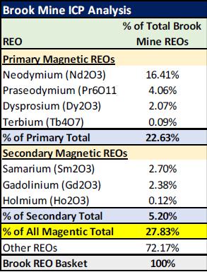
In particular, the mine ranks among the highest relative concentrations yet discovered of magnetic REEs (“MREE”) such as “heavy” REEs Terbium and Dysprosium, as well as lighter REEs such as Neodymium and Praseodymium. Initial estimates are that approximately 28% of deposit concentrations may be in the form of MREEs.
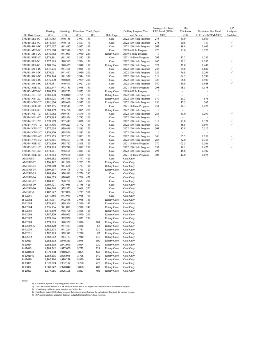
NETL analysis shows that core samples from the Brook Mine represent highly promising, world-class MREE and HREE accumulations. These deposits contain these valuable REEs on par with conventional REE deposits, but with much less of the low-value lanthanum and cerium that must be removed by separations. Based on this data, the Brook Mine could rank among the more promising deposits on a worldwide basis, including Chinese HREE deposits.
A copy of Weir International’s Exploration Target report and a shareholder letter on the discovery from Ramaco CEO and Chairman Randall Atkins can be found at www.ramacoresources.com. Exhibits from the report are also included in this release.
There is currently only one active mine for magnetic REEs in the United States, located near the Mojave Desert in California. Magnetic REE materials are used in electric vehicle motors, advanced military technology, medical devices, and much more.
The Brook Mine comprises over 15,800 acres outside of Sheridan, Wyoming, one of the largest privately controlled mineral reserves in the Western United States. Roughly 4,500 acres were permitted for mining in 2020, which is where the initial assessment program has been conducted. Mining at the Brook Mine could begin as early as the fourth quarter of 2023, following additional mining development and assessment. The additional 11,300 acres will be also assessed and could provide opportunity to increase the scale of the overall development in the future.
China currently produces the vast majority of REEs, which are increasingly important in defense, industrial, and consumer technologies. Congress and the Department of Energy have earmarked billions of dollars toward this goal, and a bipartisan bill introduced earlier this year would establish tax credits to support the production of magnetic REEs like those found at the Brook Mine.
The majority of REE deposits outside of China are associated with “conventional” mines and found in igneous hard rock deposits, which makes them both difficult and expensive to mine and process. In contrast, the REEs from the Brook Mine are characterized as “unconventional” because they are largely found in clay strata located above and below the coal seams themselves. It is expected they can be mined using normal surface mining techniques and processed in a more economic and environmental manner than conventional REE mines.
“The coal seams can contain significant quantity of REEs, making the coal seams an attractive source for these valuable minerals on an ash-basis,” said a report from Weir International. “The REEs are believed to have been incorporated into the coal during its formation and are found in association with clay minerals and organic matter in the coal seams. Interburden between the coal seams also contain elevated levels of REEs, primarily in clays, carbonaceous clays and siltstones and not necessarily associated to the coal seams.… Ramaco’s sample collection, preparation, security, and testing protocols are well documented and suffice to provide consistent, reliable, and verifiable data.”
Ramaco plans to analyze the appropriate mining, processing and mineral development plan for the REEs, along with a comprehensive economic analysis. Ramaco’s Board of Directors has authorized continued assessment of this opportunity, and additional testing results will be released periodically.
“We view this as an exciting and perhaps transformative new direction for our company,” said Ramaco CEO and Chairman Randall Atkins. “We will approach the potential to develop critical minerals with the same conservative capital expenditure and development discipline that we have applied to our core metallurgical coal business. We are also well positioned to allocate initial capital to begin a step-by-step development program.
“We of course recognize that any new mine project, especially one involving emerging technology, is fraught with uncertainty,” said Atkins. “There is much work to do, before we can determine the commercial feasibility of REE extraction at the Brook Mine. But we will evaluate the overall business proposition of developing these REE critical minerals to their highest value proposition to Ramaco, and frankly also to the country.”
“If additional diligence continues to confirm the opportunity, then Ramaco can expand its national footprint into becoming both a low-cost supplier of strategic REE critical materials from Wyoming, as well as continuing as a producer of metallurgical coal in Central Appalachia,” said Atkins. “We will supply periodic updates as this REE project unfolds.”
TECHNICAL HIGHLIGHTS
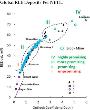
| • | Weir estimates a range of between 181,000 and 226,000 tons of magnetic rare earth oxide ("REO") at the Brook Mine site. |
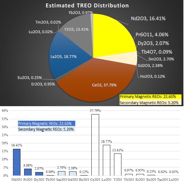
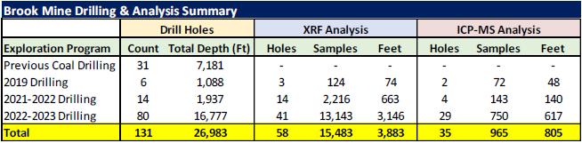
| • | A total of 131 core holes targeting the REE mineralization have been drilled to date, with 58 of the core holes having been scanned using x-ray fluorescence. An analysis of 965 test samples have been conducted using inductively coupled plasma (“ICP”) spectroscopy of the elemental composition of different cores, which tests form the basis of analysis by Weir International. |
| • | The results from ICP scan observations show an average of 28% percent overall concentration of both the four primary magnetic REEs as well as other magnetic concentrations. |
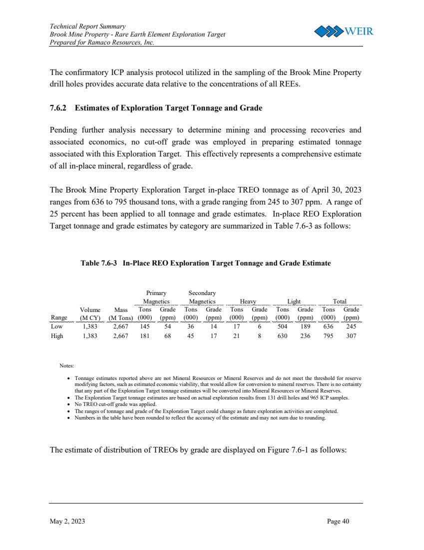
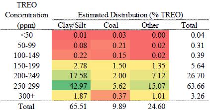
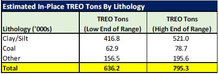
| • | The current exploration target encompasses a range between roughly 636,000 and 795,000 in place tons of 100% total rare earth oxide ("TREO") with all concentration grades. Core drilling and chemical test analysis will continue on an ongoing basis to further delineate the deposit. |
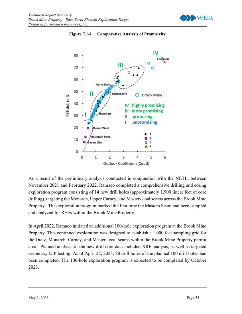
| • | As shown in Exhibit 1 below, the Brook Mine samples plot in the highest quartile relative to other REE ore bodies worldwide, with promisivity of the Brook Mine REE deposits falling along the promising to highly promising spectrum for the full range of REEs, including the four highly valued REEs with magnetic properties. |
About Ramaco Resources, Inc.
Ramaco Resources, Inc. is an operator and developer of high-quality, low-cost metallurgical coal in southern West Virginia, southwestern Virginia and southwestern Pennsylvania. Its executive offices are in Lexington, Kentucky, with operational offices in Charleston, West Virginia and Sheridan, Wyoming. The Company currently has three active mining complexes in Central Appalachia.
About Ramaco Carbon
Ramaco Carbon, a subsidiary of Ramaco Resources, Inc., is a carbon technology company based in Sheridan, Wyoming. It is pioneering more valuable and environmental uses for coal, primarily as a feedstock in the creation of advanced carbon products and materials such as rare earth elements, carbon fibers, graphene, and graphite. In addition to research partnerships with top laboratories, it operates a research and pilot facility related to the production of advanced carbon products and materials from coal in Wyoming, and holds a body of intellectual property patents, pending applications, exclusive licensing agreements and various trademarks. Ramaco Carbon has also been involved in the exploration of critical minerals from coal and related formations.
Ramaco Media Contact: press@ramacometc.com
Ramaco Investor Contact: info@ramacometc.com
Exhibit 1:
Global REE Deposits Per NETL:
Source: NETL
Exhibit 2:
In-Place REO Exploration Target Tonnage and Grade Estimate
Source: Weir International, Inc.
Exhibit 3:
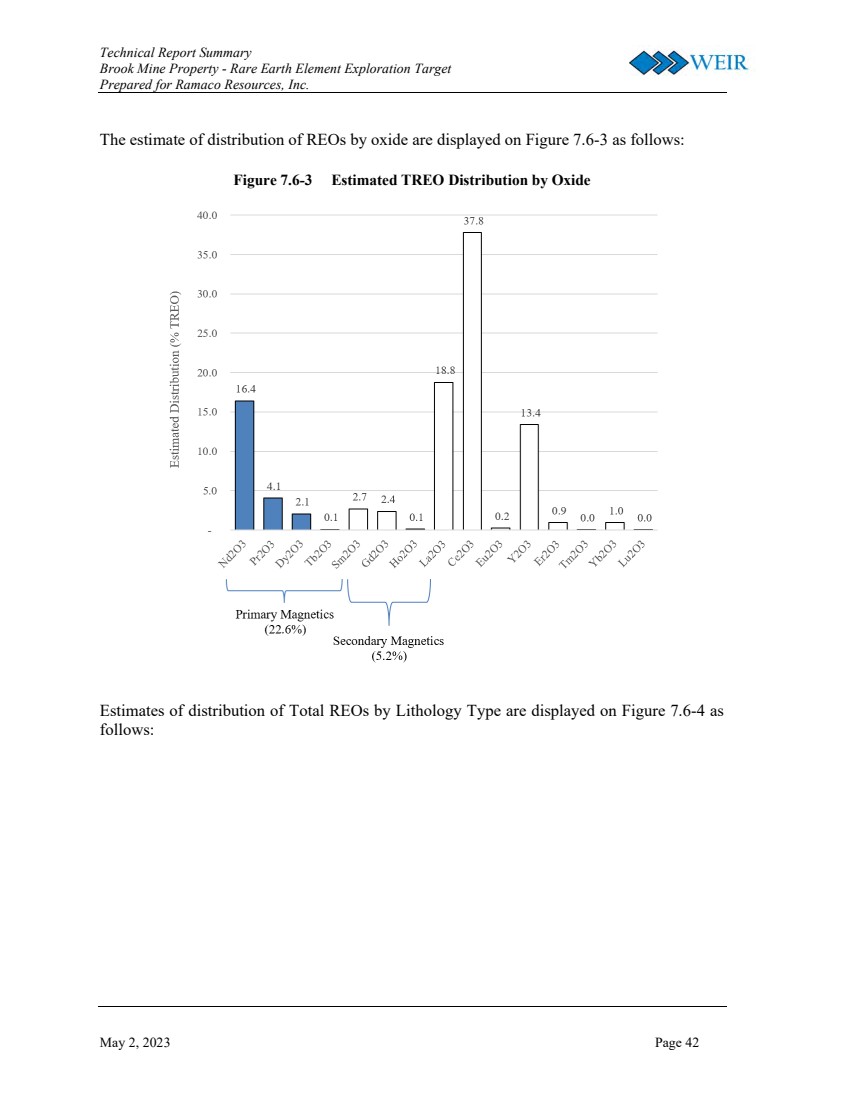
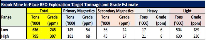
Estimated Brook Mine TREO Distribution by Oxide
Source: Weir International, Inc.
Exhibit 4:
Brook Mine ICP Analysis of REOs
Source: Weir International, Inc.
Exhibit 5:
Brook Mine Drilling & Analysis Summary
Source: Weir International, Inc.
Exhibit 6:
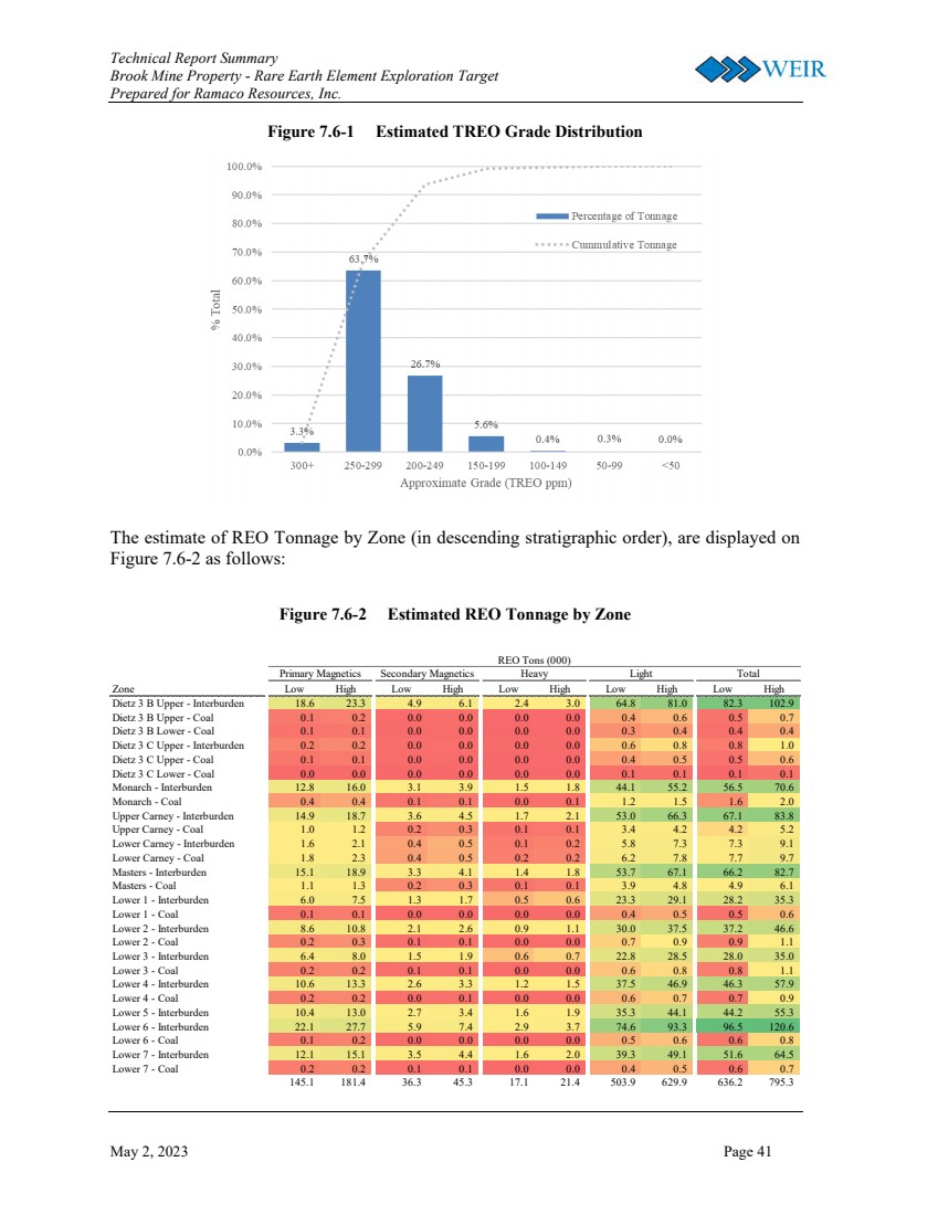
Estimated TREO Grade Distribution
Source: Weir International, Inc.
Exhibit 7:
Brook Mine Estimated TREO Concentration & Distribution (%)
Source: Weir International, Inc.
Exhibit 8:
In Place TREO Tons ('000s)
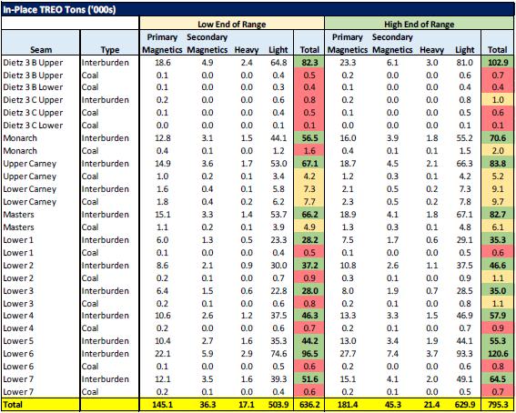
Source: Weir International, Inc.
Exhibit 9:
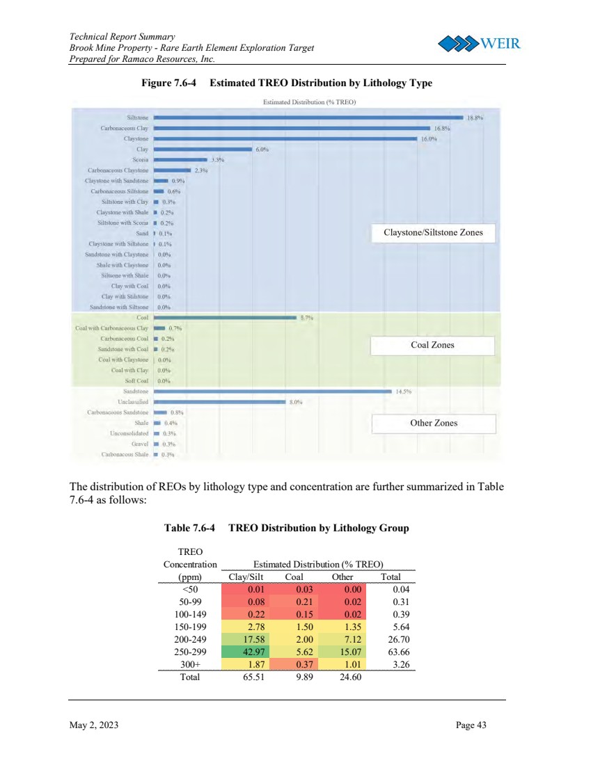
Brook Mine Estimated In-Place TREO Tons By Lithology
Source: Weir International, Inc.
Exhibit 10:
Current Brook Mine Drilling Program
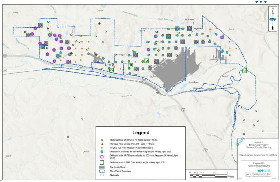
Source: Weir International, Inc.
Exhibit 11:
Current Brook Mine Overall Area of Control
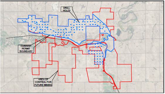
Source: WWC Engineering
CAUTIONARY STATEMENT REGARDING FORWARD-LOOKING STATEMENTS
Certain statements contained in this news release constitute “forward-looking statements” within the meaning of the Private Securities Litigation Reform Act of 1995. These forward-looking statements represent Ramaco Resources’ expectations or beliefs concerning guidance, future events, anticipated revenue, future demand and production levels, macroeconomic trends, the development of ongoing projects, costs and expectations regarding operating results, and it is possible that the results described in this news release will not be achieved. These forward-looking statements are subject to risks, uncertainties and other factors, many of which are outside of Ramaco Resources’ control, which could cause actual results to differ materially from the results discussed in the forward-looking statements. These factors include, without limitation, risks related to the timing of the mining discussed in this release and the Company's ability to successfully pursue such mining. Any forward-looking statement speaks only as of the date on which it is made, and, except as required by law, Ramaco Resources does not undertake any obligation to update or revise any forward-looking statement, whether as a result of new information, future events or otherwise. New factors emerge from time to time, and it is not possible for Ramaco Resources to predict all such factors. When considering these forward-looking statements, you should keep in mind the risk factors and other cautionary statements found in Ramaco Resources’ filings with the Securities and Exchange Commission (“SEC”), including its Annual Report on Form 10-K and Quarterly Reports on Form 10-Q. The risk factors and other factors noted in Ramaco Resources’ SEC filings could cause its actual results to differ materially from those contained in any forward-looking statement.
Exhibit 99.3

May 3, 2023
Dear Shareholders,
I try not to write shareholder letters unless there is something interesting to impart. Today there is.
To cut to the chase, over the past several years we have been working to determine a geological assessment of the rare earth element (“REE”) potential of our fee-owned Brook Mine near Sheridan, Wyoming. We explored this first under our research partnership with the Department of Energy’s National Energy Technology Laboratory (“NETL”) and more recently also with our independent reserve geologist, Weir International, Inc. (“Weir”).
Based upon extensive and on-going core drilling and independent chemical analysis, NETL and Ramaco now believe that the Brook Mine contains the largest unconventional deposit of REEs discovered to date in the United States. It has also been determined to hold meaningful amounts of valuable individual REEs with magnetic properties, the most important being neodymium and praseodymium as well as heavier HREEs such as terbium and dysprosium. Indeed, the mine may also be one of the most significant deposits of magnetic REEs discovered in the United States.
Weir estimates from initial testing shows the Brook Mine site contains a range of approximately 640,000-800,000 tons of in place 100% TREO (total rare earth oxide) with no cutoff in concentration. Of these totals, a range of between 181,000 and 226,000 tons or roughly 28% are magnetic REEs. The reserves are also low in any form of radioactive materials such as thorium. The deposits are found at reasonably shallow depths primarily in softer clay and related strata above and below our coal seams.
These current observations are made from an assessment of 4,500 acres, less than one third of the total 15,800-acre area of the Brook Mine. That area however is already permitted, and mining could be fast tracked to be initiated later this year. More drilling and testing will continue to determine the ultimate size and character of the REE opportunity over the entire area, including the property that has not yet been assessed.
An additional 11,300 contiguous acres can be permitted in the future to potentially both increase and scale the size of the opportunity. We believe that the coals and intervening clay like strata layers contained within this additional unpermitted acreage were geologically deposited in similar ways as those contained within the current permit boundary.
We are attaching to this letter an Exploration Target report independently prepared by Weir which sets forth the geological and chemical findings determined to date along with additional background detail. Weir’s technical report can also be found on our website at www.ramacoresources.com.
There is a line from the play Hamilton that “It’s nice to have Washington on your side.” As background, several years ago, as part of our research partnership with NETL we provided them older drill coring from the Brook Mine as part of their national assessment program on REEs. After their testing and analysis, NETL informed us that our property might contain meaningful concentrations of REEs. As a result, over the past 18 months we have been engaged in an extensive core drilling and chemical analysis program to further assess the resource and reserve definition of the REEs and to collect samples for on-going metallurgical testing.
We are now evaluating the overall business proposition of developing these critical minerals to their highest value proposition to Ramaco, and frankly also to the country. Ramaco’s Board has authorized the continued further quantitative and qualitative assessment on both the REE deposits and various processing and refining techniques working alongside NETL. Ramaco will provide quarterly updates on our progress from both an assessment and development perspective.
We of course recognize that any new mine project, especially one involving emerging technology, is fraught with uncertainty. There is much work to do before we can determine the ultimate commercial feasibility of REE extraction at the Brook Mine.
However, if that assessment proves up the viability of the project, we view this as an important new direction for Ramaco and an opportunity for transition. We could ultimately combine the mining and development of valuable critical and strategic REE minerals in the West, with our current core business of metallurgical coal production in Appalachia.
We would approach this unique new activity with the same conservative capital expenditure and development discipline that we have applied to our metallurgical coal business. Because of growing cash flow generation from our portfolio of metallurgical coal production, we are well positioned to allocate initial capital to begin a step-by-step development program. It is our current thinking that the ultimate overall project development would be financed incrementally from internal cash flow.
The majority of REE deposits outside of China are associated with “conventional” mines and found in igneous hard rock deposits, which makes them both difficult and expensive to mine and process. The geological analysis to date confirms that the Brook Mine’s “unconventional” REE deposits are found primarily in clay, claystone, carbonaceous shale and siltstone strata located above and below our coal seams. These are relatively shallow deposits found in softer organic material. It is therefore expected they can be mined using normal surface mining techniques and processed in a more economic and environmental manner than conventional REE mines.
We have now drilled approximately 131 core holes targeting the mineralization and have conducted chemical tests on over 965 core samples from 35 distinct core holes located across the Brook Mine. This analysis was performed using portable x-ray fluorescence (“XRF”) devices on site and by independent laboratories using an analytic technique called inductively coupled plasma (“ICP”) chemical spectroscopy.
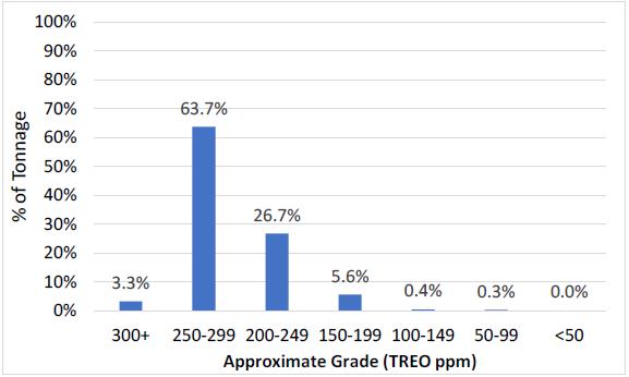
The Brook Mine has also been found to have over 90% of its distributed REE concentrations in the average of 200-300 parts per million (ppm) range spread across all acreage that has been tested, with higher concentrations of over 2,700 ppm found in isolated locations. To date, all core holes have tested positive for REE concentrations drilled across the breath of the property.
Although the amount of overall REE ppm concentrations are lower than found in “conventional” hard rock minerals, the overall level of concentrations is both consistent as well as higher than ppm concentrations usually found in other “unconventional” deposits. Indeed, in China, which possesses the world’s largest quantities of known REEs, the highest value commercial REEs are mined from unconventional ionic adsorption clay deposits. This is because the cost of mining, processing and refinement is meaningfully lower than from conventional hard minerals.
We believe the REE mineral and related strata material will be capable of being mined using traditional low-cost surface mining techniques. The general “softness” of the clay and other strata located above and below the coal seams, also means that the mined material should be able to be processed in a both substantially more economic, as well as environmental manner than “conventional” REEs. To process REEs found in hard rock minerals such as monazite, bastnaesite, xenotime requires both heavy crushing and grinding, as well as the use of highly caustic chemical and acid processing.
The cumulative cost and environmental aspects of both the processing and refinement of REEs has a critical bearing on the ultimate economic value of the deposit. This development path takes the REEs from a mineral deposit then to a concentrate, to an oxide and finally to a metal or magnet. In the case of the Brook Mine, we currently believe that processing these unconventional REEs into a concentrate may involve forms of physical separation similar to our metallurgical coal preparation plants in Appalachia and only require the use of mild solvents.
In the mining business, if one is fortunate enough to discover an unexpected mineral deposit of this unique value and dimension, it is hubris to claim that you knew what you were looking for. In our case though, perhaps we might get some credit for showing the curiosity over the past ten years that there might be more to the possible uses of coal than conventional wisdom suggests.
During that time, Ramaco, along with our partners at the National Labs such as NETL and Oak Ridge — as well as other research institutes, universities, and strategic groups — have explored the research and development of alternative uses of coal, which we like to refer to as “carbon ore”. Aside from power combustion or steel production, we have felt that carbon ore could be used as a feedstock to make higher value advanced carbon products and materials, or as a source of critical minerals.
Perhaps fate loves irony. We have often used the phrase, “Coal is too valuable to burn.” Coal and its contiguous strata may become a source of valuable and strategically needed rare earth elements for this country. This discovery might provide an interesting new path for a much-maligned, as well as one of our nation’s most abundant natural resources.
| All the best- | |
| Randall W. Atkins | |
| Chairman and Chief Executive Officer |
CAUTIONARY STATEMENT REGARDING FORWARD-LOOKING STATEMENTS
Certain statements contained in this letter constitute “forward-looking statements” within the meaning of the Private Securities Litigation Reform Act of 1995. These forward-looking statements represent Ramaco Resources’ expectations or beliefs concerning guidance, future events, anticipated revenue, future demand and production levels, macroeconomic trends, the development of ongoing projects, costs and expectations regarding operating results, and it is possible that the results described in this letter will not be achieved. These forward-looking statements are subject to risks, uncertainties and other factors, many of which are outside of Ramaco Resources’ control, which could cause actual results to differ materially from the results discussed in the forward-looking statements. These factors include, without limitation, risks related to the timing of the mining discussed in this letter and the Company's ability to successfully pursue such mining. Any forward-looking statement speaks only as of the date on which it is made, and, except as required by law, Ramaco Resources does not undertake any obligation to update or revise any forward-looking statement, whether as a result of new information, future events or otherwise. New factors emerge from time to time, and it is not possible for Ramaco Resources to predict all such factors. When considering these forward-looking statements, you should keep in mind the risk factors and other cautionary statements found in Ramaco Resources’ filings with the Securities and Exchange Commission (“SEC”), including its Annual Report on Form 10-K and Quarterly Reports on Form 10-Q. The risk factors and other factors noted in Ramaco Resources’ SEC filings could cause its actual results to differ materially from those contained in any forward-looking statement.
|
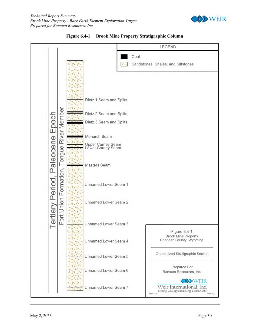
TECHNICAL REPORT SUMMARY BROOK MINE PROPERTY RARE EARTH ELEMENT EXPLORATION TARGET PREPARED FOR RAMACO RESOURCE, INC. MAY 2023 PROJECT NO. 6371.3 Mining, Geology and Energy Consultants Weir International, Inc. WEIR |
|
Technical Report Summary Brook Mine Property - Rare Earth Element Exploration Target Prepared for Ramaco Resources, Inc. May 2, 2023 Page i Notice Weir International, Inc. (WEIR) was retained by Ramaco Resources, Inc. (Ramaco, NASDAQ: METC) to prepare this Technical Report Summary (TRS) related to Ramaco’s Rare Earth Element (REE) Exploration Target. This report provides a statement of Ramaco’s REE Exploration Target located within its mineral holdings at the planned Brook Mine near Sheridan, Wyoming. This TRS has been prepared in accordance with the United States Securities and Exchange Commission (SEC), Regulation S-K 1300 for Mining Property Disclosure (S-K 1300) and 17 Code of Federal Regulations (CFR) § 229.601(b)(96)(iii)(B) reporting requirements. This report was prepared for the sole use of Ramaco, and its affiliates and is effective as of April 30, 2023. This report was prepared by WEIR personnel who meet the SEC’s definition of Qualified Persons (QPs), with sufficient experience in the relevant type of mineralization and deposit under consideration in this report. In preparing this report, WEIR relied upon data, written reports and statements provided by Ramaco. WEIR has taken all appropriate steps, in its professional opinion, to ensure the information provided by Ramaco is reasonable and reliable for use in this report. The accuracy of Exploration Target estimates is, in part, a function of the quality and quantity of available data at the time this report was prepared. Estimates presented herein are considered reasonable, however, the estimates should be accepted with the understanding that with additional data and analysis subsequent to the date of this report, the estimates may necessitate revision, which may be material. Certain information to be set forth in this report may contain “forward-looking information”. These statements are not guarantees of future performance and undue reliance should not be placed on these estimates. The assumptions used to develop forward-looking information and the risks that could cause the actual results to differ materially are detailed in the body of this report. WEIR and its personnel are not affiliates of Ramaco or any other entity with ownership, royalty or other interest in the subject property of this report. WEIR hereby consents to the use of Ramaco’s REE Exploration Target estimates, as of April 30, 2023. Qualified Person: /s/ Weir International Date: May 2, 2023 Address: Weir International, Inc. 1431 Opus Place, Suite 210 Downers Grove, Illinois 60515 |
|
Technical Report Summary Brook Mine Property - Rare Earth Element Exploration Target Prepared for Ramaco Resources, Inc. May 2, 2023 Page ii TABLE OF CONTENTS Page 1.0 Executive Summary 1 1.1 Property Description 1 1.2 Geological Setting and Mineralization 3 1.3 Development and Operations 3 1.4 Exploration 3 1.5 Exploration Target Tonnage Estimate 5 1.6 Conclusions and Recommendations 6 2.0 Introduction 8 2.1 Registrant 8 2.2 Terms of Reference and Purpose 8 2.3 Sources of Information and Data 9 2.4 Details of the Personal Inspection of the Property 10 2.5 Previous Technical Report Summary 10 3.0 Property Description 11 3.1 Property Location 11 3.2 Property Area 11 3.3 Property Control 12 3.4 Mineral Control 15 3.5 Significant Property Encumbrances and Permit Status 20 3.6 Significant Property Factors and Risks 21 3.7 Royalty Interest 21 4.0 Accessibility, Climate, Local Resources, Infrastructure, and Physiography 22 4.1 Topography, Elevation, and Vegetation 22 4.2 Property Access 22 4.3 Climate and Operating Season 22 4.4 Infrastructure 23 5.0 History 24 5.1 Previous Operations 24 5.2 Previous Exploration and Development 25 6.0 Geological Setting, Mineralization, and Deposit 26 6.1 Regional, Local, and Property Geology 26 6.1.1 Regional Geology 26 6.1.2 Local Geology 26 6.1.3 Property Geology 27 6.2 Mineral Deposit Type 27 6.3 Geological Model 27 6.4 Stratigraphic Column and Cross Section 29 7.0 Exploration 33 7.1 Drilling 33 7.1.1 Planned Drilling 36 |
|
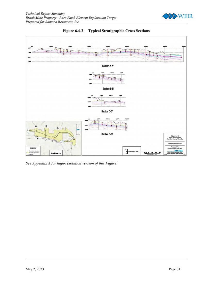
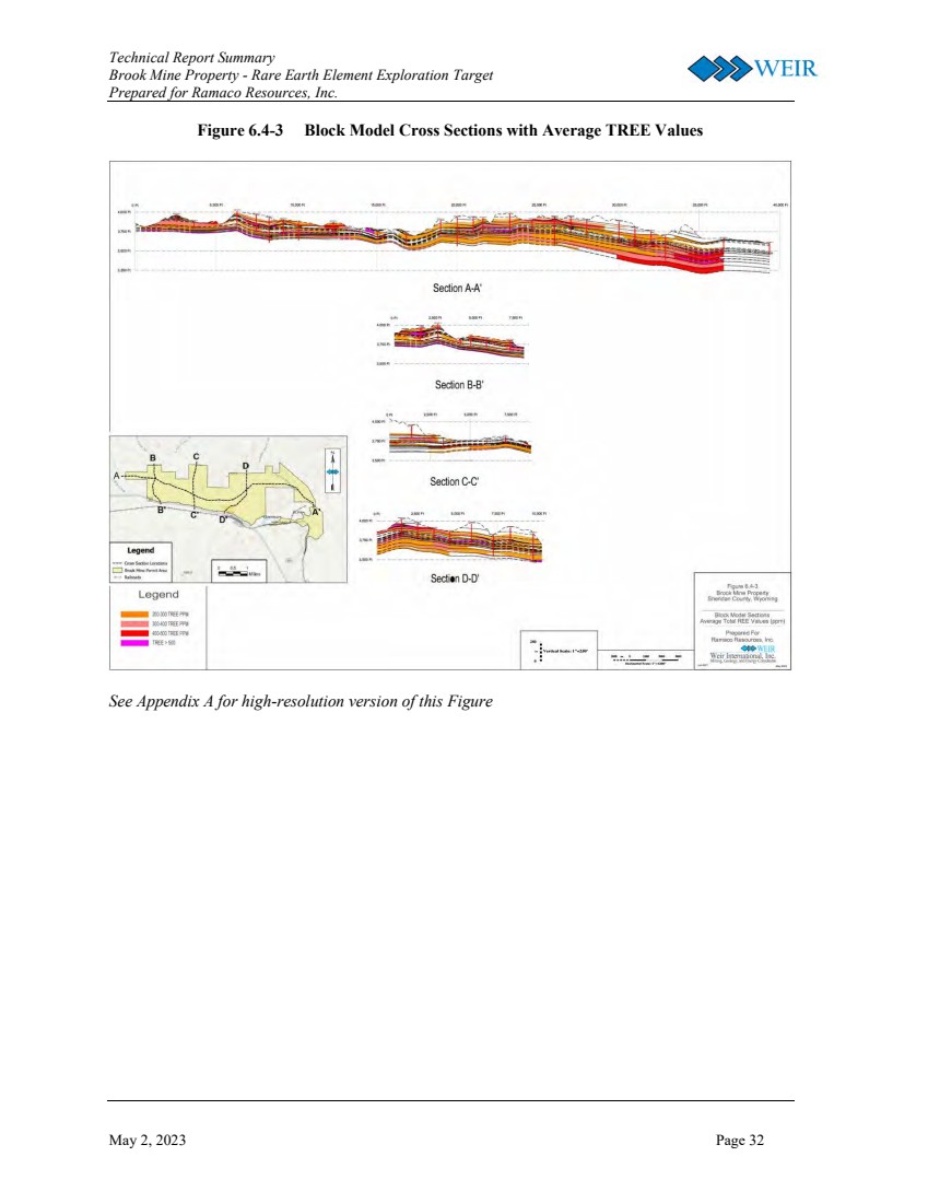
Technical Report Summary Brook Mine Property - Rare Earth Element Exploration Target Prepared for Ramaco Resources, Inc. May 2, 2023 Page iii 7.0 Exploration (continued) 7.2 Non-Drilling Exploration 37 7.3 Hydrogeological Data 37 7.4 Geotechnical Data 37 7.5 Other Relevant Drilling Data 37 7.6 Exploration Target 37 7.6.1 Assumptions, Parameters, and Methods 38 7.6.2 Estimates of Exploration Target Tonnage and Grade 40 7.6.3 Uncertainty in Estimates of Tonnage 44 7.7 Additional Commodities or Mineral Equivalent 46 8.0 Sample Preparation, Analyses, and Security 47 8.1 Sample Preparation Methods, Analysis, and Quality Control 47 9.0 Data Verification 51 9.1 Data Verification Procedures 51 9.2 Data Verification Limitations 52 9.3 Adequacy of Data 52 10.0 Mineral Processing and Metallurgical Testing 54 11.0 Mineral Resource Estimates 55 12.0 Mineral Reserve Estimates 56 13.0 Mining Methods 57 14.0 Processing and Recovery Methods 58 15.0 Infrastructure 59 16.0 Market Studies 60 17.0 Environmental Studies, Permitting, and Local Individuals or Groups Agreements 61 18.0 Capital and Operating Costs 62 19.0 Economic Analysis 63 20.0 Adjacent Properties 64 21.0 Other Relevant Data and Information 65 22.0 Interpretations and Conclusions 66 23.0 Recommendations 67 24.0 References 68 25.0 Reliance on Information Provided by the Registrant 69 FIGURES Figure 1.1-1 General Location Map 2 Figure 6.4-1 Brook Mine Property Stratigraphic Column 30 Figure 6.4-2 Typical Stratigraphic Cross Sections 31 Figure 6.4-3 Block Model Cross Sections with Average TREE Values 32 Figure 7.1-1 Comparative Analysis of Promisivity 34 Figure 7.1-2 Drill hole Locations 35 Figure 7.6-1 Estimated TREO Grade Distribution 41 Figure 7.6-2 Estimated REO Tonnage by Zone 41 Figure 7.6-3 Estimated TREO Distribution by Oxide 42 Figure 7.6-4 Estimated TREO Distribution by Lithology Type 43 Figure 7.6-5 Map of Exploration Target Composited TREO Grade 44 Figure 8.1-1 LaCeY versus TREE Regression Analysis 48 |
|
Technical Report Summary Brook Mine Property - Rare Earth Element Exploration Target Prepared for Ramaco Resources, Inc. May 2, 2023 Page iv TABLES Table 1.4-1 Drilling Programs 4 Table 1.5-1 Rare Earth Elements 5 Table 1.5-2 In-Place REO Exploration Target Tonnage and Grade Estimates 6 Table 2.2-1 Rare Earth Elements 9 Table 3.3-1 REE Exploration Target Property Control 13 Table 3.4-1 REE Exploration Target Mineral Control 16 Table 6.3-1 Stratigraphic Model Interpolators 28 Table 7.1-1 Drilling Programs 35 Table 7.6-1 REE to REO Conversions 38 Table 7.6-2 Rare Earth Elements 39 Table 7.6-3 In-Place REO Exploration Target Tonnage and Grade Estimate 40 Table 7.6-4 TREO Distribution by Lithology Group 43 Table 8.1-1 ICP Testing Laboratories 49 Table 8.1-2 ICP Assay Reporting Limits 50 Table 25.1 Information Relied Upon from Registrant 69 APPENDIX Appendix A REE Exploration Target, Geological Cross Sections Appendix B Drill Hole Database |
|
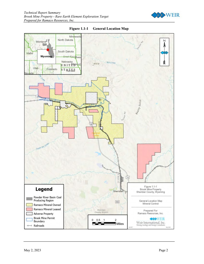
Technical Report Summary Brook Mine Property - Rare Earth Element Exploration Target Prepared for Ramaco Resources, Inc. May 2, 2023 Page 1 1.0 EXECUTIVE SUMMARY WEIR was retained by Ramaco Resources, Inc. (Ramaco) to prepare a Technical Report Summary (TRS) related to Ramaco’s Rare Earth Element (REE) Exploration Target. This report has been prepared in accordance with the United States Securities and Exchange Commission (SEC), Regulation S-K 1300 for Mining Property Disclosure (S-K 1300) and 17 Code of Federal Regulations (CFR) § 229.601(b)(96)(iii)(B) reporting requirements. 1.1 PROPERTY DESCRIPTION The REE Exploration Target is located within Ramaco’s mineral holdings at its planned Brook Mine Property located approximately seven miles north of Sheridan, Wyoming in Sheridan County. The Burlington Northern Railroad and Interstate 90 are located along the southern boundary of the current Brook Mine permit area. The Brook Mine Property is situated in the Sheridan Coal Field in the northwestern portion of the Powder River Basin (PRB) coal producing region of the of the United States (see Figure 1.1-1). The United States Geological Survey (USGS) 7.5-minute quadrangle maps are Acme, Hultz Draw, Monarch, and Sheridan. The Brook Mine Property consists of approximately 15,800 acres of Ramaco owned and leased mineral holdings located in Sheridan County, Wyoming. Ramaco acquired the Brook Mine Property in 2011 from the Sheridan-Wyoming Coal Company. When Ramaco began development of the Brook Mine Property as a thermal coal resource in 2012, Ramaco originally permitted approximately 4,600 acres that it regarded as the optimal area for a new surface coal mine. As Ramaco began further core drilling exploration in 2021 and 2022 relative to REE exploration, Ramaco decided to continue to drill in areas within the original permit boundary in order to leverage the existing drilling core available for sampling. As such, the REE Exploration Target is limited to the current permit boundary of the Brook Mine Property. Ramaco has indicated its intention to proceed with additional drilling and assessment of additional areas of the Brook Mine Property to assess the potential for expanding its REE Exploration Target beyond the current permit boundary. |
|
Technical Report Summary Brook Mine Property - Rare Earth Element Exploration Target Prepared for Ramaco Resources, Inc. May 2, 2023 Page 2 Figure 1.1-1 General Location Map |
|
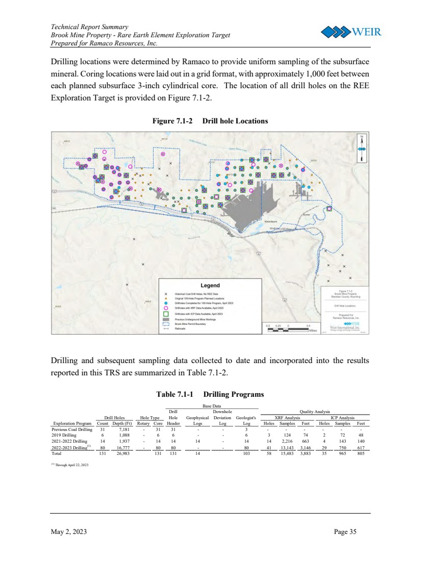
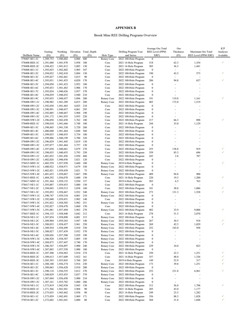
Technical Report Summary Brook Mine Property - Rare Earth Element Exploration Target Prepared for Ramaco Resources, Inc. May 2, 2023 Page 3 1.2 GEOLOGICAL SETTING AND MINERALIZATION The Sheridan Coal Field is within the northwestern portion of the PRB. The regional geology of this area is characterized by a sequence of sedimentary rocks that formed during the Late Cretaceous to early Paleocene Period. The stratigraphic sequence consists of interbedded sandstones, mudstones, and coal seams that were deposited in fluvial, deltaic, and lacustrine environments. The primary coal seams that may be associated with REEs on the Brook Mine Property, in descending stratigraphic order, are the Dietz 1, Dietz 2, Dietz 3, Monarch, Upper Carney, Lower Carney, and Masters. There are also seven unnamed minor coal seams below the Masters Seam. The REEs are believed to have been incorporated into the coal during its formation and are found in association with clay minerals and organic matter in the coal seams. Interburden between the coal seams also contain elevated levels of REEs, primarily in clays, carbonaceous clays, shales, and siltstones not necessarily associated with the coal seams. 1.3 DEVELOPMENT AND OPERATIONS The REE Exploration Target is currently in an exploration stage. The current phase of exploration drilling, sampling, and analysis is planned to be completed by October 2023. Ramaco anticipates that once the ongoing 100-hole exploration program is completed, it will continue drilling on the current area, and other areas of the Brook Mine Property (beyond the area defined in this Exploration Target). This additional exploration plan is yet to be finalized. 1.4 EXPLORATION Drilling has served as the primary form of exploration on the REE Exploration Target area. A Total of 131 drill holes have served to define the Exploration Target. This drilling data consists of 31 coal exploration drill holes, drilled by a previous property owner, as well as 100 holes drilled by Ramaco. A geological model was built using all 131 exploration drill holes. Approximately 121 of these drill holes are within the currently permitted REE Exploration Target area. |
|
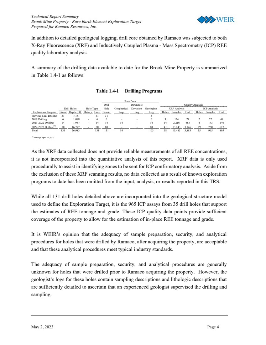
Technical Report Summary Brook Mine Property - Rare Earth Element Exploration Target Prepared for Ramaco Resources, Inc. May 2, 2023 Page 4 In addition to detailed geological logging, drill core obtained by Ramaco was subjected to both X-Ray Fluorescence (XRF) and Inductively Coupled Plasma - Mass Spectrometry (ICP) REE quality laboratory analysis. A summary of the drilling data available to date for the Brook Mine Property is summarized in Table 1.4-1 as follows: Table 1.4-1 Drilling Programs As the XRF data collected does not provide reliable measurements of all REE concentrations, it is not incorporated into the quantitative analysis of this report. XRF data is only used procedurally to assist in identifying zones to be sent for ICP confirmatory analysis. Aside from the exclusion of these XRF scanning results, no data collected as a result of known exploration programs to date has been omitted from the input, analysis, or results reported in this TRS. While all 131 drill holes detailed above are incorporated into the geological structure model used to define the Exploration Target, it is the 965 ICP assays from 35 drill holes that support the estimates of REE tonnage and grade. These ICP quality data points provide sufficient coverage of the property to allow for the estimation of in-place REE tonnage and grade. It is WEIR’s opinion that the adequacy of sample preparation, security, and analytical procedures for holes that were drilled by Ramaco, after acquiring the property, are acceptable and that these analytical procedures meet typical industry standards. The adequacy of sample preparation, security, and analytical procedures are generally unknown for holes that were drilled prior to Ramaco acquiring the property. However, the geologist’s logs for these holes contain sampling descriptions and lithologic descriptions that are sufficiently detailed to ascertain that an experienced geologist supervised the drilling and sampling. Drill Downhole Hole Geophysical Deviation Geologist's Exploration Program Count Depth (Ft) Rotary Core Header Logs Log Log Holes Samples Feet Holes Samples Feet Previous Coal Drilling 31 7,181 - 31 31 - - 3 - - - - - - 2019 Drilling 6 1,088 - 6 6 - - 6 3 124 74 2 72 48 2021-2022 Drilling 14 1,937 - 14 14 14 - 14 14 2,216 663 4 143 140 2022-2023 Drilling(1) 80 16,777 - 80 80 - - 80 41 13,143 3,146 29 750 617 Total 131 26,983 131 131 14 103 58 15,483 3,883 35 965 805 (1) Through April 22, 2023 Drill Holes XRF Analysis ICP Analysis Quality Analysis Base Data Hole Type |
|
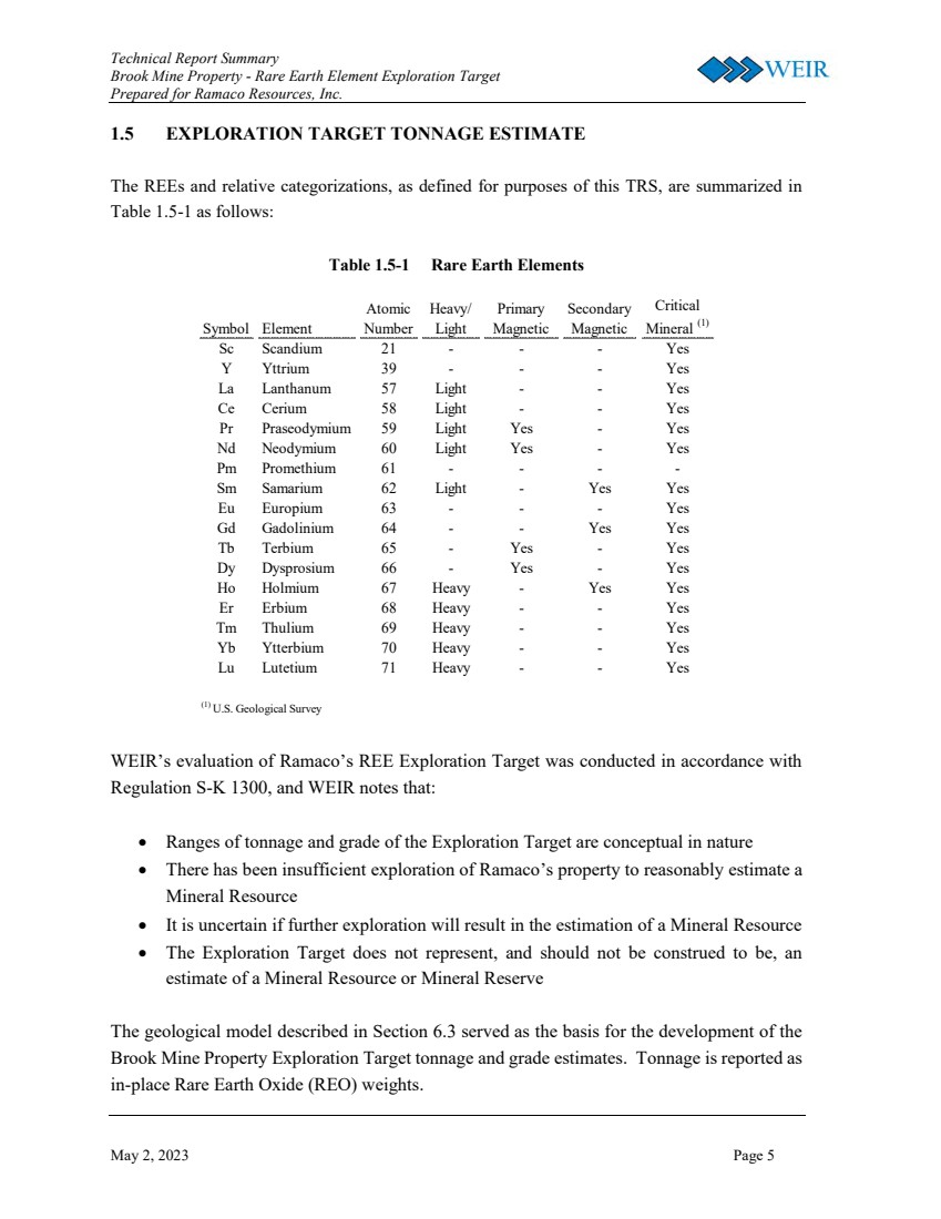
Technical Report Summary Brook Mine Property - Rare Earth Element Exploration Target Prepared for Ramaco Resources, Inc. May 2, 2023 Page 5 1.5 EXPLORATION TARGET TONNAGE ESTIMATE The REEs and relative categorizations, as defined for purposes of this TRS, are summarized in Table 1.5-1 as follows: Table 1.5-1 Rare Earth Elements Symbol Element Atomic Number Heavy/ Light Primary Magnetic Secondary Magnetic Critical Mineral (1) Sc Scandium 21 - - - Yes Y Yttrium 39 - - - Yes La Lanthanum 57 Light - - Yes Ce Cerium 58 Light - - Yes Pr Praseodymium 59 Light Yes - Yes Nd Neodymium 60 Light Yes - Yes Pm Promethium 61 - - - - Sm Samarium 62 Light - Yes Yes Eu Europium 63 - - - Yes Gd Gadolinium 64 - - Yes Yes Tb Terbium 65 - Yes - Yes Dy Dysprosium 66 - Yes - Yes Ho Holmium 67 Heavy - Yes Yes Er Erbium 68 Heavy - - Yes Tm Thulium 69 Heavy - - Yes Yb Ytterbium 70 Heavy - - Yes Lu Lutetium 71 Heavy - - Yes (1) U.S. Geological Survey WEIR’s evaluation of Ramaco’s REE Exploration Target was conducted in accordance with Regulation S-K 1300, and WEIR notes that: • Ranges of tonnage and grade of the Exploration Target are conceptual in nature • There has been insufficient exploration of Ramaco’s property to reasonably estimate a Mineral Resource • It is uncertain if further exploration will result in the estimation of a Mineral Resource • The Exploration Target does not represent, and should not be construed to be, an estimate of a Mineral Resource or Mineral Reserve The geological model described in Section 6.3 served as the basis for the development of the Brook Mine Property Exploration Target tonnage and grade estimates. Tonnage is reported as in-place Rare Earth Oxide (REO) weights. |
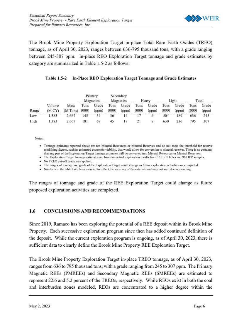
|
Technical Report Summary Brook Mine Property - Rare Earth Element Exploration Target Prepared for Ramaco Resources, Inc. May 2, 2023 Page 6 The Brook Mine Property Exploration Target in-place Total Rare Earth Oxides (TREO) tonnage, as of April 30, 2023, ranges between 636-795 thousand tons, with a grade ranging between 245-307 ppm. In-place REO Exploration Target tonnage and grade estimates by category are summarized in Table 1.5-2 as follows: Table 1.5-2 In-Place REO Exploration Target Tonnage and Grade Estimates Notes: • Tonnage estimates reported above are not Mineral Resources or Mineral Reserves and do not meet the threshold for reserve modifying factors, such as estimated economic viability, that would allow for conversion to mineral reserves. There is no certainty that any part of the Exploration Target tonnage estimates will be converted into Mineral Resources or Mineral Reserves. • The Exploration Target tonnage estimates are based on actual exploration results from 131 drill holes and 965 ICP samples. • No TREO cut-off grade was applied. • The ranges of tonnage and grade of the Exploration Target could change as future exploration activities are completed. • Numbers in the table have been rounded to reflect the accuracy of the estimate and may not sum due to rounding. The ranges of tonnage and grade of the REE Exploration Target could change as future proposed exploration activities are completed. 1.6 CONCLUSIONS AND RECOMMENDATIONS Since 2019, Ramaco has been exploring the potential of a REE deposit within its Brook Mine Property. Each successive exploration program since then has added continued definition of the deposit. While the current exploration program is ongoing, as of April 30, 2023, there is sufficient data to clearly define the Brook Mine Property REE Exploration Target. The Brook Mine Property Exploration Target in-place TREO tonnage, as of April 30, 2023, ranges from 636 to 795 thousand tons, with a grade ranging from 245 to 307 ppm. The Primary Magnetic REEs (PMREEs) and Secondary Magnetic REEs (SMREEs) are estimated to represent 22.6 and 5.2 percent of the TREOs, respectively. While REOs exist in both the coal and interburden zones modeled, REOs are concentrated to a higher degree within the Range Tons (000) Grade (ppm) Tons (000) Grade (ppm) Tons (000) Grade (ppm) Tons (000) Grade (ppm) Tons (000) Grade (ppm) Low 1,383 2,667 145 54 36 14 17 6 504 189 636 245 High 1,383 2,667 181 68 45 17 21 8 630 236 795 307 Primary Magnetics Secondary Magnetics Heavy Light Total Volume (M CY) Mass (M Tons) |
|
Technical Report Summary Brook Mine Property - Rare Earth Element Exploration Target Prepared for Ramaco Resources, Inc. May 2, 2023 Page 7 interburdens, with over 65 percent of the estimated REO tonnage located within clay and siltstone formations. Ramaco’s sample collection, preparation, security, and testing protocols are well documented and suffice to provide consistent, reliable, and verifiable data. These protocols should be maintained throughout the continued exploration program and any subsequent extensions of the current exploration program. As with any exploration state mineral mining project, there are risks and uncertainties associated with TREO tonnage and grade estimates. While existing drill hole density provides strong confidence in structural modeling, continued ICP testing will necessarily fill-in existing gaps in the modeling of REO concentrations. Regardless of the care taken in defining this Exploration Target, tonnage estimates reported throughout this TRS are not Mineral Resources or Mineral Reserves and do not meet the threshold for reserve modifying factors that would allow for conversion to Mineral Reserves. There is no certainty that any part of the Exploration Target tonnage estimates will be converted into Mineral Resources or Mineral Reserves. |
|
Technical Report Summary Brook Mine Property - Rare Earth Element Exploration Target Prepared for Ramaco Resources, Inc. May 2, 2023 Page 8 2.0 INTRODUCTION 2.1 REGISTRANT WEIR was retained by Ramaco (Nasdaq: METC) to prepare a TRS related to Ramaco’s REE Exploration Target. The REE Exploration Target is located within Ramaco’s mineral holdings at its planned Brook Mine Property located approximately seven miles north of Sheridan, Wyoming. 2.2 TERMS OF REFERENCE AND PURPOSE This TRS was prepared specifically for Ramaco’s REE Exploration Target. The tonnages within the REE Exploration Target have been classified in accordance with SEC mining property disclosure rules under Subpart 1300 and Item 601 (96)(B)(iii) of Regulation S-K. Unless otherwise stated, all quantities, qualities, distances, and currencies are expressed in United States customary units. Despite the presence of coal within the Brook Mine Property, this TRS does not report estimates of coal tonnage or quality associated with Ramaco’s coal mineral holdings. Under Regulation S-K 1300, an Exploration Target is defined as a statement or estimate of the exploration potential of a mineral deposit in a defined geological setting where the statement or estimate, quoted as a range of tonnage and a range of grade (or quality), relates to mineralization for which there has been insufficient exploration to estimate a Mineral Resource. REEs are comprised of a group of 17 chemically similar elements that include the Lanthanoids (atomic numbers 57-71), and Scandium and Yttrium. These elements are critical in the manufacturing of advanced materials, and development of new technologies supporting the United States’ infrastructure, defense, and energy needs. REEs are typically found in bedrock and regolith-hosted geologic ore deposits. Domestic coal deposits have also been identified as promising sources of REE and other critical minerals. The REEs and relative categorizations, as defined for purposes of this TRS, are summarized in Table 2.2-1 as follows: |
|
Technical Report Summary Brook Mine Property - Rare Earth Element Exploration Target Prepared for Ramaco Resources, Inc. May 2, 2023 Page 9 Table 2.2-1 Rare Earth Elements Symbol Element Atomic Number Heavy/ Light Primary Magnetic Secondary Magnetic Critical Mineral (1) Sc Scandium 21 - - - Yes Y Yttrium 39 - - - Yes La Lanthanum 57 Light - - Yes Ce Cerium 58 Light - - Yes Pr Praseodymium 59 Light Yes - Yes Nd Neodymium 60 Light Yes - Yes Pm Promethium 61 - - - - Sm Samarium 62 Light - Yes Yes Eu Europium 63 - - - Yes Gd Gadolinium 64 - - Yes Yes Tb Terbium 65 - Yes - Yes Dy Dysprosium 66 - Yes - Yes Ho Holmium 67 Heavy - Yes Yes Er Erbium 68 Heavy - - Yes Tm Thulium 69 Heavy - - Yes Yb Ytterbium 70 Heavy - - Yes Lu Lutetium 71 Heavy - - Yes (1) U.S. Geological Survey 2.3 SOURCES OF INFORMATION AND DATA The primary information used in this study was obtained from the following sources: • Mineral and surface ownership maps, and supplemental files were provided by Ramaco • Drilling geological data was provided by Ramaco and WWC Engineering. The geological data includes drill hole information such as driller’s logs, geologist’s logs, both full and partial scans of geophysical logs, survey data, and MS Excel™ (Excel) versions of drill hole survey and lithology data • XRF REE quality laboratory analysis was provided by Ramaco • ICP REE quality laboratory analysis was conducted by third-party laboratories and provided by Ramaco • Interviews between WEIR personnel and Ramaco personnel including: ➢ Chief Executive Officer ➢ Chief Operating Officer ➢ Senior Vice President and Chief Administrative Officer ➢ Senior Vice President and Chief Mine Development Officer |
|
Technical Report Summary Brook Mine Property - Rare Earth Element Exploration Target Prepared for Ramaco Resources, Inc. May 2, 2023 Page 10 ➢ Director of Development for Carbon Products ➢ Director of Life Sciences ➢ Manager of Laboratory Technologies ➢ Laboratory Technician ➢ Contract Geologist ➢ Contract Driller A detailed list of all data received and reviewed for this study is provided in Sections 24.0 and 25.0 of this TRS. 2.4 DETAILS OF THE PERSONAL INSPECTION OF THE PROPERTY WEIR personnel did not conduct a site visit to the Brook Mine Property. At this early stage of exploration, WEIR relied on photographs and other documentation of on-site procedures. WEIR reviewed photographs of each phase of the exploration process including drilling, core logging, core preservation, sample preparation, and sample testing. Further, between January and April 2023, WEIR participated in weekly video conferences with Ramaco personnel and its third-party consultants regarding progress on drilling, on-site scanning, sample preparation, third-party laboratory testing, and other site work, planning, and logistics. 2.5 PREVIOUS TECHNICAL REPORT SUMMARY This TRS is an initial disclosure of an REE Exploration Target for the Brook Mine Property. |
|
Technical Report Summary Brook Mine Property - Rare Earth Element Exploration Target Prepared for Ramaco Resources, Inc. May 2, 2023 Page 11 3.0 PROPERTY DESCRIPTION 3.1 PROPERTY LOCATION The REE Exploration Target is located within Ramaco’s mineral holdings at its Brook Mine Property, located approximately seven miles north of Sheridan, Wyoming in Sheridan County. The Burlington Northern Railroad and Interstate 90 are located along the southern boundary of the current Brook Mine permit area. The REE Exploration Target and the Brook Mine Property are situated in the Sheridan Coal Field in the northwestern portion of the PRB coal producing region of the of the United States (see Figure 1.1-1). The USGS 7.5-minute quadrangle map sheets are Acme, Hultz Draw, Monarch, and Sheridan, and the property lies within Townships 56 and 57 North, Ranges 84 and 85 West. 3.2 PROPERTY AREA The Brook Mine Property consists of over 15,800 acres of Ramaco owned and leased mineral holdings located in Sheridan County, Wyoming. Ramaco acquired the Brook Mine Property in 2011 from the Sheridan-Wyoming Coal Company. When Ramaco began development of the Brook Mine Property as a thermal coal resource in 2012, Ramaco originally permitted approximately 4,600 acres that it regarded as the optimal area for a new surface coal mine. As Ramaco began further core drilling exploration in 2021 and 2022 relative to REE exploration, Ramaco decided to continue to drill in areas within the original permit boundary in order to leverage the existing drilling core available for sampling. As such, the REE Exploration Target is limited to the permit boundary of the Brook Mine Property. Ramaco has indicated its intention to proceed with additional drilling and assessment of the entire Brook Mine Property to assess the potential for expanding its REE Exploration Target beyond the current permit boundary. Ramaco’s properties and facilities in the Sheridan, Wyoming area include the Brook Mine (which is currently undeveloped), the iCAM (Innovating Carbon Advanced Materials) Center, and the iPark Center. The iCAM Center is the first integrated carbon resource, research and development, and production facility. It hosts research professionals from national laboratories, universities, private research groups, government organizations, as well as manufacturing organizations in |
|
Technical Report Summary Brook Mine Property - Rare Earth Element Exploration Target Prepared for Ramaco Resources, Inc. May 2, 2023 Page 12 laboratory, pilot-plant, and permanent operating facilities. The iCam Center promotes collaboration to achieve innovations around advanced uses for carbon. The iPark Center is intended to become a next generation mine-mouth “coal to products” manufacturing facility, with zero net emissions. Located next to the Brook Mine Property, operations at the iPark Center intend to utilize coal from the mine to create high-value carbon products. These products include carbon fiber, graphene, graphite, carbon nano tubes, carbon dots, carbon-based resins, carbon-based building products, medical products, and activated carbon. 3.3 PROPERTY CONTROL Ramaco was granted a mineral deed from the Sheridan-Wyoming Coal Company (SWCC) on August 17, 2011. SWCC had previously deeded the surface rights, as described in Table 3.3- 1, to Big Horn Coal Company on June 28, 1954 and recorded in Deed Book 98, Page 127 in the Sheridan County Courthouse. The deed grants Ramaco all coal and other minerals contained in all of the lands described in Table 3.3-1, together with the right to mine, explore, drill, extract, and remove the same. The deed also grants Ramaco the right to use surface lands, as needed, to mine, explore, drill, extract, and remove said coal and other minerals. Further, the deed grants that should Ramaco mine, drill, explore, extract, and remove coal or other minerals and utilize any part of the surface lands in connection with those activities, Ramaco will remain free from any liability or claim for damage to the surface of said lands related to subsidence or other injury to the surface of said lands resulting from such operations. Ramaco was granted a Surface Owner Consent and Surface Use Agreement from Padlock Ranch Company on September 1, 2016. The agreement provided Ramaco with surface owner consent to mining the land located in Sheridan County, Wyoming, as described in Table 3.3-1 below. Ramaco also entered an agreement with Taylor Investments, LLC (Taylor), effective August 22, 2012, that granted Ramaco the exclusive right and privilege to enter and use all the surface of the lands as may be convenient and necessary for mining the fee coal owned by Ramaco underlying the lands for a period of 20 years, as described in Table 3.3-1 (Taylor Surface Lands - Ramaco Fee Coal), as well as the exclusive right and privilege to mine, extract, and remove all of the coal deposits, and other minerals comingled therewith, in and under the lands |
|
Technical Report Summary Brook Mine Property - Rare Earth Element Exploration Target Prepared for Ramaco Resources, Inc. May 2, 2023 Page 13 described in Table 3.3-1 (Taylor Surface Lands - Taylor/Legerski Fee Coal) for a period of 20 years. Table 3.3-1 REE Exploration Target Property Control Bighorn Coal Company Surface Lands Township 57 North, Range 84 West, 6th P.M., Sheridan County, WY Section 3: SW¼SE¼, S½SW¼ Section 7: E½SE¼ Section 8: S½ Section 9: NE¼, SW¼NW¼, S½ Section 10: NE¼, SW¼NW¼ Section 14: That part of SW¼SW¼ lying south of the Tongue River Section 15: NE¼NE¼, W½NE¼, NW¼, W½SE¼, E½SE¼ south or Tongue Elver, the SW¼ excepting therefrom (i) the Acme towmsite sold to Gothard Bylund in certain Agreement for Warranty Deed and Bill of Sale dated July 15, 1953, and (ii) certain tracts of land deeded to Montana-Dakota Utilities Company, described as follows: Beginning at a point 50 feet north 26° 54' 30" west of a point which is 1984.5 feet north 31° 23' east from the southwest comer; thence south 69° 6' west 100.51 feet; thence north 26° 54' 30" west 420.82 feet; thence north 24° 54' east 127.24 feot; thence south 86° 14' west 509.5 feet; thence south 26° 55' east 363.2 feet; thence south 69° 6' west 477.6 feet to the point of beginning. Section 17: All Section 18: E½ Section 19: NE¼NE¼, All of SE¼NE¼ except the SW¼ thereof sold to William Long, also all that portion of NW¼NE¼ lying East of Tongue River Section 20: NW¼, NW¼SW¼, All NE¼ north of C. B. & Q. Railroad Company right-of-way Section 21: All except tracts and lots of Model Townsite owned by parties of record, and except that portion of SW¼NW¼ lying between the North line of the C. B. & Q. Railroad right-of-way and the North line of said SW¼NW¼, consisting of 4 acres, more or less, as conveyed to Bruno Romeo. Section 22: All Section 27: N½SE½, and the N½ except a tract of land described as .follows: Beginning 535.5 feet north 59° 30' east from the West Quarter corner of said Sec. 27; thence north 16° 12' east 200 feet; thence south 73° 48' east 200 feet; thence south 16° 12' west 200 feet; thence north 73° 48' west 200 feet to the point of beginning. Section 28: NE¼, N½SE¼ Township 57 North, Range 85 West, 6th P.M., Sheridan County, Wyoming: A certain tract in Sections 14 and 23 as described in Warranty Deed dated January 26, 1916 from George Masters to Peter Kooi, recorded in Book Z of Deeds, Page 214 County Clerk's Office Padlock Surface Lands |
|
Technical Report Summary Brook Mine Property - Rare Earth Element Exploration Target Prepared for Ramaco Resources, Inc. May 2, 2023 Page 14 Township 57 North, Range 84 West, 6th P.M., Sheridan County, WY Section 7: E½SE¼ Section 8: S½ Section 15: SE¼SW¼ Part Containing 5 acres more or less Section 17: All Section 18: E½ lying north of I-90 ROW Section 20: That portion of N½ located north of I-90 ROW and north of Acme Road ROW containing 81 acres more or less Section 21: NW¼ Part and W1/2NE¼ Part Containing 4 acres more or less Taylor Surface Lands - Taylor/Legerski Fee Coal Township 57 North, Range 85 West, 6th P.M., Sheridan County, Wyoming: Section 12: South half of the Northeast quarter, the Southeast quarter of the Northwest quarter, the Southeast quarter and the East half of the Southwest quarter. Section 13: North half of the Northeast quarter and the Northeast quarter of the Northwest quarter. Excepting that portion conveyed to The State Highway Commission of Wyoming by Warranty Deed recorded February 10, 1981 in Book 255, Page 70. Taylor Surface Lands - Ramaco Fee Coal Township 57 North, Range 84 West, 6th P.M., Sheridan County, Wyoming: Section 18: All that portion of Lot 4 (SW¼SW¼) lying north of the northerly right of way line of Interstate Highway No. 90, said northerly right of way line being of hereinafter stated distances to the left or northerly side measured at right angles or radially to the following described survey line of highway, said parallel right of way line beginning on the west boundary and ending on the east boundary of said Lot 4; beginning at a point on said west boundary from which the southwest corner of Section 18 bears S. 0° 30’ E. a distance of 862.5 feet; thence with said parallel right of way lines 270 feet to the left or northerly side, S. 81° 23.6’ E. a distance of 876.2 feet; thence with said parallel right of way line 210 feet to the left or northerly side, continuing S. 81° 23.6’ E. a distance of 455 feet, more or less, to a point on said east boundary. ALSO, NW¼, N½SW¼ and SE¼SW¼ Excepting that portion conveyed to The State of Wyoming Highway Commission of Wyoming by Warranty Deed recorded February 10,1981 in Book 255, Page 70. Township 57 North, Range 85 West, 6th P.M., Sheridan County, Wyoming: Section 11: SE¼SE¼ Section 12: SW¼SW¼ |
|
Technical Report Summary Brook Mine Property - Rare Earth Element Exploration Target Prepared for Ramaco Resources, Inc. May 2, 2023 Page 15 Section 13: NW¼NW¼, S½N½, NE¼SE¼, and also all of the SW¼ and W½SE¼, except that portion thereof lying South of U.S. Highway No. 87 (now Interstate 90); also all that portion of the SE¼SE¼ lying north of the northerly right of way line of Interstate Highway No. 90, said northerly right of way line being 270 feet to the right or northerly side when measured at right angles to the following described survey line of highway, said northerly right of way begins on the east boundary and ends on the north boundary of said SE¼SE¼; beginning at a point on said east boundary from which the southeast corner of said Section 13, bears S. 0° 30’ E, a distance of 862.5 feet; thence N. 81° 23.6’ W. a distance of 82.9 feet to the point of beginning of a 1° 00’ circular curve to the right, the radius of which is 5,729.6 feet; thence along said curve through a central angle of 10° 38.4’ a distance of 1,064.1 feet to the point of ending of said curve; thence N. 70° 45.1’ W. a distance of 45 feet, more or less, to a point on the west boundary of said SE¼SE¼ from which the northwest corner thereof bears northerly a distance of 230 feet, more or less. Excepting the right of way of the C.B. & Q. Railroad, also excepting the right of way of the Grand Island and Northern Wyoming Railroad Company as recorded July 11, 1893 in Book E, Page 253 of Deeds, and Recorded June 11,1894 in Book E, Page 427 of Deeds, Also excepting that portion conveyed to The State Highway Commission of Wyoming by Warranty Deed recorded February 10, 1981 in Book 255, Page 70. Section 14: E½NE¼, and all of the NE¼SE¼ excepting therefrom the following tract of land, to-wit: Beginning at the Southeast corner of said NE¼SE¼; thence West to the Southwest corner of said NE¼SE¼; thence North 205 feet to the South line of the County Road; thence Southeasterly along said road to the East line of said Section 14; thence South 27 feet to the point of beginning. Excepting a portion conveyed to The State Highway Commission of Wyoming by Warranty Deed recorded February 10, 1981 in Book 255, Page 70. 3.4 MINERAL CONTROL Ramaco was granted a mineral deed from SWCC on August 17, 2011. The mineral deed granted Ramaco all of Grantor’s right, title and interest in the coal and other minerals, except the oil, gas and coalbed methane for the mineral described in Table 3.4-1. Ramaco also entered an agreement with Taylor, effective August 22, 2012, that granted Ramaco the exclusive right and privilege to enter and use all the surface of the lands as may be convenient and necessary for mining the fee coal owned by Ramaco underlying the lands for a period of 20 years. Additionally, Taylor granted Ramaco the exclusive right and privilege to mine, extract, and remove all of the coal deposits, and other minerals comingled therewith, in and under the lands described in Table 3.4-1 for a period of 20 years. In addition to the SWCC and Taylor agreements, Ramaco was granted a Coal Mining Lease Agreement, effective January 7, 2014, by and between William J. Laya and Joyce J. Laya, |
|
Technical Report Summary Brook Mine Property - Rare Earth Element Exploration Target Prepared for Ramaco Resources, Inc. May 2, 2023 Page 16 Trustees of the William J. Laya Trust under Trust Agreement dated November 19, 1993, and Joyce J. Laya and William J. Laya, Trustees of the Joyce J. Laya Trust under Trust Agreement dated November 19, 1993 and Thomas C. Laya (collectively, Laya). The Laya Agreement granted Ramaco the exclusive right and privilege to mine, extract, and remove all of the coal deposits, and other minerals commingled therewith in and under the land described in Table 3.4-1 for a period of 20 years, and from year to year thereafter until all mineable and merchantable coal has been exhausted. The mineral control located in Sheridan County, Wyoming is described in Table 3.4-1. Table 3.4-1 REE Exploration Target Mineral Control Sheridan-Wyoming Coal Company Mineral Township 56 North, Range 84 West, 6th P.M., Sheridan County, Wyoming: Section 3: All that part of the NW¼ lying East of the right of way of the BNSF Railway (formerly Chicago, Burlington and Quincy Railroad); Sections 3 and 4: All that part of the West Half of the Northwest Quarter of Section 3 and East Half of the Northeast Quarter of Section 4 lying east of the center of the channel of Big Goose Creek and West of the County Road which parallels the right-of-way of the BNSF Railway (formerly Chicago, Burlington and Quincy Railroad), as more specifically described in that certain Warranty Deed recorded in Book 15, Page 202 of the Sheridan County records. Township 57 North, Range 84 West, 6th P.M., Sheridan County, Wyoming: Section 3: SW¼SE¼, S½SW¼ Section 7: E½SE¼ Section 8: S½ Section 9: NE¼, SW¼NW¼, S½ Section 10: NE¼, SW¼NW¼ Section 14: That part of SW¼SW¼ lying south of the Tongue River Section 15: NE¼NE¼, W½NE¼, NW¼, W½SE¼ and that portion of the E½SE¼ lying south of the Tongue River, the SW¼ except a tract of land lying in the N½SW¼ described as follows: Commencing at a point which is North 31°23’ East 1984.5 feet, and thence North 63°05’30” East 475 feet from the Southwest corner of said Section 15, said point being marked by a cement monument; thence North 26°54’30” West a distance of 357 feet to a point marked by a cement monument; thence running South 86°13’55” West a distance of 509.5 feet to a point marked by a cement monument; thence South 24°54’ West 26°54’30” East a distance of 420.82 feet; thence running North 69°06’ East a distance of 578.15 feet to the point of beginning, containing 5.8 acres, more or less; and ALSO EXCEPTING That portion of the NW¼SW¼ described as follows: |
|
Technical Report Summary Brook Mine Property - Rare Earth Element Exploration Target Prepared for Ramaco Resources, Inc. May 2, 2023 Page 17 Section 15 (continued): Beginning at a point which is located S. 42°40’33” E., 1,286.21 feet from the West Quarter corner of said Section 15, thence N. 59°25’31” E., 40.33 feet to a point thence S. 31°27’08” E., 70.26 feet to a point; thence S. 60°00’11” W., 39.88 feet to a point, thence N. 31°49’24” W., 69.86 feet to the point of beginning, containing .06 acres, more or less. Section 17: All Section 18: E½, NW¼, N½SW¼, SE¼SW¼ Section 19: NE¼NE¼, SE¼NE¼ and that portion of NW¼NE¼ lying East of Tongue River; S½ and all those portions of SW¼NE¼, E½NW¼ and Lot 2 South of the center of the Tongue River. Section 20: N½, N½SE¼, SE¼SE¼ Section 21: All except the Townsite of Model which lies in parts of the SW¼NW¼ and NW¼SW¼ of Section 21 and EXCEPT a four acre tract in the SW¼NW¼ lying between the North line of the BNSF Railway (formerly C. B. & Q. Railroad) Right-of-way and the North line of said SW¼NW¼, said tract being conveyed to BRUNO ROMEO. Section 22: All Section 26: S½S½ Section 27: N½S½, and the N½--except a tract of land described as follows: Beginning 535.5 feet north 59°30’ east from the West Quarter comer of said Sec. 27; thence north 16°12’ east 200 feet; thence south 73°48’ east 200 feet; thence south 16°12’ west 200 feet; thence north 73°48’ west 200 feet to the point of beginning. S½S½ except a 2 acre tract described as follows: Commencing at a point 221 feet East and 30 feet North of Southwest cornr of Section 27, thence Northerly along the West line of the BNSF Railway (formerly C. B. & Q. Railroad) right of way 378 feet to a point; thence West 241 feet to a point; thence South 378 feet to a point; thence East 221 feet to point of beginning. All that part of SW¼SW¼ Section 27 lying West of the BNSF Railway (formerly Burlington Northern Railroad) except the 2 acres above described. Section 28: NE¼, N½SE¼, SE¼SE¼ Section 29: W½W½ Section 30: All Section 33: NW¼NE¼, S½NE¼, SE¼, NE¼NE¼ Section 34: NE¼, E½NW¼, SW¼NW¼, S½ and all that portion of the NW¼NW¼ described as follows: Beginning at the Northwest corner of said Section 34, thence East along section line a distance of 220 feet to the Westerly right of way line of the BNSF Railway (formerly Chicago, Burlington and Quincy Railroad), thence Southeasterly along said right of way line on a 2° curve to the left a distance of 1,145 feet; thence West a distance of 108 feet to the East bank of Big Goose Creek; thence following the general course of Big Goose Creek as follows: North 53° West 500 feet, South 86° West 130 feet, South 29° West 327 feet. South 70° West 104 feet, North 79° West 150 feet, North 69° West 275 feet, North 36° East 1215 feet, to a point on the North line of said Section 33; thence East along said North Line a distance of 235 feet to the point of beginning, containing 19.2 acres, more or less. Section 35: All |
|
Technical Report Summary Brook Mine Property - Rare Earth Element Exploration Target Prepared for Ramaco Resources, Inc. May 2, 2023 Page 18 Township 57 North, Range 85 West, 6th P.M., Sheridan County, Wyoming: Section 11: SE¼SE¼ Section 12: SW¼SW¼ Section 13: NW¼NW¼, S½N½, N½S½, that portion of S1/2SW¼, SE¼SW¼ lying North of State Highway US 87 as at present located. That portion of SW¼SE¼, S½SW¼ lying South of State Highway US 87 as at present located. Section 14: E½NE¼, and the NE¼SE¼ except the following described tract: Beginning at the Southeast Corner of the Northeast quarter of the Southeast quarter (NE¼SE¼) of said Section 14, thence West to Southwest Corner of the Northeast quarter of the Southeast Quarter of said Section, thence North 205 feet to the South line of the County Road; Thence Southeasterly along said Road to the East line of said Section 14, thence South 27 feet to the point of beginning. Section 23: That portion of the N½NE¼, NE¼NW¼ lying South of the Tongue River, S½NE¼, SE¼NW¼, NE¼SW¼, SE¼SW¼, SE¼ Section 24: Those portions of NW¼NE¼, N½NW¼ lying South of the Tongue River; SW¼NW¼, W½SW¼, SE¼ and that portion of SE¼NE¼ lying South of the Tongue River except the three parcels described immediately above. That portion of NW¼NE¼, N½NW¼ lying North of the Tongue River. Section 25: NE¼, W½NW¼, N½SW¼ Section 26: N½, SE¼ Section 35: NW¼ Taylor Surface Lands - Taylor/Legerski Fee Coal Township 57 North, Range 85 West, 6th P.M., Sheridan County, Wyoming: Section 12: South half of the Northeast quarter, the Southeast quarter of the Northwest quarter, the Southeast quarter and the East half of the Southwest quarter. Section 13: North half of the Northeast quarter and the Northeast quarter of the Northwest quarter. Excepting that portion conveyed to The State Highway Commission of Wyoming by Warranty Deed recorded February 10, 1981 in Book 255, Page 70. Laya Leased Mineral Township 57 North, Range 85 West, 6th P.M., Sheridan County, Wyoming: Section 10: SE¼NE¼, N½S½, SE¼SE¼ W1/2SE¼, SW¼, SW¼NW¼ Section 11: W½SE¼, SW¼, SW¼NW¼ |
|
Technical Report Summary Brook Mine Property - Rare Earth Element Exploration Target Prepared for Ramaco Resources, Inc. May 2, 2023 Page 19 Section 14: W½NE¼, NW¼, and that part of the S½ described as commencing at the half section comer between Section 14 and 15, in Township 57 North, Range 85 West, 6th P.M., being the NW comer of the NW¼SW¼ of said Section 14 as the point of beginning; thence south along the section line 1,000 feet, more or less, to the north line of the right-of-way of the Grand Island & Northern Wyoming Railroad Company; thence running in a southeasterly direction along the north line of the said right-of-way to a point on the east section line of said Section 14, which said point is 408 feet, more or less, south of the NE corner of the SE¼SE¼ of said Section 14; thence running north along said section line to a point, which said point is 27 feet north of the northeast comer of the SE¼SE¼ of said Section 14; thence running in a northwesterly direction 1,336 feet to a point on the north and south dividing line between the E½ of the E½ of said Section 14, which point is 435 feet north of the line of the said right-of-way and 1,115 feet south of the northwest comer of the NE¼SE¼ of said Section 14; from said last named point running thence north along said division line 1,115 feet to the said northwest comer of the said NE¼SE¼ of said Section 14; thence running west to the point of beginning. Section 15: E½NE¼ Excepting, therefrom two (2) parcels conveyed to The State Highway Commission of Wyoming in Book 291 of Deeds at page 545, and more particularly described as follows: Parcel 1- All that portion of the SE¼NE¼ of Section 15, T57N, R85W, of the 6th P.M., Wyoming lying south of a parallel right-of-way line of hereinafter stated distances to the right or northerly side when measured at right angles or radially to the following described survey line of highway, said parallel right-of-way line begins on the east boundary and ends on the west boundary of said SE¼NE¼: Beginning at a point on the east boundary of said Section 15 from which the east quarter corner thereof bears N 0 degrees 28' 05.6" W a distance of 149.81 feet, said point of beginning also being located on a 1 degree 00' circular curve concave to the north, the radius of which is 5,729.58 feet and at which point a line tangent to said curve bears N 72 degrees 30' 36.7" W; thence with said parallel right-of-way lines 275 feet to the right or northerly side along said curve through a central angle of 5 degrees 43' 32.4" a distance of 572.57 feet; thence with said parallel right-of-way line 200 feet to the right or northerly side continuing along said curve through a central angle of 2 degrees 22' 02.6" a distance of 236.74 feet to the point of ending of said curve; thence continuing with said parallel right-of-way line 200 feet to the right or northerly side, N 64 degrees 25' 01.6" W a distance of 720 feet, more or less, until said parallel right-of-way line intersects said west boundary. Parcel 2- |
|
Technical Report Summary Brook Mine Property - Rare Earth Element Exploration Target Prepared for Ramaco Resources, Inc. May 2, 2023 Page 20 All those portions of the SW¼NW¼ of Section 14, T57N, R85W of the 6th P.M. and of a tract of land lying in the S½ of said Section 14 as described in Book 54 at page 569 of the Sheridan County Records, lying between the southerly right-of-way boundary as described in Book 102 at page 72 of the Sheridan County Records and a parallel right-of-way line of hereinafter stated distances to the left or northerly side when measured at right angles or radially to the following described survey line of highway, said parallel right-of-way line begins on the west boundary of said Section 14 and ends on the east boundary of the NW¼SE¼ of said Section 14: Commencing at a point on the west boundary of said Section 14 from which the west quarter comer thereof bears N 0 degrees 28' 05.6" W a distance of 149.81 feet; thence N 72 degrees 02' 27.0" W a distance of 93.87 feet to the True Point of Beginning. Said True Point of Beginning also being located on a 1 degree 00' circular curve concave to the north, the radius of which is 5,729.58 feet and at which point a line tangent to said curve bears S 71 degrees 34' 17.4" E; thence with said parallel right-of-way line 275 feet to the left or northerly side, southeasterly along said curve through a central angle of 4 degrees 12’ 46.9" a distance of 421.30 feet; thence with said parallel right-of-way line 175 feet to the left or northerly side continuing southeasterly along said curve through a central angle of 12 degrees 04' 09.8" a distance of 1,206,94 feet to the point of ending of said curve; thence continuing with said parallel right-of-way line 175 feet to the left or northerly side, S 87 degrees 51' 14.1" E a distance of 93.06 feet; thence with said parallel right-of-way line 200 feet to the left or northerly side continuing S 87 degrees 51' 14.1" E a distance of 800 feet; thence with said parallel right-of-way line 300 feet to the left or northerly side, continuing S 87 degrees 51’ 14.1" E a distance of 438.99 feet to the point of beginning of a 0 degrees 45' circular curve concave to the south, the radius of which is 7,639.44 feet; thence continuing with said parallel right-of-way line 300 feet to the left or northerly side, southeasterly along said curve through a central angle of 5 degrees 26' 54.8" a distance of 726.47 feet, to the point of ending of said curve; thence continuing with said parallel right-of-way line 300 feet to the left or northerly side, S 82 degrees 24’ 19.3" E a distance of 435 feet, more or less, until said southerly right-of-way boundary as described in Book 102 at page 72 intersects the east boundary of said NW¼SE¼. Note: All bearings and distances in these descriptions are based on the Wyoming State Plane Coordinate System, East Central Zone, modified to Wyoming Highway Department Coordinate System by an adjustment factor of 1.0003000. 3.5 SIGNIFICANT PROPERTY ENCUMBRANCES AND PERMIT STATUS WEIR has not discovered any significant encumbrances for any of the tracts within the REE Exploration Target area. |
|
Technical Report Summary Brook Mine Property - Rare Earth Element Exploration Target Prepared for Ramaco Resources, Inc. May 2, 2023 Page 21 Ramaco was issued Permit No. 841-T1 on July 7, 2020 by the Land Quality Division of the Wyoming Department of Environmental Quality for surface mining in Sheridan County, Wyoming. Permit No. 841-T1 consists of 4,549 acres. The permit boundary is shown on Figure 1.1-1. Ramaco was issued Air Quality Permit P0025939 on July 20, 2020 by the Air Quality Division of the Wyoming Department of Environmental Quality for the Brook Mine, as also described in Wyoming Permit No. 841-T1. 3.6 SIGNIFICANT PROPERTY FACTORS AND RISKS Given Ramaco’s controlled interests within the REE Exploration Target, which relate in part to property that is either owned by Ramaco or held by others and leased to Ramaco, WEIR assesses that there are no significant issues affecting access to the REE interests, or Ramaco’s ability to execute its mine plans. WEIR did not conduct an independent verification of property control, nor has it independently surveyed the mining locations. WEIR has relied on information compiled from maps and summaries of the owned and leased properties prepared by Ramaco. WEIR did not conduct a legal title investigation relative to Ramaco’s mineral and surface rights. Historically, property control has not posed any challenges related to Ramaco’s operations. 3.7 ROYALTY INTEREST Ramaco, at the Brook Mine Property, holds no royalty or similar interest in property that is owned or operated by another party. |
|
Technical Report Summary Brook Mine Property - Rare Earth Element Exploration Target Prepared for Ramaco Resources, Inc. May 2, 2023 Page 22 4.0 ACCESSIBILITY, CLIMATE, LOCAL RESOURCES, INFRASTRUCTURE, AND PHYSIOGRAPHY 4.1 TOPOGRAPHY, ELEVATION, AND VEGETATION The Brook Mine Property is located on the western edge of a broad plain that extends from the Bighorn Mountains to the Black Hills of South Dakota. This area is characterized by high plateaus, which have been dissected by meandering streams, leaving ridges between the main watersheds. Surface elevations range from a low of 3,600 feet above mean sea level (MSL) on the eastern edge of the property to a high of 4,080 feet above MSL in the northwest. The main drainages in the area are the eastward flowing Tongue River and Goose Creek, flowing to the north. The confluence of these drainages is near the old town of Acme in Section 22. 4.2 PROPERTY ACCESS Access to the property is from Interstate Highway 90, which crosses the property from west to south. State Highway 338, which connects Sheridan to Decker, Montana, crosses the southeastern portion of the Brook Mine permit area. Secondary roads and trails provide access to the remaining lands. Rail access is by the Burlington Northern Railroad, which is located in the Tongue River and Goose Creek valleys. The nearest airport is the Sheridan County Airport (SHR), which is located in Sheridan, Wyoming, approximately 11 miles southeast of the Brook Mine Property. The Billings Logan International Airport (BIL) in Billings, Montana, is located approximately 95 miles northwest of the Brook Mine Property. The waterways surrounding the property are not navigable for commercial traffic. 4.3 CLIMATE AND OPERATING SEASON The Brook Mine Property has a semi-arid climate with four distinct seasons. The summers are warm and dry, with temperatures ranging from the mid-80 to low 90 degrees Fahrenheit (28- 33 Celsius) in July and August. The winters are cold and snowy, with temperatures averaging 20-30 degrees Fahrenheit (-6 to -1 Celsius) in December and January. Spring and fall are transitional seasons, with cooler temperatures and occasional rain and snow. Coal mining operations in the PRB operate year-round, regardless of weather conditions. |
|
Technical Report Summary Brook Mine Property - Rare Earth Element Exploration Target Prepared for Ramaco Resources, Inc. May 2, 2023 Page 23 4.4 INFRASTRUCTURE This TRS does not address existing, planned, or required infrastructure that may relate to development of the REE Exploration Target at the Brook Mine Property. |
|
Technical Report Summary Brook Mine Property - Rare Earth Element Exploration Target Prepared for Ramaco Resources, Inc. May 2, 2023 Page 24 5.0 HISTORY 5.1 PREVIOUS OPERATIONS Much of the history of coal mining in the Sheridan Coal Field was provided in a John T. Boyd Company report, Potentially Strip Mineable Coal Reserves Contained on the Sheridan-Wyoming Coal Company Property, dated November 20, 1979 (Boyd Report). The Boyd Report indicated that underground coal mining began in the Sheridan coal field around 1894 and lasted until 1953. During this period, there were 14 deep mines in the vicinity of the Brook Mine Property. The coal was used domestically in the Sheridan area, and to supply the railroad. Most of the mines were individually owned until 1920 when the major mines, the Dietz, Acme, Model, Carney, Monarch and Kooi, were consolidated and incorporated under the Sheridan-Wyoming Coal Company, a subsidiary of United States Distributing Corporation. This corporation and the subsidiary, Sheridan-Wyoming Coal Company, merged with The Pittston Company in 1943. Information on these mines is very sparce and consists of mine maps on six of the mines, although boundaries are available on all of the mines. In March 1978, Boyd Company engineers visited the Wyoming Inspector of Mines in Rock Springs and reviewed mine maps on the Monarch Mine 45, Monarch Mine 45-2, Acme Mine 42, Hotchkiss, Model, and Armstrong mines. Bottom of seam elevations were shown for all the mines except Model and Armstrong; seam heights were available only for the Acme Mine 42. Available data indicates that the bottom 14 feet of the Monarch Seam was mined in the Monarch Mine 45-2. The maps also indicate that pillars were pulled during retreat mining; i.e., the majority of pillars in Monarch Mine 45 and Acme Mine 42, and 20 percent in Monarch Mine 45-2. Excessive subsidence of the Acme Mine 42 and Dietz No. 1 and 2 mines can be seen in aerial photographs. In 1943, Peter Kiewit Sons' Company formed a coal mining subsidiary, the Big Horn Coal Company (Big Horn). Operations commenced on a Wyoming state lease in Section 36 (T. 58N., R. 85W.), located approximately three miles north of the northwest corner of the Brook Mine Property. In 1954, Big Horn entered into a coal lease agreement with the SWCC and operations commenced in Section 22 (T. 57N., R. 84W.). From 1954 through 1969, coal production averaged about 350,000 tons per year. In 1970, coal production increased to |
|
Technical Report Summary Brook Mine Property - Rare Earth Element Exploration Target Prepared for Ramaco Resources, Inc. May 2, 2023 Page 25 approximately one million tons per year due to increased demand for western coal. Big Horn abandoned its mining operations in 2000. 5.2 PREVIOUS EXPLORATION AND DEVELOPMENT Exploration of the Brook Mine Property, prior to Ramaco’s ownership, was limited to coal exploration drilling. In total, data was available for 31 drill holes, drilled prior to 2011. The assaying of drilled core was targeted at testing thermal coal quality, including moisture, ash, sulfur, and calorific value. No sampling was conducted at the time relative to REE concentrations. WEIR has reviewed these historical drill holes and successfully correlated the holes with drilling conducted by Ramaco. |
|
Technical Report Summary Brook Mine Property - Rare Earth Element Exploration Target Prepared for Ramaco Resources, Inc. May 2, 2023 Page 26 6.0 GEOLOGICAL SETTING, MINERALIZATION, AND DEPOSIT 6.1 REGIONAL, LOCAL, AND PROPERTY GEOLOGY 6.1.1 Regional Geology The Sheridan Coal Field is within the northwestern portion of the PRB. The regional geology of this area is characterized by a sequence of sedimentary rocks that formed during the Late Cretaceous to early Paleocene Periods. The stratigraphic sequence consists of interbedded sandstones, mudstones, and coal seams that were deposited in fluvial, deltaic, and lacustrine environments. The Sheridan Coal Field is situated within the Tongue River Member of the Fort Union Formation. This formation is composed of interbedded sandstones, shales, and coals that were deposited during the Paleocene Period. The thickness of the Tongue River Member varies from 150 to 400 feet and contains several coal seams that range in thickness from 1 to 30 feet. The coal seams in the Sheridan Coal Field are classified as low-sulfur, sub-bituminous coal. These coals have a low ash content, high calorific value, and low sulfur content, making the coal ideal fuel for power generation. The coal seams are generally continuous over large areas and are flat-lying, and amenable to surface mining. The sedimentary rocks in the Sheridan Coal Field were deposited in a series of ancient rivers and lakes that once covered the area. These rivers and lakes were fed by the highlands to the west and north, and the sediment was deposited as the water slowed and lost its carrying capacity. The sandstones were deposited in the channels of the rivers, while the shales and mudstones were deposited in the floodplains and lakes. The regional geology of the Sheridan Coal Field has been influenced by tectonic activity in the region. The area has experienced several episodes of uplift and subsidence, which have created a series of fault blocks and basins. The coal seams in the Sheridan Coal Field are located in one of these basins, which has preserved the coal seams from erosion and allowed the seams to be mined. 6.1.2 Local Geology The Brook Mine Property is located on the western edge of a broad plain that extends from the Bighorn Mountains to the Black Hills of South Dakota. This area is characterized by high |
|
Technical Report Summary Brook Mine Property - Rare Earth Element Exploration Target Prepared for Ramaco Resources, Inc. May 2, 2023 Page 27 plateaus, which have been dissected by meandering streams, leaving ridges between the main watersheds. Surface elevations range from a low of 3,600 feet above MSL on the eastern edge of the property to a high of 4,080 feet above MSL in the northwest. The main drainages in the area are the eastward flowing Tongue River and Goose Creek, flowing to the north. The confluence of these drainages is near the old town of Acme in Section 22. Structurally, the seams dip to the southeast at one to four degrees. Locally the dip may reverse due to differential compaction. Fault traces over the Brook Mine Property have been presented in past studies. However, these faults are not consistent with newly available drill hole data, and could be more attributed to local steep rolls as there are no distinguishable breaks in modeled floor contours. 6.1.3 Property Geology The primary coal seams associated with REEs on the Brook Mine Property, in descending stratigraphic order, are the Dietz 1, Dietz 2, Dietz 3, Monarch, Upper Carney, Lower Carney, and Masters. There are also seven unnamed seams below the Masters Seam. 6.2 MINERAL DEPOSIT TYPE The coal seams can contain significant quantity of REEs, making the coal seams an attractive source for these valuable minerals on an ash-basis. The REEs are believed to have been incorporated into the coal during its formation and are found in association with clay minerals and organic matter in the coal seams. Interburden between the coal seams also contain elevated levels of REEs, primarily in clays, carbonaceous clays, and siltstones not necessarily associated with the coal seams. 6.3 GEOLOGICAL MODEL Two geological models were constructed using Datamine’s MineScape® software. This involved a primary stratigraphical model and a resultant block model. The primary stratigraphical model delineated coal seams and interburdens as zone input for the block model. The block model was specifically created for REE estimates, with no consideration for coal resources. The stratigraphic model is well suited for coal estimates, however, coal mineral estimation is not the subject of this TRS. |
|
Technical Report Summary Brook Mine Property - Rare Earth Element Exploration Target Prepared for Ramaco Resources, Inc. May 2, 2023 Page 28 The stratigraphic model was created based on ArcGIS® World3D topography. In the United States, this incorporates topography from the USGS 3-D elevation project. Topography data was gridded using MineScape software and a grid cell size of 50 feet by 50 feet from the USGS on-line 3-D Elevation Project data source. The resolution of the topography data is 1/3 arc-second, which results in approximately a 30 by 30 feet data point spacing. The gridded USGS topography contours were compared to drill hole collars. WEIR investigated and resolved significant collar elevation discrepancies. The block model was constructed using a cell size of 50 feet x 50 feet x 0.5 foot (i, j, k vectors). The k vector was selected to closely reflect the average XRF sample interval of 0.25 foot. An inverse distance interpolator with the power of 2 was used to interpolate quality analyses into the block model. A search radius of 5,000 feet was implanted based on WEIR’s experience and geostatistical variographic analysis. As can be seen on Figure 7.1-2, drill hole spacing was designed at 1,000 feet, which in WEIR’s opinion is very acceptable for mineral concentration interpretations. The seam surfaces and thicknesses were created by loading the drilling and mine measurement data into MineScape and gridding the seam intercepts using a grid cell size of 50 feet by 50 feet. The parameters used to create the model are defined in the MineScape modeling schema, which is a specification of modeling rules created for the site. The MineScape interpolators that were used in this study are common in most mine planning software. The Planar interpolator is a triangulation method with extrapolation enabled. Finite Element Analysis (FEM) is a widely used method for numerically solving differential equations arising in engineering and mathematical modeling. A trend surface is used in MineScape to promote conformability for the modeled seams to regional structures, such as synclines, anticlines, or simply seam dip. MineScape caters to using different interpolators for thickness, roof and floor surfaces, and the selected trend surface as all are modeled separately. The interpolator used for each of these items is selected on the basis of appropriateness to the data sets involved, as well as modeling experience. Stratigraphic Model Interpolators are shown in Table 6.3-1, as follows: Table 6.3-1 Stratigraphic Model Interpolators Interpolator Parameter Power/Order PLANAR Thickness 0 FEM Surface 1 PLANAR Trend 0 |
|
Technical Report Summary Brook Mine Property - Rare Earth Element Exploration Target Prepared for Ramaco Resources, Inc. May 2, 2023 Page 29 The geological model described above served as the basis for the development of the Brook Mine Property REE Exploration Target tonnage and grade estimates. 6.4 STRATIGRAPHIC COLUMN AND CROSS SECTION Figure 6.4-1 shows the stratigraphic column for the REE Exploration Target. Typical stratigraphy of the Brook Mine property can be seen on Figure 6.4-2. Typical block model cross sections with estimated TREE concentrations displayed can be found on Figure 6.4-3. Higher resolution versions of Figure 6.4-2 and Figure 6.4-3 can be found in Appendix A. |
|
Technical Report Summary Brook Mine Property - Rare Earth Element Exploration Target Prepared for Ramaco Resources, Inc. May 2, 2023 Page 30 Figure 6.4-1 Brook Mine Property Stratigraphic Column |
|
Technical Report Summary Brook Mine Property - Rare Earth Element Exploration Target Prepared for Ramaco Resources, Inc. May 2, 2023 Page 31 Figure 6.4-2 Typical Stratigraphic Cross Sections See Appendix A for high-resolution version of this Figure |
|
Technical Report Summary Brook Mine Property - Rare Earth Element Exploration Target Prepared for Ramaco Resources, Inc. May 2, 2023 Page 32 Figure 6.4-3 Block Model Cross Sections with Average TREE Values See Appendix A for high-resolution version of this Figure |
|
Technical Report Summary Brook Mine Property - Rare Earth Element Exploration Target Prepared for Ramaco Resources, Inc. May 2, 2023 Page 33 7.0 EXPLORATION 7.1 DRILLING In 2019, Ramaco provided drill cores from the Brook Mine Property for a battery of qualitative and quantitative analyses conducted by the U.S. Department of Energy, National Energy Technology Laboratory (NETL). Analysis conducted by NETL included the following: • High resolution photographic analysis • Analysis of stratigraphic logs from existing coring • Lithologic description and analysis • Geothermal analysis, including: ➢ REE, trace and major element analysis ➢ Thermogravimetric analysis ➢ Bulk X-Ray Diffraction/X-Ray Fluorescence analysis ➢ Inductively Coupled Plasma Mass Spectrometry • Microscopy and Microanalysis by: ➢ Imaging (small and large area) ➢ Elemental analysis ➢ Phase Identification The results of the NETL analysis were summarized in October 2020 by the NETL indicating that “Based on this data the Brook Mine would rank as among the highest concentrations of REEs found in any deposits on a world-wide basis, including Chinese deposits.” The NETL prepared a comparative figure ranking the Brook Mine Property as promising to highly promising to contain the full range of REEs. The NETL’s comparative plot is found on Figure 7.1-2 as follows: |
|
Technical Report Summary Brook Mine Property - Rare Earth Element Exploration Target Prepared for Ramaco Resources, Inc. May 2, 2023 Page 34 Figure 7.1-1 Comparative Analysis of Promisivity As a result of the preliminary analysis conducted in conjunction with the NETL, between November 2021 and February 2022, Ramaco completed a comprehensive drilling and coring exploration program consisting of 14 new drill holes (approximately 1,900 linear feet of core drilling), targeting the Monarch, Upper Carney, and Masters coal seams across the Brook Mine Property. This exploration program marked the first time the Masters Seam had been sampled and analyzed for REEs within the Brook Mine Property. In April 2022, Ramaco initiated an additional 100-hole exploration program at the Brook Mine Property. This continued exploration was designed to establish a 1,000 feet sampling grid for the Dietz, Monarch, Carney, and Masters coal seams within the Brook Mine Property permit area. Planned analysis of the new drill core data included XRF analysis, as well as targeted secondary ICP testing. As of April 22, 2023, 80 drill holes of the planned 100 drill holes had been completed. The 100-hole exploration program is expected to be completed by October 2023. |
|
Technical Report Summary Brook Mine Property - Rare Earth Element Exploration Target Prepared for Ramaco Resources, Inc. May 2, 2023 Page 35 Drilling locations were determined by Ramaco to provide uniform sampling of the subsurface mineral. Coring locations were laid out in a grid format, with approximately 1,000 feet between each planned subsurface 3-inch cylindrical core. The location of all drill holes on the REE Exploration Target is provided on Figure 7.1-2. Figure 7.1-2 Drill hole Locations Drilling and subsequent sampling data collected to date and incorporated into the results reported in this TRS are summarized in Table 7.1-2. Table 7.1-1 Drilling Programs Drill Downhole Hole Geophysical Deviation Geologist's Exploration Program Count Depth (Ft) Rotary Core Header Logs Log Log Holes Samples Feet Holes Samples Feet Previous Coal Drilling 31 7,181 - 31 31 - - 3 - - - - - - 2019 Drilling 6 1,088 - 6 6 - - 6 3 124 74 2 72 48 2021-2022 Drilling 14 1,937 - 14 14 14 - 14 14 2,216 663 4 143 140 2022-2023 Drilling(1) 80 16,777 - 80 80 - - 80 41 13,143 3,146 29 750 617 Total 131 26,983 131 131 14 103 58 15,483 3,883 35 965 805 (1) Through April 22, 2023 Drill Holes XRF Analysis ICP Analysis Quality Analysis Base Data Hole Type |
|
Technical Report Summary Brook Mine Property - Rare Earth Element Exploration Target Prepared for Ramaco Resources, Inc. May 2, 2023 Page 36 As the XRF data does not provide reliable measurements of all REE concentrations, it is not incorporated into the quantitative analysis of this report. It is only used procedurally to assist in identifying zones to be sent for ICP confirmatory analysis. Aside from the exclusion of these XRF scanning results, no data collected as a result of known exploration programs to date, has been omitted from the input, analysis, or results reported in this TRS. While all 131 drill holes are incorporated into the geological structure model used to define the Exploration Target, it is the 965 ICP assays from 35 drill holes that support the estimates of REE tonnage and grade. These ICP quality data points provide sufficient coverage of the property to allow for the estimation of in-place REE tonnage and grade. A detailed listing of drill hole data can be found in Appendix B. WEIR did not have direct involvement with the implementation or supervision of Ramaco’s drilling programs to date. However, having reviewed the progress of the drilling program, and having had many technical discussions with Ramaco personnel and third-party consultants, WEIR finds the results to be consistent with industry standards and appropriate for use in this TRS. 7.1.1 Planned Drilling Ramaco’s current exploration program is anticipated to conclude by October 2023. The drill cores, obtained through the completion of this exploration program, will be subjected to the same XRF/ICP sampling protocols described above. These drill holes are identified on Figure 7.1-2. Ramaco anticipates that once the ongoing 100-hole exploration program is completed, it will continue drilling on other areas of the Brook Mine Property. As noted, the Brook Mine Property consists of over 15,800 acres, of which only the currently permitted 4,600 acres are included in this REE Exploration Target. While the planned drill hole counts or locations have not been finalized, Ramaco intends to utilize similar drill hole spacing, processes, protocols and chain of custody requirements as utilized during the existing core drilling program, as well as the same XRF and ICP sampling protocols that have been utilized to date. Once drill hole locations are finalized and regulatory approvals are obtained, the continued drilling program will commence, likely in late 2023. |
|
Technical Report Summary Brook Mine Property - Rare Earth Element Exploration Target Prepared for Ramaco Resources, Inc. May 2, 2023 Page 37 7.2 NON-DRILLING EXPLORATION Drilling has served as the primary form of exploration within the REE Exploration Target. 7.3 HYDROGEOLOGICAL DATA Ramaco has not gathered hydrogeological data at this stage of exploration for its planned operations at the REE Exploration Target. 7.4 GEOTECHNICAL DATA Ramaco has not gathered geotechnical data at this stage of exploration for its planned operations at the REE Exploration Target. 7.5 OTHER RELEVANT DRILLING DATA Ramaco has employed Kid Pronghorn Enterprises, Inc. (Sheridan, Wyoming) to perform exploration drilling. Downhole geophysical logging has not been conducted during the 100- hole exploration program. REE quality analyses are typically performed by either SGS North America, Inc. (Denver, Colorado) or the University of North Dakota (Grand Forks, North Dakota). More details on laboratories are provided in Section 8.2. 7.6 EXPLORATION TARGET WEIR’s evaluation of Ramaco’s REE Exploration Target was conducted in accordance with Regulation S-K 1300, and WEIR notes that: • Ranges of tonnage and grade of the Exploration Target are conceptual in nature • There has been insufficient exploration of Ramaco’s property to estimate a Mineral Resource • It is uncertain if further exploration will result in the estimation of a Mineral Resource • The Exploration Target does not represent, and should not be construed to be, an estimate of a Mineral Resource or Mineral Reserve |
|
Technical Report Summary Brook Mine Property - Rare Earth Element Exploration Target Prepared for Ramaco Resources, Inc. May 2, 2023 Page 38 The geological model described in Section 6.3 served as the basis for the development of the Brook Mine Property REE Exploration Target tonnage and grade estimates described in the following sections. 7.6.1 Assumptions, Parameters, and Methods While ICP elemental analysis is reported on the basis of concentration and mass of rare earth elements, for purposes of reporting results in a fashion consistent with industry practice, elemental mass is converted to oxide mass. Conversion factors for each REE to REO are detailed in Table 7.6-1 below: Table 7.6-1 REE to REO Conversions The REEs of most interest to Ramaco on the Brook Mine Property are Neodymium, Praseodymium, Terbium, and Dysprosium. These REEs exhibit unique magnetic properties and are commercially valuable due to high demand and scarce supply. For purposes of this TRS, these elements are defined as the Primary Magnetic REEs (PMREEs). PMREEs are important components for super-power constant magnets, which are critical in industrial generators and in transforming any kind of energy (wind, tidal, thermal, etc.) into electricity. Another group of magnetic REEs, including Samarium, Gadolinium, and Holmium, exhibit Sym Element Atomic No Atomic Wt Oxide Form Oxide Molecular Wt Conversion Factor Sc Scandium 21 44.96 Sc2O 3 137.91 1.53 Y Yttrium 39 88.91 Y 2O 3 225.81 1.27 La Lanthanum 57 138.91 La2O 3 325.81 1.17 Ce Cerium 58 140.12 Ce2O 3 328.23 1.17 Pr Praseodymium 59 140.91 Pr2O 3 329.81 1.17 Nd Neodymium 60 144.24 Nd2O 3 336.48 1.17 Pm Promethium 61 145.00 Pm2O 3 338.00 1.17 Sm Samarium 62 150.36 Sm2O 3 348.72 1.16 Eu Europium 63 151.96 Eu2O 3 351.93 1.16 Gd Gadolinium 64 157.25 Gd2O 3 362.50 1.15 Tb Terbium 65 158.93 Tb2O 3 365.85 1.15 Dy Dysprosium 66 162.50 Dy2O 3 373.00 1.15 Ho Holmium 67 164.93 Ho2O 3 377.86 1.15 Er Erbium 68 167.26 Er2O 3 382.52 1.14 Tm Thulium 69 168.93 Tm2O 3 385.87 1.14 Yb Ytterbium 70 173.05 Yb2O 3 394.11 1.14 Lu Lutetium 71 174.97 Lu2O 3 397.93 1.14 |
|
Technical Report Summary Brook Mine Property - Rare Earth Element Exploration Target Prepared for Ramaco Resources, Inc. May 2, 2023 Page 39 similar magnetic properties, but given minor commercial significance, these magnetic REEs are categorized here as Secondary Magnetics REEs (SMREE). Heavy REEs (HREEs) include Holmium, Erbium, Thulium, Ytterbium, and Lutetium. HREEs are also of particular value given relative shortages in supply. HREEs are critical in technology, fiber optic, and medical device manufacturing. Also reported are the Light REEs (LREE), which include Lanthanum, Cerium, Praseodymium, Neodymium, and Samarium. All REEs, with the exception of Promethium, have been classified by the U.S. Geological Survey (USGS) as Critical Minerals, according to the USGS 2022 listing of critical minerals. Critical Minerals are defined by the agency to play a significant role in United States’ national security, economy, renewable energy development and infrastructure. Promethium, the only REE not on the Critical Mineral list, exhibits a half-life of approximately 18 years and is not found naturally on earth. The REEs and relative categorizations, as defined for purposes of this TRS, are summarized in Table 7.6-2 as follows: Table 7.6-2 Rare Earth Elements Symbol Element Atomic Number Heavy/ Light Primary Magnetic Secondary Magnetic Critical Mineral (1) Sc Scandium 21 - - - Yes Y Yttrium 39 - - - Yes La Lanthanum 57 Light - - Yes Ce Cerium 58 Light - - Yes Pr Praseodymium 59 Light Yes - Yes Nd Neodymium 60 Light Yes - Yes Pm Promethium 61 - - - - Sm Samarium 62 Light - Yes Yes Eu Europium 63 - - - Yes Gd Gadolinium 64 - - Yes Yes Tb Terbium 65 - Yes - Yes Dy Dysprosium 66 - Yes - Yes Ho Holmium 67 Heavy - Yes Yes Er Erbium 68 Heavy - - Yes Tm Thulium 69 Heavy - - Yes Yb Ytterbium 70 Heavy - - Yes Lu Lutetium 71 Heavy - - Yes (1) U.S. Geological Survey |
|
Technical Report Summary Brook Mine Property - Rare Earth Element Exploration Target Prepared for Ramaco Resources, Inc. May 2, 2023 Page 40 The confirmatory ICP analysis protocol utilized in the sampling of the Brook Mine Property drill holes provides accurate data relative to the concentrations of all REEs. 7.6.2 Estimates of Exploration Target Tonnage and Grade Pending further analysis necessary to determine mining and processing recoveries and associated economics, no cut-off grade was employed in preparing estimated tonnage associated with this Exploration Target. This effectively represents a comprehensive estimate of all in-place mineral, regardless of grade. The Brook Mine Property Exploration Target in-place TREO tonnage as of April 30, 2023 ranges from 636 to 795 thousand tons, with a grade ranging from 245 to 307 ppm. A range of 25 percent has been applied to all tonnage and grade estimates. In-place REO Exploration Target tonnage and grade estimates by category are summarized in Table 7.6-3 as follows: Table 7.6-3 In-Place REO Exploration Target Tonnage and Grade Estimate Notes: • Tonnage estimates reported above are not Mineral Resources or Mineral Reserves and do not meet the threshold for reserve modifying factors, such as estimated economic viability, that would allow for conversion to mineral reserves. There is no certainty that any part of the Exploration Target tonnage estimates will be converted into Mineral Resources or Mineral Reserves. • The Exploration Target tonnage estimates are based on actual exploration results from 131 drill holes and 965 ICP samples. • No TREO cut-off grade was applied. • The ranges of tonnage and grade of the Exploration Target could change as future exploration activities are completed. • Numbers in the table have been rounded to reflect the accuracy of the estimate and may not sum due to rounding. The estimate of distribution of TREOs by grade are displayed on Figure 7.6-1 as follows: Range Tons (000) Grade (ppm) Tons (000) Grade (ppm) Tons (000) Grade (ppm) Tons (000) Grade (ppm) Tons (000) Grade (ppm) Low 1,383 2,667 145 54 36 14 17 6 504 189 636 245 High 1,383 2,667 181 68 45 17 21 8 630 236 795 307 Primary Magnetics Secondary Magnetics Heavy Light Total Volume (M CY) Mass (M Tons) |
|
Technical Report Summary Brook Mine Property - Rare Earth Element Exploration Target Prepared for Ramaco Resources, Inc. May 2, 2023 Page 41 Figure 7.6-1 Estimated TREO Grade Distribution The estimate of REO Tonnage by Zone (in descending stratigraphic order), are displayed on Figure 7.6-2 as follows: Figure 7.6-2 Estimated REO Tonnage by Zone Zone Low High Low High Low High Low High Low High Dietz 3 B Upper - Interburden 18.6 23.3 6.1 4.9 3.0 2.4 64.8 81.0 102.9 82.3 Dietz 3 B Upper - Coal 0.2 0.1 0.0 0.0 0.0 0.0 0.6 0.4 0.7 0.5 Dietz 3 B Lower - Coal 0.1 0.1 0.0 0.0 0.0 0.0 0.4 0.3 0.4 0.4 Dietz 3 C Upper - Interburden 0.2 0.2 0.0 0.0 0.0 0.0 0.8 0.6 1.0 0.8 Dietz 3 C Upper - Coal 0.1 0.1 0.0 0.0 0.0 0.0 0.5 0.4 0.6 0.5 Dietz 3 C Lower - Coal 0.0 0.0 0.0 0.0 0.0 0.0 0.1 0.1 0.1 0.1 Monarch - Interburden 16.0 12.8 3.9 3.1 1.8 1.5 44.1 55.2 70.6 56.5 Monarch - Coal 0.4 0.4 0.1 0.1 0.1 0.0 1.5 1.2 2.0 1.6 Upper Carney - Interburden 18.7 14.9 4.5 3.6 2.1 1.7 53.0 66.3 83.8 67.1 Upper Carney - Coal 1.2 1.0 0.3 0.2 0.1 0.1 4.2 3.4 5.2 4.2 Lower Carney - Interburden 2.1 1.6 0.5 0.4 0.2 0.1 7.3 5.8 9.1 7.3 Lower Carney - Coal 2.3 1.8 0.5 0.4 0.2 0.2 7.8 6.2 9.7 7.7 Masters - Interburden 18.9 15.1 4.1 3.3 1.8 1.4 53.7 67.1 82.7 66.2 Masters - Coal 1.3 1.1 0.3 0.2 0.1 0.1 4.8 3.9 6.1 4.9 Lower 1 - Interburden 7.5 6.0 1.7 1.3 0.6 0.5 23.3 29.1 35.3 28.2 Lower 1 - Coal 0.1 0.1 0.0 0.0 0.0 0.0 0.5 0.4 0.6 0.5 Lower 2 - Interburden 10.8 8.6 2.6 2.1 1.1 0.9 30.0 37.5 46.6 37.2 Lower 2 - Coal 0.3 0.2 0.1 0.1 0.0 0.0 0.9 0.7 1.1 0.9 Lower 3 - Interburden 8.0 6.4 1.9 1.5 0.7 0.6 22.8 28.5 35.0 28.0 Lower 3 - Coal 0.2 0.2 0.1 0.1 0.0 0.0 0.8 0.6 1.1 0.8 Lower 4 - Interburden 13.3 10.6 3.3 2.6 1.5 1.2 37.5 46.9 57.9 46.3 Lower 4 - Coal 0.2 0.2 0.1 0.0 0.0 0.0 0.7 0.6 0.9 0.7 Lower 5 - Interburden 13.0 10.4 3.4 2.7 1.9 1.6 35.3 44.1 55.3 44.2 Lower 6 - Interburden 27.7 22.1 7.4 5.9 3.7 2.9 74.6 93.3 120.6 96.5 Lower 6 - Coal 0.2 0.1 0.0 0.0 0.0 0.0 0.6 0.5 0.8 0.6 Lower 7 - Interburden 15.1 12.1 4.4 3.5 2.0 1.6 39.3 49.1 64.5 51.6 Lower 7 - Coal 0.2 0.2 0.1 0.1 0.0 0.0 0.5 0.4 0.7 0.6 181.4 145.1 45.3 36.3 21.4 17.1 503.9 629.9 795.3 636.2 REO Tons (000) Primary Magnetics Secondary Magnetics Heavy Light Total |
|
Technical Report Summary Brook Mine Property - Rare Earth Element Exploration Target Prepared for Ramaco Resources, Inc. May 2, 2023 Page 42 The estimate of distribution of REOs by oxide are displayed on Figure 7.6-3 as follows: Figure 7.6-3 Estimated TREO Distribution by Oxide Estimates of distribution of Total REOs by Lithology Type are displayed on Figure 7.6-4 as follows: |
|
Technical Report Summary Brook Mine Property - Rare Earth Element Exploration Target Prepared for Ramaco Resources, Inc. May 2, 2023 Page 43 Figure 7.6-4 Estimated TREO Distribution by Lithology Type The distribution of REOs by lithology type and concentration are further summarized in Table 7.6-4 as follows: Table 7.6-4 TREO Distribution by Lithology Group Clay/Silt Coal Other Total <50 0.01 0.03 0.00 0.04 50-99 0.08 0.21 0.02 0.31 100-149 0.22 0.15 0.02 0.39 150-199 2.78 1.50 1.35 5.64 200-249 17.58 2.00 7.12 26.70 250-299 42.97 5.62 15.07 63.66 300+ 1.87 0.37 1.01 3.26 Total 65.51 9.89 24.60 Estimated Distribution (% TREO) TREO Concentration (ppm) |
|
Technical Report Summary Brook Mine Property - Rare Earth Element Exploration Target Prepared for Ramaco Resources, Inc. May 2, 2023 Page 44 A map of TREO grade, composited for all zones, across the Exploration Target area is provided on Figure 7.6-5 as follows: Figure 7.6-5 Map of Exploration Target Composited TREO Grade 7.6.3 Uncertainty in Estimates of Tonnage Modeling of tonnage and grade within the geological model relies on the density of drill hole data, and in particular, the measurements of REE concentration in each particular stratigraphic zone. Where points of measurement within a zone are more than 5,000 feet apart, the geological model interpolator is set to stop projecting REE concentrations. As a result, where there are gaps in the interpolation, REE concentrations are set to a missing value. Given the consistency/continuity of REE concentrations in a given zone (as assessed through variographic analysis), it likely that this modeling parameter results in lower REE concentrations than would be expected when gaps in REE concentration data can be filled in through continued exploration. A range of 25 percent has been applied to all tonnage and grade estimates. |
|
Technical Report Summary Brook Mine Property - Rare Earth Element Exploration Target Prepared for Ramaco Resources, Inc. May 2, 2023 Page 45 Mining is a high risk, capital-intensive venture and each mineral deposit is unique in its geographic, social, economic, political, environmental, and geologic aspects. At the base of any mining project is the mineral resource itself. Potential risk factors and uncertainties in the geologic data serving as the basis for deposit quantity and quality estimates are significant considerations when assessing the potential success of a mining project. The range of tonnage and grade of the Brook Mine Property REE Exploration Target could change as proposed exploration activities are completed. Geological confidence may be considered in the framework of both the natural variability of the mineral occurrence, and the uncertainty in the estimation process and data behind it. The mode of mineralization, mineral assemblage, geologic structure, and homogeneity naturally vary for each deposit. Structured variability like cyclic depositional patterns in sedimentary rock can be delineated mathematically with solutions like trend surface analysis or variography. Unstructured variability, in the distribution of igneous rock composition, for example, is more random and less predictable. The reliability of mineral tonnage estimation is related to uncertainties introduced at different phases of exploration. An exploration program comprises several stages of progressive data collection, analysis, and estimation, including: ⦁ Geological data collection ⦁ Geotechnical data collection ⦁ Sampling and assaying procedures ⦁ Bulk density determination ⦁ Geological interpretation and modeling ⦁ Tonnage and quality estimation ⦁ Validation Error may be introduced at any phase. Data acquisition and methodologies should be properly documented and subject to regular quality control and assurance protocols at all stages, from field acquisition through resource estimation. Managing uncertainty requires frequent review of process standards, conformance, correctional action, and continuous improvement planning. Risk can be minimized with consistent exploration practices that provide transparent, backwards traceable results that ultimately deliver admissible resource estimates for tonnage and quality. |
|
Technical Report Summary Brook Mine Property - Rare Earth Element Exploration Target Prepared for Ramaco Resources, Inc. May 2, 2023 Page 46 As discussed in Sections 8.0 and 9.0, it is WEIR’s opinion that Ramaco’s methodology of data acquisition, record-keeping, and QA/QC protocols are adequate and reasonable for tonnage and grade estimation related to the REE Exploration Target. The drill hole data and quality assays of REE attributes at the Brook Mine Property is demonstrated to be professionally developed, well maintained, quantitative, and qualitative data. WEIR finds no material reason, regarding geologic uncertainty, that would prohibit acceptably accurate estimation of mineral tonnage or grade. 7.7 ADDITIONAL COMMODITIES OR MINERAL EQUIVALENT At the time of this TRS, Ramaco is not including Scandium (Sc) in its analysis. Due to sampling limitations, there is not reliable analytical information on the concentration of Sc, if any, in the core samples. Concentrations of Uranium (U) and Thorium (Th), radioactive contaminants, were sampled during XRF scanning. While not as accurate as the ICP scanning for these elements, XRF reported concentrations of U and Th are believed to be within a margin of error of +/- 10 percent. These results indicate these elements exist in extremely low, unharmful quantities. Concentrations ranged between 0.0 ppm and 56.0 ppm, with a mean of 4.8 ppm. In addition to the REEs, there is subbituminous coal of interest within the REE Exploration Target that would likely be extracted to obtain the REEs. Future updates upon completion of the drilling program for the REE Exploration Target will likely include estimates of coal tonnage. |
|
Technical Report Summary Brook Mine Property - Rare Earth Element Exploration Target Prepared for Ramaco Resources, Inc. May 2, 2023 Page 47 8.0 SAMPLE PREPARATION, ANALYSES, AND SECURITY 8.1 SAMPLE PREPARATION METHODS, ANALYSIS, AND QUALITY CONTROL Relative to the drilling overseen by Ramaco, once 3-inch diameter core samples are obtained, the cores are placed in plastic sleeves or tubing, measured and marked every two feet, photographed, and logged. The sleeved cores are transferred to a cardboard core box and labeled. Full core boxes are closed, secured, and transported to one of two secure storage locations. At the secure locations, the full boxes are checked in and added to the secure storage location inventory. Subsequently, and at a Ramaco secure location, cores are logged by geologic technicians and then reviewed by a professional geologist. Ramaco is conducting on-site XRF scanning. In order to prepare cores for sampling/scanning, the cores are dried for 24 hours, then broken into 3-inch disks. Samples are taken near the center of each disk. In some cases, core recovery consists of broken material. In these instances, a sample of the broken material will be taken and scanned with the scanner dismounted from the stand. Ramaco utilizes an Olympus Vanta handheld XRF device and employs a three-beam scanning protocol. After two feet of core have been scanned, two check samples selected are scanned, two times each. All data collected is logged and identified with the hole number and footage. The XRF scanning technology only provides reliable analysis of Lanthanum, Cerium, and Yttrium (LaCeY). It does not detect or accurately determine the concentration levels of most of the remaining REEs. However, utilizing Ramaco’s ICP sampling, which is an analytical technique that can be used to measure elements at trace levels, a very strong correlation has been measured between LaCeY and TREE concentrations (R2 = 0.9908). Based on the available ICP sampling results, a regression of LaCeY versus TREE was prepared and is displayed below on Figure 8.1-1. |
|
Technical Report Summary Brook Mine Property - Rare Earth Element Exploration Target Prepared for Ramaco Resources, Inc. May 2, 2023 Page 48 Figure 8.1-1 LaCeY versus TREE Regression Analysis Given this relationship, Ramaco utilizes LaCeY results from its XRF scanning as a representative marker of areas to subject to confirmatory sampling with ICP analysis. Generally, ICP analysis is performed where samples are extracted from XRF scanned areas where LaCeY and Y concentrations are greater than 250 and 30 ppm, respectively, and where the sample is located within approximately one foot above or below clay or carbonaceous clay seam boundaries. From these selected areas, a cross section sample of at least 200 grams is taken. Half of the sample is retained, packaged, and returned to the core box and the other half is packaged for transport to third-party laboratories. Third-party ICP testing has been conducted at one of the laboratories listed in Table 8.1-1 as follows: |
|
Technical Report Summary Brook Mine Property - Rare Earth Element Exploration Target Prepared for Ramaco Resources, Inc. May 2, 2023 Page 49 Table 8.1-1 ICP Testing Laboratories The NETL served as the initial laboratory for Ramaco’s ICP testing, however, for the 100-hole exploration program, Ramaco has utilized UND and SGS interchangeably based on availability at each facility. All three laboratories have documented procedures on chain of custody verification and sample receipts, login, preparation, storage, and disposal. The NETL and SGS both utilize the ICP-Mass Spectrometry (ICP-MS) technology for elemental analysis, employing a Sodium Peroxide Fusion process in preparing samples for testing. The UND utilizes an ICP-Optical Emission Spectrometry (ICP-OES) technology for elemental analysis, employing microwave acid digestion in preparing samples for testing. The minimum limits of detection associated with each laboratory elemental ICP analysis are summarized in Table 8.1-1 as follows: Laboratory Contact Address University of North Dakota Xiaodong Hou Leonard Hall Room 300 Research Associate Professor 81 Cornell Stop 8153 Institute of Energy Studies Grand Forks, ND 58202-8153 SGS North America Inc. Byron Caton 4665 Paris Street Natural Resources Geochemistry Laboratory Natural Resources-Mineral Suite B-200 Branch Manager Denver, Colorado 80239 US Department of Energy, Evan Granite 626 Conchrans Mill Road National Energy Technology Laboratory Pittsburg, Pennsylvania 15236 |
|
Technical Report Summary Brook Mine Property - Rare Earth Element Exploration Target Prepared for Ramaco Resources, Inc. May 2, 2023 Page 50 Table 8.1-2 ICP Assay Minimum Limits of Detection Quality Control is generally analyzed on a 10 percent basis with certified reference materials, sample duplicates, Continuing Calibration Verification (CCV), and blanks. WEIR has determined the sample preparation, security, and analysis procedures used for the REE Exploration Target’s drill hole samples meet industry standards and practices for quality testing, with laboratory results suitable to use for geological modeling. ICP-OES Symbol Element NETL UND Sc Scandium 21 n/a n/a 0.050 Y Yttrium 39 0.500 4.000 3.330 La Lanthanum 57 0.500 0.300 0.500 Ce Cerium 58 0.500 0.060 3.330 Pr Praseodymium 59 0.100 0.050 0.020 Nd Neodymium 60 0.300 0.050 1.000 Pm Promethium 61 n/a 0.100 n/a Sm Samarium 62 0.100 0.040 1.300 Eu Europium 63 0.050 0.020 2.600 Gd Gadolinium 64 0.100 0.040 0.500 Tb Terbium 65 0.050 0.007 0.700 Dy Dysprosium 66 0.100 0.050 0.600 Ho Holmium 67 0.050 0.007 0.800 Er Erbium 68 0.100 0.030 0.100 Tm Thulium 69 0.050 0.007 0.080 Yb Ytterbium 70 0.100 0.010 3.330 Lu Lutetium 71 0.050 0.007 0.400 Atomic Number SGS ICP-MS Minimum Limits of Detection (ppm) |
|
Technical Report Summary Brook Mine Property - Rare Earth Element Exploration Target Prepared for Ramaco Resources, Inc. May 2, 2023 Page 51 9.0 DATA VERIFICATION 9.1 DATA VERIFICATION PROCEDURES Ramaco provided WEIR copies of all available drilling records for its REE Exploration Target, which included Excel spreadsheets, driller’s log, field geologist’s logs, core photographs, quality results sheets from the REE quality laboratories, as well as drawing files or PDFs of the e-logs. Each hole in the database was individually checked by WEIR against a copy of the driller’s and/or geologist’s log to confirm data accuracy. Geological reviews performed by WEIR included: • Drill hole lithology database comparison to geophysical logs • Drill hole REE quality database comparison to quality certificates After completing the precursory verifications and validations described, the drill hole data was loaded into Datamine’s MineScape® Stratmodel, a geological modeling software. MineScape provides robust error checking features during the initial data load, which include confirmations of seam continuity, total depth versus hole header file data, interval overlap, and quality sample continuity with REE zones. Once the drill hole data was loaded, a stratigraphic model was created. Several further verifications were then possible, which included: • Creating cross sections through the model to visually inspect if anomalies occur due to miscorrelation of seams • Creating structural and quality contour plots to visually check for other anomalies due to faulty seam elevations or quality data entry mistakes in the drill hole database Typical errors that may impact reserve and resource estimatesrelate to discrepancies in original data entry, and may include: • Incorrect drill hole coordinates (including elevation) • Mislabeled drill hole lithology • Unnoticed erroneous quality analyses where duplicate analyses were not requested • Excessive drill hole core loss |
|
Technical Report Summary Brook Mine Property - Rare Earth Element Exploration Target Prepared for Ramaco Resources, Inc. May 2, 2023 Page 52 WEIR conducted a detailed independent geological evaluation of data provided by Ramaco to identify and correct errors of the nature listed above. Where errors are identified and cannot be successfully resolved, it is WEIR’s policy to exclude that data from the geological model. Based on WEIR’s geological evaluation of data provided, nine drill holes were excluded from the database due to duplicate locations. In these instances, the drill hole with the greatest depth and detail was retained in the model. Two drill holes were not included in the model as a result of the coal being on fire, and thus no meaningful logs were available. The XRF scanning technology only provides reliable analysis of Lanthanum, Cerium, and Yttrium (LaCeY). It does not detect or accurately determine the concentration levels of most of the remaining REEs. As such, no XRF data was incorporated into the geological model utilized in estimating REE tonnage and grade, but rather, the model relied on results of the ICP sampling analyses. All available ICP sampling analyses were included in the drill hole quality database. 9.2 DATA VERIFICATION LIMITATIONS Limitations of data verification included incomplete or missing records for some drill holes. The primary reason for this situation is incomplete data transfers upon change in property ownership. Based on its modeling results, WEIR found some of the drill holes with incomplete data, for example lacking geologist’s logfiles and/or e-logs, to be consistent with the deposit and appropriate to include in WEIR’s geological model. 9.3 ADEQUACY OF DATA It is WEIR’s opinion that the adequacy of sample preparation, security, and analytical procedures for holes and procedures that were drilled by Ramaco after acquiring the property are acceptable and that these procedures meet typical industry standards. Ramaco employs detailed process and procedures, described in Section 8.0 that are followed each time a core hole is to be sampled. The geologist’s logs for these holes contain sampling descriptions and lithologic descriptions that are sufficiently detailed to ascertain that an experienced geologist supervised the drilling and sampling. Ramaco REE quality analyses are performed by NETL, SGS, or UND to ASTM standards, as detailed in Section 8.0. The adequacy of sample preparation, security, and analytical procedures are generally unknown for drill holes that were drilled prior to Ramaco acquiring the property in 2011. However, the geologist’s logs for these holes contain sampling descriptions and lithologic |
|
Technical Report Summary Brook Mine Property - Rare Earth Element Exploration Target Prepared for Ramaco Resources, Inc. May 2, 2023 Page 53 descriptions that are sufficiently detailed to ascertain that an experienced geologist supervised the drilling and sampling. All REE quality analyses have been performed since Ramaco’s acquisition of the property and these analyses have followed the procedures detailed in Section 8.0. The legacy drill hole information was not used for REE quality analyses, however, the drill holes were used for coal seam structure and thickness modeling. Model verifications further support WEIR’s high level of confidence that a representative, valid, and accurate drill hole database and geological model have been generated for the REE Exploration Target that can be relied upon to estimate REE tonnage to an accuracy that is acceptable for this report’s specified standards. |
|
Technical Report Summary Brook Mine Property - Rare Earth Element Exploration Target Prepared for Ramaco Resources, Inc. May 2, 2023 Page 54 10.0 MINERAL PROCESSING AND METALLURGICAL TESTING Mineral processing of mined coal and REEs related to this Exploration Target has not yet been defined. [The remainder of this page is intentionally left blank] |
|
Technical Report Summary Brook Mine Property - Rare Earth Element Exploration Target Prepared for Ramaco Resources, Inc. May 2, 2023 Page 55 11.0 MINERAL RESOURCE ESTIMATES Exploration Target tonnage estimates reported are not Mineral Resources or Mineral Reserves, and do not meet the threshold for reserve modifying factors, such as estimated economic viability, that would allow for conversion to Mineral Reserves. There is no certainty that any part of the Exploration Target tonnage estimates will be converted into Mineral Resources or Mineral Reserves. [The remainder of this page is intentionally left blank] |
|
Technical Report Summary Brook Mine Property - Rare Earth Element Exploration Target Prepared for Ramaco Resources, Inc. May 2, 2023 Page 56 12.0 MINERAL RESERVE ESTIMATES Exploration Target tonnage estimates reported are not Mineral Resources or Mineral Reserves, and do not meet the threshold for reserve modifying factors, such as estimated economic viability, that would allow for conversion to Mineral Reserves. There is no certainty that any part of the Exploration Target tonnage estimates will be converted into Mineral Resources or Mineral Reserves. [The remainder of this page is intentionally left blank] |
|
Technical Report Summary Brook Mine Property - Rare Earth Element Exploration Target Prepared for Ramaco Resources, Inc. May 2, 2023 Page 57 13.0 MINING METHODS Mining methods related to this Exploration Target have not been defined. [The remainder of this page is intentionally left blank] |
|
Technical Report Summary Brook Mine Property - Rare Earth Element Exploration Target Prepared for Ramaco Resources, Inc. May 2, 2023 Page 58 14.0 PROCESSING AND RECOVERY METHODS Processing and recovery methods related to this Exploration Target have not been defined. [The remainder of this page is intentionally left blank] |
|
Technical Report Summary Brook Mine Property - Rare Earth Element Exploration Target Prepared for Ramaco Resources, Inc. May 2, 2023 Page 59 15.0 INFRASTRUCTURE Necessary infrastructure related to this Exploration Target has not been defined. [The remainder of this page is intentionally left blank] |
|
Technical Report Summary Brook Mine Property - Rare Earth Element Exploration Target Prepared for Ramaco Resources, Inc. May 2, 2023 Page 60 16.0 MARKET STUDIES A marketing study related to this Exploration Target has not yet been completed. [The remainder of this page is intentionally left blank] . |
|
Technical Report Summary Brook Mine Property - Rare Earth Element Exploration Target Prepared for Ramaco Resources, Inc. May 2, 2023 Page 61 17.0 ENVIRONMENTAL STUDIES, PERMITTING, AND LOCAL INDIVIDUALS OR GROUPS AGREEMENTS Ramaco was issued Permit No. 841-T1 on July 7, 2020 by the Land Quality Division of the Wyoming Department of Environmental Quality for surface mining in Sheridan County, Wyoming. Permit No. 841-T1 consists of 4,549 acres. Additionally, Ramaco was issued Air Quality Permit P0025939 on July 20, 2020 by the Air Quality Division of the Wyoming Department of Environmental Quality for the Brook Mine, as also described in Wyoming Permit No. 841-T1. At this stage in the project development, no environmental or social impact studies have been completed. [The remainder of this page is intentionally left blank] |
|
Technical Report Summary Brook Mine Property - Rare Earth Element Exploration Target Prepared for Ramaco Resources, Inc. May 2, 2023 Page 62 18.0 CAPITAL AND OPERATING COSTS Capital and operating costs related to this Exploration Target have not been developed. [The remainder of this page is intentionally left blank] |
|
Technical Report Summary Brook Mine Property - Rare Earth Element Exploration Target Prepared for Ramaco Resources, Inc. May 2, 2023 Page 63 19.0 ECONOMIC ANALYSIS An economic analysis related to this Exploration Target has not been developed. [The remainder of this page is intentionally left blank] |
|
Technical Report Summary Brook Mine Property - Rare Earth Element Exploration Target Prepared for Ramaco Resources, Inc. May 2, 2023 Page 64 20.0 ADJACENT PROPERTIES This TRS does not include any estimates of REE tonnage associated with adjacent controlled or uncontrolled properties. |
|
Technical Report Summary Brook Mine Property - Rare Earth Element Exploration Target Prepared for Ramaco Resources, Inc. May 2, 2023 Page 65 21.0 OTHER RELEVANT DATA AND INFORMATION Conducting a due diligence investigation relative to the mineral and surface rights of Ramaco’s proposed mining operations was not part of WEIR’s scope of work. This TRS is based on Ramaco controlling, by lease or ownership, or having the ability to acquire the REE resources and surface lands necessary to support its mine plans. The ability of Ramaco, or any mining company, to achieve production and financial projections is dependent on numerous factors. These factors primarily include site-specific geological conditions, the capabilities of management and mine personnel, level of success in acquiring reserves and surface properties, mineral sales prices and market conditions, environmental issues, securing permits and bonds, and developing and operating mines in a safe and efficient manner. Unforeseen changes in legislation and new industry developments could substantially alter the performance of any mining company. Mining is carried out in an environment where not all events are predictable. While an effective management team can identify known risks and take measures to manage and/or mitigate these risks, there is still the possibility of unexpected and unpredictable events occurring. It is not possible therefore to totally remove all risks or state with certainty that an event that may have a material impact will not occur. |
|
Technical Report Summary Brook Mine Property - Rare Earth Element Exploration Target Prepared for Ramaco Resources, Inc. May 2, 2023 Page 66 22.0 INTERPRETATIONS AND CONCLUSIONS Since 2019, Ramaco has been exploring the potential of a REE deposit within its Brook Mine Property. Each successive exploration program since then has added continued definition of the deposit. While the current exploration program is ongoing, as of April 30, 2023, there is sufficient data to clearly define the Brook Mine Property REE Exploration Target. The Brook Mine Property Exploration Target in-place TREO tonnage as of April 30, 2023, ranges from 636 to 795 thousand tons, with a grade ranging from 245 to 307 ppm. The PMREE and SMREE are estimated to represent 22.6 and 5.2 percent of the TREOs, respectively. While REOs exist in both the coal and interburden zones modeled, the REOs are concentrated to a higher degree within the interburdens, with over 65 percent of the estimated REO tonnage located within clay and siltstone formations. Ramaco’s sample collection, preparation, security, and testing protocols are well documented and suffice to provide consistent, reliable, and verifiable data. As with any exploration state mineral mining project, there are risks and uncertainties associated with TREO tonnage and grade estimates. While existing drill hole density provides strong confidence in structural modeling, continued ICP testing will necessarily fill-in existing gaps in the modeling of REO concentrations. Regardless of the care taken in defining this Exploration Target, tonnage estimates reported throughout this TRS are not Mineral Resources or Mineral Reserves and do not meet the threshold for reserve modifying factors that would allow for conversion to Mineral Reserves. There is no certainty that any part of the Exploration Target tonnage estimates will be converted into Mineral Resources or Mineral Reserves. |
|
Technical Report Summary Brook Mine Property - Rare Earth Element Exploration Target Prepared for Ramaco Resources, Inc. May 2, 2023 Page 67 23.0 RECOMMENDATIONS Ramaco has indicated it intends to continue its REE exploration efforts throughout areas of the Brook Mine Property, beyond the existing permit area which serves as the boundary for this Exploration Target. In continuing its exploration programs, Ramaco should consider the following: • Continue to employ an experienced geologist to log core holes, measure core recovery, and complete sampling. • Maintain current practices on core drilling, chain of custody, sample collection, preparation, security, XRF scanning, ICP testing, and geological modeling • Utilize the existing geological model to assist in targeting areas with low REE concentration data coverage within a stratigraphic zone • Geophysically log drill holes to verify strata and thickness |
|
Technical Report Summary Brook Mine Property - Rare Earth Element Exploration Target Prepared for Ramaco Resources, Inc. May 2, 2023 Page 68 24.0 REFERENCES References used in preparation of this TRS are as follows: • A Geo-Data Science Method for Assessing Unconventional Rare-Earth Element Resources in Sedimentary Systems, National Resources Research, 2023 • Towards A Geo-Data Science Method for Assessing Rare-Earth Element and Critical Mineral Occurrences in Coal and Other Sedimentary Systems, National Energy Technology Laboratory, July 22, 2021 • Seredin, V. V., & Dai, S. (2012). Coal deposits as potential alternative sources for lanthanides and yttrium. International Journal of Coal Geology, 94, 67–93. • John T. Boyd Company report, Potentially Strip Mineable Coal Reserves Contained on the Sheridan-Wyoming Coal Company Property, November 20, 1979, • Golder Associates, Ramaco Mineral Property, Sheridan, Wyoming Interim Report, March 9, 2012 • Rose, K., Update on the NETL’s analysis of Brook Mine cores under Umbrella CRADA: AGMT-0787, PTS #2: AGMT-0875, October 1, 2020 Websites Referenced: • Securities and Exchange Commission - Modernization of Property Disclosures for Mining Registrants - Final Rule Adoption https://www.sec.gov/rules/final/2018/33-10570.pdf |
|
Technical Report Summary Brook Mine Property - Rare Earth Element Exploration Target Prepared for Ramaco Resources, Inc. May 2, 2023 Page 69 25.0 RELIANCE ON INFORMATION PROVIDED BY THE REGISTRANT In preparing this report, WEIR relied upon data, written reports and statements provided by the registrant. It is WEIR’s belief that the underlying assumptions and facts supporting information provided by the registrant are factual and accurate, and WEIR has no reason to believe that any material facts have been withheld or misstated. WEIR has taken all appropriate steps, in its professional opinion, to ensure the information provided by the registrant is reasonable and reliable for use in this report. The registrant’s technical and financial personnel provided information as summarized in Table 25.1 as follows: Table 25.1 Information Relied Upon from Registrant Category Information Report Section Legal Mineral control and surface rights 3 |
|
Technical Report Summary Brook Mine Property - Rare Earth Element Exploration Target Prepared for Ramaco Resources, Inc. May 2, 2023 Page 70 APPENDIX A REE EXPLORATION TARGET, GEOLOGICAL CROSS SECTIONS |
|
Technical Report Summary Brook Mine Property - Rare Earth Element Exploration Target Prepared for Ramaco Resources, Inc. May 2, 2023 Page 71 APPENDIX B DRILL HOLE DATABASE |
|
Drillhole Name Easting (Ft) Northing (Ft) Elevation (Ft) Total_Depth (Ft) Hole Type Drilling Program Year and Series Average Ore Total REE Level (PPM-XRF) Ore Thickness (Ft) Maximum Ore Total REE Level (PPM-XRF) ICP Analyses Avalable 578407-SE1-1C 1,389,753 1,940,402 4,006 400 Rotary Core 2022 100-Hole Program 0 - - 578408-REE-1C 1,391,088 1,941,970 3,958 180 Core 2021 14-Hole Program 318 62.3 1,354 P 578408-REE-2C 1,394,423 1,941,812 3,885 130 Core 2021 14-Hole Program 305 36.3 1,441 578408-SE1-1C 1,393,025 1,942,402 3,905 347 Core 2022 100-Hole Program 0 - - 578408-SE1-2C 1,394,032 1,942,410 3,884 130 Core 2022 100-Hole Program 190 43.5 573 P 578408-SE1-3C 1,395,027 1,942,461 3,815 90 Core 2022 100-Hole Program 0 - - 578408-SE1-4C 1,393,031 1,941,453 4,020 170 Core 2022 100-Hole Program 206 94.8 637 P 578408-SE1-5C 1,394,050 1,941,423 3,952 180 Core 2022 100-Hole Program 0 - - 578408-SE1-6C 1,395,033 1,941,463 3,906 170 Core 2022 100-Hole Program 0 - - 578408-SE1-7C 1,393,034 1,940,426 3,937 370 Core 2022 100-Hole Program 0 - - 578408-SE1-8C 1,394,039 1,940,452 3,940 210 Core 2022 100-Hole Program 0 - - 578408-SE1-9C 1,395,035 1,940,457 3,896 200 Rotary Core 2022 100-Hole Program 191 119.8 1,161 P 578408-SW1-1C 1,390,982 1,941,289 4,015 200 Rotary Core 2022 100-Hole Program 403 172.0 1,519 578408-SW1-2C 1,392,030 1,941,465 4,025 210 Core 2022 100-Hole Program 0 - - 578408-SW1-3C 1,390,991 1,940,457 4,061 295 Core 2022 100-Hole Program 0 - - 578408-SW1-4C 1,392,005 1,940,467 3,968 190 Core 2022 100-Hole Program 0 - - 578408-SW1-5C 1,391,172 1,941,935 3,955 220 Core 2022 100-Hole Program 0 - - 578409-NW1-2C 1,396,058 1,942,458 3,762 180 Core 2022 100-Hole Program 217 66.3 898 P 578409-REE-1C 1,398,010 1,941,666 3,748 100 Core 2021 14-Hole Program 244 33.0 1,129 578409-SE1-3C 1,398,845 1,941,338 3,720 260 Core 2022 100-Hole Program 0 - - 578409-SE1-4C 1,400,040 1,941,464 3,848 560 Core 2022 100-Hole Program 0 - - 578409-SE1-5C 1,399,035 1,940,455 3,754 180 Core 2022 100-Hole Program 0 - - 578409-SE1-6C 1,399,886 1,940,199 3,700 320 Core 2022 100-Hole Program 0 - - 578409-SW1-2C 1,396,029 1,941,445 3,819 130 Core 2022 100-Hole Program 0 - - 578409-SW1-3C 1,397,077 1,941,464 3,757 120 Core 2022 100-Hole Program 0 - - 578409-SW1-4C 1,397,038 1,940,461 3,879 270 Core 2022 100-Hole Program 255 138.8 919 P 578409-SW1-5C 1,398,035 1,940,455 3,793 250 Core 2022 100-Hole Program 359 85.3 696 P 578410-SW1-1C 1,401,032 1,941,456 3,930 460 Core 2022 100-Hole Program 245 2.8 787 578410-SW1-2C 1,402,026 1,940,456 3,821 120 Core 2022 100-Hole Program 0 - - 578415-MST-1C 1,402,559 1,937,958 3,660 180 Rotary Core 2019 6-Hole Program 0 - - P 578415-NW1-1C 1,400,922 1,938,971 3,679 330 Rotary Core 2022 100-Hole Program 0 - - 578415-NW1-2C 1,402,021 1,939,459 3,821 75 Rotary Core 2022 100-Hole Program 0 - - 578415-NW1-4C 1,401,653 1,938,867 3,667 390 Rotary Core 2022 100-Hole Program 409 94.8 900 578415-REE-1C 1,404,292 1,936,078 3,600 150 Core 2021 14-Hole Program 220 19.3 1,200 P 578417-MST-1C 1,391,364 1,939,152 3,930 157 Core 2019 6-Hole Program 283 6.5 763 578417-NE1-1C 1,393,007 1,939,453 3,880 150 Core 2022 100-Hole Program 0 - - 578417-NE1-2C 1,394,043 1,939,513 3,858 160 Core 2022 100-Hole Program 181 38.8 1,086 P 578417-NE1-3C 1,393,052 1,938,467 3,932 340 Rotary Core 2022 100-Hole Program 273 131.3 1,528 P 578417-NW1-1C 1,390,747 1,939,318 4,001 210 Rotary Core 2022 100-Hole Program 0 - - 578417-NW1-2C 1,392,040 1,939,451 3,902 140 Core 2022 100-Hole Program 0 - - 578417-NW1-3C 1,391,022 1,938,503 3,982 251 Rotary Core 2022 100-Hole Program 0 - - 578417-NW1-4C 1,392,027 1,938,470 3,860 150 Core 2022 100-Hole Program 0 - - 578417-NW1-5C 1,391,081 1,937,494 3,963 270 Rotary Core 2022 100-Hole Program 402 33.9 9,006 P 578417-REE-1C 1,394,133 1,938,440 3,842 212 Core 2021 14-Hole Program 278 51.5 2,070 578418-NE1-1C 1,387,854 1,938,890 4,001 315 Rotary Core 2022 100-Hole Program 0 - - 578418-NE1-2C 1,389,904 1,939,265 3,947 140 Rotary Core 2022 100-Hole Program 267 30.5 918 P 578418-NE1-3C 1,388,033 1,938,457 3,961 250 Rotary Core 2022 100-Hole Program 269 42.5 1,029 P 578418-NE1-4C 1,389,934 1,938,499 3,910 330 Rotary Core 2022 100-Hole Program 252 165.0 958 578418-NE1-5C 1,388,027 1,937,439 3,932 370 Rotary Core 2022 100-Hole Program 0 - - 578418-NE1-6C 1,389,026 1,937,508 3,929 190 Rotary Core 2022 100-Hole Program 0 - - 578418-NW1-3C 1,386,928 1,938,587 3,805 150 Rotary Core 2022 100-Hole Program 0 - - 578418-NW1-4C 1,384,873 1,937,447 3,740 170 Rotary Core 2022 100-Hole Program 0 - - 578418-NW1-5C 1,386,547 1,936,897 3,900 240 Rotary Core 2022 100-Hole Program 229 34.0 823 578418-NW1-6C 1,387,003 1,937,550 3,900 180 Rotary Core 2022 100-Hole Program 0 - - 578418-REE-1C 1,387,300 1,936,963 3,910 274 Core 2021 14-Hole Program 250 22.3 1,251 P 578418-REE-2C 1,389,613 1,937,609 3,922 161 Core 2021 14-Hole Program 357 48.0 1,336 P 578418-REE-3C 1,385,393 1,935,843 3,760 205 Core 2019 6-Hole Program 149 52.9 317 P 578418-SE1-1C 1,388,180 1,936,374 3,916 230 Rotary Core 2022 100-Hole Program 173 39.8 1,251 P 578418-SE1-2C 1,389,063 1,936,428 3,910 200 Rotary Core 2022 100-Hole Program 0 - - 578418-SE1-3C 1,390,118 1,936,555 3,812 270 Rotary Core 2022 100-Hole Program 252 231.8 6,961 P 578418-SE1-4C 1,388,029 1,935,455 3,837 370 Rotary Core 2022 100-Hole Program 0 - - 578418-SW1-2C 1,387,044 1,936,450 3,900 210 Rotary Core 2022 100-Hole Program 0 - - 578418-SW1-3C 1,387,161 1,935,702 3,880 206 Rotary Core 2022 100-Hole Program 0 - - 578510-NE1-1C 1,373,819 1,942,938 3,943 130 Core 2022 100-Hole Program 312 56.8 1,798 P 578510-REE-1C 1,371,566 1,941,941 3,968 90 Core 2021 14-Hole Program 285 43.0 1,177 578510-REE-2C 1,375,035 1,943,462 3,938 90 Core 2021 14-Hole Program 249 23.5 1,282 578510-SE1-1C 1,373,059 1,942,491 3,969 171 Core 2022 100-Hole Program 356 88.3 1,828 P 578510-SE1-2C 1,372,602 1,941,641 3,880 80 Core 2022 100-Hole Program 304 31.8 1,048 P APPENDIX B Brook Mine REE Drilling Programs Overview |
|
Drillhole Name Easting (Ft) Northing (Ft) Elevation (Ft) Total_Depth (Ft) Hole Type Drilling Program Year and Series Average Ore Total REE Level (PPM-XRF) Ore Thickness (Ft) Maximum Ore Total REE Level (PPM-XRF) ICP Analyses Avalable 578510-SE1-3C 1,373,785 1,940,185 3,907 150 Core 2022 100-Hole Program 278 81.0 1,089 578510-SE1-4C 1,374,705 1,940,195 3,817 70 Core 2022 100-Hole Program 275 10.8 787 P 578510-SW1-1C 1,372,037 1,941,487 3,952 161 Core 2022 100-Hole Program 303 88.8 1,663 P 578511-MST-1C 1,375,000 1,942,546 3,967 190 Core 2019 6-Hole Program 276 13.6 3,276 578511-MST-2C 1,376,962 1,941,063 3,930 240 Rotary Core 2019 6-Hole Program 0 - - 578511-REE-1C 1,378,391 1,941,545 3,882 130 Core 2021 14-Hole Program 293 42.2 1,285 578511-SE1-2C 1,377,865 1,940,397 3,904 170 Core 2022 100-Hole Program 265 111.1 1,233 P 578511-SE1-4C 1,380,036 1,940,455 3,840 110 Rotary Core 2022 100-Hole Program 327 32.0 1,446 578511-SW1-1C 1,375,276 1,941,475 4,015 190 Core 2022 100-Hole Program 248 69.8 1,620 P 578511-SW1-2C 1,376,011 1,941,447 3,949 200 Core 2022 100-Hole Program 339 76.8 1,296 P 578511-SW1-3C 1,376,744 1,941,378 3,944 200 Core 2022 100-Hole Program 318 64.3 2,596 578511-SW1-4C 1,376,270 1,940,838 3,969 220 Core 2022 100-Hole Program 323 68.8 1,989 P 578511-SW1-5C 1,376,981 1,940,473 3,927 320 Core 2022 100-Hole Program 340 189.8 1,948 P 578512-REE-1C 1,382,647 1,943,185 3,948 140 Core 2021 14-Hole Program 298 18.5 1,578 578513-MST-1C 1,380,758 1,939,272 3,873 160 Rotary Core 2019 6-Hole Program 0 - - 578513-NE1-1C 1,383,178 1,938,010 3,765 100 Rotary Core 2022 100-Hole Program 0 - - 578513-NE1-2C 1,384,028 1,937,468 3,780 180 Rotary Core 2022 100-Hole Program 377 21.3 876 578513-NW1-2C 1,381,030 1,938,660 3,837 106 Rotary Core 2022 100-Hole Program 150 32.3 363 578513-REE-1C 1,382,195 1,938,541 3,775 70 Core 2021 14-Hole Program 254 14.3 1,426 578513-SE1-2C 1,384,199 1,936,776 3,805 220 Rotary Core 2022 100-Hole Program 0 - - 578514-NE1-1C 1,378,082 1,939,487 3,879 170 Core 2022 100-Hole Program 286 61.0 1,290 P 578514-NE1-4C 1,378,185 1,938,554 3,783 100 Core 2022 100-Hole Program 0 - - 578514-NE1-7C 1,378,009 1,937,447 3,838 180 Core 2022 100-Hole Program 312 93.8 1,371 P 578514-NW1-1C 1,375,896 1,939,223 3,772 80 Core 2022 100-Hole Program 389 56.5 1,594 P 578514-NW1-2C 1,377,005 1,939,448 3,885 170 Core 2022 100-Hole Program 301 82.8 2,317 578514-NW1-3C 1,376,920 1,938,826 3,881 190 Core 2022 100-Hole Program 0 - - 578514-NW1-4C 1,375,953 1,937,565 3,803 150 Core 2022 100-Hole Program 340 65.5 1,950 P 578514-NW1-5C 1,376,515 1,938,307 3,738 110 Core 2022 100-Hole Program 284 52.0 1,363 P 578514-REE-1C 1,378,450 1,938,712 3,808 120 Core 2021 14-Hole Program 270 102.5 1,366 578515-NE1-1C 1,374,195 1,939,748 3,882 210 Core 2022 100-Hole Program 337 99.1 1,473 P 578515-NE1-2C 1,374,901 1,938,595 3,824 120 Core 2022 100-Hole Program 294 45.8 1,102 578515-REE-1C 1,374,814 1,939,560 3,860 90 Core 2021 14-Hole Program 304 42.0 1,075 AMBRE-01 1,404,182 1,926,675 3,777 429 Core Coal Only AMBRE-02 1,396,482 1,941,968 3,763 120 Rotary Core Coal Only AMBRE-03 1,398,010 1,941,666 3,733 96 Rotary Core Coal Only AMBRE-04 1,399,137 1,940,708 3,705 120 Rotary Core Coal Only AMBRE-05 1,403,816 1,930,591 3,776 385 Core Coal Only AMBRE-06 1,406,023 1,930,041 3,769 421 Core Coal Only AMBRE-07 1,404,191 1,928,721 3,637 290 Core Coal Only AMBRE-09 1,405,721 1,927,958 3,756 421 Core Coal Only AMBRE-10 1,406,244 1,928,575 3,668 325 Core Coal Only AMBRE-11 1,407,042 1,927,056 3,739 501 Core Coal Only R-12001 1,371,566 1,941,941 3,968 90 Core Coal Only R-12002 1,375,001 1,942,448 3,968 140 Rotary Core Coal Only R-12003 1,374,802 1,939,566 3,860 142 Rotary Core Coal Only R-12004 1,376,936 1,941,072 3,930 240 Rotary Core Coal Only R-12005 1,378,440 1,938,708 3,808 110 Rotary Core Coal Only R-12006 1,387,320 1,936,963 3,910 300 Rotary Core Coal Only R-12007 1,378,696 1,939,958 3,872 239 Rotary Core Coal Only R-12008 1,379,695 1,940,359 3,836 201 Rotary Core Coal Only R-12009-A 1,382,420 1,937,437 3,806 65 Rotary Core Coal Only R-12010 1,382,178 1,941,264 3,781 120 Rotary Core Coal Only R-12011 1,382,195 1,938,541 3,780 82 Rotary Core Coal Only R-12012 1,382,642 1,943,183 3,940 136 Rotary Core Coal Only R-12013 1,383,202 1,940,383 3,975 300 Rotary Core Coal Only R-12014 1,383,638 1,941,970 3,954 220 Rotary Core Coal Only R-12015 1,384,642 1,937,003 3,775 221 Rotary Core Coal Only R-12018-D 1,379,238 1,940,635 3,855 142 Rotary Core Coal Only R-12019-D 1,384,235 1,936,975 3,798 140 Rotary Core Coal Only R-12020 1,380,764 1,939,259 3,860 161 Rotary Core Coal Only R-13001 1,378,883 1,932,122 3,758 220 Rotary Core Coal Only R-13002 1,380,047 1,928,840 3,868 402 Rotary Core Coal Only R-13003 1,377,965 1,926,195 3,867 402 Rotary Core Coal Only Notes: 1) Coordinate System is Wyoming East Central NAD 83 2) Total REE levels related to XRF analyses based on LaCeY regression derived with ICP elemental analysis 3) 31 coal-only drillholes were supplied by Cardno, Inc. 4) 3 drillholes in the 2019 6-hole program did not meet specifications for inclusion in this study for various reasons 5) ICP sample analysis checkbox does not indicate that results have been received |